
Where Flight Simulation Enthusiasts Gather from Around the World!
AVSIM Library - Search Results

| Category: Flight Simulator 2004 - Scenery | |
| LEMU - Muchamiel Airfield - Alicante, Spain |

|
File Description:
LEMU(Muchamiel)
Not listed in the Spanish AIP, being a small one, but still plays an important role in aviation as a training center for full PPL/CPL on fixed wing and rotary a/c. There are no navaids or lighting at the real airfiel, but I have included an ATC, ILS(rwy30), NDB, VASI, night lighting and some modifications to the aprons, etc. Please read "read me.txt" first. By Barry Martin Edwards.
| Filename: | LEMU__Muchamiel_Airfield__Alicante_Spain.zip |
| License: | Freeware |
| Added: | 29th June 2016, 08:33:45 |
| Downloads: | 277 |
| Author: | Barry Martin Edwards |
| Size: | 38.66 MB |
| Category: Flight Simulator 2004 - Scenery | |
| KCMH - John Glenn Columbus International Airport - Ohio, USA ** UPDATED ** |
|
File Description:
I have updated more details with flags, people, dirty parking spots, numbers/letters signs. A few corrections links or others. The airport had been changed named just recently now is John Glenn Columbus International Airport, Ohio, USA.
| Filename: | KCMH__John_Glenn_Columbus_International_Airport___.zip |
| License: | Freeware |
| Added: | 30th June 2016, 09:34:53 |
| Downloads: | 309 |
| Author: | Stuart J Gilbert II |
| Size: | 992.71 KB |
| Category: Flight Simulator 2004 - Scenery | |
| GMFO - Angads Airport - Oujda, Morocco |
|
File Description:
There is missing new runway and new terminal from default FS2004 outdated. I added new details and new runway. Improvement more details on airport.
| Filename: | GMFO___Angads__Airport__Oujda_Morocco.zip |
| License: | Freeware |
| Added: | 30th June 2016, 09:37:12 |
| Downloads: | 654 |
| Author: | Stuart J Gilbert II |
| Size: | 2.18 MB |
| Category: Flight Simulator 2004 - Scenery | |
| Alaska North Slope 6; Oliktok POLI |
|
Images related to this file:
File Description:
Oliktok is a DEW station Air Force base to the east of the Colville River delta, 160 miles east of Barrow and 12 miles from Harmon Helmericks house and dirt strip in the delta on Anachlik Island. (See my previous post, made after reading his book about northern Alaska flying). The runway is just over 4,000 feet of gravel and aligned 03-21. The large hangar is still there, and so are the majority of the DEW buildings closer to the beach. There are now also some oil production facilities and living quarters nearby on the point, but these are not included in this scenery as to make them convincingly (and there is no point in making them unconvincingly!) would be 100+ times as laborious as making the airstrip. And as Sid has memorably said, "If you can't taxi up to it, then xxxx it". So this scenery is dated way before the north slope was changed from a wilderness to an industrial complex. The AI is one day a C-130, on another a Cessna, and on a third a Reeve Aleutian DC-6B.
| Filename: | Alaska_North_Slope_6_Oliktok_POLI.zip |
| License: | Freeware, limited distribution |
| Added: | 30th June 2016, 20:36:34 |
| Downloads: | 282 |
| Author: | Roger Wensley |
| Size: | 2.42 MB |
| Category: Flight Simulator 2004 - Scenery | |
| FCOD - Oyo Ollombo Airport - Cuvette Department, Congo |
|
Images related to this file:
File Description:
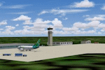
Denis Sassou N guesso Intl. Airport, Congo. This airport is missing in FS2004. Makes ECair AI-Traffic work.
| Filename: | FCOD__Oyo_Ollombo_Airport__Cuvette_Department_Cong.zip |
| License: | Freeware |
| Added: | 8th July 2016, 14:13:05 |
| Downloads: | 181 |
| Author: | Thomas Gierse |
| Size: | 179.3 KB |
| Category: Flight Simulator 2004 - Scenery | |
| VDSV - Sihanoukville International Airport - Sihanoukville, Cambodia |
|
Images related to this file:
File Description:
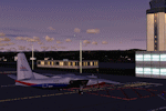
Sihanoukville VDSV airport Cambodia. Update to the standard scenery to make AI-Traffic work.
| Filename: | VDSV__Sihanoukville_International_Airport__Sihanou.zip |
| License: | Freeware |
| Added: | 8th July 2016, 14:16:48 |
| Downloads: | 224 |
| Author: | Thomas Gierse |
| Size: | 1009.47 KB |
| Category: Flight Simulator 2004 - Scenery | |
| 8AK7 - Bullen Point - Alaska North Slope 7 |
|
Images related to this file:
File Description:
The town of Barrow is in the far north of Alaska, and these are coastal villages or radar installations to the west, south, and now east of Barrow. There will be further additions. Bullen Point is a DEW station Air Force base 240 miles east of Barrow and 75 miles east of Oliktok. The runway is just under 4,000 feet of gravel and aligned 05-23; this is approximately at right angles to the default FS9 alignment and how that came about is something I doubt Bill Gates could explain. Most of the DEW buildings have now been removed (including the large hangar, which is unusual) but as I had a layout I made the whole site as it was originally, way back in the days when the north slope was still a wilderness. The AI is one day a C-130, on another a Cessna, and on a third a DC3. When I started this North Slope series it was my intention to create the full monty and make all the oil and gas installations and Deadhorse airport etc. I have come to realise that the oil side is impossible to make. There is so much of it and each bit is as time consuming as Heathrow while the actual airfields are more like Rockcliffe CYRO, so a lot of effort for what is just background to an adjoining airfield. But at the same time, if I make the new airstrips it is impossible NOT to make the oil installations as they are the dominating feature. So no new airstrips, and this is going to be just the 1960's or 1970's, when the oil business was only exploratory and the airfields were for villages or DEW stations, and Harmon Helmerick had his dirt strip on the Colville River estuary and was guiding hunters and fishermen and had just started to help out Sinclair Oil with oil exploration in 1966. Read his book. Download my previous post of his field.
| Filename: | 8AK7__Bullen_Point__Alaska_North_Slope_7.zip |
| License: | Freeware, limited distribution |
| Added: | 15th July 2016, 17:46:54 |
| Downloads: | 280 |
| Author: | Roger Wensley |
| Size: | 2.5 MB |
| Category: Flight Simulator 2004 - Scenery | |
| Ford-Timor (Jump Ramp Heaven) |
|
Images related to this file:
File Description:
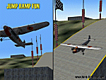
6 different layers in one pack. This scenery pack is a fun experiment in Jump Ramp development - to get aircraft to launch into the air.
Many different angles and many different challenges for your fun flying pleasure.
Contains lots of small and large Jump Ramps, a couple of Ski Ramps and a Grass up/down Hill Runway.
Also contains an Aircraft Carrier with two jump ramps and an Airship with a runway and jump ramp on top.
All set up on 6 different height levels - absolute fun flying and some great challenges for takeoff and landings.
BONUS AIRFIELDS
For those that already have Ford-Blackhawk, Ford-Brazil and Ford-Switzerland installed - a collection of files are included in the Ford-Timor project that will add ramps and jumps to these packages.
Slideshow to show you what is included:
http://www.ford-tri-motor.net/Slideshows/JUMP_RAMP_HEAVEN.html
| Filename: | FordTimor_Jump_Ramp_Heaven.zip |
| License: | Freeware, limited distribution |
| Added: | 16th July 2016, 14:34:48 |
| Downloads: | 80 |
| Author: | Garry J. Smith - Ford Project Team |
| Size: | 3.91 MB |
| Category: Flight Simulator 2004 - Scenery | |
| KECP - Panama City, Florida ** UPDATED ** |
|
File Description:
Panama City has been changed upgrade objects and few mistakes for frequency radio is back working now. High rise hotels additional are on along beaches.
| Filename: | KECP__Panama_City_Florida___UPDATED_.zip |
| License: | Freeware |
| Added: | 18th July 2016, 09:42:55 |
| Downloads: | 578 |
| Author: | Stuart John Gilbert II |
| Size: | 2.08 MB |
| Category: Flight Simulator 2004 - Scenery | |
| PABA - Barter Island (Kaktovik) - Alaska North Slope 8 |
|
Images related to this file:
File Description:
The town of Barrow is in the far north of Alaska, and these are coastal villages or radar installations to the west, south, and now east of Barrow. There will be further additions. Barter Island is a DEW station Air Force base 310 miles east of Barrow and 75 miles east of Bullen Point. The runway is just under 5,000 feet of gravel and aligned 06-24 on a spit of land at the northeast corner of the island. The big hangar is still there on the apron. Most of the DEW buildings have now been removed but this scenery is dated around 2005 when there were more of them still there. Between the DEW station and the airstrip is the village of Kaktovik, with a population of some 300 mainly traditional Inupiat. The village was first pioneered when the DEW station was built in the 1950's and grew as the years passed. The FS9 error discovered when making this scenery was that FS9 had mistakenly "placed" Kaktovik at Bullen Point (not physically, it was just wrongly stated as the local town); this is now only partly corrected as FS9 refused to accept my Bullen Point revision but allowed me to associate Kaktovik with Barter Island. Kaktovik is definitely on Barter Island. I could also mention that the runway was in the sea, but there isn't much point in that as Bill would say it was all the fault of Ultimate Terrain, so I won't bother. The next DEW station to the east is in Canada and called Komakuk; this has already been made and posted. The next in this series will be far to the west. The AI has daily flights by ERA, plus Northern Air Cargo, and some GA.
| Filename: | PABA__Barter_Island_Kaktovik__Alaska_North_Slope_8.zip |
| License: | Freeware, limited distribution |
| Added: | 19th July 2016, 17:49:16 |
| Downloads: | 210 |
| Author: | Roger Wensley |
| Size: | 3.42 MB |


© 2001-2026 AVSIM Online
All Rights Reserved
Privacy Policy |