
Where Flight Simulation Enthusiasts Gather from Around the World!
AVSIM Library - Search Results

| Category: Flight Simulator 2004 - Scenery | |
| St. George (KSGU) / Mesquite (67L), Utah/Nevada, Photo-Scenery (FS9 & FSX) |

|
Images related to this file:
File Description:
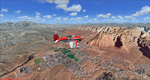
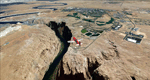
Covers the area between St. George, Utah and Mesquite, Nevada. To the north of St. George
the Pine Valley Mountains with their foothills of scenic red sandstone loom over the city.
St. George Municipal Airport (KSGU) is mostly used for general aviation but is also served by SkyWest Airlines
on behalf of Delta Connection. Because of it's location on a mesa this airport can't be expanded and so a new
airport is currently being built southeast of the city at the site of an abandoned airfield. The opening
is expected in 2011. To the south of the city make sure, you don't miss the Virgin River Gorge where the
Virgin River winds thru a long winding canyon in the transition zone between the red rocks of southern Utahs
Colorado Plateau and Nevadas Mojave Desert. Shortly afterwards you reach Mesquite which is situated just
west of the Arizona stateline. Like nearly all Nevada cities near the stateline Mesquite is home to several
Casinos. Mesquite Airport (67L) lies just north of the city.
High resolution versions of this scenery for FS9 and FSX (much sharper, but larger and multiple downloads)
are available at www.blueskyscenery.com/CNY_South3West6.html . The screenies are taken from the high-res versions,
so expect this version to be slightly more blurry. Thanks to Joop Mak for providing custom AFCADs that
correct airport layouts so that they align with the photo-textures! They are available at www.blueskyscenery.com/AFCADs.html .
YourDonation@Work: Dedicated to Werner, Ralf-Peter and Nels.
| Filename: | St_George_KSGU__Mesquite_67L_UtahNevada_PhotoScene.zip |
| License: | Freeware, limited distribution |
| Added: | 24th March 2010, 19:41:43 |
| Downloads: | 1,649 |
| Author: | Gottfried Razek - blueskyscenery.com |
| Size: | 95.58 MB |
| Category: Flight Simulator 2004 - Scenery | |
| Page (KPGA), Lake Powell West, Utah/Arizona, Photo-Scenery (FS9 & FSX) |
|
Images related to this file:
File Description:
This scenery covers the western part of Lake Powell, the city of Page (KPGA), the Vermillion Cliffs, Glenn Canyon just south of Glenn Canyon Dam, the northern part of Marble Canyon, Paria Canyon, Cockscomb, etc, etc. Spectacular! To explore the scenery depart from Page Municipal Airport (KPGA). High resolution versions of this scenery for FS9 and FSX (much sharper, but larger and multiple downloads) are available at www.blueskyscenery.com/CNY_South3West3.html . The screenies are taken from the high-res versions, so expect this version to be slightly more blurry. YourDonation@Work: Dedicated to William, Veit and Michele.
| Filename: | Page_KPGA_Lake_Powell_West_UtahArizona_PhotoScener.zip |
| License: | Freeware, limited distribution |
| Added: | 3rd March 2010, 21:26:32 |
| Downloads: | 1,817 |
| Author: | Gottfried Razek - blueskyscenery.com |
| Size: | 92.41 MB |
| Category: Flight Simulator 2004 - Scenery | |
| Park County, Colorado, Photo-Scenery (FS9 & FSX) |
|
Images related to this file:
File Description:

Covers the gap between my Leadville and Colorado Springs North sceneries and provides you with continuous coverage for longer cross country flights. High resolution versions of this scenery for FS9 and FSX (much sharper, but larger and multiple downloads) are available at www.blueskyscenery.com/GNB_South2.html . The screenies are taken from the high-res versions, so expect this version to be slightly more blurry. YourDonation@Work: Dedicated to Arthur and Pierre-Alain.
| Filename: | Park_County_Colorado_PhotoScenery_FS9__FSX.zip |
| License: | Freeware, limited distribution |
| Added: | 3rd February 2010, 22:19:58 |
| Downloads: | 1,420 |
| Author: | Gottfried Razek - blueskyscenery.com |
| Size: | 89.49 MB |
| Category: Flight Simulator 2004 - Scenery | |
| Kawita = 3 Québec Bush Sceneries |
|
File Description:
There are three sceneries in this file. Kawita Outpost, Kawita Hunting Camp and Kawita Fishing Camp. All are very close together. Kawita Hunting Camp's field is 'tricky' to get in and out (fun to practice if you have a good plane for it). Kawita Outpost has lit fires for night flying. Lots of candies including animated Northern Lights (aurora borealis)
| Filename: | Kawita__3_Qubec_Bush_Sceneries.zip |
| License: | Freeware |
| Added: | 19th December 2005, 04:24:13 |
| Downloads: | 1,177 |
| Author: | Leon Louis |
| Size: | 5.15 MB |
| Category: Flight Simulator 2004 - Scenery | |
| LGTS Fix |
|
File Description:
his is a fix file for the makedonia airport in Thessaloniki, Greece from Vangelis Vasilias and George Dorkofikis (Filename makedonia10.zip and fix for FS2002 filename lgts_fix.zip).
The scenery is still not 100% FS2004 compatible, but this fix removes the default FS buildings that appear in the middle of the parking area.
| Filename: | LGTS_Fix.zip |
| License: | Freeware |
| Added: | 3rd February 2004, 20:13:59 |
| Downloads: | 4,432 |
| Author: | Oren Geva |
| Size: | 373.28 KB |
| Category: Flight Simulator 2004 - Scenery | |
| Groton-New London Sub Base |
|
File Description:
FS2004 Scenery - Naval Submarine Base New London Groton CT. On the east bank of the Thames River near Groton, CT, New London Naval Submarine Base was the birthplace of the submarine force. It was originally a Navy yard, converted to a submarine base in 1916, and greatly expanded in World War II. The advent of nuclear power required an improvement in training and support facilities. By 1959, New London had become the largest submarine base in the world with 8,210 active personnel. The base was recommended for closure by the DoD in the 2005 BRAC Recommendations. Created using Instant Scenery by John B. Loney, Jr.
| Filename: | GrotonNew_London_Sub_Base.zip |
| License: | Freeware, limited distribution |
| Added: | 31st March 2008, 03:07:08 |
| Downloads: | 1,040 |
| Author: | John B. Loney, Jr. |
| Size: | 3.79 MB |
| Category: Flight Simulator 2004 - Scenery | |
| Bromont Regional Airport, Québec Short Hops |
|
File Description:
Bromont is situated some 40 miles South East of Montréal, Québec. It is a very important airfield with full facilities including a gliding center. Soaring is possible if you have the thermal files (details included). Lots of candies on this site. Sounds are included for those who have Lago Scenery Enhancer.
| Filename: | Bromont_Regional_Airport_Qubec_Short_Hops.zip |
| License: | Freeware |
| Added: | 15th February 2004, 22:35:22 |
| Downloads: | 3,536 |
| Author: | Leon Louis |
| Size: | 3.72 MB |
| Category: Flight Simulator 2004 - Scenery | |
| WWII era Midway Islands |
|
File Description:
FS2004 World War II era scenery for Midway Island (PMDY) in the Pacific. Custom scenery to re-create (loosely) Midway atoll with the aviation facilities on Eastern Island as they were during the war and with the seaplane station on Midway. Simple, high frame-rate scenery suitable for multiplayer and CFS2 use. Period AI available in a seperate download under file name PMDY_AI_J.zip.
| Filename: | WWII_era_Midway_Islands.zip |
| License: | Freeware, limited distribution |
| Added: | 21st February 2009, 13:32:57 |
| Downloads: | 1,719 |
| Author: | John Stinstrom |
| Size: | 1.59 MB |
| Category: Flight Simulator 2004 - Scenery | |
| RAF Bovingdon EGWX 1955 |
|
File Description:
Bovingdon was a London airport of some importance and used as an alternate by (at least) BOAC and Pan Am after the Second World War, partly because its elevation of just over 500 feet made it less subject to poor visibility than London Heathrow. It had been built for RAF four-engined bombers near the village of Bovingdon in Hertfordshire and was used by Bomber Command from June 1942 but transferred to the US Eighth Air Force in August. They only flew operational missions with B-17s for a brief period and after that it was employed for crew training until September 1944 when it became the base for the European Air Transport Service. It was returned to the RAF in 1947 but handed over for use by civilian airlines while retaining significant military roles. The RAF Fighter Command Communication Squadron was based there and in 1951 the USAF assigned the C-47s of the 7531st Air Base Squadron to it, though other USAF types visited in large numbers on a transitory but routine basis. The USAF left in October 1962 but the RAF remained there until the airfield was closed in 1972. This scenery recreates Bovingdon, with period traffic, as it was in 1955.
| Filename: | RAF_Bovingdon_EGWX_1955.zip |
| License: | Freeware |
| Added: | 18th February 2025, 15:28:48 |
| Downloads: | 95 |
| Author: | CalClassic, Ken Lawson, Al Von Pingel |
| Size: | 15.09 MB |
| Category: Flight Simulator 2004 - Scenery | |
| Norfolk International Airport 2004 |
|
File Description:
Norfolk International Airport for FS2004/FS9 is finally here! This package contains many improvements over previous versions including new taxiway/apron surfaces, reduced polygon count, correction of default roads/waterlines, a new AFCAD2, and even the I-64 bridge at the end of runway 23. If you haven't flown Norfolk yet, come out and see what flying one of the nation's top 65 airports is all about! (Requires Gerrish Gray's trees_v3.zip)
| Filename: | Norfolk_International_Airport_2004.zip |
| License: | Freeware |
| Added: | 8th March 2004, 03:15:27 |
| Downloads: | 9,138 |
| Author: | Matthew Perry |
| Size: | 6.02 MB |
© 2001-2026 AVSIM Online
All Rights Reserved
Privacy Policy |