
Where Flight Simulation Enthusiasts Gather from Around the World!
AVSIM Library - Search Results

| Category: Flight Simulator 2004 - Scenery | |
| Rouen Photoscenery v2.11 |

|
Images related to this file:
File Description:
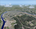
Rouen photoscenery. Around 200 square km summer photoscenery including Rouen city and LFOP airport background. It does not contain night or seasonal textures. It includes an optimized re-mesh and some characteristics 3D elements. It is provided with part of the custom autogen cover, specially around the AD.
| Filename: | Rouen_Photoscenery_v211.zip |
| License: | Freeware, limited distribution |
| Added: | 4th January 2010, 19:13:48 |
| Downloads: | 3,973 |
| Author: | Alain Nicco |
| Size: | 7.57 MB |
| Category: Flight Simulator 2004 - Scenery | |
| Newport, Oregon - KONP. A conservative enhancement of the Newport, Oregon airport. |
|
Images related to this file:
File Description:
Newport, Oregon - KONP. A conservative enhancement of the Newport, Oregon airport which lies some 130 miles Southwest of Portland, Oregon. Featured is an AI U.S. Coast Guard Helicopter (included in the package) making training and reconnaissance flights over and around the area. Also included is a new bridge allowing the fishing fleet access to and from the bay. Tillamook, which is just North of Newport, is famous for it's cheese but you will find much more to enjoy on this portion of the Oregon coastline. Default, RWY12 and EZ scenery objects were used in this project. Please unzip to a temporary folder and follow the easy installation instructions. Compiled for your flying enjoyment by David "Opa" Marshall.
| Filename: | Newport_Oregon__KONP__A_conservative_enhancement_o.zip |
| License: | Freeware |
| Added: | 31st January 2010, 21:22:48 |
| Downloads: | 4,051 |
| Author: | David "Opa" Marshall |
| Size: | 2.52 MB |
| Category: Flight Simulator 2004 - Scenery | |
| Denali Park Research Base |
|
Images related to this file:
File Description:
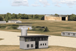
A fictitious research base located 16 nautical miles west of Denali airport (AK06). It is owned and operated by NWS and used by several agencies including park service, various concessionaires, Fish and Game, Law enforcement and Medical/search and rescue agencies.
It has a runway only marked by barrels emitting heavy smoke along with crew barracks, main base building w/comm center, covered parking for snowcats and cargo/supplies. there are other buildings and a very large communications tower on the south side of the runway which parallels the river. It has an NDB of 351.2 (ADF).
Get hired to bring in cargo from Denali and other nearby airports. Made with Instant Scenery and various object libraries.
Best approach is from the north and the smoking barrels only mark a short section of the available landing area. Read the txt file for more info and have a great fly to the research base. By savageagle.
| Filename: | Denali_Park_Research_Base.zip |
| License: | Freeware |
| Added: | 1st February 2010, 09:35:25 |
| Downloads: | 279 |
| Author: | Tim Durham |
| Size: | 3.46 MB |
| Category: Flight Simulator 2004 - Scenery | |
| Collings and Mansfield |
|
File Description:
FS2004 Scenery - In 1979 the Collings Foundation was founded to support "living history" events involving transportation. Originally founded with the focus of automobiles, the foundation moved to aircraft as the need for quality aviation history exhibits grew. Mansfield Municipal Airport (1B9) serves Mansfield and Bristol County, MA and is owned by the Town Of Mansfield. The airport has more than one runway. The longest is a paved runway extending 3498 feet. The facility is at an elevation of 122 feet. Created using Instant Scenery by John B. Loney, Jr.
| Filename: | Collings_and_Mansfield.zip |
| License: | Freeware, limited distribution |
| Added: | 3rd February 2010, 02:07:34 |
| Downloads: | 247 |
| Author: | John B. Loney, Jr. |
| Size: | 1.78 MB |
| Category: Flight Simulator 2004 - Scenery | |
| Emsdale CNA4 & Emsdale South fields in Ontario, Canada |
|
Images related to this file:
File Description:
Emsdale is on Hwy 11 about midway between North Bay and Lake Simcoe. A mile north of the town is Emsdale airfield CNA4, with two grass runways that are 12/30 2,500 feet long, and 17/35 2,000 feet long. There is only one hangar, no fuel, and in general there does not appear to be a lot of action. "Grass" may be a generous description of the runway surface, particularly for 12/30.
The second field is two miles southwest of Emsdale and privately owned. It has 2,700 feet or so of asphalt runway and a parallel grass runway (which is short at under 800 feet, plus a hangar at the north end!). There are six buildings, between hangars and office or club house and that about sums up all I know about it. If anyone knows more about this field please let me know.
| Filename: | Emsdale_CNA4__Emsdale_South_fields_in_Ontario_Cana.zip |
| License: | Freeware |
| Added: | 3rd February 2010, 15:35:35 |
| Downloads: | 390 |
| Author: | Roger Wensley |
| Size: | 1.91 MB |
| Category: Flight Simulator 2004 - Scenery | |
| SADZ - Matanza Buenos Aires |
|
File Description:
Scenery of airfield Matanza situated 8 NM SW of Buenos Aires:
ICAO Code: SADZ
Features:
- Contain Hangars with moving doors at frequences: NAV2 114.0 and NAV2 112.5
- Gas station, tower, plane parking
| Filename: | SADZ__Matanza_Buenos_Aires.zip |
| License: | Freeware |
| Added: | 5th February 2010, 07:04:54 |
| Downloads: | 224 |
| Author: | Stanislao Senese |
| Size: | 2.49 KB |
| Category: Flight Simulator 2004 - Scenery | |
| 42VA - Virginia Beach Airport & Museum (v1.1) |
|
Images related to this file:
File Description:

42VA - Virginia Beach Airport & Museum V1.1, located in Virginia Beach, VA USA.
This facility is a private airport used by the Fighter Factory to maintain, display and fly vintage and replica aircraft, mainly from the World War 2 era. The art deco building, grass landing strip, checkered water tower and hangars are home to one of the world's largest private collection of vintage aircraft.
Most objects using custom photo-real 32bit textures designed in GMAX. Optional DXT3 textures included. Also includes new AFCAD file, more accurate airport grounds perimeter, area roads, animated hangar doors, and area landclass. No AI traffic included with this release, but AI functionality designed into AFCAD. By EdGeneer Cox.
| Filename: | 42VA__Virginia_Beach_Airport__Museum_v11.zip |
| License: | Freeware, limited distribution |
| Added: | 5th February 2010, 16:39:44 |
| Downloads: | 1,599 |
| Author: | Ed Geneer Cox |
| Size: | 30.59 MB |
| Category: Flight Simulator 2004 - Scenery | |
| EDOV-04 |
|
Images related to this file:
File Description:
FS2004 scenery--Borstel airport EDOV near
Stendal in Sachsen Anhalt Germany.
Originally a WWII paratroops base, later
base of soviet jetfighters and helicopters,
but now in civilian use. By Thomas Erthner.
| Filename: | EDOV04.zip |
| License: | Check within download |
| Added: | 13th February 2010, 01:04:00 |
| Downloads: | 1,071 |
| Author: | Thomas Erthner |
| Size: | 2.25 MB |
| Category: Flight Simulator 2004 - Scenery | |
| Herb's Field C417 near Ottawa in Ontario, Canada |
|
Images related to this file:
File Description:
Herb's is on the 417 between Ottawa and Montreal at the junction with highway 34, which is south of Hawkesbury. Herb's is a truckstop and a repair garage and a restaurant and a gas station, and is still (but only just!) an airfield. Which is to say there is still a runway, some 1,200 feet long and 30 feet wide. Do not go in your Cessna 172 as only the northern half is usable, and that after inspection from the air for any obstacles, parked cars, dogs, and similar obstacles. The southern half is the way in for trucks and cars, so make sure you can stop well before the ex-hangar which is now for truck repairs only. The planes all belonged to Herb's father, and even a casual inspection will reveal that they haven't moved for some time. If there is anything using the service road immediately to the north of the runway go around again, you won't be able to clear a vehicle and then land on the threshold.
| Filename: | Herbs_Field_C417_near_Ottawa_in_Ontario_Canada.zip |
| License: | Freeware, limited distribution |
| Added: | 14th February 2010, 14:39:56 |
| Downloads: | 386 |
| Author: | Roger Wensley |
| Size: | 2.02 MB |
| Category: Flight Simulator 2004 - Scenery | |
| Chelsea Dams on the Gatineau River |
|
Images related to this file:
File Description:
The Chelsea Dams are on the Gatineau River, just north of Rockcliffe airfield. I have used the plural as while there is only one dam as such, there is a second generating station just south of the dam; so "it" is more generally called "the Chelsea Dams". The dams mark the point where, if you are flying south down the Gatineau River towards Rockcliffe, you should be either below 1,500 feet or talking to the Ottawa control tower. While not a reporting point as noted in the supplement notes about flying vfr in the Ottawa area the dams are still the natural reporting point when approaching Rockcliffe and announcing landing intentions. Plus they are a visible landmark from way off, so here they are.
| Filename: | Chelsea_Dams_on_the_Gatineau_River.zip |
| License: | Freeware, limited distribution |
| Added: | 14th February 2010, 23:11:15 |
| Downloads: | 255 |
| Author: | Roger Wensley |
| Size: | 879.08 KB |
© 2001-2026 AVSIM Online
All Rights Reserved
Privacy Policy |