
Where Flight Simulation Enthusiasts Gather from Around the World!
AVSIM Library - Search Results

| Category: Flight Simulator 2004 - Scenery | |
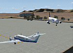
| Factory Field CF40 in Quebec Canada |

|
Images related to this file:
File Description:
Factory Field (my name for it) is in Quebec on highway 321 a few miles north of St Andre Avellin, and 40 miles ENE of Ottawa. The runway is 3,500 feet long and asphalt and went out of regular use in the early 1990's when the airfield was closed. It was sold in 1995 to a company (ELP) that has built up a factory for manufacturing and fitting snow ploughs and other pneumatically operated equipment to trucks, and who now use the runway for testing their snow ploughs. In between times, as it is not marked closed with an "X", it is also occasionally used by customers who fly in, usually to get the drivers there to take delivery of completed trucks. The surface is good and there are no obstructions but also no markings, though with 3,500 feet of 100 feet wide asphalt there is plenty of space and it doesn't much matter.
| Filename: | Factory_Field_CF40_in_Quebec_Canada.zip |
| License: | Freeware, limited distribution |
| Added: | 13th May 2010, 22:11:41 |
| Downloads: | 347 |
| Author: | Roger Wensley |
| Size: | 1.27 MB |
| Category: Flight Simulator 2004 - Scenery | |
| Hauraki Gulf, v6 |
|
Images related to this file:
File Description:
This replaces all my previous Pakatoa Island and Hauraki Gulf sceneries. You must have Christian Stock's NZ mesh in the form of "Mountains of New Zealand" and topo in the form of "Lakes and Rivers of New Zealand" (payware).
New additions...PAKIHI ISLAND: Small jetty and nearby buildings. TAKANGAROA ISLAND: House on Island. House & Jetty island north of Takangaroa Island. MOTUREKAREKA ISLAND: Wreck of the Rewa. PONUI ISLAND: Chamberlain's Bay Airstrip. Chamberlain's Donkey Farm. Third Bay Airstrip. Motunau Bay Jetty. KARAMURAMU ISLAND: Jetty and quarry. ROTOROA ISLAND: Rotoroa Jetty. MOTUIHE ISLAND: Motuihe Wharf.
| Filename: | Hauraki_Gulf_v6.zip |
| License: | Freeware |
| Added: | 17th April 2010, 16:10:12 |
| Downloads: | 218 |
| Author: | Godfrey Tier |
| Size: | 6.61 MB |
| Category: Flight Simulator 2004 - Scenery | |
| Helmericks 22AK on the North Slope, Alaska |
|
Images related to this file:
File Description:
Helmericks is on the northern coast of Alaska, 150 miles east of Barrow and 50 miles west of Prudhoe Bay. It is on the shore of Colville Island in the delta of the Colville River, and hasn't changed much from when Harmon Helmericks set up house there in the late 1950's. He lived there with his wife and two sons guiding hunting trips and running a fishing operation, and then in 1966 he was involved in the first north slope exploratory oil well drilling operation by Sinclair Oil, which was to lead to the opening up of the north slope in the 1970's. Read "The last of the Bush Pilots" if you want to know more about it. The dirt runway is around 2,400 feet long (long enough for the Wien DC3 to get in with supplies) and the house is still there along with storage sheds. To the southwest are the other houses (three of them) which make up the rest of Colville Village. If you want to have the frozen lakes and river and sea then look for my recent post which will freeze them until you get bored and want to put your floats back on.
| Filename: | Helmericks_22AK_on_the_North_Slope_Alaska.zip |
| License: | Freeware, limited distribution |
| Added: | 17th April 2010, 16:21:03 |
| Downloads: | 392 |
| Author: | Roger Wensley |
| Size: | 1.22 MB |
| Category: Flight Simulator 2004 - Scenery | |
| Belize, Lamanai Airfield |
|
Images related to this file:
File Description:
Lamanai is Belize's newest and most controversial airfield. It was built to facilitate access to the Lamanai archaeological sites (the limited area you see in your GPS while flying over).
| Filename: | Belize_Lamanai_Airfield.zip |
| License: | Freeware, limited distribution |
| Added: | 4th May 2010, 09:12:40 |
| Downloads: | 188 |
| Author: | Alf B. Meier |
| Size: | 204.45 KB |
| Category: Flight Simulator 2004 - Scenery | |
| Wadi Seidna, Sudanese Air base |
|
Images related to this file:
File Description:
It's a fictionally scenery based on Google earth picture, about a military base in Sudan, called Wadi Seidna, home (maybe) of Sudanese Air force MIG29 FULCRUM squadron.
You required some libraries (from MAIW and EZ-Scenery) for complete functionality.
| Filename: | Wadi_Seidna_Sudanese_Air_base.zip |
| License: | Freeware |
| Added: | 4th May 2010, 09:14:52 |
| Downloads: | 536 |
| Author: | Luciano Franchini |
| Size: | 166.38 KB |
| Category: Flight Simulator 2004 - Scenery | |
| Terrain Mesh (LOD08) for Nunavut, Canada (File 4 of 4) |
|
File Description:
Re-uploaded file. FS2002 and FS2004. The files in this package contain a new 153m (LOD08) terrain mesh for Nunavut, Canada ( and northern part of Northwest Territories) to use with FS2002 and FS2004. The source data is GeoBase (CDED-1 : 250 000). All data were compiled and edited in MicroDEM 7.01 alpha and resampled to LOD08 (Level of Details), or 152.88 meters horizontal resolution, with the Microsoft Terrain Software Developer's Kit (SDK) utilities.
(Nunavut8a.zip, Nunavut8b.zip Nunavut8c.zip Nunavut8d.zip - 4 Parts).
| Filename: | Terrain_Mesh_LOD08_for_Nunavut_Canada_File_4_of_4.zip |
| License: | Freeware, limited distribution |
| Added: | 5th May 2010, 09:14:41 |
| Downloads: | 4,253 |
| Author: | Gilles Gauthier |
| Size: | 30.7 MB |
| Category: Flight Simulator 2004 - Scenery | |
| Hoodriver Bridge |
|
File Description:
FS2004 Hoodriver-Bridge
For use with Holdger Sandmanns Columbia_River_Gorge_scenery.
Fly 10deg from 4S2 untill you reach Columbia River
located in the US, connecting Oregon and Washington.
Landable for Helicopters, 3 LOD-Level, ships can pass it.
By Papa Looser
| Filename: | Hoodriver_Bridge.zip |
| License: | Freeware |
| Added: | 5th May 2010, 21:44:29 |
| Downloads: | 1,670 |
| Author: | Papa Looser |
| Size: | 809.83 KB |
| Category: Flight Simulator 2004 - Scenery | |
| Norfolk Trees pt2 |
|
File Description:
This pack will place trees into the scenery for Norfolk UK for FS9. It is designed to be compliant with VFR Photographic Scenery, VFR Terrain part 1 and the UK2000 scenery. The scenery has been created using GianP's agen_x trees and Tree Planter by George Davison.
Part Two covers the area in an arc approximately 10 miles to the west and south of Norwich and is contiguous with part one.
If you have parts one and two installed you will now have tree cover for over 240 square miles of Norfolk comprising of more than 250,000 trees, the large majority of which have been �¢����hand planted�¢����
| Filename: | Norfolk_Trees_pt2.zip |
| License: | Freeware |
| Added: | 5th May 2010, 22:09:32 |
| Downloads: | 347 |
| Author: | Norman Dean |
| Size: | 1.15 MB |
| Category: Flight Simulator 2004 - Scenery | |
| OPGD Gwadar International, Pakistan |
|
Images related to this file:
File Description:
Googly scenery for OPGD Gwadar International, Pakistan. In Flight Simulator
2004 only general aviation parking is provided at this so-called international airport but in the real world it is served two or three times a day by Airbii of Airblue and ATRs of Pakistan International Airways. These scenery files improve or add
aprons, taxiways, buildings and other airport features to Flight Simulator's limited
representation and allow "AI" traffic to land, taxi, park and take off in a realistic
manner.
The scenery does not purport to be ultra-accurate. Based on high-detail satellite
imagery from Google Earth, the layout is proportionally correct but the added
airport features, such as buildings, are built from default Microsoft objects
and add-on libraries so will not look like the real thing.
You are not obliged to download and install any additional scenery libraries,
but to enjoy this scenery in its entirety, you may wish to. It will work fine,
with or without.
[File re-uploaded at request of AVSIM]
| Filename: | OPGD_Gwadar_International_Pakistan.zip |
| License: | Freeware |
| Added: | 15th May 2010, 23:51:51 |
| Downloads: | 170 |
| Author: | John Hinson |
| Size: | 58.09 KB |
| Category: Flight Simulator 2004 - Scenery | |
| EDDN Nurnberg two colored RWY and TWY |
|
Images related to this file:
File Description:
Only for the default scenery. Change the concrete RWY and TWY's to the mixed real one. Thanks to Steffen D and Lee Swordy. By HOUSE-RP, Switzerland
| Filename: | EDDN_Nurnberg_two_colored_RWY_and_TWY.zip |
| License: | Freeware, limited distribution |
| Added: | 6th April 2010, 21:13:41 |
| Downloads: | 772 |
| Author: | HOUSE-RP |
| Size: | 17.62 KB |
© 2001-2026 AVSIM Online
All Rights Reserved
Privacy Policy |