
Where Flight Simulation Enthusiasts Gather from Around the World!
AVSIM Library - Search Results

| Category: Flight Simulator 2004 - Scenery | |
| Lake Powell, Navajo Mountain (04UT), Utah/Arizona, Photo-Scenery (FS9 & FSX) |

|
Images related to this file:
File Description:
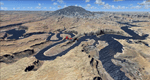
This package contains the center of Lake Powell and the Navajo Nation around Navajo Mountain. It contains remote areas of stunning beauty. Wonderful sandstone formations in bright shades of red and pink. Contains landmarks like the Rainbow Bridge National Monument and the confluence of the Colorado and San Juan Rivers. Extends my Monument Valley scenery to the west and brings you another 3.500 sq km in 4.7m/pix quality. To explore the scenery depart from Navajo Mountain dirt strip (04UT). High resolution versions of this scenery for FS9 and FSX (much sharper, but larger and multiple downloads) are available at www.blueskyscenery.com/CNY_South3West2.html . The screenies are taken from the high-res versions, so expect this version to be slightly more blurry. YourDonation@Work: Joaquin, Donald and Scott.
| Filename: | Lake_Powell_Navajo_Mountain_04UT_UtahArizona_Photo.zip |
| License: | Freeware, limited distribution |
| Added: | 23rd January 2010, 23:06:49 |
| Downloads: | 1,788 |
| Author: | Gottfried Razek - blueskyscenery.com |
| Size: | 91.43 MB |
| Category: Flight Simulator 2004 - Scenery | |
| Capitol Reef National Park/North - Hanksville (KHVE), Utah, Photo-Scenery |
|
Images related to this file:
File Description:
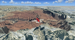
Capitol Reef National Park/North - Hanksville (KHVE), Utah, Photo-Scenery (for FS9 & FSX)
This scenery covers the northern part of Capitol Reef National Park, Hanksville (KHVE), the Goblin Valley and extends north to I70 and the San Rafael Swell. It extends my Canyonlands sceneries to the west and brings you another 3.500 sq km in 4.7m/pix quality. To explore the scenery depart from Hanksville (KHVE) and head northwest. High resolution versions of this scenery for FS9 and FSX (much sharper, but larger and multiple downloads) are available at www.blueskyscenery.com/CNY_West2.html . The screenies are taken from the high-res versions, so expect this version to be slightly more blurry. YourDonation@Work: Dedicated to Andy and Robert.
| Filename: | Capitol_Reef_National_ParkNorth__Hanksville_KHVE_U.zip |
| License: | Freeware, limited distribution |
| Added: | 13th January 2010, 19:32:33 |
| Downloads: | 1,693 |
| Author: | Gottfried Razek, blueskyscenery.com |
| Size: | 94.77 MB |
| Category: Flight Simulator 2004 - Scenery | |
| Australian Lighthouses - Part 3 - Victoria |
|
File Description:
Around Australia's coastline there are over 350 lighthouses.
I received a suggestion a month ago asking if I would do the locations of the lighthouses down the coast of New South Wales and when I did a bit of research I thought, why not do the whole 36,735 kilometres around Australia?
Parts 1 and 2 have already been released (4th./5th. February 2006).
Here is Part 3 - the lighthouses located across the coastline of Victoria, between the borders of New South Wales in the east and South Australia to the west. I have also included the several lights that are located within Port Phillip Bay and Port Melbourne.
A Read Me file is included. No third-party items are required.
| Filename: | Australian_Lighthouses__Part_3__Victoria.zip |
| License: | Freeware |
| Added: | 5th February 2006, 22:27:57 |
| Downloads: | 2,681 |
| Author: | Bruce Kennewell |
| Size: | 251.49 KB |
| Category: Flight Simulator 2004 - Scenery | |
| Fairbanks PAFA / FAI Version 3.0 |
|
Images related to this file:
File Description:

This is a coplete rebuild of Fairbanks Int'l Airport. The passenger
terminals have been replaced with custom buildings, and the general aviation side of the field is buzzing
with life. Many static aircraft pepper the parking area and hangars are placed throughout. The AFCAD file
was built from the default version with AFX. This scenery was built using Flight1's Instant Scenery program.
Update:
This version contains the brand new passenger terminal as designed and built by Sidney Scwartz. The entire airport is rebuilt from scratch
along with an all new afcad featuring new ground texturing. The West side of the airport has also been remade to be much more accurate.
There is also an active water runway in use.
| Filename: | Fairbanks_PAFA__FAI__Version_30.zip |
| License: | Freeware |
| Added: | 18th August 2013, 18:37:22 |
| Downloads: | 2,843 |
| Author: | FRFStudio.net / William Morgan |
| Size: | 18.68 MB |
| Category: Flight Simulator 2004 - Scenery | |
| Nulato NUL in Alaska |
|
Images related to this file:
File Description:
Nulato is a small village on the west bank of the Yukon River, around 8 miles south of where the river turns from north-south to east-west, east being upstream towards the distant Fairbanks. The population is just under 300 and living from fishing and the land. During the late 1800's the village lived by the spin off from gold mining, such as supplying cut wood as fuel for the boats plying the Yukon River. In 1900 a measles epidemic cut the population down by a third, and in the early 1900's the gold mining moved to Nome and Fairbanks, with obvious results for local prosperity. The airfield is close by and has a gravel runway aligned 2-20 and just under 4,500 feet long. Apart from the airfield itself, and it's buildings, this scenery modifies the local land class, adds village buildings while reducing the village size to reality, and creates a new airfield background. Don't ask me about the odd arrangement of the airfield buildings, I have no idea why they are like that. Nulato is served by Wright Air from Fairbanks in the east and this is included in the AI. A note here about my scenery making. This is post number 508 and there will not be many more to follow this as I am almost at the end of the photos I either took or found for scenery purposes. There is a limit to what can be located online and I have already been making use of the little there is; eg Unalakleet. So, if you are near an airport (preferably Canadian or Alaskan) and have a camera..... Let me know.
| Filename: | Nulato_NUL_in_Alaska.zip |
| License: | Freeware, limited distribution |
| Added: | 25th August 2019, 17:34:25 |
| Downloads: | 104 |
| Author: | Roger Wensley |
| Size: | 3.05 MB |
| Category: Flight Simulator 2004 - Scenery | |
| Golden CYGE in British Columbia, Canada |
|
Images related to this file:
File Description:
This airfield is in one of the north-south valleys in the Columbia Mountains (which are part of the Rockies) on the border between BC and Alberta. The town of Golden (population just under 4,000) grew along with the Canadian Pacific Railway and the logging industry, both of which are still the mainstays of the town. Tourism is a more recent development along with the Kicking Horse Mountain Resort, which is only 3 miles to the west of the town. There are occasional flights into CYGE related to the richer echelon of tourist groups for Kicking Horse, particularly at the weekends; three actual such flights are included in the AI. Golden CYGE is immediately to the west of the town beside the Columbia River, with the 4,500 feet of asphalt runway aligned 14-32; right hand circuits for 32. There are no runway lights or landing aids, and no taxiway lights, so this airfield is for daylight use only. There is a helicopter company based on the field (Alpine) and a volunteer search and rescue group, a skydiving operation at the northern end, plus an active club with a long open hangar with a club room. A friendly airfield. The AI helicopter was included in my post of Alma CYTF. The Beaver will not show up unless you have the Aerosoft Beaver installed. I found the other planes without a problem on flightsim or avsim. Due to the surrounding terrain AI aircraft will usually impact high ground before landing and then just show up on their parking spots. A northern wind improves but does not totally solve this.
| Filename: | Golden_CYGE_in_British_Columbia_Canada.zip |
| License: | Freeware, limited distribution |
| Added: | 29th September 2018, 19:26:13 |
| Downloads: | 156 |
| Author: | Roger Wensley |
| Size: | 12.2 MB |
| Category: Flight Simulator 2004 - Scenery | |
| Fort Simpson Island CET4 - Northwest Territories, Canada |
|
Images related to this file:
File Description:
Fort Simpson Island is the fifth in a series of airfields that follow (approximately) in a southward direction the Mackenzie River. At the far northern end of the river there is Tuktoyaktuk, then Inuvik, Fort McPherson, Fort Good Hope, Deline, and then Wrigley, all posted. Fort Simpson Island is at 405 feet asl and on the west bank of the the Mackenzie, around 110 miles south of Wrigley at the junction of the Mackenzie and the Liard rivers. The town of Fort Simpson is on an island, and has a population of 1,250 or so folks. The Hudson Bay trading post was established here in 1822. The airport is right next to the town, and has 3,000 feet of gravel runway, though with a displaced threshold of 1,000 feet at each end (unmarked, on gravel) this is effectively 2,000 feet for landing. The Canada Flight Supplement lists the runway as being 100 feet wide; the gravel is definitely far less and the 100 refers to the width in the winter when you are landing on snow and don't care if there is gravel or grass underneath. There are no scheduled flights as these go to the nearby Fort Simpson CYFS. There is a mandatory radio frequency which is for both CYFS and CET4 and in this case I have set the "tower" to "manned" so you will report position and obey instructions. Runway 13 has right hand circuits. I have modified the Ultimate Terrain route for the Mackenzie Highway so that it remains on the west side of the river and does not wander randomly from one side to the other north of Fort Simpson.
| Filename: | Fort_Simpson_Island_CET4__Northwest_Territories_Ca.zip |
| License: | Freeware, limited distribution |
| Added: | 6th July 2014, 02:56:05 |
| Downloads: | 208 |
| Author: | Roger Wensley |
| Size: | 2.46 MB |
| Category: Flight Simulator 2004 - Scenery | |
| RAF Burtonwood 1955-1957 |
|
File Description:
Burtonwood was for many years the most important air base in the United Kingdom, at least in terms of its size and the amount of traffic which passed through it. Built for the RAF but taken over by the USAAF during the war, it played a major role in that war and then in the US commitment to the protection of Europe during the Cold War. The main east-west runway was extended to 9,000 feet while the others fell out of use, and a new control tower and terminal building opened in 1955. Then disaster struck, when the site began to suffer from mining subsidence. MATS left for Mildenhall in 1958 and by the following year the USAF had gone completely, although Burtonwood continued in use by the US Army until the early 1990s
| Filename: | RAF_Burtonwood_19551957.zip |
| License: | Freeware |
| Added: | 27th August 2022, 22:15:51 |
| Downloads: | 188 |
| Author: | Ken Lawson, Al Von Pingel, Dan French |
| Size: | 42.48 MB |
| Category: Flight Simulator 2004 - Scenery | |
| Fort Resolution CYFR in the Northwest Territories, Canada |
|
Images related to this file:
File Description:
Fort Resolution is on the south side of Great Slave Lake, 75 miles east of Hay River and just west of where the Slave River flows into the lake from Fort Smith. Fort Resolution, the oldest community in the Territories and once a vital link in the fur trade business, is a small town with a population of around 500. It was not included in the original FS9 or Ultimate Terrain so I have added it here.
The airfield is next to the town on the lakeshore. The runway is 4,000 feet of gravel with a displaced threshold at the southern (town) end; it is lit and there is PAPI. There are no scheduled flights to Fort Resolution, just occasional charters; the AI includes a stock FS9 Cessna and a Wasaya Airways PC12.
| Filename: | Fort_Resolution_CYFR_in_the_Northwest_Territories_.zip |
| License: | Freeware, limited distribution |
| Added: | 4th October 2013, 22:11:26 |
| Downloads: | 294 |
| Author: | Roger Wensley |
| Size: | 2.31 MB |
| Category: Flight Simulator 2004 - Scenery | |
| Emerald Lake |
|
File Description:
"Emerald Lake" (YEWA), Queensland, Australia.
Emerald Lake is the international headquarters and home base for EastWest Airlines VA and is situated 18 kilometres from Emerald. Emerald Lake is nestled on the foreshores of Lake Maraboon, Queensland's second largest lake. It is 265 km west of Rockhampton and 900km from Brisbane. The lake is a massive 15000 hectares surface area.
Emerald Lake consists of two ILS runways 13000’ & 6000’ a space-age international and domestic terminal cluster using 8 Skyways, super sized hangars to accommodate future super jets, a flying club, cargo division, RFDS Base and a fully manned tower, a water runway and amphibian base.
There is a resort, a marina, residential area (under construction) on the shores of the lake adjacent to the airport and connected by a road network.
| Filename: | Emerald_Lake.zip |
| License: | Freeware |
| Added: | 2nd January 2006, 21:31:42 |
| Downloads: | 1,544 |
| Author: | Gregg Kirkwood |
| Size: | 4.83 MB |


© 2001-2026 AVSIM Online
All Rights Reserved
Privacy Policy |