
Where Flight Simulation Enthusiasts Gather from Around the World!
AVSIM Library - Search Results

| Category: Flight Simulator 2004 - Scenery | |
| Northwest Montana Landclass |

|
File Description:
This archive includes some simple landclass improvements for the Northwest Montana area. What I have found, is that the default landclass is pretty good, with exception to the towns of the area. There are several pretty good size towns in NW Montana, and they add to the scenery, so that is what I did.....changed the towns a bit. Also included is my landclass for Big Mountain Ski Resort at Whitefish, MT. This is my first attempt at this type of landclass, so it is not perfect. It is not intended to be a completely accurate facimile of The Big Mountain, but it does represent it pretty well.
| Filename: | Northwest_Montana_Landclass.zip |
| License: | Freeware |
| Added: | 30th January 2004, 02:44:44 |
| Downloads: | 1,587 |
| Author: | Fred Choate |
| Size: | 38.48 KB |
| Category: Flight Simulator 2004 - Scenery | |
| Chateau Airfield NZ22, & Chateau Hotel Village, Mount Ruapehu, New Zealand. |
|
File Description:
Welcome to the Chateau Airfield, the home of Mountain Air. The airfield is located on the foothills
of Togariro National Park's, Mount Ruapehu in the central North Island of New Zealand.
This scenery includes not only the airfield, but the Chateau Hotel and Village halfway up the mountain.
The scenery also features some custom buildings and signs (textures included).
For those that like to arrive for their ski-ing holday in style, there is a helipad (NZ20, ficticious), right
beside the Chateau Hotel, or alternatively, you can follow the road opposite the airfield, which leads directly
up to the Chateau Hotel and Village. Requires some EZ Scenery Object sets (see INSTALL instructions for details). Special thanks to Mike Andrews (creator2003) for giving his kind permission to use his custom Chateau Hotel building in this scenery.
*Requires some EZ Scenery Object sets.*
| Filename: | Chateau_Airfield_NZ22__Chateau_Hotel_Village_Mount.zip |
| License: | Freeware, limited distribution |
| Added: | 5th December 2008, 15:29:38 |
| Downloads: | 1,455 |
| Author: | Lawrie Roache |
| Size: | 2.98 MB |
| Category: Flight Simulator 2004 - Scenery | |
| Terrain Mesh of Glacier National Park |
|
File Description:
New and updated scenery enhancements for the mountain ranges of southeastern British Columbia and parts of the Alberta Rocky Mountains. They require an existing installation of my files bcmesh9d.zip and/or bcmesh9e.zip. Scenery coverage follows the Trans-Canada Highway from Banff National Park to west of Revelstoke (~350km), with accurate transportation network, rivers and lakes, hydro dams, ski hills, glaciers, and landclass/waterclass updates based on satellite imagery. Also, similar enhancements to the parks and towns of the southern Kootenay, Selkirk, and Monashee mountains. The mesh source data are 0.75-arcsec (~23-m) CDED files, compiled at LOD10 (38-m) resolution. Due to significant changes in FS2004 to vector layering and autogen features, the special scenery enhancements cannot be used with FS2002. However, terrain mesh, new lakes and land/waterclass replacements will work well in FS2002.
| Filename: | Terrain_Mesh_of_Glacier_National_Park.zip |
| License: | Freeware, limited distribution |
| Added: | 18th December 2003, 23:17:35 |
| Downloads: | 8,857 |
| Author: | Holger Sandmann |
| Size: | 12.79 MB |
| Category: Flight Simulator 2004 - Scenery | |
| Ford-Timor (Jump Ramp Heaven) |
|
Images related to this file:
File Description:
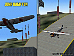
6 different layers in one pack. This scenery pack is a fun experiment in Jump Ramp development - to get aircraft to launch into the air.
Many different angles and many different challenges for your fun flying pleasure.
Contains lots of small and large Jump Ramps, a couple of Ski Ramps and a Grass up/down Hill Runway.
Also contains an Aircraft Carrier with two jump ramps and an Airship with a runway and jump ramp on top.
All set up on 6 different height levels - absolute fun flying and some great challenges for takeoff and landings.
BONUS AIRFIELDS
For those that already have Ford-Blackhawk, Ford-Brazil and Ford-Switzerland installed - a collection of files are included in the Ford-Timor project that will add ramps and jumps to these packages.
Slideshow to show you what is included:
http://www.ford-tri-motor.net/Slideshows/JUMP_RAMP_HEAVEN.html
| Filename: | FordTimor_Jump_Ramp_Heaven.zip |
| License: | Freeware, limited distribution |
| Added: | 16th July 2016, 14:34:48 |
| Downloads: | 79 |
| Author: | Garry J. Smith - Ford Project Team |
| Size: | 3.91 MB |
| Category: Flight Simulator 2004 - Scenery | |
| IONE, Washington - S23 - Airport and adjacent scenery |
|
Images related to this file:
File Description:
Ione is a small airport close to the Washington-Canadian border, about 60 nm North of KSFF (Felts). The ICAO code S23. It now has NDB and VOR; frequencies for these are NDB- 379, VOR-113.20. This airport is an enhanced version of the default S23. It handles small AC only. This is for FS9.
This project started out as an enhancement for my ski-patrol bro who lives in Ione and grew into a major project. This project has four, basic major parts -
1. the airport itself.
2. back road area with a few farm houses, gas station and church.
3. small town - courtesy of Opa Marshall who spent much time with me on suggestions and guidance.
4. Camp ground area.
We hope you will enjoy this work. Readme file has contact info and airport ID of some close by airports. Bob
| Filename: | IONE_Washington__S23__Airport_and_adjacent_scenery.zip |
| License: | Freeware |
| Added: | 2nd February 2010, 10:19:49 |
| Downloads: | 1,331 |
| Author: | Robert Lacy & David "Opa" Marshall |
| Size: | 2.06 MB |
| Category: Flight Simulator 2004 - Scenery | |
| Canadian and Northern USA Winter Flying |
|
File Description:
This is an expanded version of a previous post a year ago, and stretches from east of Quebec City through Quebec, Ontario, and Manitoba, and now also through Saskatchewan, and into Alberta (past Calgary). There is also a northern area roughly centered on Hudson Bay. The exact coverages are given in the notes. All rivers and lakes within the area will "freeze" and allow ski planes to land, or even wheeled planes come to that. And it is not permanent, when you want to go back to floats just "untick" it in the FS library, and it will melt. The area covered crosses into the US too, down to around 45 degrees north, so that means most of Montana, all of North Dakota, half of Minnesota, and some of Wisconsin, Michigan etc. It seemed silly to stop at the border. Ultimate Terrain is highly recommended, so that there will actually be the right lakes and rivers ready to freeze.
| Filename: | Canadian_and_Northern_USA_Winter_Flying.zip |
| License: | Freeware |
| Added: | 26th May 2008, 13:24:29 |
| Downloads: | 669 |
| Author: | Roger Wensley |
| Size: | 354.86 KB |
| Category: Flight Simulator 2004 - Scenery | |
| Clinton Point CWCP, Horton River CWHR & Keats Point CWKP; DEW sites in Northwest Territories, Canada |
|
Images related to this file:
File Description:
These are three DEW line sites in northern mainland Canada, to the east of Tuktoyaktuk.
Clinton Point is almost 300 miles east of Tuktoyaktuk and on the Northwest Territories and Nunavut border. It is the site of a closed DEW station (closed in 1993) and all the buildings have been removed, unlike many other sites where buildings are still almost complete. The roads and the gravel runway down by the beach are still there.
Horton River is 150 miles east of Tuktoyaktuk, up on higher land above the cliffs at around 500 feet ASL. The NWS (North Warning System) replaced the I site which was there previously and which ceased operations in 1963. The NWS is serviced by helicopter from a barge 400 yards away on the beach.
Keats Point is 270 miles east of Tuktoyaktuk, 7 miles from the coast but significantly close to a lake, which was probably used for float plane delivery in the summer (or ski plane delivery in the winter) of NWS station elements during construction.
| Filename: | Clinton_Point_CWCP_Horton_River_CWHR__Keats_Point_.zip |
| License: | Freeware, limited distribution |
| Added: | 17th July 2012, 18:57:08 |
| Downloads: | 278 |
| Author: | Roger Wensley |
| Size: | 2.07 MB |
| Category: Flight Simulator 2004 - Scenery | |
| CYQS - St Thomas - Ontario, Canada *V1* |
|
Images related to this file:
File Description:
St Thomas is a town in Ontario around 12 miles south of London and less than 10 miles from the north shore of Lake Erie, with a population of just under 40,000. The airport (actually more of an airfield, as there are no scheduled flights) has three runways typical of an ex-military field, with one remaining hangar from RCAF flight training times in the 1940's, and the east-west runway now extended to just over 5,000 feet. The main presence at CYQS is a company in the crop seeding and spraying business over a wide area of Ontario; as a result there are several AT-802 planes based there which are included here as AI planes and also as parked scenery objects. To the west of the original apron area there are added taxiways to cater for a herd of new individual hangars wearing orange and white uniforms. There is fuel, runway lighting on 09-27, taxiway lights, visitor parking on the edge of the apron, and maintenance companies in the large hangars, plus a flight training group. A small terminal building sits quietly between hangars, waiting. Ditches along the road and around much of the airfield provide separation, which is why the fences are not continuous. I presume that the warning balls on the electricity cables were found to be necessary to persuade pilots not to land there; probably ski planes in winter, they tend to land anywhere so long as it has snow on it. This V1 version includes previous updates.
| Filename: | CYQS__St_Thomas__Ontario_Canada_V1.zip |
| License: | Freeware, limited distribution |
| Added: | 30th August 2015, 02:35:28 |
| Downloads: | 265 |
| Author: | Roger Wensley |
| Size: | 11.13 MB |
| Category: Flight Simulator 2004 - Scenery | |
| PAEN, PAEX, 3AK4, 30AK, 52AK - Alaska, USA |
|
Images related to this file:
File Description:
The town of Kenai is on the east coast of Cook Inlet, 60 miles southwest of Anchorage. The airport is in the northern part of the town, with a runway aligned 1-19, 7,550 feet long and 150 feet wide (with an ILS on 19). A second runway is gravel, 2,000 feet long and for winter use by ski planes. There is also a water runway, and all three are aligned the same and called "1 left-19 right" (the main runway) "1 right-19 left" (gravel) and "1 water-19 water". The taxiways are extensive and designed for a far larger traffic than the airport has today, though even now the airport is fairly busy. In FS9 a water runway for AI cannot work with an ATC control tower; the water part of PAEN has therefore been separated into another call sign PAEX which has ONLY the water runway; the tower will therefore direct the plane that makes contact to use the water runway. The PAEN airport runway has taxiway connections at each end and also two intermediates; at the northern end there are in fact two so a total of 5; B, C, D, E, and F; there is an airport diagram included. GA traffic goes to one of two parking aprons, both at the southern end, and at the far southern end there is the hangar for the Civil Air Patrol. The AI includes aircraft from my previous Alaska posts, as Kenai is where I sent them when they departed from, for instance, Palmer. Airlines and cargo companies that operate from and to Kenai are included in the AI: ERA (which has recently changed it's name), Grant Aviation, Air North, Wings of Alaska, North Star Air, and a small local company Air Supply Alaska, along with Fedex, UPS, Everts, and Northern Air Cargo. There is also GA and float AI. Nearby smaller airfields are included, partly because one of them was dramatically misaligned in FS9.
| Filename: | PAEN_PAEX_3AK4_30AK_52AK___Alaska_USA.zip |
| License: | Freeware, limited distribution |
| Added: | 26th December 2015, 15:33:19 |
| Downloads: | 482 |
| Author: | Roger Wensley |
| Size: | 23.08 MB |
© 2001-2026 AVSIM Online
All Rights Reserved
Privacy Policy |