
Where Flight Simulation Enthusiasts Gather from Around the World!
AVSIM Library - Search Results

| Category: Flight Simulator 2004 - Scenery | |
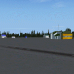
| Kuujjuarapik CYGW in northern Quebec, Canada |

|
Images related to this file:
File Description:
Kuujjuarapik is in northern Quebec at the southern end of Hudson Bay, 90 miles east of James Bay and on the north shore of the Great Whale River; Kuujjuarapik means Small Great River in Inuktitut. Once again the Hudson Bay trading post that opened (in 1820) was the catalyst for the establishment of first a seasonal encampment and then the beginnings of a town in the late 1930's.
The two adjacent villages that now form the town have a total population (mainly Cree and Inuit) of around 1,500. When the Quebec hydo-electric project was under construction in the early 1980's a large portion of the Inuit population voted to move to a new settlement called Umiujaq (my post) 100 miles to the north.
The airport is to the west of the town, between the town and the sea. The gravel and sand runway (which I have made as gravel as there is no convincing way to mix the two) is 5,500 feet long, 150 feet wide, and aligned 17/35, which is approximately parallel to the coast. There is fuel available, both 100LL and JetA, delivered by truck. The AI included here is for Air Inuit and Wasaya, with Air Inuit making three flights per day plus a fourth flight by the Air Inuit Twotter C-GNDO that is based at the airport, and private flights by various aircraft. Yes, there really is a golf course to the south of the airport, and the last thing to note is that Kuujjuarapik has a mandatory radio frequency and that taking into consideration the scheduled flights I have included the tower radio frequency that makes this a controlled airport in FS9.
| Filename: | Kuujjuarapik_CYGW_in_northern_Quebec_Canada.zip |
| License: | Freeware, limited distribution |
| Added: | 16th February 2013, 00:33:20 |
| Downloads: | 299 |
| Author: | Roger Wensley |
| Size: | 2.8 MB |
| Category: Flight Simulator 2004 - Scenery | |
| Bush Flying Unlimited Quebec Scenery Missing Texture Patch 2 |
|
File Description:
I forgot to include the textures for the BFU Quebec sign and the Blue hangar. My apologys. This supercedes the previous patch
I have also included another AFCAD file for the airport as some people have had a problem with the first one.
| Filename: | bfuq_patch_2.zip |
| License: | Freeware, limited distribution |
| Added: | 22nd July 2004, 16:46:35 |
| Downloads: | 3,255 |
| Author: | Brian Gladden |
| Size: | 130 KB |
| Category: Flight Simulator 2004 - Scenery | |
| Montreal Bridges V1.0, Champlain bridge, Montreal, Quebec, Canada. |
|
File Description:
This scenery is the most accurate rendition I could come up with of the CHAMPLAIN BRIDGE and it's ICE BRIDGE, located on the south shore of MONTREAL. It is compatible with FS2004 and FS2002. We plan to add more Montreal bridges in future releases, that's why it is called "Montreal Bridges".
| Filename: | mtl_brdg.zip |
| License: | Freeware |
| Added: | 26th April 2004, 12:38:07 |
| Downloads: | 9,221 |
| Author: | Guy F. Jutras, Quebec Virtual Pilot. |
| Size: | 1.35 MB |
| Category: Flight Simulator 2004 - Scenery | |
| Longue-Pointe de Mingan CYLP, Quebec, Canada |
|
Images related to this file:
File Description:
This scenery represents real the airport of Longue-Pointe of Mingan (CYLP). I carried out this scenery with FSDS. Longue-Pointe of Mingan is localised on northern bank of the St-Laurent river in Quebec, Canada. This scenery is built for both FS-2004 and FS-X.
| Filename: | mingan_cylpv1.zip |
| License: | Freeware |
| Added: | 30th December 2009, 21:28:47 |
| Downloads: | 895 |
| Author: | Regis Dassylva |
| Size: | 9.84 MB |
| Category: Flight Simulator 2004 - Scenery | |
| Montreal Bridges, Mercier Bridge, Montreal, Quebec, Canada. |
|
File Description:
For FS-2002 & 4.
It is imperative to install Gilles Gauthier's MESHes.
library.avsim.net/search.php?CatID=root&SearchTerm=quebec+terrain+mesh&Sort=Added&ScanMode=1&Go=Change+View
What's listed for FS2002 is OK for 2004. NOT reverse.
Hello, Flight 200# Simmers ! Here is a very rough
representation of what that bridge looks like. The kit
will be 2 separate files. Install only ONE, permanently:
MERCIERL.ZIP = for Low end machines, P1200 and less.
MERCIERH.ZIP = for high end machines, LATER...
| Filename: | mercierl.zip |
| License: | Freeware |
| Added: | 6th July 2004, 22:47:37 |
| Downloads: | 2,577 |
| Author: | Jean Morissette |
| Size: | 466 KB |
| Category: Flight Simulator 2004 - Scenery | |
| Havre St-Pierre, Quebec (CYGV) Airport, V1.0 |
|
Images related to this file:
File Description:
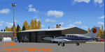
This scenery is a rendition of Havre-St-Pierre (CYGV) airport using GMAX for FS2004.
Information available in the latest official aeronautical publications and
pictures were used as guide in order to reproduce buildings
and other custom 3D objects as accurately as possible.
| Filename: | cygvv10.zip |
| License: | Freeware, limited distribution |
| Added: | 31st October 2009, 10:16:47 |
| Downloads: | 850 |
| Author: | Pierre Gallant |
| Size: | 1.22 MB |
| Category: Flight Simulator 2004 - Scenery | |
| St Andre-Avellin CAA2 in Quebec Canada |
|
Images related to this file:
File Description:
St Andre-Avellin is a new airfield in Quebec Canada, 35 miles east of Ottawa and 10 miles north of the Ottawa River, and just northwest of the village of the same name. There is a 03/21 grass runway that is 2,870 feet long and slopes up towards the north. To show this slope I have not "placed" a grass runway (which would immediately flatten the slope) and anway there is not so much traffic that the grass would be notably marked. Because of the lack of an FS-recognised runway I have not made parking or a traffic file as AI would not work; anyway this airfield with constant activity would not reflect reality. There are no facilities at the airfield except a hangar for the owner and space to park.
| Filename: | st_andre-avellin.zip |
| License: | Freeware, limited distribution |
| Added: | 9th April 2011, 20:49:47 |
| Downloads: | 166 |
| Author: | Roger Wensley |
| Size: | 848 KB |
| Category: Flight Simulator 2004 - Scenery | |
| Waskaganish CYKQ in James Bay, Quebec, Canada |
|
Images related to this file:
File Description:
Waskagansh is a village with 2,500 or so inhabitants at N51 28 W78 45 on the southeast shore of James Bay. It was founded in 1668 as Fort Charles (later it became Fort Rupert) and was the first Hudson's Bay Company trading post in the James Bay area. The village's current name means Little House in the Cree language. The village does not feature in FS9 but is included in this scenery with approximately the right shape; just think of it as a hand-made auto-generated village.
I also had to add the roads (the file called "waskROADS"), delete the stock airfield background ("WaskDELETE"), and add a new background ("WaskGRASS") plus of course there is the usual scenery file and the AFCAD and AI. There is also a note in here on what to do about a possible texture problem for the village that I have discussed with two downloaders and solved. I hope.
| Filename: | waskaganish.zip |
| License: | Freeware, limited distribution |
| Added: | 21st October 2010, 23:32:16 |
| Downloads: | 537 |
| Author: | Roger Wensley |
| Size: | 1.43 MB |
| Category: Flight Simulator 2004 - Scenery | |
| Puvirnituq CYPX in Hudson Bay, Quebec, Canada |
|
Images related to this file:
File Description:
Puvirnituq is a village of 1,300 or so inhabitants at N60 W77 on the east shore of Hudson Bay. It's name means "Putrid" in Inuit, and there are two different stories about how it got the name. The village does not feature in FS9, but is included in this scenery with approximately the right shape (the coast, even with UT, is not exactly right) so just think of it as a hand-made auto-generated village which gives the airfield a reason for being there. The runway is a very generous 6,300 feet of gravel 148 feet wide, which should be enough for almost anything. I also had to add the roads, delete the stock airfield background and add a new background, plus of course there is the scenery file and the AFCAD and AI.
| Filename: | puvirnituq.zip |
| License: | Freeware, limited distribution |
| Added: | 30th October 2010, 13:34:30 |
| Downloads: | 372 |
| Author: | Roger Wensley |
| Size: | 1.78 MB |
| Category: Flight Simulator 2004 - Scenery | |
| Ivujivik CYIK in Hudson Bay, Quebec, Canada |
|
Images related to this file:
File Description:
Ivujivik is a village of 350 or so inhabitants at N62 25 W78 on the northeastern corner of Hudson Bay. The village does not feature in FS9 but is included in this scenery with approximately the right shape (the coast, even with UT, is not exactly right) so just think of it as a hand-made auto-generated village which gives the airfield a reason. The runway is 3,500 feet of gravel 100 feet wide, which should be enough. I also added the roads, deleted the stock airfield background and added a new background, plus of course there is the scenery file and the AFCAD and AI. You may note that the terminal has the elevation written on the sign as 126', while on the winter photo it is written on the older & bigger sign as 130'. I thought this is because satellite radar has fixed the elevations of all airfields more accurately than before, as Rockcliffe too has gone from 192' to 188'; the alternative explanation is that global warming has raised sea level by 4'. Wow! That's a thought. I presume the new sign was made smaller as a cost saving.
| Filename: | ivujivik.zip |
| License: | Freeware, limited distribution |
| Added: | 31st October 2010, 07:41:20 |
| Downloads: | 454 |
| Author: | Roger Wensley |
| Size: | 2.14 MB |
© 2001-2025 AVSIM Online
All Rights Reserved