
Where Flight Simulation Enthusiasts Gather from Around the World!
AVSIM Library - Search Results

| Category: Flight Simulator 2004 - Scenery | |
| LFAT Photosceney |

|
File Description:
LFAT - Le Touquet (France) Airport Photo scenery.
Provides re-mesh, full customized autogen, and specific 3D objects.
Seasonal and night textures are on the way for future upgrade.
| Filename: | lfat.zip |
| License: | Freeware, limited distribution |
| Added: | 25th November 2006, 20:45:30 |
| Downloads: | 4,852 |
| Author: | Alain Nicco & Thomas Philibert |
| Size: | 5.78 MB |
| Category: Flight Simulator 2004 - Scenery | |
| Imperial War Museum, Duxford |
|
Images related to this file:
File Description:

IWM Duxford, UK. Just about the definitive representation of the Imperial War Museum, Duxford you could wish for.
Includes comprehensive photo-realistic buildings and structures on both the north and south sides of the airfield, photo ground tiles and it is fully customisable from a quite day through to an optional air show add-on. Complete with a package of 20 custom built classic AI aircraft. By Airfield Construction Group (ACG).
| Filename: | acg_iwm_duxford_fs9.zip |
| License: | Freeware, limited distribution |
| Added: | 5th November 2011, 19:56:08 |
| Downloads: | 5,045 |
| Author: | John Young, Stephen Legg, ACG |
| Size: | 59.02 MB |
| Category: Flight Simulator 2004 - Scenery | |
| Kanab (KKNB), Utah/Arizona, Photo-Scenery (FS9 & FSX) |
|
Images related to this file:
File Description:
This scenery covers the southwestern part of Grand Staircase-Escalante National Monument. From the air
you can see all the "stairs" from the Pink Cliffs of Bryce Canyon in the north down to the Grey Cliffs,
the White Cliffs and the Vermillion Cliffs just north of Kanab and then the Chocolate Cliffs further south.
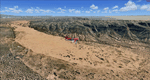
Nothwest of Kanab you can fly above beautiful Coral Pink Sand Dunes State Park which features coral-hued
sand dunes located beside red sandstone cliffs. These dunes consist of sand that formed thru erosion of
pink colored Navajo Sandstone surrounding the park and was deposited by wind. To explore the scenery depart
from Kanab Airport (KKNB).
High resolution versions of this scenery for FS9 and FSX (much sharper, but larger and multiple downloads)
are available at www.blueskyscenery.com/CNY_South3West4.html . The screenies are taken from the high-res versions,
so expect this version to be slightly more blurry. Thanks to Joop Mak for providing custom AFCADs that
correct airport layouts so that they align with the photo-textures! They are available at
www.blueskyscenery.com/AFCADs.html . YourDonation@Work: Dedicated to Jesper, Fabrizio and Glen.
| Filename: | cny_south3west4_2010_lr.zip |
| License: | Freeware, limited distribution |
| Added: | 10th March 2010, 22:24:53 |
| Downloads: | 1,500 |
| Author: | Gottfried Razek - blueskyscenery.com |
| Size: | 95.36 MB |
| Category: Flight Simulator 2004 - Scenery | |
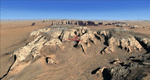
| Bryce Canyon National Park (KBCE), Utah, Photo-Scenery |
|
Images related to this file:
File Description:
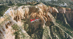
Bryce Canyon National Park (KBCE), Utah, Photo-Scenery (FS9 & FSX)
Despite its name, Bryce Canyon is not actually a canyon that was formed by a river, but rather a giant natural cliff shaped through erosion by wind, water, and ice. Bryce is distinctive due to its geological formations, delicate and colorful pinnacles called hoodoos that are up to 200ft high. The bizarre forms and red, orange and white colors of the rocks provide spectacular views. Unfortunately the hoodoos are too small for the elevation mesh in flight simulator. But you can enjoy the colors and shape of the cliffs. The cliffs in main region of the park, just south of the airport are partly covered
by snow. But on the southern and western part of the plateau you can enjoy them free of snow. Bryce Canyon is named after the Mormon pioneer Ebenezer Bryce who settled in this area in the 1850s. It was designated as a national park in 1928.
Bryce Canyon Airport (KBCE) just handles small aircraft on a daily basis. But is was actually built to handle larger aircraft in case of emergency. And so on Oct.6th 2000 an American Airlines MD-82 from Denver to Los Angeles made a successful emergency landing after reporting smoke in the cockpit and a loss of cabin pressure.
High resolution versions of this scenery for FS9 and FSX (much sharper, but larger and multiple downloads)are available at www.blueskyscenery.com/CNY_South2West4.html . The screenies are taken from the high-res versions, so expect this version to be slightly more blurry. Thanks to Joop Mak for providing a custom AFCADs that correct airport layouts so that they align with the photo-textures! They are available here: www.blueskyscenery.com/AFCADs.html . YourDonation@Work: Dedicated to Michael, Pat and Keith.
| Filename: | cny_south2west4_2010_lr.zip |
| License: | Freeware, limited distribution |
| Added: | 7th March 2010, 11:17:56 |
| Downloads: | 2,193 |
| Author: | Gottfried Razek, blueskyscenery.com |
| Size: | 96.35 MB |
| Category: Flight Simulator 2004 - Scenery | |
| Mormon Range, Enterprise, Beryl (UT82), Utah, Photo-Scenery |
|
Images related to this file:
File Description:
Mormon Range, Enterprise, Beryl (UT82), Utah, Photo-Scenery (FS9 & FSX)
This scenery covers the area of just north of St. George (KSGU) north along the Mormon Range and Enterprise to Beryl (UT82). It completes the southwestern corner of Utah and paves our way into Nevada. High resolution versions of this scenery for FS9 and FSX (much sharper, but larger and multiple downloads)are available at www.blueskyscenery.com/CNY_South2West6.html . The screenies are taken from the high-res versions, so expect this version to be slightly more blurry.
Thanks to Joop Mak for providing a custom AFCADs that correct airport layouts so that they align with the photo-textures! They are available at www.blueskyscenery.com/AFCADs.html . YourDonation@Work: Dedicated to Jean Pierre, Konrad and Juan.
| Filename: | cny_south2west6_2010_lr.zip |
| License: | Freeware, limited distribution |
| Added: | 27th March 2010, 11:38:48 |
| Downloads: | 1,357 |
| Author: | Gottfried Razek, blueskyscenery.com |
| Size: | 97.45 MB |
| Category: Flight Simulator 2004 - Scenery | |
| Colorado Springs North, Colorado, Photo-Scenery (FS9 & FSX) |
|
Images related to this file:
File Description:
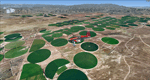
This region covers the area between Denver and Colorado Springs. It extends my Denver scenery to the south.
Just north of Colorado Springs you can see the widespread United States Air Force Academy which, with it's
many buildings, covers a huge area of 18.000 acres. The Academy Airfield (KAFF) which lays in the northeastern
corner of the area is used for training cadets in airmanship courses, including parachute training,
soaring and powered flight.
High resolution versions of this scenery for FS9 and FSX (much sharper, but larger and multiple downloads)
are available at www.blueskyscenery.com/GNB_South2East.html . The screenies are taken from the high-res versions,
so expect this version to be slightly more blurry. YourDonation@Work: Dedicated to Robin and Raymond.
| Filename: | gnb_south2east_2010_lr.zip |
| License: | Freeware, limited distribution |
| Added: | 3rd February 2010, 02:09:59 |
| Downloads: | 2,175 |
| Author: | Gottfried Razek - blueskyscenery.com |
| Size: | 96.92 MB |
| Category: Flight Simulator 2004 - Scenery | |
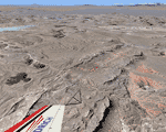
| Monument Valley, Kayenta (0V7), Utah/Arizona, Photo-Scenery |
|
Images related to this file:
File Description:
Monument Valley, Kayenta (0V7), Utah/Arizona, Photo-Scenery (FS9 & FSX)
This scenery covers the area from south of the San Juan River down to wonderful Monument Valley and Kayenta, AZ.
It extends my Lake Powell sceneries to the south and brings you another
3.500 sq km in 4.7m/pix quality. To explore the scenery depart from Kayenta (0V7) and head north.
High resolution versions of this scenery for FS9 and FSX (much sharper, but larger and multiple downloads) are available at www.blueskyscenery.com/CNY_South3West.html . The screenies are taken from the high-res versions, so expect this version to be slightly more blurry. YourDonation@Work: Dedicated to Thomas, Don and Eric.
| Filename: | cny_south3west_2010_lr.zip |
| License: | Freeware, limited distribution |
| Added: | 23rd January 2010, 10:45:32 |
| Downloads: | 2,261 |
| Author: | Gottfried Razek - blueskyscenery.com |
| Size: | 93.49 MB |
| Category: Flight Simulator 2004 - Scenery | |
| Las Vegas (KLAS), Nevada, Photo Scenery (FSX too) |
|
Images related to this file:
File Description:
This package contains photo-scenery for the greater area of Las Vegas, covering an area of 3.250 sq km and is dedicated to the donators Donald, John and David. The scenery reaches from the foothills of Mt. Charleston to Lake Mead (partly covered). The quality is in standard FS2004-resolution of 4.7m/pixel. It works equally well in FS2004 and FSX. Hi-Res overlays fill follow. For a complete list of available titles please visit us at www.blueskyscenery.com
| Filename: | las2007_lr.zip |
| License: | Freeware, limited distribution |
| Added: | 30th December 2009, 18:01:52 |
| Downloads: | 10,830 |
| Author: | Gottfried Razek - blueskyscenery.com |
| Size: | 80.59 MB |
| Category: Flight Simulator 2004 - Scenery | |
| Hong Kong VFR v.0.5 Alpha (Photo Scenery) |
|
Images related to this file:
File Description:
This is a photo scenery of Hong Kong in alpha stage which was finished in 2010. The scenery is just similar with Project Visual Hong Kong but with accurate coordinates. The scenery covers a part of Shenzhen and most part of Hong Kong (Except the North East Part of Hong Kong). Terrain mesh is included.
| Filename: | hkvfr_v0.5a.zip |
| License: | Freeware |
| Added: | 9th October 2011, 20:36:38 |
| Downloads: | 1,802 |
| Author: | Thomas Lau |
| Size: | 51.21 MB |
| Category: Flight Simulator 2004 - Scenery | |
| FAGR Graaff Reinet Airport, South Africa |
|
File Description:
Graaff Reinet Airport (FAGR), South Africa.
Detailed airport scenery, containing photo realistic hangars and buildings.
| Filename: | fs9fagr.zip |
| License: | Freeware, limited distribution |
| Added: | 26th December 2012, 19:20:50 |
| Downloads: | 807 |
| Author: | Johan van Wyk, Aeroworx |
| Size: | 2.82 MB |
© 2001-2025 AVSIM Online
All Rights Reserved