
Where Flight Simulation Enthusiasts Gather from Around the World!
AVSIM Library - Search Results

| Category: Flight Simulator 2004 - Scenery | |
| Ascension Island Landclass Update |

|
File Description:
Updated Ascension Island Landclass. Rids Ascension of its green jungle look, and adds lava rock in its place. Only greenery is atop Green Mtn. where it actually exists. Works great and highly recommended with John Holden's mesh scenery (southatlantic.zip) Tested in FS2004 and FSX.
| Filename: | Ascension_Island_Landclass_Update.zip |
| License: | Freeware |
| Added: | 20th February 2008, 00:59:32 |
| Downloads: | 2,263 |
| Author: | Scott Wilson |
| Size: | 140.44 KB |
| Category: Flight Simulator 2004 - Scenery | |
| Fort Fisher - Kure Beach Long Range Radar Complex |
|
File Description:
Today we are at the beach! Well, almost. The Fort Fisher - Kure Beach LRR [QGV] sits on a slight hill just 15 ft above the blue Atlantic. Just 1,500 feet to your east the surf is rolling up onto Kure Beach. This part of southern North Carolina is beautiful, and I suspect quite crowded with sun worshippers when the weather is appropriate. Start from Wilmington International [KILM] and wander 17 nm down the peninsula to the site. A helipad and terminal VOR [108.00] are included in the scenery. Scenery sets are provided for the FSGenesis 38m terrain mesh, and the standard fs9 terrain mesh.
| Filename: | Fort_Fisher__Kure_Beach_Long_Range_Radar_Complex.zip |
| License: | Freeware |
| Added: | 14th November 2007, 21:33:29 |
| Downloads: | 496 |
| Author: | Brett Delana |
| Size: | 292.64 KB |
| Category: Flight Simulator 2004 - Scenery | |
| Colombian Airports Part 2 |
|
File Description:
This is an addition to my previous Colombian Airports uploads (colapts1.zip, colapts2.zip, colapts3.zip). Part 2 adds the following airports: SKAS, SKAP, SKBM, SKCR, SKCV, SKGA, SKGI, SKHA, SKIM, SKIO, SKIR, SKLB, SKLM, SKLP, SKMF, SKOE, SKSA, SKSV, SKTQ, SKTR, SKUM, SKVN, SKVV, Z08W, Puerto Arica (IATA: ACM), La Loma East and West (SKL1).
It is for FS9 default scenery and the Colombia freeware mesh by Raimondo Taburet. However, the scenery should also work with the default or any other mesh but I have not tested it. Requires previous installation of "colapts1.zip" and "colapts3.zip". "colapts2.zip" is required only for the rwy12 and ez-objects libraries used.
| Filename: | Colombian_Airports_Part_2.zip |
| License: | Freeware |
| Added: | 7th June 2015, 10:26:39 |
| Downloads: | 1,202 |
| Author: | Detlev J. Rohmer |
| Size: | 51.37 MB |
| Category: Flight Simulator 2004 - Scenery | |
| Hricziscse Ranch, Oregon v2 |
|
File Description:
A small mixup resulted in a couple incorrect files for a short time in previous version. Check inside folder "FS9 Default Mesh" for bgl files "hricz.bgl" and "hricz_A16N.bgl". They should be dated 4/28/2004. If you have the earlier dated version then you will want to download this fixed version. Sorry for the inconvenience.--------------------------
A simulation of the real-world 483 acre Hricziscse Ranch located in Langell Valley, southeast Oregon, 21nm east of KLMT. Of course, I don't really have an airstrip, but it would be neat. Landclass also used to more closely depict the agricultural nature of the valley. Some artistic leeway is used in the depiction of the ranch and its surroundings. It's a lot cleaner (sterile) in FS than real-life. Rwy 29/11_1500' x 50' grass_alt 4211.3'_night lighting (airstrip does not exist in real world). This scenery is a bit of a frame-hog. --This scenery is designed for use with FSGenesis Westcoast mesh. Alternate files provided for FS9 default mesh users. See install readme for options--
| Filename: | Hricziscse_Ranch_Oregon_v2.zip |
| License: | Freeware, limited distribution |
| Added: | 1st May 2004, 01:42:15 |
| Downloads: | 1,116 |
| Author: | Brent Hricziscse |
| Size: | 7.24 MB |
| Category: Flight Simulator 2004 - Scenery | |
| Joshua Tree + San Bernardino Mountains, California 38m Terrain Mesh |
|
File Description:
USGS SRTM30 1 arc-second, resampled to LOD10 (38.2 meters). This terrain mesh is centered at Joshua Tree National Park in southern California. Coverage area: From West 115.1° to West 117.4° and North 33.7° to North 34.3°. It includes the National Park, the Palm Springs area with Mount San Jacinto and the San Bernardino Mountains.
| Filename: | Joshua_Tree__San_Bernardino_Mountains_California_3.zip |
| License: | Freeware, limited distribution |
| Added: | 4th January 2004, 21:05:58 |
| Downloads: | 3,714 |
| Author: | Andreas Trawny |
| Size: | 4.57 MB |
| Category: Flight Simulator 2004 - Scenery | |
| Guadalupe Mountains National Park (Version 2) SRTM30_1ArcSec Terrain Mesh |
|
File Description:
This 38m terrain mesh is centered in the 'Panhandle' region of Western Texas.
Coverage area: From West 104.5° to West 105° and North 31.7° to North 32.2°.
It includes Guadalupe Mountains National Park and the surrounding mountains
of Lincoln National Forest. Version 2 replaces my former release of 'Guadalupe_Mountains_SRTM30.zip' which covered a too large area and had some scenery anomalies (craters). The new version now fixes these errors.
| Filename: | Guadalupe_Mountains_National_Park_Version_2_SRTM30.zip |
| License: | Freeware, limited distribution |
| Added: | 28th December 2003, 18:33:52 |
| Downloads: | 2,062 |
| Author: | Andreas Trawny |
| Size: | 1.27 MB |
| Category: Flight Simulator 2004 - Scenery | |
| Backcountry USFS fields for 19m terrain mesh in Idaho |
|
Images related to this file:
File Description:
These backcountry airfields are for use with the FSGenesis 19m mesh of Idaho; they almost certainly do not work without it. I also have Ultimate Terrain installed, with the settings as noted. The 15 airfields included here are almost all United States Forestry Service fields: 1U1 Moose Creek, 2ID7 Cayuse Creek, 2U5 Shearer, 3U1 Warren, 12ID Flying B Ranch, 24K Krassel, 75c Orogrande, I08 Cabin Creek, ID67 Lower Loon Creek, ID76 Wilson Bar, S81 Indian Creek, S92 Fish Lake, U54 Bernard, U79 Chamberlain, U81 Cold Meadows. There is also a 85U bgl included to remove the remnants of Soldier Bar which is impossible to make into a scenery with the terrain mesh, and spoiled the surroundings if left untouched and intact. The screenshots are typical examples giving a good impression of the terrain.
| Filename: | Backcountry_USFS_fields_for_19m_terrain_mesh_in_Id.zip |
| License: | Freeware, limited distribution |
| Added: | 22nd July 2019, 16:38:48 |
| Downloads: | 100 |
| Author: | Roger Wensley |
| Size: | 22.2 MB |
| Category: Flight Simulator 2004 - Scenery | |
| Central Volcanic Belt, Mexico 76m SRTM Terrain Mesh & Landclass |
|
File Description:
USGS SRTM 3 arc-second, resampled to LOD9 (76 meters). This is a terrain mesh & landclass scenery of the Central Volcanic Belt in Mexico. The following volcanoes can be found in this area: Popocatepetl, Iztaccihuatl, La Malinche, Pico de Orizaba and Cofre de Perote. Also included are some volcanic eruption effects.
| Filename: | Central_Volcanic_Belt_Mexico_76m_SRTM_Terrain_Mesh.zip |
| License: | Freeware, limited distribution |
| Added: | 11th April 2004, 06:32:55 |
| Downloads: | 7,627 |
| Author: | Andreas Trawny |
| Size: | 2.9 MB |
| Category: Flight Simulator 2004 - Scenery | |
| Azores Islands, North Atlantic Ocean 76m SRTM Terrain Mesh |
|
File Description:
USGS SRTM 3 arc-second, resampled to LOD9 (76 meters). This is a terrain mesh scenery of the Azores Islands in the North Atlantic Ocean. It includes the following islands: Flores, Corvo, Faial, Pico with 7,711 feet (2,351m) high Pico Volcano, Sao Jorge, Graciosa, Terceira, Sao Miguel and Santa Maria.
| Filename: | Azores_Islands_North_Atlantic_Ocean_76m_SRTM_Terra.zip |
| License: | Freeware, limited distribution |
| Added: | 8th April 2004, 03:20:23 |
| Downloads: | 7,985 |
| Author: | Andreas Trawny |
| Size: | 1.81 MB |
| Category: Flight Simulator 2004 - Scenery | |
| Pudding Hill - NZPH |
|
Images related to this file:
File Description:
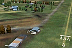
44nm east from Christchurch, New Zealand. 22nm from Ashburton.
Pudding Hill Lodge and Holiday Park. Skydiving area. Choice of 2 runways. Made for Christian Stock's NZ mesh in the form of "Mountains of New Zealand" and topo in the form of "Lakes and Rivers of New Zealand".
| Filename: | Pudding_Hill__NZPH.zip |
| License: | Freeware |
| Added: | 2nd January 2011, 21:56:28 |
| Downloads: | 285 |
| Author: | Godfrey Tier |
| Size: | 1.15 MB |
© 2001-2026 AVSIM Online
All Rights Reserved
Privacy Policy |