
Where Flight Simulation Enthusiasts Gather from Around the World!
AVSIM Library - Search Results

| Category: Flight Simulator 2004 - Scenery | |
| Brevoort CWOB and BAF-3 radar plus Cartwright LAB-6 radar Canada |

|
Images related to this file:
File Description:
Brevoort airstrip and the BAF-3 radar it serves is on Brevoort Island, off one of the southeastern tips of Baffin Island and 140 miles east of Iqaluit. This scenery includes the BAF-3 buildings on the hilltop and those on the airstrip below, plus the roads connecting them and down to the beach landing area on the rocky coast. This scenery is made for the FSGenesis 76m terrain mesh for northern Canada, and there will be a repost of all my northern Canada airfields to suit this; I cannot think now why I never installed this mesh before. The AI reflects the use of civil airlines for resupply and transportation of personnel. Given the terrain the wind should be from the north so that ai lands using the 02 runway. Landing from the north will involve a terrain clash while take off towards the north will not as the climb out clears the hilltop. The video shows the 600 foot cliff at the runway threshold and an Air Tindi plane on the apron. Cartwright CYCA is on the Labrador coast and has been posted by Flight Ontario as part of their Goose Bay and Labrador Regional Airports sceneries. The nearby LAB-6 radar site is included here, connected to CYCA by an extended road. The site uses the same buildings as Brevoort and Saglek (posted recently) and although I have included them here as separate sceneries the contents can be placed in the same folders as Saglek with a saving in duplicated textures. The textures here are more accurate than Saglek so say yes to over-write; a downloader with personal experience of Brevoort noted that in reality they are lighter.
| Filename: | Brevoort_CWOB_and_BAF3_radar_plus_Cartwright_LAB6_.zip |
| License: | Freeware, limited distribution |
| Added: | 20th August 2017, 15:46:36 |
| Downloads: | 177 |
| Author: | Roger Wensley |
| Size: | 4.37 MB |
| Category: Flight Simulator 2004 - Scenery | |
| High Canyon Camp |
|
File Description:
This little camp in the Ketchikan, Alaska area is part of a group of fictional sceneries covering Southeast AK. Should work fine with or without Eddy Denny's terrain mesh. I hope you enjoy them as much as I have.
Menu entries on the Add-on Scenery menu will get you to the starting points. Requires trees_v3 from Garrish Gray. Includes a short dirt strip, STOL planes only need apply. It makes for a nice hop from Ketchikan, AK, and due its proximity to Moudi Farm (Najis Bush Scenery), is a good weekend camping spot for farm residents and visitors. The old cabin is boarded up and has fallen into disuse, but the landing strip is in pretty good shape, and you will usually (okay always) find campers there. Fly on in, I'm sure you'll be welcome.
| Filename: | High_Canyon_Camp.zip |
| License: | Freeware |
| Added: | 16th January 2004, 21:11:31 |
| Downloads: | 1,629 |
| Author: | Todd Hudgel |
| Size: | 980.46 KB |
| Category: Flight Simulator 2004 - Scenery | |
| EPGD 2008 - Gdansk Lech Walesa Airport, Poland |
|
Images related to this file:
File Description:

Gdansk Lech Walesa Airport (EPGD) is an international airport located in Gdansk, Poland, not far from the city centers of the Tricity metropolitan area: Gdansk (6.25 miles/10 km), Sopot (6.25 miles/10 km) and Gdynia (14.4 miles/23 km). The airport is named after Lech Walesa, the former Polish president. On the outside wall of the terminal building one can see the logo of the airport, which is Lech Walesa's actual signature, a stylized "W".
EPGD 2008 is the first Polish scenery in this quality. Main features of the scenery are:
-Airport ground high resolution textures - (five seasons + night textures);
-Highly detailed 3D objects, all photo textured;
-Animation vehicles ground services;
-Detailed autogen and photorealistic trees;
-Detail mesh.
For more details please look at the README file attached to the scenery file.
| Filename: | EPGD_2008__Gdansk_Lech_Walesa_Airport_Poland.zip |
| License: | Freeware |
| Added: | 18th May 2010, 10:37:46 |
| Downloads: | 25,750 |
| Author: | Kuba Paczek |
| Size: | 24.06 MB |
| Category: Flight Simulator 2004 - Scenery | |
| Modified SRTM Relief 76 m for Czech Republic |
|
File Description:
This Czech Republic terrain mesh 76 m (LOD9) is made from the 3arc-sec SRTM. Small voids in the source data were filled by the interpolation. Both the primary processing of the 3arc-sec data and the rendering of the terrain in the FS cause flattening and simplifying of the real shape of the terrain. This phenomenon was partially compensated by the sharpening of the source data. Made by the programs Surfer (Golden Software) and MS Terrain SDK 2000 and 2002. The relief covers the area N51.1523 E011.9531 to N48.5156 E018.9844 in the boundaries of the LOD9 quadrants. This scenery contains only the elevation data. The other elements of the basic terrain as the landclass, locally used airborne photos, vector roads, rivers and lakes are available in different sceneries by other authors and they are continuously developed.
| Filename: | Modified_SRTM_Relief_76_m_for_Czech_Republic.zip |
| License: | Freeware |
| Added: | 22nd December 2003, 21:25:07 |
| Downloads: | 6,723 |
| Author: | Vladimir Stoje |
| Size: | 20.81 MB |
| Category: Flight Simulator 2004 - Scenery | |
| Modified SRTM relief 76 m for Slovakia |
|
File Description:
This Slovak terrain mesh 76 m (LOD9) is made from the 3arc-sec SRTM. The voids in the source data were filled by the interpolation. Both the primary processing of the 3arc-sec data and the rendering of the terrain in the FS cause flattening and simplifying of the real shape of the terrain. This phenomenon was partially compensated by the sharpening of the source data.
Made by the programs Surfer (Golden Software) and MS Terrain SDK 2000 and 2002. The relief covers the area N49.9219 E016.1719 to N47.4609 E022.9687 in the boundaries of the LOD9 quadrants. This scenery contains only the elevation data. The other elements of the basic terrain as the landclass, locally used airborne photos, vector roads, rivers and lakes are available in different sceneries by other authors and they are continuously developed.
| Filename: | Modified_SRTM_relief_76_m_for_Slovakia.zip |
| License: | Freeware, limited distribution |
| Added: | 28th May 2010, 19:40:13 |
| Downloads: | 4,609 |
| Author: | Vladimir Stoje |
| Size: | 19.36 MB |
| Category: Flight Simulator 2004 - Scenery | |
| KCRW - Charleston-Yeager 2014 |
|
Images related to this file:
File Description:
Yeager Airport KCRW in Charleston, West Virginia, is a mid-size airport surrounded by beautiful terrain (see the section on Optional Mesh). The terminal can easily accommodate 737 class airliners as well as commuter turboprops, and there are GA and West Virginia National Guard ramps. This scenery reflects the current single runway configuration, the former second runway having been converted into taxiway C. It is a complete rebuild with all custom buildings and some photo ground textures. I have also redone the instrument approaches to match the current real ones, and they will automatically be listed and displayed on your GPS. Instrument Approach Plates are included.
This work is entirely my own, but I would like to thank Brandon DePalo for his very well done earlier version of KCRW. Without that, I would not have known about this airport.
| Filename: | KCRW__CharlestonYeager_2014.zip |
| License: | Freeware |
| Added: | 26th April 2014, 07:05:30 |
| Downloads: | 648 |
| Author: | Sidney Schwartz |
| Size: | 7.29 MB |
| Category: Flight Simulator 2004 - Scenery | |
| Argyle International Airport, Saint Vincent |
|
Images related to this file:
File Description:
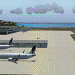
This is a scenery created by me of the soon to be completed Argyle International Airport on the island nation of Saint Vincent and the Grenadines. This scenery was created as a pet project of mine out of personal love for the project. The airport was created using only default scenery objects and the only thing that was changed was the type and direction of the turning point at the RWY04 end. I'm sharing this so FS2004 simmers can see what the airport will be like on completion. The scenery is 100% customizable to suit your preference. All I ask is that you don't change the actual airport design. I hope that this will bring you hours and hours of flying fun.
Important: This scenery requires the full RWY12 Scenery Library including the Gate Markings SS files. Also the Lesser Antilles Mesh is required.
| Filename: | Argyle_International_Airport_Saint_Vincent.zip |
| License: | Freeware |
| Added: | 22nd December 2013, 21:57:40 |
| Downloads: | 529 |
| Author: | Cilbert Campbell |
| Size: | 6.8 KB |
| Category: Flight Simulator 2004 - Scenery | |
| Kerkira Airport Enhancement |
|
File Description:
This is old scenery which has been updated for FS2004 and enhances the visual environment of Ionian sea island airport of Kerkira, also known as Corfu. Its part of my “Greek Airfields” package that currently is not fully compatible with FS2004 since MS decided to move the airports in Greece and elsewhere to adjacent positions and ASD, which I use for placing these objects, is not compatible with FS2004. Here you will find airport & terrain enhancements for Hellenic airport of Kerkira LGKR that make it look closer to the real one; hotels, runway turning bay, perimeter fences, windsocks, radio antennae, new approach radar antenna to the southwest and most importantly, an exclusion of autogen scenery that is wrongfully generated on each side of the runway. A big difference is attributed to Babis Peribolas’s Kerkira mesh terrain that is included in this scenery. Scenery includes the necessary ASD 2.1 textures.
| Filename: | Kerkira_Airport_Enhancement.zip |
| License: | Freeware, limited distribution |
| Added: | 4th September 2003, 02:23:06 |
| Downloads: | 12,182 |
| Author: | Kyprianos Biris |
| Size: | 1.94 MB |
| Category: Flight Simulator 2004 - Scenery | |
| The Victoria Falls of the Zambezi River, Zambia/Zimbabwe |
|
File Description:
One of the main landmarks of Africa, the spectacular Victoria Falls of the Zambezi River are missing in out-of-the-box FS. With a local SRTM LOD9 mesh as a base (included) and the help of satellite imagery, maps, Ground2K4, and GMax, we did our best to model a realistic representation of the falls, the river, and the gorge, complete with custom waterfall and spray effects. The portion of the Zambezi covered in this project extends from E25 to E26.5 (more than 100km), with the falls at its center. Also included is a replacement landclass file for an area of about 20km on either side of the Zambezi River and an optional AI boat (by Lynn and Bill Lyons) cruising on the Zambezi above the falls. Tested with FS2004 only but most scenery enhancements (not the AI boat) should work just as well in FS2002.
| Filename: | The_Victoria_Falls_of_the_Zambezi_River_ZambiaZimb.zip |
| License: | Freeware, limited distribution |
| Added: | 8th May 2004, 02:45:30 |
| Downloads: | 19,147 |
| Author: | Holger Sandmann and Johan van Wyk, Aeroworx |
| Size: | 3.5 MB |
| Category: Flight Simulator 2004 - Scenery | |
| BFU Brooks |
|
File Description:
With BFU Brooks, BFU enters the faraway bush country of northern Alaska. Located at Coldfoot in the southern foothills of the Brooks mountains, this base will cater to the needs of visitors to the area, and of sportsmen who indulge in hunting and fishing. This scenery package consists of three sceneries: our new northern base BFU Brooks, Moose Camp and Moose Lodge. The camp sits in the mountains on a small lake, whereas the lodge is situated on the shore of a large lake. Visitors are flown into Coldfoot from Fairbanks, then on to the camp or lodge as desired. Moose Camp and Moose Lodge will not show on the GPS, and of course do not have an NDB or similar to guide you. You'd better start in the camp/lodge, and fly toward Coldfoot to get to know the area. The sceneries have only been tested with the default mesh.
| Filename: | BFU_Brooks.zip |
| License: | Freeware |
| Added: | 30th September 2003, 15:17:31 |
| Downloads: | 5,318 |
| Author: | Naji Chehabeddine |
| Size: | 2.96 MB |


© 2001-2026 AVSIM Online
All Rights Reserved
Privacy Policy |