
Where Flight Simulation Enthusiasts Gather from Around the World!
AVSIM Library - Search Results

| Category: Flight Simulator 2004 - Scenery | |
| Ford-Timor (Jump Ramp Heaven) |

|
Images related to this file:
File Description:
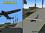
6 different layers in one pack. This scenery pack is a fun experiment in Jump Ramp development - to get aircraft to launch into the air.
Many different angles and many different challenges for your fun flying pleasure.
Contains lots of small and large Jump Ramps, a couple of Ski Ramps and a Grass up/down Hill Runway.
Also contains an Aircraft Carrier with two jump ramps and an Airship with a runway and jump ramp on top.
All set up on 6 different height levels - absolute fun flying and some great challenges for takeoff and landings.
BONUS AIRFIELDS
For those that already have Ford-Blackhawk, Ford-Brazil and Ford-Switzerland installed - a collection of files are included in the Ford-Timor project that will add ramps and jumps to these packages.
Slideshow to show you what is included:
http://www.ford-tri-motor.net/Slideshows/JUMP_RAMP_HEAVEN.html
| Filename: | FordTimor_Jump_Ramp_Heaven.zip |
| License: | Freeware, limited distribution |
| Added: | 16th July 2016, 14:34:48 |
| Downloads: | 80 |
| Author: | Garry J. Smith - Ford Project Team |
| Size: | 3.91 MB |
| Category: Flight Simulator 2004 - Scenery | |
| Repost of Dryden Regional CYHD in Ontario Canada |
|
File Description:
This repost is first to deal with some lighting problems on the runways (though I still couldn't get rid of the taxiway lights that head off across the grass) and also to provide the right AFCAD file.
Dryden is in northwest Ontario on the shore of Wabigoon Lake. The airfield is some five miles northeast of the town. It has two runways, one 2,000 feet long and sand, the other 11/29 and 6,000 feet of asphalt 150 feet wide. There is a terminal building, a hangar for Thunder Airlines, and some GA hangars at and near the western apron, and in the Summer there is a flock of fire-fighting Canadair CL415 amphibs at the eastern apron together with the Ministry of Natural Resources Ontario fire fighting headquarters establishment, accomodation, and maintenance facilities. Among others Bearskin Airlines fly there, a wonderful punning name.
| Filename: | Repost_of_Dryden_Regional_CYHD_in_Ontario_Canada.zip |
| License: | Freeware |
| Added: | 15th February 2009, 15:34:49 |
| Downloads: | 597 |
| Author: | Roger Wensley |
| Size: | 4.51 MB |
| Category: Flight Simulator 2004 - Scenery | |
| Snowden Farm CF39, in Ontario Canada |
|
Images related to this file:
File Description:
Another airfield close to Highway 11, further south towards Lake Simcoe. Snowden Farm is a bit over five miles south of Huntsville and east of of highway 11. The grass runway 12/30 is just over 2,000 feel long and sandwiched between Penfold Lake to the north, and on the south side a large pond with a creek that connects to the much larger Mary Lake to the east. There is a hangar and a shed at the eastern end of the runway. There is one airfield scenery file, and two landclass files to provide the grassed area and the large pond and creek. I presume that the pond was just a little too small to register with Ultimate Terrain. The scenery might work without Ultimate Terrain but I haven't tested it, and for sure without it Penfold Lake and probably Mary Lake won't appear.
| Filename: | Snowden_Farm_CF39_in_Ontario_Canada.zip |
| License: | Freeware, limited distribution |
| Added: | 5th February 2010, 03:51:07 |
| Downloads: | 296 |
| Author: | Roger Wensley |
| Size: | 837.43 KB |
| Category: Flight Simulator 2004 - Scenery | |
| Siofok Kiliti-Sagvar (LHSK) 2.0 |
|
File Description:
Freeware Scenery of Siófok Kiliti-Ságvár airport. This airport is used for general aviation, at Lake Balaton, has grass runway. Only for Flight simulator 2004. Changes and addons for version 2.0: Correct AFCAD from map, correct city placement, with VTP2 polygons. Roads, railways, Rivers, bridges and coastline position is now correct. Added Docks, detailed landclass with VTP2 polygons. Every centimeter of the detailed area now fits the sattelite photo. This scenery itself has a large addition to the default LHSK, which only has a runway. This addon has a correct afcad with taxiways and apron. Also added the ILS and PAPI for runway 33. This scenery was made for an aerobatic event on the IVAO network, so an aerobatic box is also added above Lake Balaton. You can remove this box at anytime via the instructions. Hope you enjoy this scenery and will have fun with it.
| Filename: | Siofok_KilitiSagvar_LHSK_20.zip |
| License: | Freeware, limited distribution |
| Added: | 11th March 2006, 16:45:04 |
| Downloads: | 1,533 |
| Author: | David Zoltan |
| Size: | 571.88 KB |
| Category: Flight Simulator 2004 - Scenery | |
| Rome Fiumicino Area 2013 |
|
Images related to this file:
File Description:

Dear Friends simmer, as always taking advantage of the beautiful objects bgl Gianluca Giovannini, I tried to improve with a symmetric pairing of autogen trees / towns / industrial buildings and grass in 3-D, the urban area near the Intercontinental Airport in Rome Fiumicino in the amazing scenery by the ISD project. "With the current integration I have created the town of Fiumicino located on the south west of the airport.The scenery is based videos of real landing and satellite photos availables on the web.
The purpose of visualization tasks is an overall improvement of the work of Leonardo da Vinci airport . The scenery is designed only for ISD project (even better with UTE by Flight one software), but i dont exclude that (which you should remove the file from the folder scenery the bgl Groups houses) or the more recent Payware published by Aerosoft. Most information inside the read me file. Best regards from Italy, Fafo !
| Filename: | Rome_Fiumicino_Area_2013.zip |
| License: | Freeware |
| Added: | 24th February 2013, 01:02:07 |
| Downloads: | 3,484 |
| Author: | Fabio Ferrari "fafo air" |
| Size: | 4.28 MB |
| Category: Flight Simulator 2004 - Scenery | |
| Ontario Small Fields in Canada: #04 Stoney Point (Le Cunff) CRML V1 |
|
Images related to this file:
File Description:
This is the fourth in a series of small airfields in southern Ontario, Canada. It is Stoney Point (Le Cunff) CRML, a field near a small town (Stoney Point) close to Lake St Clair. The airfield has a grass runway of 2,250 feet, aligned 18/36; with trees around the house gardens between road and runway the south threshold is displaced by 250 feet. The markers approximately show the touchdown point north of the runway end. Le Cunff is the family name of the owners, included to differentiate between this and another Stoney Point field, CRJ2. I found the default FS9 airfield at the correct elevation of 625 feet, but sitting on a plateau, despite my Genesis Mesh. This looked so unreal that I have revised this to an incorrect lower elevation of 580. So if you find the airfield sitting in a hole in your installation you now know the reason. Let me know, with a screenshot please.
| Filename: | Ontario_Small_Fields_in_Canada_04_Stoney_Point_Le_.zip |
| License: | Freeware, limited distribution |
| Added: | 29th July 2015, 16:08:32 |
| Downloads: | 146 |
| Author: | Roger Wensley |
| Size: | 1.6 MB |
| Category: Flight Simulator 2004 - Scenery | |
| Calcinate del Pesce, Italy |
|
Images related to this file:
File Description:
Calcinate del Pesce is a small gliders airport placed on Varese lake, approx 25 miles north-west Milan Italy, closed to the Prealpi hills. North of the hills around you can find towers and observer of Campo dei Fiori meteo station. The airport is also base of Elilombarda, helicopter-rescue. Contents: Grass runway placed approx on the real coordinates, with ILS and taxi ways; five different hangars and fast food on the entrance; 10 gliders parked on the ground, several glider boxes all around the airport; a lot of trees around the scenery and lights on parking, gliders and road areas; wind sign, static Cessna, fuel station, people and cars; bird storm floating in the air; complete fences on all the airport perimeter with opening gate; two helicopters on ground and a Coca Cola balloon; small pier in the lake with dinghy; Varese open footbal stadium, close sport building and cathedral (fiction); Campo dei Fiori fantasy scenery with observe and comunication towers
| Filename: | Calcinate_del_Pesce_Italy.zip |
| License: | Freeware |
| Added: | 16th February 2011, 15:34:22 |
| Downloads: | 768 |
| Author: | Aldo Della Vedova |
| Size: | 12.28 MB |
| Category: Flight Simulator 2004 - Scenery | |
| Redcliffe & Caboolture Airports, Queensland |
|
File Description:
THese are my latest versions of these two great little General Aviation airports for FS9 (FS2004)
Redcliffe is the next biggest general aviation airport in the Brisbane region after Archerfield.This version is a fairly close representation of the real thing which is the home of 2 flying schools. Many ga and also sport aircraft are hangered here. Watch out for the swamp at either end of the runway.... quite a few aircraft over the years have landed there by accident! Redcliffe is also notorious for crosswinds which can make takeoffs and landings interesting at this airport.Caboolture is a wonderful little grass strip about 10 minutes flying north of Redcliffe. The airstrip dates back to WWII and is the home of a strong warbird/vintage aircraft restoration industry, 3 flying schools, a glider club and also a large ultralight fraternity. Caboolture can be a busy little airport on the weekends and a Vintage GA aircraft spotters paradise!
| Filename: | Redcliffe__Caboolture_Airports_Queensland.zip |
| License: | Freeware |
| Added: | 24th September 2003, 00:56:27 |
| Downloads: | 1,430 |
| Author: | Steve James, Mal Lloyd |
| Size: | 2.74 MB |
| Category: Flight Simulator 2004 - Scenery | |
| Northbrook East CF47 and Northbrook West CF48, Ontario, Canada |
|
File Description:
Thirty five miles north of the 401 on Highway 41 is a small town called Northbrook, and in the town itself is a dirt strip with a runway 11/29 1,830 feet long, which for the sake of telling them apart I have called Northbrook East. I have no idea of the history, or even of the reason why. Less than a mile west of the town is a second dirt strip with a runway 04/22 2,200 feet long. This one (Northbrook West) was built to support construction of the electrical power line installation and there is a dirt clearing between the strip and the power lines. There is absolutely nothing at either of these fields, no fuel, no oil, no hangar, and a very rough surface. Although I have made these as grass strips in fact they are dirt; the reason I didn't make them dirt is that dirt in FS9 stands out for miles and looks awful.
| Filename: | Northbrook_East_CF47_and_Northbrook_West_CF48_Onta.zip |
| License: | Freeware |
| Added: | 6th February 2010, 02:36:22 |
| Downloads: | 272 |
| Author: | Roger Wensley |
| Size: | 192.25 KB |
| Category: Flight Simulator 2004 - Scenery | |
| Anholt Isle, Denmark (EKAT) VFR Aerodromes |
|
File Description:
FS2004 Scenery--Anholt Isle, Denmark (EKAT) VFR Aerodromes. Anholt is a small island 75 nm north of Copenhagen. It has a unique nature, hence 80% of the island is classified as desert and potected by law. During the summer EKAT plays a significent role for the thousands of tourists who visit the island to experience the fantastic and rare nature, and the operator of the aerodrome has scheduled two to three flights a day, often with two engine planes. Hence EKAT can be very crowded, The aerodrome has a 650x20 grass runway and is only open for VMC daily operations. EKAT is considered to be the closest to a dangerous approach you can get in Denmark, because heavy winds often create an unexpected turbulence over the surrounding dunes. In contradiction to the busy summertime, you find only 160 habitants on the island during winther; they rest after all the tourists are gone, and the quietness on the island is nearly unbelievable.
| Filename: | Anholt_Isle_Denmark_EKAT_VFR_Aerodromes.zip |
| License: | Freeware |
| Added: | 14th July 2004, 20:44:28 |
| Downloads: | 3,505 |
| Author: | Jens Peter Bruun-Hansen |
| Size: | 5.11 MB |


© 2001-2026 AVSIM Online
All Rights Reserved
Privacy Policy |