
Where Flight Simulation Enthusiasts Gather from Around the World!
AVSIM Library - Search Results

| Category: Flight Simulator 2004 - Scenery | |
| Bush Flying Unlimited, Quebec |

|
File Description:
This scenery is located about 55 Nautical miles WNW of Quebec City on a nice lake. It has two gravel runways, a dock for floats, a main lodge and several small cabins. Also there is a barn with an old tractor to keep the grass mowed and the old Dodge Pickup to run errands in. A fuel tank is provided for fuel. There are lots of Gerrish's trees around too. An NDB is provided to help find the place. there is also a water runway with start locations. Runway 15-33 is 2000 feet long and 9-27 is 1800 feet long.
IMPORTANT NOTE!!! Requires Gerrish's Trees Library for FS2000/02/04 - Release 3/ trees_v3.zip... available at AVSIM.COM
| Filename: | Bush_Flying_Unlimited_Quebec.zip |
| License: | Freeware, limited distribution |
| Added: | 17th July 2004, 23:38:21 |
| Downloads: | 4,486 |
| Author: | Brian Gladden, Joe Binka |
| Size: | 3.49 MB |
| Category: Flight Simulator 2004 - Scenery | |
| Big Creek U60 public use airfield in Idaho USA |
|
File Description:
This airfield is in the mountains of Idaho, 30 miles south of Dixie A05, which was the first in the series to be posted. Big Creek is now regularly used for picnic fly-ins and overnight camping, or for just a day of fishing in the creek; the creek does not appear in FS9 as it is not exactly huge, and within the Ultimate Terrain USA settings I have in fact turned streams off as in some cases they cross the grass or (in conjunction with the roads) left insufficient runway space. The U60 runway is at 5,743 feet ASl, 3,550 feet long, aligned 01-19, and in good condition. At the southern end there is the new replica of the old original Big Creek Lodge which was built in 1935. This burned down in 2008, and is now being rebuilt by a group of pilots, pilots having formed a large part of the early clientel courtesy of the grass strip. It is shown here as still under construction. There are also Forest Service buildings on the west side of the runway. All of this is located in the Frank Church Wilderness area and the Payette National Forest. The AI is increased at the weekends, reflecting reality, and also revised to use Boise as one of the starting places. Dixie is also reissued here with a revised positioning to fit with the roads. I had concluded that the roads were wrong, while in fact the position of the airstrip was at fault.
| Filename: | Big_Creek_U60_public_use_airfield_in_Idaho_USA.zip |
| License: | Freeware, limited distribution |
| Added: | 25th May 2017, 17:53:58 |
| Downloads: | 132 |
| Author: | Roger Wensley |
| Size: | 11.06 MB |
| Category: Flight Simulator 2004 - Scenery | |
| Talkeetna Village Strip (AK44) |
|
File Description:
Scenery add-on places the Talkeetna Air Service hangars (Don Sheldon's famous 'Red Hangar' and the newer hangar) at the Talkeetna Village Strip.
| Filename: | Talkeetna_Village_Strip_AK44.zip |
| License: | Freeware, limited distribution |
| Added: | 22nd December 2003, 06:18:21 |
| Downloads: | 946 |
| Author: | Jeff Shields; Additional textures/macros by Frank Betts |
| Size: | 253.18 KB |
| Category: Flight Simulator 2004 - Scenery | |
| Campbell River CAE3 in BC Canada, textures and revised AI with Beaver aircraft |
|
Images related to this file:
File Description:
Campbell River CAE3 float base is in the middle of the eastern shore of Vancouver Island, six miles from the airport of the same name and where the channel between island and coast narrows down. Coril Air and Vancouver Island Air are both based there, but any number of other company planes can be seen on a daily basis, for instance Harbour Air which runs a regular service from Vancouver. This post provides all the textures required for the original post (some were missing, as I was told recently after some years had passed) plus a revised traffic file for Campbell River which has Beaver float planes flying between Campbell River and Vancouver Harbour. The Beaver planes are included, with permission, from the payware Alaska scenery by FSAddon. The layout of the dock moorings has been revised and the AFCAD included here replaces the one previously provided. The date of the scenery is around 2010, before a lot of the holiday trailers had been removed.
| Filename: | Campbell_River_CAE3_in_BC_Canada_textures_and_revi.zip |
| License: | Freeware, limited distribution |
| Added: | 19th November 2018, 18:06:42 |
| Downloads: | 251 |
| Author: | Roger Wensley |
| Size: | 7.68 MB |
| Category: Flight Simulator 2004 - Scenery | |
| KSBA New JUN08 AFCAD w/ Al Wheeler's objects |
|
File Description:
Contemporary KSBA, Santa barbara Municiple Airport scenery as of June 2008 with Scenery object by Al Wheeler.With wheeler's scenery objects, this scenery is packed individually, ready to use by itself. Installtion guide included. Changes included: 1) New taxiway M, K & P
2) original Alpha 07 end curve became P and A extended to the end of rwy 25
but the length of 25 did not change becuse it is "moved forward"
3) J and G near 25 is widen
4) 3 Helipads
5) Grass sides
6) closed link on the end of A and D
7) added taxi signs, you will never get lost a gain
hope you like it and log in to KSBA in vatsim - By James Luen
| Filename: | KSBA_New_JUN08_AFCAD_w_Al_Wheelers_objects.zip |
| License: | Freeware |
| Added: | 16th June 2008, 19:43:14 |
| Downloads: | 1,862 |
| Author: | James Luen |
| Size: | 5.46 MB |
| Category: Flight Simulator 2004 - Scenery | |
| Cavanaugh Bay 66S Idaho Airport |
|
File Description:
Priest Lake in Idaho is described by their Chamber of Commerce as "...a magnificent 23,000 acre azure lake nestled beneath the majestic Selkirk Mountains — without question, one of the most beautiful wilderness areas you’ll ever see." Cavanaugh Bay is a grass strip right on the lake, with lodges (there's one right next to the end of the runway), campgrounds and boat/plane docks nearby. I think I was able to make a fair approximation of the real thing, based on Google Earth. If you're flying something that floats, choosing RWY S or RWY E from the FS9 airport menu will park you conveniently at a floatplane dock. This scenery was designed for use with Ultimate Terrain USA and has not been tested with the default FS9 scenery.
| Filename: | Cavanaugh_Bay_66S_Idaho_Airport.zip |
| License: | Freeware |
| Added: | 14th July 2008, 13:38:40 |
| Downloads: | 608 |
| Author: | Sidney Schwartz |
| Size: | 654.43 KB |
| Category: Flight Simulator 2004 - Scenery | |
| GERMANY 2004 SRTM MESH SCENERY |
|
File Description:
Based on SRTM 3 arc.sec data.
Unfortunately SRTM DATA have many holes and data loss, so I made a resampling and an oversampling with other data with lower resolution, but with better coverege (like data from swiss topographic federal istitute or from italian IGM, and finally with DTED Level 0.) with geo cad software like Grass and GlobalMapper for projection convertion.
Compression and conversion to bgl with MS Flight simulator SDK at LOD 9
This scenery cover the entire Germany teritory, the part of Swiss and Austria territories not included in my Italian scenery. Parts of Belgium and Netherlands and Luxembourg are included too (Till E005); next quite the whole territory of Czech Republic and part of Poland till E017.
| Filename: | GERMANY_2004_SRTM_MESH_SCENERY.zip |
| License: | Freeware |
| Added: | 23rd November 2003, 23:18:46 |
| Downloads: | 25,896 |
| Author: | Pietro Mauri |
| Size: | 62.08 MB |
| Category: Flight Simulator 2004 - Scenery | |
| Grafton District Airport - NSW Australia |
|
File Description:
A delighful small airport approximately 80 nautical miles from Coffs Harbour and a slightly shorter distance to Ballina and Lismore. This makes a good stopover for hopping down the east coast of Australia.
The size of the airport has allowed me to put in that extra detail which makes to terminal and surrounds very much "as in real life". Photographic textures are used throughout for the buildings and even the trees are hand made macros from photographs at the airport.
AFCAD and Traffic Tools files are included to add extra AI traffic. For that reason and because of limited apron space no static planes have been used.
The scenery concentrates on adding a realistic terminal to the airport whilst leaving much of the default runway detail unchanged. Changes which have been made to the runway include tidying up the taxi way fillets so the markings do not appear to be on the grass and the windsocks have been replaced with macros designed to resemble the Grafton windsocks. Other than that the airport merges into the default scenery without the usual "green oasis" effect.
| Filename: | Grafton_District_Airport__NSW_Australia.zip |
| License: | Freeware, limited distribution |
| Added: | 5th December 2003, 04:29:01 |
| Downloads: | 2,546 |
| Author: | John Ross |
| Size: | 2.1 MB |
| Category: Flight Simulator 2004 - Scenery | |
| Hazyview Airfield, Hazyview, South Africa |
|
Images related to this file:
File Description:
Hazyview is one of the gateway towns to the Kruger National Park and is located just to the West of Phabeni Gate, one of the main gates to use if you are travelling to Skukuza. The airfield in Hazyview is also called Numbi Airfield due to the location of the Numbi Hotel right next to the airfield.
Hazyview airfield is not included in the default scenery of FS2004. With this package, it has been faithfully produced in Gmax with photoreal textures on all the buildings and a photoreal ground as well. Even the Lowveld mall to the North of the airfield and right on the approach to Rwy 19 as well as the Building supplies store to the south and on approach to Rwy 01 is inlcuded with custom models and textures. Likewise, the buildings to the West of the runway (right at the edge of the runway) and the brickyard at the Northern end is modeled with custom models and textures. The two large cellphone antennas are also present in the airport scenery and custom made.
In real life, the runway is quite sloped and this was also recreated in the scenery under the limitations FS2004 presents with regards to non-flat airports.
The grass runway is aligned 01/19 and only 820m long. Take-off is on Rwy 01, with landings on Rwy 19.
| Filename: | Hazyview_Airfield_Hazyview_South_Africa.zip |
| License: | Freeware, limited distribution |
| Added: | 4th February 2022, 14:57:40 |
| Downloads: | 139 |
| Author: | Kobus van Wyk |
| Size: | 17.07 MB |
| Category: Flight Simulator 2004 - Scenery | |
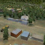
| St Jovite CSZ3 in Quebec Canada |
|
Images related to this file:
File Description:
St Jovite is a grass strip in Quebec near the town of St Jovite and the Mont Tremblant tourist area. This updated version has specifically modeled buildings etc. The unlighted runway is 3,300 feet long, aligned 02/20, and there is now fuel available, so that's a change for the better. However, there is also a landing fee and charges for overnight parking, though the fee is waived if you buy fuel. Based upon my experience of St Jovite there is no AI required for added realism; you will be the only plane visiting and that will be totally realistic. There must be a busy time, but I have never seen it. The aerial picture shows St Jovite from the south, with Lac Ouimet and Mont Tremblant beyond.
| Filename: | St_Jovite_CSZ3_in_Quebec_Canada.zip |
| License: | Freeware, limited distribution |
| Added: | 25th November 2011, 17:29:25 |
| Downloads: | 306 |
| Author: | Roger Wensley |
| Size: | 2.5 MB |
© 2001-2026 AVSIM Online
All Rights Reserved
Privacy Policy |