
Where Flight Simulation Enthusiasts Gather from Around the World!
AVSIM Library - Search Results

| Category: Flight Simulator 2004 - Scenery | |
| FS2004 Scenery - Grand Forks BC Fix |

|
File Description:
Grand Forks BC (CZGF) missing
fence textures for CZGF_v1.zip.
| Filename: | FS2004_Scenery__Grand_Forks_BC_Fix.zip |
| License: | Freeware, limited distribution |
| Added: | 5th November 2005, 14:23:56 |
| Downloads: | 1,385 |
| Author: | Vern Opperman |
| Size: | 67.25 KB |
| Category: Flight Simulator 2004 - Scenery | |
| Grand Staircase Escalante National Monument/East, Escalante (1L7), Utah, Photo-Scenery (FS9 & FSX) |
|
Images related to this file:
File Description:
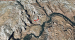
This scenery contains the eastern part of the Grand Staircase Escalante National Monument. It extends from the town of Escalante down south where it connects with the Page/Lake Powell scenery. Contains the upper part of wonderful Escalante Canyon. To explore the scenery depart from Escalante Airport (1L7). Thanks to Joop Mak for providing a custom AFCAD that corrects the airport layout so that it matches with the photo-textures! High resolution versions of this scenery for FS9 and FSX (much sharper, but larger and multiple downloads) are available at www.blueskyscenery.com/CNY_South2West3.html . The screenies are taken from the high-res versions, so expect this version to be slightly more blurry. YourDonation@Work: Dedicated to Jay, Donald and Franz
| Filename: | Grand_Staircase_Escalante_National_MonumentEast_Es.zip |
| License: | Freeware, limited distribution |
| Added: | 4th March 2010, 22:44:30 |
| Downloads: | 1,486 |
| Author: | Gottfried Razek - blueskyscenery.com |
| Size: | 96.2 MB |
| Category: Flight Simulator 2004 - Scenery | |
| KGRR - Grand Rapids Intl for FS9 - Season Fix |
|
Images related to this file:
File Description:
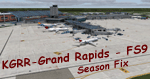
FS9 - KGRR Grand Rapids Airport Change of Seasons Adjustment
This is an update for the FS2004-Team-Forum's conversion of Dillon Rocque's KGRR Grand Rapids airport scenery. It synchronizes the transition to winter and summer with the default FS2004 change of seasons for the area. See Readme for further details.
| Filename: | KGRR__Grand_Rapids_Intl_for_FS9__Season_Fix.zip |
| License: | Freeware |
| Added: | 28th March 2022, 19:34:51 |
| Downloads: | 442 |
| Author: | Gregory Putz, The FS2004-Team |
| Size: | 2.23 MB |
| Category: Flight Simulator 2004 - Scenery | |
| Grand Junction Regional |
|
File Description:
FS2004 - Scenery Grand Junction Regional Airport (Walker Field) (IATA: GJT, ICAO: KGJT, FAA LID: GJT) is a public airport located three miles (5 km) northeast of the central business district of Grand Junction, a city in Mesa County, Colorado, United States. The airport covers 2,357 acres (9.5 km²) and has two runways. It is the largest airport in western Colorado. This Scenery is compatible with both FS9 default and Ultimate Terrain. Created using Instant Scenery by John B. Loney, Jr.
| Filename: | Grand_Junction_Regional.zip |
| License: | Freeware, limited distribution |
| Added: | 11th September 2008, 00:10:25 |
| Downloads: | 1,681 |
| Author: | John B. Loney, Jr. |
| Size: | 1.14 MB |
| Category: Flight Simulator 2004 - Scenery | |
| Grand Forks, British Columbia |
|
File Description:
Grand Forks BC (CZGF) is located in south
central British Columbia known as the Boundary
Region. It is a popular tourist area
for those liking the outdoors, with such
recreational activities as fishing, hiking,
biking and of course, golf. Grand Forks is a
history buffs paradise with many historic
buildings and old mines to explore.
| Filename: | Grand_Forks_British_Columbia.zip |
| License: | Freeware, limited distribution |
| Added: | 3rd November 2005, 23:50:44 |
| Downloads: | 2,163 |
| Author: | Vern Opperman |
| Size: | 2.14 MB |
| Category: Flight Simulator 2004 - Scenery | |
| Bryce Canyon National Park (KBCE), Utah, Photo-Scenery |
|
Images related to this file:
File Description:
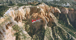
Bryce Canyon National Park (KBCE), Utah, Photo-Scenery (FS9 & FSX)
Despite its name, Bryce Canyon is not actually a canyon that was formed by a river, but rather a giant natural cliff shaped through erosion by wind, water, and ice. Bryce is distinctive due to its geological formations, delicate and colorful pinnacles called hoodoos that are up to 200ft high. The bizarre forms and red, orange and white colors of the rocks provide spectacular views. Unfortunately the hoodoos are too small for the elevation mesh in flight simulator. But you can enjoy the colors and shape of the cliffs. The cliffs in main region of the park, just south of the airport are partly covered
by snow. But on the southern and western part of the plateau you can enjoy them free of snow. Bryce Canyon is named after the Mormon pioneer Ebenezer Bryce who settled in this area in the 1850s. It was designated as a national park in 1928.
Bryce Canyon Airport (KBCE) just handles small aircraft on a daily basis. But is was actually built to handle larger aircraft in case of emergency. And so on Oct.6th 2000 an American Airlines MD-82 from Denver to Los Angeles made a successful emergency landing after reporting smoke in the cockpit and a loss of cabin pressure.
High resolution versions of this scenery for FS9 and FSX (much sharper, but larger and multiple downloads)are available at www.blueskyscenery.com/CNY_South2West4.html . The screenies are taken from the high-res versions, so expect this version to be slightly more blurry. Thanks to Joop Mak for providing a custom AFCADs that correct airport layouts so that they align with the photo-textures! They are available here: www.blueskyscenery.com/AFCADs.html . YourDonation@Work: Dedicated to Michael, Pat and Keith.
| Filename: | Bryce_Canyon_National_Park_KBCE_Utah_PhotoScenery.zip |
| License: | Freeware, limited distribution |
| Added: | 7th March 2010, 11:17:56 |
| Downloads: | 2,206 |
| Author: | Gottfried Razek, blueskyscenery.com |
| Size: | 96.35 MB |
| Category: Flight Simulator 2004 - Scenery | |
| Weiser Muni S87 Idaho |
|
File Description:
Weiser Municipal is located on the Snake River bordering Idaho and Oregon. Follow the river about 60 miles north and you'll be in the spectacular Hell's Canyon area. This scenery was designed for use with Ultimate Terrain USA but is also compatible with the default FS9 scenery.
| Filename: | Weiser_Muni_S87_Idaho.zip |
| License: | Freeware |
| Added: | 3rd January 2009, 23:55:13 |
| Downloads: | 461 |
| Author: | Sidney Schwartz |
| Size: | 464.76 KB |
| Category: Flight Simulator 2004 - Scenery | |
| Lake Powell East / Natural Bridges National Monument, Utah, Photo-Scenery |
|
Images related to this file:
File Description:
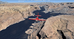
Lake Powell East / Natural Bridges National Monument, Utah, Photo-Scenery (FS9 & FSX)
This scenery covers the eastern part of Lake Powell from just south of Hite (UT03) and goes down south along White Canyon, Natural Bridges National Monument and the Grand Gulch Primitive Area all the way to the San Juan River. It extends my Canyonlands sceneries to the south and brings you another 3.500 sq km of wonderful southern Utah in 4.7m/pix quality. To explore the scenery depart from Cal Black Memorial Apt. (U96) and head east. High resolution versions of this scenery for FS9 and FSX (much sharper, but larger and multiple downloads) are available at www.blueskyscenery.com/CNY_South2West.html. The screenies are taken from the high-res versions, so expect this version to be slightly more blurry. YourDonation@Work: Dedicated to Guy, Ruben and EDB.
| Filename: | Lake_Powell_East__Natural_Bridges_National_Monumen.zip |
| License: | Freeware, limited distribution |
| Added: | 4th January 2010, 19:19:43 |
| Downloads: | 1,871 |
| Author: | Gottfried Razek, blueskyscenery.com |
| Size: | 95.26 MB |
| Category: Flight Simulator 2004 - Scenery | |
| Grand Teton National Park |
|
File Description:
Grand Teton National Park in Wyoming with additional/corrected roads, rivers and lakes. Addon 38.2m mesh such as the excellent FSGenesis Rocky Mountains freeware is necessary to properly view these modifications
| Filename: | Grand_Teton_National_Park.zip |
| License: | Freeware |
| Added: | 4th July 2004, 17:24:44 |
| Downloads: | 2,466 |
| Author: | Victor West |
| Size: | 132.68 KB |
| Category: Flight Simulator 2004 - Scenery | |
| Grand Forks International Airport |
|
File Description:
Grand Forks International Airport (KGFK) serves northeastern North Dakota and northwestern Minnesota and sees plenty of air traffic, thanks to the University of North Dakota's flight school. Scenery includes airline terminal, jetways, FBOs, and hangars from scenery library objects. See readme for required object library files. No custom models were created for this scenery. Not tested with FSX or FS2002.
| Filename: | Grand_Forks_International_Airport.zip |
| License: | Freeware, limited distribution |
| Added: | 30th June 2008, 08:47:53 |
| Downloads: | 1,500 |
| Author: | Eric O'Link |
| Size: | 257.36 KB |
© 2001-2026 AVSIM Online
All Rights Reserved
Privacy Policy |