
Where Flight Simulation Enthusiasts Gather from Around the World!
AVSIM Library - Search Results

| Category: Flight Simulator 2004 - Scenery | |
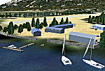
| Cavanaugh Bay 66S Idaho Airport |

|
File Description:
Priest Lake in Idaho is described by their Chamber of Commerce as "...a magnificent 23,000 acre azure lake nestled beneath the majestic Selkirk Mountains — without question, one of the most beautiful wilderness areas you’ll ever see." Cavanaugh Bay is a grass strip right on the lake, with lodges (there's one right next to the end of the runway), campgrounds and boat/plane docks nearby. I think I was able to make a fair approximation of the real thing, based on Google Earth. If you're flying something that floats, choosing RWY S or RWY E from the FS9 airport menu will park you conveniently at a floatplane dock. This scenery was designed for use with Ultimate Terrain USA and has not been tested with the default FS9 scenery.
| Filename: | cavanaugh_bay_66s.zip |
| License: | Freeware |
| Added: | 14th July 2008, 13:38:40 |
| Downloads: | 606 |
| Author: | Sidney Schwartz |
| Size: | 654 KB |
| Category: Flight Simulator 2004 - Scenery | |
| Panama City - Bay Cty 2 |
|
File Description:
FS2004 Scenery-Panama City-Bay Co Intl Airport (KPFN) serves Panama City and Bay County and is owned by Panama City-Bay Co Arpt Dist. The airport has more than one runway. The longest is a paved runway extending 6304 feet. The facility is at an elevation of 21 feet at a distance of about 3 miles from Panama City. Version 2 includes dynamic scenery, Totally redone static scenery taken from Google Earth Satellite Images. All Runways in use. Created with FSDS2.10, Rwy12, EZ Scenery, with a new AFCAD2 file and Traffic Tools. FSDS2 scenery textures included. (Previous version had 1186 downloads)
| Filename: | kpfn_v2.zip |
| License: | Freeware |
| Added: | 27th February 2006, 00:48:28 |
| Downloads: | 3,308 |
| Author: | John B. Loney, Jr. |
| Size: | 1000 KB |
| Category: Flight Simulator 2004 - Scenery | |
| Panama City-Bay Cty Fix2 |
|
File Description:
FS2004 Scenery-This file supercedes the first kpfn fix. Panama City-Bay County Fix2 corrects the building crash error when viewing your aircraft in spot mode looking from the terminal to the nose of the aircraft. For use with kpfn_v2.zip. By John B. Loney, Jr.
| Filename: | kpfn_fx2.zip |
| License: | Freeware |
| Added: | 4th August 2006, 03:45:54 |
| Downloads: | 1,477 |
| Author: | John B. Loney, Jr. |
| Size: | 75 KB |
| Category: Flight Simulator 2004 - Scenery | |
| Shark bay (YSHK) - Western Australia |
|
File Description:
Shark Bay (YSHK) is situated on the west coast of Western Australia just S.W. of Carnarvon. The strip is 3.5nm N.E. of Denham. It can be a very dusty place during high winds. Shark Bay has a very country, outback feel about it.
This scenery was created with Rwy12 Object Placer. The Rwy12 Static Object Library is required for the scenery appear correctly and is avail on Avsim.
| Filename: | shark_bay_(yshk).zip |
| License: | Freeware |
| Added: | 8th October 2005, 15:06:20 |
| Downloads: | 1,052 |
| Author: | Derek Froud |
| Size: | 1.62 MB |
| Category: Flight Simulator 2004 - Scenery | |
| Estrella Bay, Solomon Islands (AMAC) |
|
File Description:
The 'less than stable' pilots over at Margarita Air have released another new scenery, this time at their own private airstrip on the Solomon Islands. Estrella Bay contains a small airstrip with maintenance and fuel facilities along with "TJ's Bar and Grille", the home of cold beer and hot women. Visit http://www.margaritaair.com for more information on this loose band of ragtag pilots.
| Filename: | Estrella_Bay_Solomon_Islands_AMAC.zip |
| License: | Freeware |
| Added: | 16th October 2005, 03:42:52 |
| Downloads: | 974 |
| Author: | Todd Lucas |
| Size: | 2.4 MB |
| Category: Flight Simulator 2004 - Scenery | |
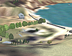
| NZMJ Martins Bay, New Zealand |
|
Images related to this file:
File Description:
Fiordland, New Zealand. 19nm from Milford Sound. You must have Christian Stock's NZ mesh in the form of "Mountains of New Zealand"
and topo in the form of "Lakes and Rivers of New Zealand".
| Filename: | martinsbay_nzmj.zip |
| License: | Freeware |
| Added: | 13th July 2010, 09:19:02 |
| Downloads: | 349 |
| Author: | Godfrey Tier |
| Size: | 865 KB |
| Category: Flight Simulator 2004 - Scenery | |
| Northern Canada Mining CYOA & CHB3 in Canada |
|
Images related to this file:
File Description:
These are two airfields in northern Canada, serving two mining operations. The furthest north is Hope Bay CHB3 in Nunavut. It is in a sheltered inlet less than 3 miles from the northern mainland coast and around 65 miles southwest of Cambridge Bay. The owner is Hope Bay Mining Ltd, and their operation mines gold out of a tunnel rather than open cast. The airfield is incorporated into the road that leads north to the sea; traffic is halted by traffic lights when a flight is expected. The runway is 3,000 feet of gravel aligned 01-19 and with PAPI at both ends.
The second airfield serves the Ekati diamond mine and is some 265 miles southwest of Hope Bay, in the Northwest Territories. Ekati was the first Canadian diamond mine and is 195 miles northeast of Yellowknife and less than 20 miles north of a later mine, Diavik (by Sid and Pete). CYOA reflects the relative value of the two mining operations and is far better equipped than Hope Bay. It can be described as an airport while Hope Bay remains an airfield. The runway is 6,400 feet of gravel aligned 36-18 with PAPI and strobe approach lights at both ends. The scale of the mining operation can only be described as huge.
| Filename: | northern_canada_mining.zip |
| License: | Freeware, limited distribution |
| Added: | 11th August 2018, 22:59:06 |
| Downloads: | 202 |
| Author: | Roger Wensley |
| Size: | 8.57 MB |
| Category: Flight Simulator 2004 - Scenery | |
| Emergency Services Mission 2010-004 |
|
Images related to this file:
File Description:
This is a series of missions called Emergency Services. All mission are flown using the Bell 206B JetRanger Helicopter. You may be flying for Fire Rescue, Medical Rescue or for the Police. In this mission you will be flying for Fire Rescue out of Half Moon Bay Airport in Half Moon Bay, CA. Your incident number is 2010-004
| Filename: | fs9_emergency_services_mission_2010-004.zip |
| License: | Freeware |
| Added: | 13th May 2010, 03:13:52 |
| Downloads: | 251 |
| Author: | David J Crandall |
| Size: | 3.78 MB |
| Category: Flight Simulator 2004 - Scenery | |
| Hauraki Gulf, v6 |
|
Images related to this file:
File Description:
This replaces all my previous Pakatoa Island and Hauraki Gulf sceneries. You must have Christian Stock's NZ mesh in the form of "Mountains of New Zealand" and topo in the form of "Lakes and Rivers of New Zealand" (payware).
New additions...PAKIHI ISLAND: Small jetty and nearby buildings. TAKANGAROA ISLAND: House on Island. House & Jetty island north of Takangaroa Island. MOTUREKAREKA ISLAND: Wreck of the Rewa. PONUI ISLAND: Chamberlain's Bay Airstrip. Chamberlain's Donkey Farm. Third Bay Airstrip. Motunau Bay Jetty. KARAMURAMU ISLAND: Jetty and quarry. ROTOROA ISLAND: Rotoroa Jetty. MOTUIHE ISLAND: Motuihe Wharf.
| Filename: | hauraki_gulf_vs6.zip |
| License: | Freeware |
| Added: | 17th April 2010, 16:10:12 |
| Downloads: | 215 |
| Author: | Godfrey Tier |
| Size: | 6.61 MB |
| Category: Flight Simulator 2004 - Scenery | |
| Lake St. Clair Harrison Township Coastline |
|
File Description:
Scenery corrects the coast line in Harrison Township located between Anchor Bay and L'Anse Creuse Bay near Selfridge ANGB on Lake St. Clair, Michigan. Also adds/corrects the Clinton River and includes land class files to make the area more true to life. Intended for use with my FS9 Selfridge ANGB scenery (Self2004.zip), but also works with the default.
| Filename: | lake_st._clair_coast.zip |
| License: | Freeware |
| Added: | 26th April 2004, 12:49:59 |
| Downloads: | 897 |
| Author: | Matt Magner |
| Size: | 728 KB |
© 2001-2025 AVSIM Online
All Rights Reserved