
Where Flight Simulation Enthusiasts Gather from Around the World!
AVSIM Library - Search Results

| Category: Flight Simulator 2004 - Scenery | |
| Caballococha, Peru |

|
File Description:
Caballococha, Peru - Actually I have found only one photo of the town along the Amazon River and it was only of the Plaza. This is a total impressionistic file. Creates the town, riverside features (Piers, Ferry landing) and a few features to the default airport.
New AFCAD created offering parking and a taxiway, plus two water start locations. Again totally fictious. BUT enjoy.
One thing about Caballococha is that it is along a highly navagatable portion of the Amazon and with the fantastic array of Watercraft available offers, I believe, unlimited simming possibilities.
I included the .XML file for rwy12, if you are into enhancing your own scenery...please do feel free to modify or add as desired. This scenery DOES require both LAGO FSE (Payware) and RWY12 available here at avsim) to work.
questions or comments PLEASE do e-mail me ... I will respond as rapidly as possible.
[email protected]
| Filename: | Caballococha_Peru.zip |
| License: | Freeware |
| Added: | 9th April 2006, 04:19:26 |
| Downloads: | 714 |
| Author: | Dale Caruso |
| Size: | 225.37 KB |
| Category: Flight Simulator 2004 - Scenery | |
| EHAM - Moving Traffic v0.5 |
|
File Description:
This project contains moving traffic around Schiphol Airport (EHAM). There are 4 types of cars and more than 10 colour schemes.
With this project there is just 1 problem:
Traffic will only appear in the first half of the hour. This time is the time of FS, not your system time. After 30 minutes of traffic all cars will disappear. The next 30 minutes it's rather quiet. This means a traffic density of zero. After this 30 minute period, it's rush (half)hour again. This repeats itself.
We don't know the problem yet, but any help is welcome. Some minor problems will be fixed later. This version (v0.5) is the release version because we don't want you to wait any longer.
We hope you'll enjoy this addon in spite of this problem. For other projects or updates: ProjectX
| Filename: | EHAM__Moving_Traffic_v05.zip |
| License: | Freeware |
| Added: | 22nd April 2005, 15:51:58 |
| Downloads: | 5,957 |
| Author: | Paul Koopman, André Koopman, ProjectX |
| Size: | 462.81 KB |
| Category: Flight Simulator 2004 - Scenery | |
| Oliver Pabst's LEPA Textures - 2005 remix |
|
File Description:
A year or so ago I created a texture fix for Oliver Pabst's award-winning scenery for LEPA - the airport at Son Jan Juan - Palma. After visiting there in FS9 I decided to bring a little more detail to the ground textures in order to make them more attractive. The existing apron textures are very grey - and these aren't!!
I also opened the new taxiway to the threshold for runway 24L (and opened both runways in the AFCAD, added jetways at the western terminal (module 1) and added a low-res surface bitmap for the roads etc leading to the terminal. If you're still using Oliver's scenery, you'll probably like this. If you aren't sure - I have some up-front pictures to help you decide.
Many thanks to Oliver for endorsing my previous tweak, I hope this one goes well too. Thanks for the scenery, Oliver!
| Filename: | Oliver_Pabsts_LEPA_Textures__2005_remix.zip |
| License: | Freeware, limited distribution |
| Added: | 10th October 2005, 17:11:19 |
| Downloads: | 13,607 |
| Author: | Oliver Pabst (copyright holder), Matthew Ministry |
| Size: | 2.33 MB |
| Category: Flight Simulator 2004 - Scenery | |
| Kangiqsujuaq CYKF in northern Quebec, Canada |
|
Images related to this file:
File Description:
Kangiqsujuaq is on the north coast of Quebec, 85 miles west of Quaqtaq and 125 miles east of Salluit, while across the Hudson Strait and 100 miles away on Baffin Island is Kimmirut. The town grew around two trading posts, the first opened by Revillon Freres in 1910, and the second by the Hudson Bay Company in 1914. A school was opened in 1960, and a clinic in 1961. The town was known as Wakeham Bay until 1961, and now has a population of around 700. The airport is to the south of the town and up on the hill at 511 feet ASL (this has been remeasured since 2004 and is now known to be 501). The gravel runway is just over 3,500 feet long and aligned 15/33; there is no PAPI, but there is fuel available, both 100LL and JetA. There are flights by Air Inuit.
| Filename: | Kangiqsujuaq_CYKF_in_northern_Quebec_Canada.zip |
| License: | Freeware, limited distribution |
| Added: | 27th January 2013, 00:55:00 |
| Downloads: | 231 |
| Author: | Roger Wensley |
| Size: | 2.31 MB |
| Category: Flight Simulator 2004 - Scenery | |
| Torrey, Box-Death Hollow Wilderness, Aquarius Plateau, Utah, Photo-Scenery (FS9 & FSX) |
|
Images related to this file:
File Description:
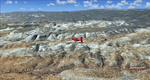
The southern part of this region covers the Box-Death Hollow Wilderness, with its vertical gray-orange walls of Navajo sandstone. Then comes the Aquarius Plateau which is the highest timbered plateau in North America with Boulder Mountain. In the north you'll find the little town of Torrey, which is just eight miles west of Capitol Reef National Park. Extends my Grand Staircase Escalante scenery to the north.
High resolution versions of this scenery for FS9 and FSX (much sharper, but larger and multiple downloads) are available at www.blueskyscenery.com/CNY_SouthWest3.html . The screenies are taken from the high-res versions, so expect this version to be slightly more blurry.
Thanks to Joop Mak for providing a custom AFCADs that correct airport layouts so that they align with the photo-textures! They are available here: www.blueskyscenery.com/AFCADs.html . YourDonation@Work: Dedicated to Ralf-Peter, Jon and Laurent.
| Filename: | Torrey_BoxDeath_Hollow_Wilderness_Aquarius_Plateau.zip |
| License: | Freeware, limited distribution |
| Added: | 3rd April 2010, 00:52:09 |
| Downloads: | 1,202 |
| Author: | Gottfried Razek - blueskyscenery.com |
| Size: | 93.79 MB |
| Category: Flight Simulator 2004 - Scenery | |
| Whaletown CAW9 in British Columbia, Canada |
|
Images related to this file:
File Description:
Whaletown is a float base serving a village on Cortes Island, another one of the many islands squeezed between Vancouver Island and the mainland at this northern end. At this island passengers are delivered by amphibious Grumman Goose from Port Hardy, the main airport of the northern half of Vancouver Island with daily scheduled flights onward to and from Vancouver International. The AI was included with the post of Port Hardy. Regretably, the amphibious Goose behaves as if it is on land and moves on the water with it's wheels extended; there is no way around this. This scenery is a modification of a post made some years ago that did not support AI. In my FS9, close to Whaletown, there was an FS9 or Ultimate Terrain fault consisting of a long straight beach sticking out into the sea for a few thousand feet. This scenery now deletes that.
| Filename: | Whaletown_CAW9_in_British_Columbia_Canada.zip |
| License: | Freeware, limited distribution |
| Added: | 28th November 2018, 22:43:21 |
| Downloads: | 105 |
| Author: | Roger Wensley |
| Size: | 1.67 MB |
| Category: Flight Simulator 2004 - Scenery | |
| PADK - Adak - Aleutians, Alaska - USA |
|
Images related to this file:
File Description:
Adak is near the western end of the Aleutian chain of islands in Alaska. The closed naval air base buildings are mostly still there and once housed over 6,000; the population is now much reduced to around 320, involved in fishing and a fish processing plant, organising caribou hunts for the tourism industry, running the airport, etc. The runways are long and wide (both are over 7,000 feet) and aligned 23-05 (with an ils) and 18-36. There are flights from Anchorage on Thursdays and Sundays by Alaska Airlines (a 737) and occasional charters from Dutch Harbor by Grant Aviation, 445 miles east of Adak. The Ai included here contains these flights. There are revisions included for Dutch Harbor PADU which provide parking for more Grant planes, as Grant are now also running flights to Akun Island, east of Dutch Harbor; more Aleutian posts to follow.
| Filename: | PADK__Adak__Aleutians_Alaska__USA.zip |
| License: | Freeware, limited distribution |
| Added: | 13th January 2015, 23:32:44 |
| Downloads: | 557 |
| Author: | Roger Wensley |
| Size: | 7.59 MB |
| Category: Flight Simulator 2004 - Scenery | |
| Central Europe 1961 |
|
Images related to this file:
File Description:
This scenery package contains twelve airports in Germany, nine in the Netherlands, one in Luxembourg, three in Switzerland , and three in Austria - providing taxiways and details as they were at the beginning of the 1960's.
We also created the harbors of Rotterdam, Hamburg and Den Helder, all the lighthouses along the Dutch coast and some along the German coast, and created the island of Helgoland from scratch. Although most of the airports of the package are for civil use, we also produced some Dutch military bases with AI and static aircraft. At many of the airports you will find moving crash tenders and at Amsterdam moving airport buses. Although we did not always have enough photos and information we tried to come as close as possible. Our goal was to reflect something of the atmosphere and feel of that period, prior to the all-jet era of today.
| Filename: | Central_Europe_1961.zip |
| License: | Freeware, limited distribution |
| Added: | 17th May 2013, 20:07:54 |
| Downloads: | 6,642 |
| Author: | Wolfgang Gersch, Harry Biard, Michael Schneider,Jaap de Baare, Nikko Yaginuma, Tom Gibson, Bernard Leuenberger and Mike Stevens |
| Size: | 55.23 MB |
| Category: Flight Simulator 2004 - Scenery | |
| St Michael Island in Alaska-St Michael 5S8 and Stebbins WBB |
|
Images related to this file:
File Description:
St Michael Island is 50 miles southwest of Unalakleet, an island that in fact appears to be a cape and a firmly attached piece of the mainland. On the island there are two villages, St Michael on the northeast corner and Stebbins on the northwest. St Michael has a new airfield that is west of the village by around a mile or so, with a gravel runway 4,000 feet long. The old and now closed airport was known as SMK, and is now readily identifiable by the new red-roofed school building that occupies the centre of the runway. The new airfield now has an icao code of PAMK, but FS9 does not readily accept icao code changes so we are stuck with the original code it was given, 5S8. The SMK icao of the old airport will still show on your gps as if I deleted it the runway would also have to be deleted, and a substitute and unsatisfactory gravel apron made to impersonate a runway. Stebbins is 5 miles west of St Michael and next to the shore, a smaller village than St Michael with around 250 inhabitants. The airfield is at the southern end of the village and has a gravel runway that is 3,000 feet long. The icao code is WBB. There is no AI included here as it was already included in the post of Shaktoolik. There is a correction here for Shaktoolik, which I now find should have had a blue garage, not a red one; I wrongly named a photo. A note here about my scenery making. This is post number 501 and there will not be many more to follow this as I am almost at the end of the photos I took or found for scenery purposes. There is a limit to what can be located online and I have already been making use of the little there is; eg Unalakleet. So, if you are near an airfield (preferably Canadian or Alaskan) and have a camera..... Let me know.
| Filename: | St_Michael_Island_in_AlaskaSt_Michael_5S8_and_Steb.zip |
| License: | Freeware, limited distribution |
| Added: | 1st August 2019, 16:45:58 |
| Downloads: | 93 |
| Author: | Roger Wensley |
| Size: | 3.88 MB |
| Category: Flight Simulator 2004 - Scenery | |
| Iles de la Madeleine CYGR in Quebec Canada |
|
Images related to this file:
File Description:
The Iles de la Madeleine are a group of spit islands linked by bridges in the Gulf of St Lawrence. They are east of New Brunswick, north of Cape Breton Island, west of the Island of Newfoundland, and south of the mainland coast of Quebec. On a southwest to northeast axis they are 40 miles in length and the airport CYGR is pretty much at the midpoint of the southern line of islands. Take a look at the overhead from FS9 to see what I mean. CYGR has two runways, one is aligned 08-26 and is just under 4,400 feet long and 150 feet wide with lighting and PAPI at both ends. The second is aligned 16-34 and is 3,600 feet long and 150 feet wide, without lights or PAPI. Both are asphalt. The apron is not huge, and a newish (in 2010) hangar was built with separate access to the 16-34 runway. There are daily flights by Air Canada and Pascan Aviation included in the AI. The AI also includes some boats and a ferry, and I first used these with my Dutch Harbor scenery, so if you have that already.... This scenery also includes Cindy Hook, a small boat harbour just 2 miles southwest of the airport, and the larger harbour at Cap aux Meules a further 3 miles away that accommodates the daily ferry trips, along with fishing boats etc. Also included here is a further addition to the Homer PAHO scenery in the shape of a boat that is included in the Homer Spit harbour. Just add the contents of the scenery folder to the Homer scenery folder of your Homer installation, and the texture folder contents to the Homer texture folder. This is hopefully the last PAHO addition, and again apologies. If you find an error email me please, and note that my email address has been changed to rogwens at Gmail dot com.
| Filename: | Iles_de_la_Madeleine_CYGR_in_Quebec_Canada.zip |
| License: | Freeware, limited distribution |
| Added: | 28th July 2021, 17:02:18 |
| Downloads: | 188 |
| Author: | Roger Wensley |
| Size: | 26.7 MB |
© 2001-2026 AVSIM Online
All Rights Reserved
Privacy Policy |