
Where Flight Simulation Enthusiasts Gather from Around the World!
AVSIM Library - Search Results

| Category: Flight Simulator 2004 - Scenery | |
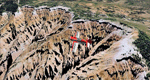
| Anahim Lake CAJ4 in British Columbia, Canada |

|
Images related to this file:
File Description:
Anahim Lake is around 55 miles east of Bella Coola by air, and clear of the deep and rugged valley that connects the two with a road that is over 75 miles long. The two are also linked by a daily Pacific Coastal flight. A further 150 miles east is Williams Lake (200 miles by road). The town of Anahim Lake is small, but renowned for numerous surrounding fishing lodges on the lakes and the enjoyment of "nature" in what is known as the Chilcotin Wilderness. The Anahim Lake airport is an odd one. It appears to have fallen into disuse over a period of years, but is now in the process of being upgraded, with some new hangars (though oddly situated, and with only dirt track taxiway access) and a recently completed terminal building. There is also a plan to upgrade the runway (lights etc, there are currently no runway or taxiway lights) and in general to greatly improve the facilities on offer. The only current airline to fly there is Pacific Coastal. The runway is just under 4,000 feet of asphalt aligned 13-31 and 75 feet wide. There used to be another runway which is still visible but is now unusable, gravel that has not been maintained for several years. The notes for Anahim Lake airfield in the Nav Canada manual warn of "Extensive float plane activity at Nimpo Lake to the south" and of "possible large animals within the airport perimeter". Nimpo Lake activity will follow in further posts.
| Filename: | Anahim_Lake_CAJ4_in_British_Columbia_Canada.zip |
| License: | Freeware, limited distribution |
| Added: | 29th November 2018, 19:21:59 |
| Downloads: | 152 |
| Author: | Roger Wensley |
| Size: | 5.72 MB |
| Category: Flight Simulator 2004 - Scenery | |
| CNZ3 - Chatham-Kent - Ontario, Canada V1 |
|
Images related to this file:
File Description:
This is partly part of the Small Ontario Fields series. The airport ICAO was changed from CNZ3 to CYCK in November 2012; I have left it as it was. The runway too remains as it was a few years ago. Chatham is located 50 miles east of Detroit and 150 miles southwest of Toronto, between Lake St. Clair and Lake Erie, and the airfield is southeast of the town. There is a single asphalt runway 5,000 feet long and 75 feet wide, aligned 05/23 in FS9 but in fact in real life now 06/24 due to the wandering magnetic north. The apron is on the northern side of the runway at the eastern end, with added taxiways to cater for newer hangars wearing identical colour schemes. There is fuel, runway lighting, some taxiway lights, visitor parking on the grass, and plane maintenance in the large hangar beside the small terminal building on the north side of the apron. There is a train station in the middle of the town, and no scheduled flights to the airport that is 8 miles away; these two facts may be connected. Ditches along the road and around much of the airfield provide separation, which is why the fences are not continuous. If you are on the runway and find your path to the apron blocked by another plane that is stationary at the hold short, continue past the first turnoff to the threshold markers and turn off the runway and wait. The AI plane will then taxi out and you will have a clear path.
| Filename: | CNZ3__ChathamKent__Ontario_Canada_V1.zip |
| License: | Freeware, limited distribution |
| Added: | 27th August 2015, 21:02:59 |
| Downloads: | 341 |
| Author: | Roger Wensley |
| Size: | 9.89 MB |
| Category: Flight Simulator 2004 - Scenery | |
| Zion National Park North, Cedar Breaks National Monument, Cedar City (KCDC), Utah, Photo-Scenery (FS9 & FSX) |
|
Images related to this file:
File Description:
Cedar Breaks National Monument is a large amphitheater cliff in bright colors of red, orange and purple.
It lies east of Cedar City in the northern region of the scenery. The cliff was formed by erosion thru wind,
water and ice. Today erosion continues with a pace of about 2 inches every 5 years. Although it is called
Cedar Breaks, there are no cedars growing there but juniper trees. For a scenic flight to Cedar Breaks
National Monument best depart from Cedar City Regional Airport (KCDC) and head east. The scenery extends
south to Zion National Park and covers a large part of Zion Canyon and the Kolob Canyons area.
Zion National Park is another place where erosion of the Colorado Plateau formed the most beautiful colorful
stone formations of unique and wonderful shapes. There are nine different layers of stone visible in the park.
Most of them consist of sandstone. But there is also limestone, gypsum, siltstone, shale, clay and mudstone.
The Virgin River cut a spectacular and famous canyon thru Zion Park that is as narrow as 20ft and up to 2000ft tall.
High resolution versions of this scenery for FS9 and FSX (much sharper, but larger and multiple downloads)
are available at www.blueskyscenery.com/CNY_South2West5.html . The screenies are taken from the high-res versions,
so expect this version to be slightly more blurry.
Thanks to Joop Mak for providing a custom AFCADs that correct airport layouts so that they align with the photo-textures!
They are available here: www.blueskyscenery.com/AFCADs.html . YourDonation@Work: Dedicated to Richard, P.J. and Felix.
| Filename: | Zion_National_Park_North_Cedar_Breaks_National_Mon.zip |
| License: | Freeware, limited distribution |
| Added: | 14th March 2010, 00:30:28 |
| Downloads: | 1,564 |
| Author: | Gottfried Razek - blueskyscenery.com |
| Size: | 97.13 MB |
| Category: Flight Simulator 2004 - Scenery | |
| Wilgrove Airpark (8A6) |
|
Images related to this file:
File Description:
Wilgrove Airpark (8A6) is a small GA airport located just east of Charlotte, NC. It is often forgotten by pilots in Flightsimulator, yet it is a very busy place in the real-world, due to it's huge popularity with student and weekend GA pilots. There has never been a really good, accurate representation of this little gem created for the flightsim, so I decided to try my hand at it. This is my very first scenery project, and I hope you enjoy it. It was designed with ADE9X, and it requires RWY12 and EZ-Scenery objects extensively,(not included) so you will need to download these freeware scenery libraries prior to installation of this package for the Wilgrove Airpark scenery to display properly. - Glenn Mullis
| Filename: | Wilgrove_Airpark_8A6.zip |
| License: | Freeware, limited distribution |
| Added: | 22nd September 2010, 16:59:32 |
| Downloads: | 278 |
| Author: | Glenn Mullis |
| Size: | 4.4 MB |
| Category: Flight Simulator 2004 - Scenery | |
| Project The future of german antarctic research: Neumayer Station III |
|
File Description:
Project The future of german antarctic research: Neumayer Station III for FS2004: With the construction of Neumayer Station III, the conditions necessary to meet scientific and logistical demands associated with long-term research operations in the Antarctic will be met. The new station, built to modern standards and with state-of-the-art technology, will enable the continuation of long-term measurements by the scientific observatories for meteorology, geophysics and atmospheric chemistry, as well as the establishment of new research projects. Airport ICAO: NMS3 build by Dirk Stuck 2008.
More Info under:http://www.awi.de/en/infrastructure/stations/neumayer_station_iii/
Check AVSIM or my Webpage Http://www.flight-team-bremerhaven.de for more Addons.© by Fireeagle 2008 By Dirk Stuck EMail:[email protected]
| Filename: | Project_The_future_of_german_antarctic_research_Ne.zip |
| License: | Freeware |
| Added: | 23rd September 2008, 22:21:20 |
| Downloads: | 2,160 |
| Author: | Dirk Stuck |
| Size: | 3.66 MB |
| Category: Flight Simulator 2004 - Scenery | |
| SVUM version fs10 |
|
File Description:
This is the latest scenery file for Angel Falls (SVUM).
Margarita Air Club is a virtual flying club based in the Caribbean that beleives that flying on the simulator should be FUN, not a chore. If you like what you see, please visit our website at http://www.margaritaair.com.
This file is intended to COMPLETELY replace the older versions of SVUM. This file, written in xml language and compiled using the new FS2004 SDK's should be compatible with all near-future versions of MSFS (or at least thats what they promise - LOL).
Once installed, you will see the airport buildings and static aircraft parked on the ramp.
THIS FILE IS COMPATIBLE WITH THE LATEST ANGEL FALLS SCENERY canaima_angelfalls.zip available here at AVSIM
| Filename: | SVUM_version_fs10.zip |
| License: | Freeware |
| Added: | 5th June 2006, 04:47:40 |
| Downloads: | 1,187 |
| Author: | Todd Lucas |
| Size: | 1.11 MB |
| Category: Flight Simulator 2004 - Scenery | |
| Retro Scenery for NAS Chase Field, Texas, U.S.A. |
|
Images related to this file:
File Description:

Originally opened as Beeville Municipal Airport, the land was leased from the Navy in 1943 for the construction of Chase Field, a training base for Naval Air Cadets and was one of three satellite airfields for Corpus Christi NAS. At the end of WWII the station was closed and re-purposed for various educational and local civic uses only to be reopened with the commencement of the Korean War in 1953. This resulted in a significant expansion of the original facilities and by the early 1980s Chase Field had a complement of 2,500, along with over 160 aircraft. Finally BRAC-ed in 1991 the field was finally closed in 1993. Scenery contains custom objects as well as photo-realistic ground cover with provisions for appropriate aircraft.
| Filename: | Retro_Scenery_for_NAS_Chase_Field_Texas_USA.zip |
| License: | Freeware, limited distribution |
| Added: | 27th April 2014, 21:31:40 |
| Downloads: | 668 |
| Author: | John Stinstrom |
| Size: | 2.58 MB |
| Category: Flight Simulator 2004 - Scenery | |
| Pinal Airpark KMZJ |
|
File Description:
FS2004 Scenery - Pinal Airpark (IATA: MZJ, ICAO: KMZJ) is an airport located in Pinal County, seven miles (11 km) northwest of the central business district (CBD) of Marana, a city in Pima County, Arizona, USA. Its main purpose is to act as a "boneyard" for aircraft. Old airplanes are stored there with the hope that the dry desert climate will prevent rust and other forms of corrosion in case the aircraft is pressed into service in the future. Even so, many aircraft which are brought there wind up being scrapped. Nearby Davis-Monthan Air Force Base provides the same service to the U.S. military. Compatible with both FS default and Ultimate Terrain. EZ Scenery Libraries required. Some included. by JOhn B. Loney, Jr.
| Filename: | Pinal_Airpark_KMZJ.zip |
| License: | Freeware, limited distribution |
| Added: | 16th March 2008, 05:46:41 |
| Downloads: | 1,619 |
| Author: | John B. Loney, Jr. |
| Size: | 7.14 MB |
| Category: Flight Simulator 2004 - Scenery | |
| KSBA New JUN08 AFCAD w/ Al Wheeler's objects |
|
File Description:
Contemporary KSBA, Santa barbara Municiple Airport scenery as of June 2008 with Scenery object by Al Wheeler.With wheeler's scenery objects, this scenery is packed individually, ready to use by itself. Installtion guide included. Changes included: 1) New taxiway M, K & P
2) original Alpha 07 end curve became P and A extended to the end of rwy 25
but the length of 25 did not change becuse it is "moved forward"
3) J and G near 25 is widen
4) 3 Helipads
5) Grass sides
6) closed link on the end of A and D
7) added taxi signs, you will never get lost a gain
hope you like it and log in to KSBA in vatsim - By James Luen
| Filename: | KSBA_New_JUN08_AFCAD_w_Al_Wheelers_objects.zip |
| License: | Freeware |
| Added: | 16th June 2008, 19:43:14 |
| Downloads: | 1,862 |
| Author: | James Luen |
| Size: | 5.46 MB |
| Category: Flight Simulator 2004 - Scenery | |
| CYXN - Whale Cove - Hudson Bay, Nunavut, Canada, Version v2 modified 1 July 2014 |
|
Images related to this file:
File Description:
This revised version deletes stock FS9 taxiway lights and replaces them. It also modifies and corrects the PAPI positioning, and removes a visible hold short that should have been invisible on the gravel. This is a complete version and does not require you to have installed the old version. Whale Cove is a small village with 300 or so inhabitants at N62 W92 on the west shore of Hudson Bay, 40 miles south of the large airport at Rankin Inlet. The runway is just under 4,000 feet and aligned 330T-150T, these being true and not magnetic bearings. The AI is included with the post of Chesterfield Inlet V1 and the earlier version is omitted from this post to avoid confusion.
| Filename: | CYXN__Whale_Cove__Hudson_Bay_Nunavut_Canada_Versio.zip |
| License: | Freeware, limited distribution |
| Added: | 23rd August 2014, 11:24:44 |
| Downloads: | 273 |
| Author: | Roger Wensley |
| Size: | 1.73 MB |
© 2001-2026 AVSIM Online
All Rights Reserved
Privacy Policy |