
Where Flight Simulation Enthusiasts Gather from Around the World!
AVSIM Library - Search Results

| Category: Flight Simulator 2004 - Scenery | |
| Fortaleza City 2004 (BRAZIL) v5 |

|
Images related to this file:
File Description:
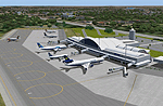
This version -- v5 -- adds new features of Fortaleza FiX BUG (Object invisible collision) observed in some system near GATE6 and 7 and add FINE TUNING in Night Textures in previous versions. Realistic FS2004 scenery Fortaleza City at northeast in Brazil (BR/Brasil) - Ceara. Full Scenery of the City includes a detailed International Airport Pinto Martins (SBFZ) with ANIMATED GATES CONTROLLED BY NAV1, NAV2 and AFCAD,the Air Base of Fortaleza, the detailed airfield SNFF (Feijo Aerodrome) with ANIMATED Hangars DOORS News landclasses, coastlines, lakes, buildings, Castelao Stadium ...ALL NIGHT TEXTURES! Development in great part in GMAX. (11th November 2004). Includes: fortalv5.zip + fortaleza_v5_update.zip
| Filename: | Fortaleza_City_2004_BRAZIL_v5.zip |
| License: | Freeware |
| Added: | 11th December 2009, 12:45:54 |
| Downloads: | 20,728 |
| Author: | Alvaro Volponi |
| Size: | 5.53 MB |
| Category: Flight Simulator 2004 - Scenery | |
| Boise Air Terminal |
|
File Description:
This is my first release of Boise Air Terminal in Boise, Idaho. This scenery was created for FS2004, and will not work with earlier versions. It completely replaces the terminal and concourse areas, most of the GA and freight areas on the north side, and most of the Air Guard areas on the south side. The SW GA areas remain default. It's based on extensive photos of the airport, and most of the added objects are near photo-real. It was created completely with GMax and .xml coding, so the frame rate hit will be minimal if any at all.
| Filename: | Boise_Air_Terminal.zip |
| License: | Freeware, limited distribution |
| Added: | 13th January 2006, 17:25:44 |
| Downloads: | 8,935 |
| Author: | Gary Widup |
| Size: | 1.76 MB |
| Category: Flight Simulator 2004 - Scenery | |
| Scenic Cincinnati 2025 |
|
Images related to this file:
File Description:
This scenery package was created to spruce up the Ohio River valley in and around downtown Cincinnati as well as just across the Ohio River in Northern Kentucky. Over 60 unique buildings have been 3D designed, processed in MCX, and placed into FS9 as accurately as possible. Additionally, several default scenery buildings, such as the old Riverfront Stadium, have been removed and replaced with Paycor Stadium (Bengals) and Great American Ballpark (Reds).
The buildings have all been created to represent what you would normally observe while flying into the Greater Cincinnati – Northern Kentucky International Airport (KCVG). Some buildings contain more detail than others.
| Filename: | Scenic_Cincinnati_2025.zip |
| License: | Freeware, limited distribution |
| Added: | 12th March 2025, 15:28:43 |
| Downloads: | 190 |
| Author: | Michael Lehkamp |
| Size: | 26.24 MB |
| Category: Flight Simulator 2004 - Scenery | |
| CYOC - Old Crow - Yukon Territory, Canada |
|
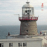
Images related to this file:
File Description:
Old Crow is in the far north of the Yukon Territory, Canada, 115 miles south of the nearest coastline and 30 miles east of the border with Alaska. The town has a population of less than 300 and the population are reliant on the caribou migration for an annual food supply replenishment. The fact that it is the only Yukon town that cannot be reached by car makes the airport important, and there are regular flights by Air North, the Yukon airline. They are included in the AI along with GA aircraft. I had several tries at matching up the Hawker Siddeley 748 with the right set of textures and I have included both here so that you do not have to go through the same torture. Thanks go to Hernan for sorting all that out, and for his textures. The airport is beside the town that is built along a bank of the Porcupine River. I have replicated the current shore line of the river that has cut a new channel at one end of the town, and I flattened the river as it was somewhat mountainous. The runway is gravel and just over 5,000 feet long, aligned 03-21. The terminal building is specific to Old Crow as I had photos, but the hangars are approximations and the village houses are only representational.
| Filename: | CYOC__Old_Crow__Yukon_Territory_Canada.zip |
| License: | Freeware, limited distribution |
| Added: | 5th December 2014, 13:31:46 |
| Downloads: | 370 |
| Author: | Roger Wensley |
| Size: | 7.58 MB |
| Category: Flight Simulator 2004 - Scenery | |
| CYPE - Peace River - Northwest Alberta, Canada |
|
Images related to this file:
File Description:
The Peace River flows east from the Rockies, joining up with the Slave River to empty into Great Slave Lake. The town is on both banks close to a bend, 245 miles northwest of Edmonton. The population is 7,000 and the surrounding area is either farmland or forest and used for winter sports; Peace River hosted the 2004 Alberta Winter Games. The airport is just over 3 miles west of the town. The runway is 5,000 feet of wide asphalt (150 feet) aligned 04/22, lit, and with PAPI. There is a second runway to the south of the main runway, 1,900 feet of grass and aligned 08/26. The apron is to the north of the runway at the eastern end and is large; there is a purpose-built terminal building, plus other hangar buildings along taxiway C that extends westward from the apron. The airport gives the impression that it is under-used; there are no long lines of parked planes waiting for the weekend and few scheduled flights. These are mainly (totally?) by Sunwest Home Aviation, but unfortunately nobody has made the textures for Sunwest and my talents do not run in that direction so I have made believable substitutions. There is also a small but obstinate AI difficulty, described in the notes.
| Filename: | CYPE__Peace_River__Northwest_Alberta_Canada.zip |
| License: | Freeware, limited distribution |
| Added: | 10th November 2013, 23:56:22 |
| Downloads: | 332 |
| Author: | Roger Wensley |
| Size: | 10.83 MB |
| Category: Flight Simulator 2004 - Scenery | |
| Peace River CYPE in northwest Alberta, Canada UPDATED |
|
Images related to this file:
File Description:
This is an updated version of the original post (from 2014) made in November 2018. It provides missing textures, and deals properly with an ai problem that I thought I had already fixed. It also adds extra objects to the apron area and adds a third gate. It is complete in itself and can be installed as-is if you do not have the original post. The Peace River flows east from the Rockies, joining up with the Slave River to empty into Great Slave Lake. The town is on both banks close to a bend where the Peace turns to the north, 245 miles northwest of Edmonton. The population is 7,000 and the surrounding area is either farmland or forest. The airport is just over 3 miles west of the town. The runway is 5,000 feet of wide asphalt (150 feet) aligned 04/22, lit, and with PAPI. There is a second runway to the south of the main runway, 1,900 feet of grass and aligned 08/26. The apron is to the north of the runway at the eastern end and is large; there is a purpose-built terminal building, plus other hangar buildings along taxiway C that extends westward from the apron. The airport is experiencing an increase in scheduled and GA flights in the last few years.
| Filename: | Peace_River_CYPE_in_northwest_Alberta_Canada_UPDAT.zip |
| License: | Freeware, limited distribution |
| Added: | 10th December 2018, 17:33:25 |
| Downloads: | 127 |
| Author: | Roger Wensley |
| Size: | 24.27 MB |
| Category: Flight Simulator 2004 - Scenery | |
| Terrace CYXT Updated |
|
Images related to this file:
File Description:
This revises the previous versions by adding two missing buildings, corrects the apron markings and parking and adds a third gate, creates more GA parking, updates the AI to include, for instance, a Westjet flight, and most importantly of all adds the ILS to runway 33. It is complete in itself and can be installed as-is without first installing previous versions. Terrace is fifteen miles east and inland from Prince Rupert, which is 500 miles north of Vancouver up the BC coast. It is at the point in the mountains where two fjords meet, one coming from Prince Rupert and the other from Kitimat. The population of the town is around 12,500. The airport is called Terrace-Kitimat and is a couple of miles south of the town of Terrace, on the south side of the Skeena River. There are two runways, and the main one is a recently-extended 7,500 feet long and lit 33-15 with approach lighting to both ends and an ILS on 33. The second is 5,373 feet of unlit 03-21. The apron has been enlarged to be able to accommodate a Boeing 737, though there is at the moment no airline using a 737 for flights to Terrace. The pics and the video show the surrounding hilly terrain and the nearby river between the airport and the town.
| Filename: | Terrace_CYXT_Updated.zip |
| License: | Freeware, limited distribution |
| Added: | 13th January 2019, 18:38:12 |
| Downloads: | 176 |
| Author: | Roger Wensley |
| Size: | 15.64 MB |
| Category: Flight Simulator 2004 - Scenery | |
| Z19O - Hamat Airbase - Batroun, Lebanon |
|
Images related to this file:
File Description:
Hamat is a village near the coast of Lebanon, around 25 miles north of Beirut. The airport runway was built during the civil war to the west of Hamat in the late 1970's, between Hamat and another village called Wuajh Al Hajar. The intention was have an alternative to Beirut airport, which could be (and often was) closed by shell fire from any or all of the sides involved in the civil war, or by bombing by those who were not directly part of the civil war but occasionally joined in. It has been used for drag racing, occasional freefall parachuting (this may continue) and is now an army base with mostly helicopter use. The runway is around 5,600 feet of asphalt, 90 feet wide and aligned 02/20. There is no lighting. The apron is set well back from the runway and has hangars at each end; one set is four hangars long, and at the other end of the apron there are three hangars. There are also the remains of some radar to the west of the apron, bombed (in 1982?). The runway has been repositioned and the surrounding landclass modified to reduce one village to it's approximate actual size and to create a second village which was missing entirely. An intrusive road has been deleted, and the airfield grass area also modified.
| Filename: | Z19O__Hamat_Airbase__Batroun_Lebanon.zip |
| License: | Freeware, limited distribution |
| Added: | 23rd May 2015, 10:03:10 |
| Downloads: | 223 |
| Author: | Roger Wensley |
| Size: | 8.53 MB |
| Category: Flight Simulator 2004 - Scenery | |
| Sydney Nova Scotia 1955-1957 |
|
File Description:
In the period after 1945 Sydney was an important alternate airport for commercial aircraft flying the North Atlantic route between Europe and the U.S.A and Canada. Like Moncton and Goose Bay, it was in a sense a satellite of the much better known Gander, which was however sometimes rendered unusable by adverse weather conditions and especially fog. Sydney had two runways equiped with ILS wnen Gander only had one, and approach lights on all runways, unlike Gander. This scenery is primarily intended for use in the California Classic retro environment created by Tom Gibson and the CalClassic Community, and awaits your Stratocruisers, Douglases and Constellations.
| Filename: | Sydney_Nova_Scotia_19551957.zip |
| License: | Freeware |
| Added: | 1st January 2023, 18:23:53 |
| Downloads: | 153 |
| Author: | Ken Lawson |
| Size: | 2.84 MB |
| Category: Flight Simulator 2004 - Scenery | |
| Dublin Bay Scenery |
|
Images related to this file:
File Description:
FS2004 Dublin Bay Scenery. Coastal scenery in the bay around Dublin including landmarks such as Howth harbour, Dun Laoghaire Harbour, the Bailey lighthouse, Kish lighthouse (complete with landable helicopter pad), typical sea traffic in Dublin Bay and some other landmark buildings. This scenery was designed to work in conjunction with the FS2004 Irish Airports Scenery by the IFSD team and available here at AVSIM (ifsd.zip) and to make flying over Dublin Bay a bit more realistic and interesting, especially on approach to Dublin Airport.
This is a manual zip file install, please refer to the included "Readme.pdf" document for instructions. Scenery by Michael Kelly
| Filename: | Dublin_Bay_Scenery.zip |
| License: | Freeware |
| Added: | 18th April 2023, 16:02:28 |
| Downloads: | 179 |
| Author: | Michael Kelly |
| Size: | 4.77 MB |
© 2001-2026 AVSIM Online
All Rights Reserved
Privacy Policy |