
Where Flight Simulation Enthusiasts Gather from Around the World!
AVSIM Library - Search Results

| Category: Flight Simulator 2004 - Scenery | |
| Kanab (KKNB), Utah/Arizona, Photo-Scenery (FS9 & FSX) |

|
Images related to this file:
File Description:
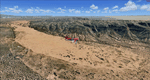
This scenery covers the southwestern part of Grand Staircase-Escalante National Monument. From the air
you can see all the "stairs" from the Pink Cliffs of Bryce Canyon in the north down to the Grey Cliffs,
the White Cliffs and the Vermillion Cliffs just north of Kanab and then the Chocolate Cliffs further south.
Nothwest of Kanab you can fly above beautiful Coral Pink Sand Dunes State Park which features coral-hued
sand dunes located beside red sandstone cliffs. These dunes consist of sand that formed thru erosion of
pink colored Navajo Sandstone surrounding the park and was deposited by wind. To explore the scenery depart
from Kanab Airport (KKNB).
High resolution versions of this scenery for FS9 and FSX (much sharper, but larger and multiple downloads)
are available at www.blueskyscenery.com/CNY_South3West4.html . The screenies are taken from the high-res versions,
so expect this version to be slightly more blurry. Thanks to Joop Mak for providing custom AFCADs that
correct airport layouts so that they align with the photo-textures! They are available at
www.blueskyscenery.com/AFCADs.html . YourDonation@Work: Dedicated to Jesper, Fabrizio and Glen.
| Filename: | Kanab_KKNB_UtahArizona_PhotoScenery_FS9__FSX.zip |
| License: | Freeware, limited distribution |
| Added: | 10th March 2010, 22:24:53 |
| Downloads: | 1,506 |
| Author: | Gottfried Razek - blueskyscenery.com |
| Size: | 95.36 MB |
| Category: Flight Simulator 2004 - Scenery | |
| Iqaluit CYFB 2010 |
|
Images related to this file:
File Description:
Founded in 1942 as an American airbase, Iqaluit is now the capital city of the northern Canadian province of Nunavut. It is the smallest Canadian capital in terms of population and the only capital that is not connected to other settlements by a highway. The airport is of critical importance to the community, especially when ice makes boat travel impossible. At 62 degrees latitude (approx. the same as Yellowknife), Iqualuit offers some of the most severe weather you are likely to encounter at any airport, and has been used for cold weather testing of new airliners.
This version of Iqaluit is a complete rebuild of the default version. Almost all the buildings have been custom modeled based on photos. The design of the terminal building at Iqaluit is one of the coolest I've seen, and was the main inspiration for making this scenery. Due to its complexity many details had to be omitted, but hopefully I was able to at least capture some of its "Yellow Submarine" uniqueness. Ramp lights, fences, ground objects, arrestor cables (non-functional) and all the rest of the usual junk is included. Also Instrument Approach Plates.
| Filename: | Iqaluit_CYFB_2010.zip |
| License: | Freeware |
| Added: | 26th December 2010, 15:38:20 |
| Downloads: | 2,685 |
| Author: | Sidney Schwartz |
| Size: | 4.18 MB |
| Category: Flight Simulator 2004 - Scenery | |
| Gander CYQX in Newfoundland Canada |
|
Images related to this file:
File Description:
Gandeer is on the east coast of Canada and is the closest North American airport to Europe on the great circle route. In the early days of transatlantic flight, and in fact into the 1960's, this made it very important as a refueling stop either before the ocean hop or just after. Since then it's importance as an airport has faded somewhat as planes now fly directly to the larger city destinations. It is still an active air force base for ocean patrol and search and rescue planes, and military flights are around half of the total flights into and out of the airport. The main attractions of the airport now are the long runways and the cheaper landing fees, and there are some cargo flights and cheap charter passenger flights. This version of Gander is based upon a forgotten-about video taken in October 2010. By then the two longer runways, 13-31 at 8,900 feet and 03-21 at 10,200 feet (though in FS9 this is still designated 04-22, as it had been in 2003) had been closed (one at a time) and totally resurfaced. The third runway 09-27 (3,500 feet in 2003) was closed and starting the process of being broken up, along with associated aprons. This was part of a long process of demolition of some of the older buildings, aprons, and taxiways as they became unused with the fall in the number of daily flights. I have made it clear which of the 2010 taxiways and aprons were still in use by showing them as asphalt, while those in the process of decaying disuse or removal are in the darker tarmac texture; this is somewhat realistic as when asphalt aprons are "ploughed" for removal the darker underside becomes visible. In the renovation process of taxiway repairs only the centre strip of the taxiways was repaired and this is marked by new and closer edge lines. One end of the closed runway was still being used in 2010 for access and parking. There is a warning note in the April 2010 edition of the NAV CANADA Flight Supplement that states "surface rut on Gander Flight Training's private taxiway" (written with extremely shortened words). The Gander layout page is included here, showing that in the Spring of 2010 a much-shortened version (1,875 feet) of the 09-27 runway was still in use; my version is for late 2010 and after that runway was closed. The older buildings (and some of them are now 70 years old or more) are built in concrete and flat roofed with bitumen water proofing; hence the almost black roofs. The terminal building is one of these, though it has been enlarged by the inclusion of a hangar that is now used as the main terminal space. Almost all of the buildings are correctly replicated here. The main GA parking area is to the east of 03-21 where there are two large hangar buildings. One of them is for maintenance and the other is for a large FBO called Gander Aviation. There are other FBO's on the airport, closer to the terminal. These are Irving and Woodward, both to the west, and Allied to the south. There is a further FBO at the eastern end of the apron, name unknown. Shell, who only did refueling, were next to Woodward in 2010 but left, I believe, in 2012. The large red building behind Woodward and Shell is for the maintenance of all airport equipment (from luggage trolleys, snow clearers, de-icing trucks etc to air conditioning, radar, and radios). Most of the remaining buildings are for the air force base, though there are some private companies (such as Universal Helicopters) and even a small private cottage.
| Filename: | Gander_CYQX_in_Newfoundland_Canada.zip |
| License: | Freeware, limited distribution |
| Added: | 29th April 2020, 19:15:01 |
| Downloads: | 666 |
| Author: | Roger Wensley |
| Size: | 29.37 MB |
| Category: Flight Simulator 2004 - Scenery | |
| BFU Red Lake |
|
File Description:
BFU Red Lake signifies another expansion of Bush Flying Unlimited. This time into the wilderness of Northern Ontario. Located near the Ontario/Manitoba border this office is located on the tarmac of the Red Lake airport (CYRL). Located 148 miles NE of Winnipeg Intl. and 256 miles southeast of BFU Manitoba this new base will allow us to expand our air services into these remote areas. A new dock and pilot bunkhouse have been constructed by the lake to give our pilots a place to stay when they're working.
| Filename: | BFU_Red_Lake.zip |
| License: | Freeware |
| Added: | 23rd February 2004, 23:34:42 |
| Downloads: | 3,571 |
| Author: | Andrew Langer |
| Size: | 1.92 MB |
| Category: Flight Simulator 2004 - Scenery | |
| Laconia, New Hampshire - KLCI - lake elevation correction |
|
File Description:
Runway 8 at the Laconia, New Hampshire - KLCI - is situated quite close to a lake. The elevation of the lake in FS2004 is such that it presents a "cliff" of water in the default setting. (see "before" screenshot). This package contains a simple flatten file which brings the lake down to the elevation of the airport and corrects a floating building issue also (see "after" screenshot). Please unzip to a temporary folder and follow the very simple installation instructions. Created with Steve Greenwood's FSTflatten program by David "Opa" Marshall for your flying enjoyment.
| Filename: | Laconia_New_Hampshire__KLCI__lake_elevation_correc.zip |
| License: | Freeware |
| Added: | 20th November 2008, 02:27:08 |
| Downloads: | 593 |
| Author: | David "Opa" Marshall |
| Size: | 116.12 KB |
| Category: Flight Simulator 2004 - Scenery | |
| Tetlin Lake |
|
File Description:
Welcome to Tetlin Lake! Great scenery and fantastic fishing are found throughout the entire area. Tetlin Lake sits in an outdoorsman's paradise. One may fly in and land at the airport or use the floatplane facility at the lake. This is a great vacation spot, and is about as comfortable a place as one may find in the vast expanse of Alaska. Bigger airports such as Delta Junction, Tok Junction and Northway, are not too far from Tetlin Lake. While Tetlin Lake is truly a real-world lake, this scenery is fictitious. Please enjoy!
| Filename: | Tetlin_Lake.zip |
| License: | Freeware, limited distribution |
| Added: | 21st October 2005, 20:00:07 |
| Downloads: | 1,825 |
| Author: | Don Moser |
| Size: | 1012.12 KB |
| Category: Flight Simulator 2004 - Scenery | |
| Midden-Zeeland v2 and Oostwold v3 |
|
File Description:
This package includes Midden-Zeeland v2, Oostwold v3 sceneries.
The AFCAD2 files are already included.
-Oostwold: finally after a long time, I started all over again making another, framerate-friendly, Oostwold scenery. For the good README file, check v4.. (coming)
-Midden-Zeeland: V1 hadn't got realistic grass, and now it has. Of course I've added some buildings and improoved things. For the good EHMZ README check v1..
Next scenery: Mitilini, Odysseas Elytis airport, LGMT. Mitilini v1 is finally a better thing than just the default scenery which almost isn't correct at all.
Cheers, Nils
| Filename: | MiddenZeeland_v2_and_Oostwold_v3.zip |
| License: | Freeware |
| Added: | 6th February 2004, 19:25:48 |
| Downloads: | 1,567 |
| Author: | Nils Lips |
| Size: | 504.24 KB |
| Category: Flight Simulator 2004 - Scenery | |
| LPAZ Santa Maria Azores ca 1962 |
|
Images related to this file:
File Description:
LPAZ Santa Maria Airport, Azores, Portugal (Ca. 1962)
Opened during the height of World War II to suppliment the nearby Lajes AB, this was an important fuel and technical stop in the 1940's through to the early 1960's for many airlines.
Scenery created with generic, classic buildings therefore requires the CalClassic Scenery Objects Library V4 available at most major websites.
Thanks to Tom Gibson and everyone at CalClassics for their support and information, without which this scenery would not have been possible.
Full information, credits, and installation instructions in the readme.
| Filename: | LPAZ_Santa_Maria_Azores_ca_1962.zip |
| License: | Freeware |
| Added: | 21st May 2023, 23:47:01 |
| Downloads: | 81 |
| Author: | Jorge L. Rechani, Tom Gibson, CalClassics |
| Size: | 1.81 MB |
| Category: Flight Simulator 2004 - Scenery | |
| Navigation Scenery Update - KCLE and KDTW Cleveland and Detroit |
|
File Description:
Several of the KCLE and KDTW airport procedures (SIDs and STARs) were changed as of 08 June 2006. There are also new procedures in place that contain fixes that are not included in the default Flight Simulator scenery. This BGL scenery contains all necessary navigation data to add to Flight Simulator for these new waypoint fixes, so that you can navigate with FMS or GPS any of the new KCLE and KDTW SIDs or STARs.
This is fully compatible with FS9 (FS2004), although it may or may not be compatible with FS2002.
| Filename: | Navigation_Scenery_Update__KCLE_and_KDTW_Cleveland.zip |
| License: | Freeware |
| Added: | 20th June 2006, 03:53:10 |
| Downloads: | 1,812 |
| Author: | Steve Ogrodowski |
| Size: | 2.33 KB |
| Category: Flight Simulator 2004 - Scenery | |
| El Paso Intl (Fictional New Runway Layout) with FSE File |
|
File Description:
El Paso International is sort of a boring airport... So projectgmax decided to spice it up a little bit by playing with AFCAD and FS Enhancer (C) by Lago Online. We added jetways, cargo containers, 1 truck by the AA gates. You MUST HAVE the FULL VERSION OF LAGO'S FSE FOR FS2004 to use this file. This file includes the AFCAD needed for this add-on to work. To change gate radius please use AFCAD 2 by Lee Swordy. http://projectgmax.projectai.com for other news and information and questions about upcoming FSE files.
| Filename: | El_Paso_Intl_Fictional_New_Runway_Layout_with_FSE_.zip |
| License: | Freeware, limited distribution |
| Added: | 4th July 2004, 03:39:06 |
| Downloads: | 605 |
| Author: | FSEnhancer : LagoOnline, Scenery: projectgmax, AFCAD 2.21: Lee Swordy |
| Size: | 8.03 KB |
© 2001-2026 AVSIM Online
All Rights Reserved
Privacy Policy |