
Where Flight Simulation Enthusiasts Gather from Around the World!
AVSIM Library - Search Results

| Category: Flight Simulator 2004 - Scenery | |
| Madeira (LPPS) |

|
Images related to this file:
File Description:
Addon for the scenario of Madeira of Toni Agramont (madeira_271158.zip) download in this web!!! with AFCAD of LPPS near the reality and adapted to its scenario. In this airport has been included his military zone, the letters with the name of the airport and some elements that let you discover: fly to the port from 21: 00 h and you will be surprised. We have included many objects Rwy12, also of other creators and created by me, all to enhance the landscape. Without Rwy12 it will also work but it is recommended strongly install base libraries to enjoy it the most. Rreadme.txt for download links and the correct installation of this scenario.
| Filename: | Madeira_LPPS.zip |
| License: | Freeware |
| Added: | 16th May 2011, 22:03:49 |
| Downloads: | 3,680 |
| Author: | Jordi Reco |
| Size: | 6.96 MB |
| Category: Flight Simulator 2004 - Scenery | |
| Grand Staircase Escalante National Monument/East, Escalante (1L7), Utah, Photo-Scenery (FS9 & FSX) |
|
Images related to this file:
File Description:
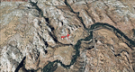
This scenery contains the eastern part of the Grand Staircase Escalante National Monument. It extends from the town of Escalante down south where it connects with the Page/Lake Powell scenery. Contains the upper part of wonderful Escalante Canyon. To explore the scenery depart from Escalante Airport (1L7). Thanks to Joop Mak for providing a custom AFCAD that corrects the airport layout so that it matches with the photo-textures! High resolution versions of this scenery for FS9 and FSX (much sharper, but larger and multiple downloads) are available at www.blueskyscenery.com/CNY_South2West3.html . The screenies are taken from the high-res versions, so expect this version to be slightly more blurry. YourDonation@Work: Dedicated to Jay, Donald and Franz
| Filename: | Grand_Staircase_Escalante_National_MonumentEast_Es.zip |
| License: | Freeware, limited distribution |
| Added: | 4th March 2010, 22:44:30 |
| Downloads: | 1,486 |
| Author: | Gottfried Razek - blueskyscenery.com |
| Size: | 96.2 MB |
| Category: Flight Simulator 2004 - Scenery | |
| PAEN, PAEX, 3AK4, 30AK, 52AK - Alaska, USA |
|
Images related to this file:
File Description:
The town of Kenai is on the east coast of Cook Inlet, 60 miles southwest of Anchorage. The airport is in the northern part of the town, with a runway aligned 1-19, 7,550 feet long and 150 feet wide (with an ILS on 19). A second runway is gravel, 2,000 feet long and for winter use by ski planes. There is also a water runway, and all three are aligned the same and called "1 left-19 right" (the main runway) "1 right-19 left" (gravel) and "1 water-19 water". The taxiways are extensive and designed for a far larger traffic than the airport has today, though even now the airport is fairly busy. In FS9 a water runway for AI cannot work with an ATC control tower; the water part of PAEN has therefore been separated into another call sign PAEX which has ONLY the water runway; the tower will therefore direct the plane that makes contact to use the water runway. The PAEN airport runway has taxiway connections at each end and also two intermediates; at the northern end there are in fact two so a total of 5; B, C, D, E, and F; there is an airport diagram included. GA traffic goes to one of two parking aprons, both at the southern end, and at the far southern end there is the hangar for the Civil Air Patrol. The AI includes aircraft from my previous Alaska posts, as Kenai is where I sent them when they departed from, for instance, Palmer. Airlines and cargo companies that operate from and to Kenai are included in the AI: ERA (which has recently changed it's name), Grant Aviation, Air North, Wings of Alaska, North Star Air, and a small local company Air Supply Alaska, along with Fedex, UPS, Everts, and Northern Air Cargo. There is also GA and float AI. Nearby smaller airfields are included, partly because one of them was dramatically misaligned in FS9.
| Filename: | PAEN_PAEX_3AK4_30AK_52AK___Alaska_USA.zip |
| License: | Freeware, limited distribution |
| Added: | 26th December 2015, 15:33:19 |
| Downloads: | 482 |
| Author: | Roger Wensley |
| Size: | 23.08 MB |
| Category: Flight Simulator 2004 - Scenery | |
| PAKN - King Salmon - Alaska, US V1 |
|
Images related to this file:
File Description:
This is the final version, complete in itself and incorporating the two modifications posted separately. King Salmon is a town with a population of just under 400, on the north bank of the Naknek River and 15 miles from the sea. The airport is adjacent to the town and was originally an airforce base; the military hangars on the airport are still usable. The airport, with its long runway (11-29 and 8,500 feet with an ILS, and a second runway 18-36 and 4,000 feet) is a transportation hub for the area in general and in particular for the salmon industry. Along the Naknek River there are numerous canneries and there are also fishing lodges on the river and nearby lakes; to speed up transportation to the lodges there are float bases on the river to the south of the airport. King Salmon has three tiers of scheduled flights: Alaska Air direct from Anchorage in a 737 (passengers and cargo), PenAir (Saab turboprop) as part of their flights up and down the peninsula, and Grant Air serving nearby small towns. There are also PenAir flights, both scheduled and unscheduled, in smaller aircraft (Piper Navajo for instance) to smaller airports for the fishing season, plus cargo flights in larger aircraft by the lowest bidder (Everts and Northern). To complete the mix the AI includes a pair of F15s. The runways cross (see the airport diagram) so read the notes re long taxi routes. There is AI for PAKN, plus revised AI made for Dutch Harbor which includes flights by PenAir to King Salmon, plus revised parking for Dutch Harbor with new replacement bgls to cater for more flights. There is also AI for the float bases on the river; I have made two runways separated into two float bases for river AI, called King Salmon Floats and King Salmon River; more AI for these will be added when other scenery along the river is made. Just land according to the wind and taxi to whatever dock takes your fancy.
| Filename: | PAKN__King_Salmon__Alaska_US_V1.zip |
| License: | Freeware, limited distribution |
| Added: | 11th April 2015, 06:20:40 |
| Downloads: | 502 |
| Author: | Roger Wensley |
| Size: | 23.67 MB |
| Category: Flight Simulator 2004 - Scenery | |
| Your New Private Airport Complete Package Upgrade 2--Huron Intl Fix |
|
File Description:
By Christian Staycer. This Fix is for private_intl, but if you don't have previous versions, download this. P.S. I figured out how to assign AI flight plans to this airport, with AI Flight Creator and AIFP Utilities. I will release the traffic files soon, but I have to know which "WoAI" aircraft is which. Enjoy!
| Filename: | Your_New_Private_Airport_Complete_Package_Upgrade_.zip |
| License: | Freeware, limited distribution |
| Added: | 18th August 2007, 23:58:54 |
| Downloads: | 227 |
| Author: | Christian Staycer |
| Size: | 4.77 KB |
| Category: Flight Simulator 2004 - Scenery | |
| Ingalls Municipal Airport (30K), Ingalls, Kansas (Sort of a Strange One!) |
|
File Description:
Here is one of the stranger airports in Kansas, Ingalls Municipal...Originally a WWII training field, not much remains except a giant "M" shaped apron and one runway...Made with EZ-Scenery...Extensive "Readme" file included...Freeware use only!
| Filename: | Ingalls_Municipal_Airport_30K_Ingalls_Kansas_Sort_.zip |
| License: | Freeware |
| Added: | 30th December 2005, 20:45:41 |
| Downloads: | 341 |
| Author: | Steve Ziegler |
| Size: | 88.5 KB |
| Category: Flight Simulator 2004 - Scenery | |
| IFR approaches for the new runways in LEMD Madrid-Barajas Airport |
|
File Description:
This is an update of the IFR approaches to Madrid-Barajas Airport. It is intended to use ONLY with our scenery ULTIMATELEMDGBv1.zip uploaded on April 25th 2005.
The file creates the correct ILS and VORDME approaches to the new runways 18L and 33R, and updates those of 18R and 33L, according to the latest information published by AENA (www.aena.es), including transition and missed approaches. New fixes (waypoints) have also been created for the new runways, as needed.
| Filename: | IFR_approaches_for_the_new_runways_in_LEMD_MadridB.zip |
| License: | Freeware |
| Added: | 3rd November 2005, 13:57:28 |
| Downloads: | 8,675 |
| Author: | Joaquín & Miguel Zafra |
| Size: | 227.97 KB |
| Category: Flight Simulator 2004 - Scenery | |
| Luis Munoz Marin International Airport, San Juan, Puerto Rico - Version 2 |
|
File Description:
A major rework of Version 1 following receipt of additional reference material. Includes a redesigned terminal layout and AFCAD2 file to better match the real world. Also removes "skyscraper" default buildings on the east side of the airport and replaces them and others with custom buildings with interior detail. Added optional tree lines and tree clusters. Version 2 Patch for FS2002 is in TJSJJY2a.zip, including an AFCAD file.
| Filename: | Luis_Munoz_Marin_International_Airport_San_Juan_Pu.zip |
| License: | Freeware, limited distribution |
| Added: | 13th May 2004, 21:34:42 |
| Downloads: | 10,628 |
| Author: | John Young |
| Size: | 1.96 MB |
| Category: Flight Simulator 2004 - Scenery | |
| Mc Carran International Airport, Las Vegas, Nevada (KLAS) Instrument Approach Update |
|
File Description:
The package provides current approach procedures including ILS RWY 1L not included in FS9.1. Recent charts (eff thru 2/16/06) are included and source file for bglcomp for use by others detailing the scenery. No scenery except updated Runway 1 Left is included. This updates the maps shown by FS GPS to be flow in accordance with current IAPs.
| Filename: | Mc_Carran_International_Airport_Las_Vegas_Nevada_K.zip |
| License: | Freeware |
| Added: | 2nd February 2006, 03:01:31 |
| Downloads: | 1,710 |
| Author: | Dan Downs |
| Size: | 868.78 KB |
| Category: Flight Simulator 2004 - Scenery | |
| Newport, Oregon - KONP. A conservative enhancement of the Newport, Oregon airport. |
|
Images related to this file:
File Description:
Newport, Oregon - KONP. A conservative enhancement of the Newport, Oregon airport which lies some 130 miles Southwest of Portland, Oregon. Featured is an AI U.S. Coast Guard Helicopter (included in the package) making training and reconnaissance flights over and around the area. Also included is a new bridge allowing the fishing fleet access to and from the bay. Tillamook, which is just North of Newport, is famous for it's cheese but you will find much more to enjoy on this portion of the Oregon coastline. Default, RWY12 and EZ scenery objects were used in this project. Please unzip to a temporary folder and follow the easy installation instructions. Compiled for your flying enjoyment by David "Opa" Marshall.
| Filename: | Newport_Oregon__KONP__A_conservative_enhancement_o.zip |
| License: | Freeware |
| Added: | 31st January 2010, 21:22:48 |
| Downloads: | 4,052 |
| Author: | David "Opa" Marshall |
| Size: | 2.52 MB |
© 2001-2026 AVSIM Online
All Rights Reserved
Privacy Policy |