
Where Flight Simulation Enthusiasts Gather from Around the World!
AVSIM Library - Search Results

| Category: Flight Simulator 2004 - Scenery | |
| FS2004 Scenery World War II Naval Air Stations. |

|
Images related to this file:
File Description:

FS2004 Scenery--World War II Naval Air Stations. Leading up to the Second World War, the United States pursued a rush building program for airship bases. These bases were designed to support fleets of blimps that would patrol its coasts and help protect its vulnurable shipping lanes. Together these bases boasted fourteen airdocks which are widely believed to be the largest free-standing wooden buildings ever constructed. Although time and misfortune have destroyed most of them, this scenery will bring them back in their heyday of the early 1940's. This scenery package contains all eight of these wartime Naval Air Stations; Weeksville, North Carolina (NC), Hitchcock, Texas (TX), Glynco, Georgia (GA), Santa Ana, California (CA), Richmond, Florida (FL), Houma, Louisiana (LA), South Weymouth, Massachusetts (MA), and Tillamook, Oregon (OR). As a bonus for your patience you will also find the seaplane base at Tongue Point OR and a custom scenery addon package of ground crews and vintage vehicles. This is a stand alone scenery package and requires the removal of any and all previous versions. Re-upload of previous file due to library hack. By John Stinstrom.
| Filename: | FS2004_Scenery_World_War_II_Naval_Air_Stations.zip |
| License: | Freeware, limited distribution |
| Added: | 27th May 2010, 09:37:53 |
| Downloads: | 903 |
| Author: | John Stinstrom |
| Size: | 11.09 MB |
| Category: Flight Simulator 2004 - Scenery | |
| Inyokern Airport, Inyokern CA. , USA - Version 3 |
|
Images related to this file:
File Description:

FS2004 Scenery for Inyokern Airport (KIYK). SORRY everyone there were some libraries and textures missing from the recent release. This package contains all missing objects and libraries and is a complete replacement for ANY of my Inyokern sceneries previously installed, no other download required. (Nestled on the sunny side of the southern Sierras, Inyokern is a great jumping-off place for hi desert adventures. Known for decades for it's great soaring spots, Inyokern itself is busy enough with an average of 80 flights a day including it's United/Skywest commuter flights and occasional military traffic from the nearby China Lake Naval Weapons Test Center. Geographically, the airport is situated in the high desert of Southern California, 100 miles east-northeast of the county seat in Bakersfield, 80 miles north-northeast of the Lancaster and Palmdale areas, and 120 miles north-northwest of San Bernardino. The airport itself covers 1,640 acres at an elevation of 2,457 feet, with three asphalt paved runways that can accommodate almost any class of civilian, commercial, or military aircraft. Inyokern Airport is served by commercial airlines connecting through Los Angeles International Airport.)
| Filename: | Inyokern_Airport_Inyokern_CA__USA__Version_3.zip |
| License: | Freeware, limited distribution |
| Added: | 10th November 2013, 23:32:02 |
| Downloads: | 2,057 |
| Author: | John Stinstrom |
| Size: | 6.36 MB |
| Category: Flight Simulator 2004 - Scenery | |
| Farallon Island Chain, Version 4 |
|
File Description:
Beta version 4: Combines North, Middle, and Southeast Farallon Islands into one download. Lighthouse added to Southeast Farallon Island along with the water catchment pad (also serves as helipad). These islands were mysteriously absent from the FS2004 default scenery, probably owing to their small size. When I went to look for them I found a small mountain of water instead of the islands. Most people don't seem to be aware of the Farallon Islands. Located off the coast of California, near San Francisco, they are home to thousands of birds, seals, and some of the largest Great White sharks known to man. All of this is within a very short distance of the city. Today, it is a wildlife refuge and is off limits to visitation by the general public. Those of you interested in more info might check out "The Devil's Teeth" by Susan Casey. These islands were created as scenery objects instead of traditional terrain in order to preserve detail. The terrace on the Southeast Farallon Island is landable now but the terrain is pretty rough. If you're in Timberwolf Aviation and you're doing the multiplayer session on 03/26/2006, this is the version you should get.
| Filename: | Farallon_Island_Chain_Version_4.zip |
| License: | Freeware, limited distribution |
| Added: | 26th March 2006, 21:32:24 |
| Downloads: | 1,834 |
| Author: | Glen Gordon (Prof K.) |
| Size: | 1.51 MB |
| Category: Flight Simulator 2004 - Scenery | |
| Kindley Field Bermuda 1955-1962 |
|
File Description:
Kindley Field, on the British Overseas Territory of Bermuda, was built as a joint RAF/USAAF facility during the Second World War. Subsequently the RAF area became the civilian terminal while Kindley Air Force Base was operated by the USAF between 1948 and 1970. It was primarily a staging post between the US and Western Europe for land-based planes unable to cross the Atlantic non-stop, very like Ernest Harmon in Newfoundland and the civilian Gander, and like Harmon it closed when the jet age made such bases redundant. Prior to that it hosted no combat units, but the 59th and then 53rd Weather Reconnaissance Squadrons, the 'Hurricane Hunters', were based there, and also from 1 February 1956 to 15 June 1963 the 303rd ARS Stratotankers were present to support Strategic Air Command and other refueling requirements. After 1970 it became a US Navy facility primarily concerned with tracking Soviet submarines, and was closed at the end of the Cold War. This scenery represents Kindley between 1955 and 1962 and has custom made scenery by Dan French and ai military traffic by Al Von Pingel to add to the downloadable California Classic civilian and MATS traffic available at Tom Gibson's site. Like Harmon and Gander, it was one of the most important airfields of its time.
| Filename: | Kindley_Field_Bermuda_19551962.zip |
| License: | Freeware |
| Added: | 3rd December 2022, 13:10:38 |
| Downloads: | 147 |
| Author: | Ken Lawson, Al Von Pingel, Dan French |
| Size: | 30.31 MB |
| Category: Flight Simulator 2004 - Scenery | |
| Mesa Verde National Park, Cortez (KCEZ), Colorado, Photo-Scenery (FS9 & FSX) |
|
Images related to this file:
File Description:
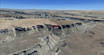
Mesa Verde National Park is famed for its numerous ruins of cliff dwellings built in the 12th century by ancient Pueblo people called Anasazi. Cliff dwellings are highly defensible stone villages situated under alcoves (rock overhangs) along the canyon walls. The largest cliff dwelling in the park is Cliff Palace, which is the largest cliff dwelling in North America. Cliff Palace contained 150 rooms and housed approximately 100 people. Unfortunately you won't see the cliff dwellings from the air, because they are under the cliffs but you will see everything else like all roads, trails and facilities. Very little is known about the Anasazis and the reason for their sudden departure at the end of the 13th century remains a mystery. Theories range from crop failures due to droughts to an intrusion of foreign tribes from the North. The name "Mesa Verde" stems from Spanish explorers seeking for a route from Sante Fe to California. They named the region Mesa Verde (spanish for green table) because of its high, tree-covered plateaus. High resolution versions of this scenery for FS9 and FSX (much sharper, but larger and multiple downloads)
are available at www.blueskyscenery.com/GNB_West2.html . The screenies are taken from the high-res versions, so expect this version to be slightly more blurry. Thanks to Joop Mak for providing custom AFCADs that correct airport layouts so that they align with the photo-textures! They are available at www.blueskyscenery.com/AFCADs.html . YourDonation@Work: Dedicated to David.
| Filename: | Mesa_Verde_National_Park_Cortez_KCEZ_Colorado_Phot.zip |
| License: | Freeware, limited distribution |
| Added: | 1st May 2010, 03:55:31 |
| Downloads: | 1,467 |
| Author: | Gottfried Razek - blueskyscenery.com |
| Size: | 92.87 MB |
| Category: Flight Simulator 2004 - Scenery | |
| KSNA, John Wayne-Orange County Airport |
|
Images related to this file:
File Description:

John Wayne Airport (IATA: SNA, ICAO: KSNA, FAA LID: SNA) is an airport in an unincorporated area in Orange County, California, with its mailing address in the city of Santa Ana, which is also the county seat, hence the International Air Transport Association (IATA) airport code. The main entrance to the airport is off of MacArthur Blvd in Irvine, the city that abuts the airport from the north and east. Newport Beach and Costa Mesa form the southern and western boundaries, respectively, together with a small unincorporated area along the Corona del Mar (73) Freeway. Santa Ana lies just north, not actually touching the airport directly. Originally named Orange County Airport, the county Board of Supervisors renamed it in 1979 to honor the actor John Wayne, who resided in neighboring Newport Beach and died that year. It also became the first airport to be named after an entertainer.
The main runway, at 5,701 feet (1,738 m), is one of the shortest of any major airport in the United States, resulting in most passenger aircraft operating from the airport to be no larger than the Boeing 757. However, some larger cargo aircraft, such as the FedEx A310/300, fly from SNA. Some gates are built to handle planes up to the size of a Boeing 767, which can operate with payload/fuel load restrictions. No wide-body passenger aircraft are currently in scheduled service at the airport.
| Filename: | KSNA_John_WayneOrange_County_Airport.zip |
| License: | Freeware, limited distribution |
| Added: | 11th October 2011, 04:03:32 |
| Downloads: | 4,876 |
| Author: | Mateusz Stabryla MK-Studios |
| Size: | 59.73 MB |
| Category: Flight Simulator 2004 - Scenery | |
| CYCE - James T. Field Memorial at Centralia, Ontario, Canada V1 updated |
|
Images related to this file:
File Description:
This is an updated version of the original post, revising and adding to AI, parking, rear fences, paths from apron to hangar doors, etc. The Lockheed Constellation was downloaded from the web site California Classics, and with the knowledge and permission of Tom Gibson the modified plane is included here complete with its Air Alaska textures and a modified .cfg file so that it will imitate a lightly loaded plane and squeeze the landing run to suit the runway length of 10-28. The airfield is in southern Ontario, 55 miles west of Kitchener and 25 miles northwest of London, close to the shore of Lake Huron. The airfield is ex-military and was previously listed as Huron Airpark before being officially named the James T. Field Memorial; for me it will always be Huron Airpark. The field is owned by Goderich Aircraft Inc, a company that fits out aircraft with new interiors including instrumentation, seating, and paint schemes. Their main customers are business jet owners, which is why the AI here is oriented towards Lear etc. There are now two runways in use, the third being closed and marked as such (though still listed in the AI for you to select one to land on). The main runway is 10-28 and just over 5,000 feet. The second runway is 16-34 and 4,400 feet, with only identification numbers and centreline markings. There appear to be no apron lights, taxiway lights or runway signage currently installed. There is a small club hangar (and club room) adjacent to the main apron at the southern end, with GA parking, and there are two large hangars (one new) used by Goderich at the northern end. The remainder of the original large hangars are now in use as light industrial units unrelated to aviation, the most obvious of which is a garbage collection company with numerous parked garbage trucks. One of the hangars adjacent to the apron does incorporate what appears to be a new set of hangar doors (the red one) but it is unclear if this is actually in use for a plane. The control tower is no longer in use, and there is only limited snow clearance in the winter by Goderich; presumably they only clear it when they need to use it themselves.
| Filename: | CYCE__James_T_Field_Memorial_at_Centralia_Ontario_.zip |
| License: | Freeware, limited distribution |
| Added: | 24th November 2016, 22:20:37 |
| Downloads: | 325 |
| Author: | Roger Wensley |
| Size: | 13.92 MB |
© 2001-2026 AVSIM Online
All Rights Reserved
Privacy Policy |