
Where Flight Simulation Enthusiasts Gather from Around the World!
AVSIM Library - Search Results

| Category: Flight Simulator 2004 - Scenery | |
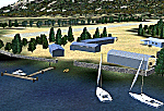
| Lake Hood, Anchorage, Alaska V2 |

|
File Description:
The first version of this scenery was made from satellite images and little knowledge of the ground. Since then, numerous photographs were provided by local residents and this allowed several of the buildings to be done over. This scenery is a little closer to the real thing. I recommend that you also obtain my Summit Lake and Kenai sceneries, the AI Lake Renegade, and Tom Fica's Homer scenery. That will fill out the Anchorage area.
| Filename: | Lake_Hood_Anchorage_Alaska_V2.zip |
| License: | Freeware |
| Added: | 2nd December 2005, 00:23:09 |
| Downloads: | 2,980 |
| Author: | John L. Woodward |
| Size: | 1.88 MB |
| Category: Flight Simulator 2004 - Scenery | |
| Glacier Bay National Park, Alaska |
|
File Description:
Add-on meshes can greatly improve the detail of the FS terrain but often conflict with the inaccurate placement of the other default FS landscape elements, particularly in coastal and mountainous areas. This project showcases new methods and software that allow for semi-automated development of FS landscapes from accurate source data. The files completely replace the default FS landscape of Southeast Alaska's Glacier Bay National Park and the adjacent Lynn Canal area between Juneau and Skagway (N58-60 W134-138), including shorelines, islands, and lakes, as well as glaciers, landclass, man-made features, and a LOD9 (76-m) terrain mesh. Optional AI floatplane traffic at four seaplane bases is included. A LOD10 (38-m) mesh of the same area is available as a separate optional download. FS2002 users please use fs8glbay.zip instead.
| Filename: | Glacier_Bay_National_Park_Alaska.zip |
| License: | Freeware, limited distribution |
| Added: | 16th February 2004, 03:40:31 |
| Downloads: | 17,192 |
| Author: | Holger Sandmann, Jim Keir |
| Size: | 10.43 MB |
| Category: Flight Simulator 2004 - Scenery | |
| PAAT (ATU) - Attu - Alaska, USA |
|
Images related to this file:
File Description:
Attu is AT the western end of the Aleutian chain of islands in Alaska, around 40 miles west of Shemya. There was small village on Attu before the Japanese invasion in mid 1942, but the island is now uninhabited. The Coast Guard Loran navigation station remains in place, though it is no longer in operation and visitors to the island are now either tourists or wildlife experts conducting surveys of numbers of nesting birds, etc. The runway still usable is aligned 02-20 and 5,800 feet long; right hand circuits on 02 to stay away from rising ground to the west. The "terminal" building has lost its sign regarding the Horny Bird, removed in 2010 by one of the last of the station operators, but the building is still there, as are some sheds and shacks that lately were used for the uncomfortable accommodation of bird counters. FS9 has used an incorrect icao identification for Attu but correcting it now would make life complicated so ATU it is and shall remain. I have removed the default FS9 roads that came complete with streetlights and telephone poles and replaced and amended the layout with gravel roads to better resemble real life, though the island shape is at best approximate, as is usual in FS9.
| Filename: | PAAT_ATU__Attu__Alaska_USA.zip |
| License: | Freeware, limited distribution |
| Added: | 2nd March 2015, 20:58:09 |
| Downloads: | 279 |
| Author: | Roger Wensley |
| Size: | 3.27 MB |
| Category: Flight Simulator 2004 - Scenery | |
| PAHT - Amchitka - Aleutians, Alaska - USA |
|
Images related to this file:
File Description:
Amchitka is near the western end of the Aleutian chain of islands in Alaska, around 180 miles west of Adak, and was not included in FS9. There is no small town on Amchitka Island, which is why it was used for atom bomb testing after being closed down as an Air Force base. There are three runways from the 1940's, the largest of which is aligned 07-25 and just over 10,000 feet of overgrown asphalt 300 feet wide. The second runway is aligned 15-33 and 6,000 feet (also 300 feet wide) and the third is 05-23 and 5,000 feet. The whole eastern end of the island is crowded with old munitions storage areas and other military paraphernalia, including old quonset huts; some of those are included here. There are also some old buildings still standing but on their way to becoming piles of old wood or rust, and some of these are included. There is almost no visual information available about Amchitka; even Google Earth has snow obscuring what buildings still exist and where they are, so much of this is at best only approximate apart from the two large hangars. There are no markings, lights, signage, or a control tower.
| Filename: | PAHT__Amchitka__Aleutians_Alaska__USA.zip |
| License: | Freeware, limited distribution |
| Added: | 6th February 2015, 00:06:26 |
| Downloads: | 268 |
| Author: | Roger Wensley |
| Size: | 2.6 MB |
| Category: Flight Simulator 2004 - Scenery | |
| PADK - Adak - Aleutians, Alaska - USA |
|
Images related to this file:
File Description:
Adak is near the western end of the Aleutian chain of islands in Alaska. The closed naval air base buildings are mostly still there and once housed over 6,000; the population is now much reduced to around 320, involved in fishing and a fish processing plant, organising caribou hunts for the tourism industry, running the airport, etc. The runways are long and wide (both are over 7,000 feet) and aligned 23-05 (with an ils) and 18-36. There are flights from Anchorage on Thursdays and Sundays by Alaska Airlines (a 737) and occasional charters from Dutch Harbor by Grant Aviation, 445 miles east of Adak. The Ai included here contains these flights. There are revisions included for Dutch Harbor PADU which provide parking for more Grant planes, as Grant are now also running flights to Akun Island, east of Dutch Harbor; more Aleutian posts to follow.
| Filename: | PADK__Adak__Aleutians_Alaska__USA.zip |
| License: | Freeware, limited distribution |
| Added: | 13th January 2015, 23:32:44 |
| Downloads: | 556 |
| Author: | Roger Wensley |
| Size: | 7.59 MB |
| Category: Flight Simulator 2004 - Scenery | |
| Seldovia PASO in Alaska US |
|
Images related to this file:
File Description:
Seldovia is a small airfield across the Kachemak Bay from Homer, 15 miles to the south. The runway is gravel and without lighting; the runway edges and the apron edges are marked by cones. The runway in real life is aligned 16-34 and is just over 1,800 feet, increased here to 2,200 feet to accomodate FS9 AI plane capabilities. The video is one of a series that are well worth watching and this one demonstrates the technique of short field landing and take off.
There is AI, with flights between Homer and Seldovia. I should mention here that the I can only make scenery to fit into my version of FS9, and probably your version is not exactly the same. Also, you may not have the planes that I have used for AI. Unfortunately I cannot cater for something I do not have myself. Homer PAHO will follow on from this post. If you find an error email me please, and note that my email address has been changed to rogwens at Gmail dot com.
| Filename: | Seldovia_PASO_in_Alaska_US.zip |
| License: | Freeware, limited distribution |
| Added: | 28th July 2021, 03:30:16 |
| Downloads: | 76 |
| Author: | Roger Wensley |
| Size: | 9.66 MB |
| Category: Flight Simulator 2004 - Scenery | |
| PAFE - Kake - Southern Alaska, USA |
|
Images related to this file:
File Description:
This is the terminal for Kake PAFE in southern Alaska. Try not to laugh; Kake is a small town and a bus shelter works very well when there might be just one or two passengers for the only flight of the day. This presumes you have installed Tongass Fjords, one of the three by Holger Sandmann and his team, the other two being Misty Fjords and Glacier Bay.
| Filename: | PAFE__Kake__Southern_Alaska_USA.zip |
| License: | Freeware, limited distribution |
| Added: | 7th July 2013, 16:13:55 |
| Downloads: | 300 |
| Author: | Roger Wensley |
| Size: | 1.43 MB |
| Category: Flight Simulator 2004 - Scenery | |
| Bethel PABE in southwest Alaska |
|
Images related to this file:
File Description:
There are four main northwestern Alaska towns which have good airports and are serviced by Alaska Airlines. From these airports local flights connect to nearby villages, "nearby" in Alaska meaning up to 200 miles away. The northernmost is Barrow. Southwest of Barrow is Kotzebue, then Nome, and the furthest south is this one, Bethel. The town of Bethel has a population of just over 6,000 and is 50 miles from the sea on the Kuskowim River, that splits and forks into many tributaries. Bethel Airport is close to the town and provides the only contact with the rest of Alaska, as there is no connecting highway system. There are scheduled flights by Alaska Airlines, ERA (now called Ravn) and Grant Aviation, plus others such as Ryan Air. There are cargo flights by Everts, Northern, and Lynden, and redistribution onwards to nearby villages by the smaller locally-based planes; all of these are included in the AI. There are two main runways, one just under 6,400 feet and another just under 3,900 feet, both of them aligned 19-1. The third runway is around 1,800 feet and mainly gravel, aligned 11-29. Parking at PABE is on three aprons, the northern for smaller commercial planes of Grant, ERA, Ryan etc, the central for larger planes of Alaska, Northern, Everts, and Lynden, and the southern for a large collection of GA; each apron has further hangars for maintenance companies and smaller operators. There is also another separate apron for the local military and Coastguard. There is not much photographic information available for PABE, and I have never been there; as a result it was impossible to make detailed photographic textures for some of the buildings. However, for most hangars I have made textures of at least the right colour etc based on the information I assembled and if it is green with white trim and side windows then that is how it now appears here. The exceptions are the Alaska Airlines terminal building which has complicated curved elements, and the two military hangars and workshops where I had to settle for an Alaska terminal building from another airport and the same for the military. There are numerous small villages in the vicinity of Bethel, all of them being beside either a river tributary or the coast. There are two Google Earth screenshots to show the villages that are served by the flights from Bethel and that are (mostly) included in the AI. Some of these airfields were not included in FS9 but AI will still operate in and out of Bethel. The smaller area screenshot shows the villages that are close to Bethel, and of these eight I have so far made six and they are included in this post: Napaskiak PKA, Napakiak WNA, Kwethluk KWT, Atmautluak 4A2, Nunapitchuk 16A, and Kasigluk Z09. I will work my way through the rest of the area.
| Filename: | Bethel_PABE_in_southwest_Alaska.zip |
| License: | Freeware, limited distribution |
| Added: | 8th March 2019, 00:37:58 |
| Downloads: | 303 |
| Author: | Roger Wensley |
| Size: | 32.02 MB |
| Category: Flight Simulator 2004 - Scenery | |
| PAUT - Akun Island - Alaska, USA |
|
Images related to this file:
File Description:
Akun Island is close to Akutan, only 7 miles away from the village and the Trident fish processing plant that is just west of the village. Unfortunately those 7 miles are over the sea, as the airport has been built on a different island where there are fewer hills. The link is by hovercraft, which is included as AI in this post along with a "seaport" that boasts only an apron down by the beach. PAUT has a single runway aligned 09-27 which is 4,500 feet long and has a surrounding gravel base. There are daily flights from Dutch Harbor by Grant Aviation, more than one if more are required. The Ai contains these flights, plus a late afternoon Coastguard helicopter flight is added to the revised St Paul Island AI included here. Adjacent to the airport there is a camp for housing labour who were employed on the airport construction, and this is now available for wildlife survey teams or whoever else needs to find accommodation while working on Akun Island.
| Filename: | PAUT__Akun_Island__Alaska_USA.zip |
| License: | Freeware, limited distribution |
| Added: | 27th January 2015, 23:11:43 |
| Downloads: | 472 |
| Author: | Roger Wensley |
| Size: | 4.13 MB |
| Category: Flight Simulator 2004 - Scenery | |
| NZMJ Martins Bay, New Zealand |
|
Images related to this file:
File Description:
Fiordland, New Zealand. 19nm from Milford Sound. You must have Christian Stock's NZ mesh in the form of "Mountains of New Zealand"
and topo in the form of "Lakes and Rivers of New Zealand".
| Filename: | NZMJ_Martins_Bay_New_Zealand.zip |
| License: | Freeware |
| Added: | 13th July 2010, 09:19:02 |
| Downloads: | 358 |
| Author: | Godfrey Tier |
| Size: | 855.99 KB |
© 2001-2026 AVSIM Online
All Rights Reserved
Privacy Policy |