
Where Flight Simulation Enthusiasts Gather from Around the World!
AVSIM Library - Search Results

| Category: Flight Simulator 2004 - Scenery | |
| Faroes Islands mesh and scenery |

|
File Description:
This is, as far as we know, the first non-default mesh of the Faroe Islands and a vast improvement over the default. It is based on the free data made available by Jonathan de Ferranti. The default is not placed correctly so the package includes also new coastlines, land class, streams and other basic elements plus some of the towns and objects on the islands. It will be supplemented later with more towns and other scenery elements.
| Filename: | Faroes_Islands_mesh_and_scenery.zip |
| License: | Freeware |
| Added: | 3rd April 2006, 21:44:59 |
| Downloads: | 2,013 |
| Author: | Jonathan de Ferranti, Ryan Andersen and Peter H. Poulsen |
| Size: | 514.32 KB |
| Category: Flight Simulator 2004 - Scenery | |
| Society Islands, French Polynesia Mesh |
|
File Description:
High-resolution, hand edited mesh of the Society Islands (French Polynesia), LOD 10 3.75 arc second resolution. The single bgl file covers the islands of Tahiti (NTAA), Moorea (NTTM), Huahine (NTTH), Raiatea (NTTR), Bora Bora (NTTB) and Maupiti (NTTP).
| Filename: | Society_Islands_French_Polynesia_Mesh.zip |
| License: | Freeware |
| Added: | 23rd January 2004, 01:04:31 |
| Downloads: | 13,041 |
| Author: | Rolf Keibel |
| Size: | 475.57 KB |
| Category: Flight Simulator 2004 - Scenery | |
| Madeira 76m SRTM Terrain Mesh |
|
File Description:
USGS SRTM 3 arc-second, resampled to LOD9 (76 meters).
This is a terrain mesh scenery of the Island of Madeira west of Morocco, Africa.
Included are the islands of Madeira and Porto Santo.
| Filename: | Madeira_76m_SRTM_Terrain_Mesh.zip |
| License: | Freeware, limited distribution |
| Added: | 4th April 2004, 16:48:40 |
| Downloads: | 13,098 |
| Author: | Andreas Trawny |
| Size: | 522.21 KB |
| Category: Flight Simulator 2004 - Scenery | |
| GERMANY 2004 SRTM MESH SCENERY |
|
File Description:
Based on SRTM 3 arc.sec data.
Unfortunately SRTM DATA have many holes and data loss, so I made a resampling and an oversampling with other data with lower resolution, but with better coverege (like data from swiss topographic federal istitute or from italian IGM, and finally with DTED Level 0.) with geo cad software like Grass and GlobalMapper for projection convertion.
Compression and conversion to bgl with MS Flight simulator SDK at LOD 9
This scenery cover the entire Germany teritory, the part of Swiss and Austria territories not included in my Italian scenery. Parts of Belgium and Netherlands and Luxembourg are included too (Till E005); next quite the whole territory of Czech Republic and part of Poland till E017.
| Filename: | GERMANY_2004_SRTM_MESH_SCENERY.zip |
| License: | Freeware |
| Added: | 23rd November 2003, 23:18:46 |
| Downloads: | 25,893 |
| Author: | Pietro Mauri |
| Size: | 62.08 MB |
| Category: Flight Simulator 2004 - Scenery | |
| "Himalayan Peaks" LOD10 Mesh, Volume 8 - Tirich Mir and Pamir |
|
Images related to this file:
File Description:
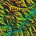
Highly detailed terrain mesh of the Tirich Mir and Pamir areas, N36-39 E71-74. The files in this package are based on Shuttle Radar (SRTM) Version 2 data but with many of the void areas, especially the most significant sections, filled with elevation data generated from topographic maps by Jonathan de Ferranti. While Jonathan's work is unrelated to flight simulation he kindly gave me permission to compile his data for use in FS. The result is a wonderful improvement in detail and accuracy over any existing mesh file, freeware or commercial, based on SRTM or DTED data alone.
Due to the large area of the Himalayas I've compiled the source data as two separate series: the "Himalayan Peaks" series covers prominent mountains and ranges in higher detail and locally overrides any existing LOD9 terrain mesh. In addition, a LOD9 "base mesh" series covering the entire Himalayas will be available for those who do not yet have an add-on terrain mesh of these beautiful mountains.
| Filename: | Himalayan_Peaks_LOD10_Mesh_Volume_8__Tirich_Mir_an.zip |
| License: | Freeware, limited distribution |
| Added: | 29th May 2010, 08:52:47 |
| Downloads: | 9,103 |
| Author: | Holger Sandmann, Jonathan de Ferranti |
| Size: | 47.94 MB |
| Category: Flight Simulator 2004 - Scenery | |
| Colombian Airports - Update |
|
File Description:
This is an update to my previous Colombian Airports upload colapts1.zip.
The update contains mainly some navaid corrections to SKFL, SKIB, and SKVP, and adds the airport SKSJ Jorge E. Gonzales of San Jose del Guaviare; this is now at the correct location and altitude and has buildings, objects, and landclass added. It is for FS9 default scenery and the Colombia freeware mesh by Raimondo Taburet. However, the scenery should also work with the default or any other mesh but I have not tested it.
However, please NOTE:
that in the default scenery without mesh the airport SKSJ will be below the rest of the surface whereas with the mesh, the airport will be at the same altitude as the rest of the scenery with the exception of the river which now runs at a higher (the default) altitude (see screenshots). For me flying without the mesh does not make any sense, so I live with that restriction. If you don't like it, you can always delete or deactivate the files starting with "SKSJ".
| Filename: | Colombian_Airports__Update.zip |
| License: | Freeware |
| Added: | 10th September 2014, 14:50:05 |
| Downloads: | 1,436 |
| Author: | Detlev J. Rohmer |
| Size: | 5.4 MB |
| Category: Flight Simulator 2004 - Scenery | |
| Kantishna Field, Anchorage Alaska. |
|
File Description:
This scenery is located in Anchorage Alaska. All default enhanced.
Airport name,
1.Kantishna(5Z5) default enhanced.
Aircraft involved: NONE.
| Filename: | Kantishna_Field_Anchorage_Alaska.zip |
| License: | Freeware |
| Added: | 25th January 2004, 23:16:06 |
| Downloads: | 1,899 |
| Author: | Frank Betts |
| Size: | 710.63 KB |
| Category: Flight Simulator 2004 - Scenery | |
| Ile d'Aix France Photo real |
|
File Description:
Photo scenery of "Ile d'Aix", small island between La Rochelle and Fort Boyard France.
Includes no mesh but provides customized autogen.
| Filename: | Ile_dAix_France_Photo_real.zip |
| License: | Freeware |
| Added: | 8th July 2006, 13:43:19 |
| Downloads: | 1,725 |
| Author: | Alain Nicco |
| Size: | 344.94 KB |
| Category: Flight Simulator 2004 - Scenery | |
| El Formosa - Taiwan Scenery Project, Part 1 |
|
File Description:
Base pack for el Formosa series sceneries. This el Formosa part 1 includes Taiwan high resolution mesh, new coastline & road modification.
| Filename: | El_Formosa__Taiwan_Scenery_Project_Part_1.zip |
| License: | Freeware, limited distribution |
| Added: | 24th October 2010, 07:11:14 |
| Downloads: | 10,564 |
| Author: | Formosa Group |
| Size: | 9.96 MB |
| Category: Flight Simulator 2004 - Scenery | |
| SRTM Terrain Mesh(LOD9) of China Middle (Part 5 of 6) |
|
File Description:
76m (LOD9) SRTM mesh of China. East(6 files), Middle(6 files) and west(6 files) all China 18 in TOTAL.
| Filename: | SRTM_Terrain_MeshLOD9_of_China_Middle_Part_5_of_6.zip |
| License: | Freeware |
| Added: | 24th August 2005, 23:45:28 |
| Downloads: | 4,966 |
| Author: | TANTRiS (Ho, Chong Yun) |
| Size: | 45.87 MB |
© 2001-2026 AVSIM Online
All Rights Reserved
Privacy Policy |