
Where Flight Simulation Enthusiasts Gather from Around the World!
AVSIM Library - Search Results

| Category: Flight Simulator 2004 - Scenery | |
| Guangdong Pearl River Delta Landclass - China |

|
File Description:
These are landclass files of the Pearl River Delta area, located in the south of China's Guangdong province.
This area is one of the biggest metropolitan areas (or megacity) in the world today, and as it was poorly represented in FS2004, I decided to 'map' it using EZ-landclass and images from Google Maps.
The area that was mapped stretches as far north as the New Bayiun Airport, all the way to the islands south of Hong Kong, and to the mountain ranges east and west of the Delta; with big cities included being: Guangzhou, Foshan, Dongguan, Jiangmen, Huizhou, Shenzen, Zhongshan, Zuhai, Macau & Hong Kong.
Only tested in FS9 but should work in FSX as well.
| Filename: | Guangdong_Pearl_River_Delta_Landclass__China.zip |
| License: | Freeware |
| Added: | 17th April 2016, 19:11:40 |
| Downloads: | 487 |
| Author: | Leonardo Santos |
| Size: | 6.92 KB |
| Category: Flight Simulator 2004 - Scenery | |
| Long Beach KLGB Version 4.0 (New Terminal Construction) |
|
Images related to this file:
File Description:

This is a transitional version of Long Beach Daugherty Field. A brand new terminal is currently under construction and due to open in 2013. This version of the scenery shows the terminal as built but not yet operational which reflects current operations as of November 2012. All parking stands have been moved from their original staggered locations to positions surrounding the new terminal complex. Airlines serving the airport have been updated, and other heavy modifications have also taken place. In addition, Signal Hill has been converted from the giant rock scenery object to a correct elevation change file. The hill now has autogen and proper positioning and elevation. A future update with the fully operational terminal will be forthcoming.
| Filename: | Long_Beach_KLGB_Version_40_New_Terminal_Constructi.zip |
| License: | Freeware |
| Added: | 28th October 2012, 12:58:03 |
| Downloads: | 2,631 |
| Author: | FRFStudio.net / William Morgan / Sheryar Ansari |
| Size: | 81.5 MB |
| Category: Flight Simulator 2004 - Scenery | |
| Ultimate Madrid Gran-Barajas V3 (FsHispanic) |
|
File Description:
We have paid a lot of attention to details and accuracy in this third version of our scenery.
The scenery reconstructs all taxiways and aprons (some in concrete and some in asphalt, as in reality), and adds the new runways and associated taxiways. More than 300 taxisigns are included. Navaids are also updated.. All based on the recently published most-updated information by AENA for February 05th 2006, including last-minute changes. Two new ILSs are in place, IML (for runway 18L) and MBB (for runway 33R), and the old ILSs have disappeared.
Gates have been asigned in the airport according to the most present information. Comm frequencies have been revised and modified accordingly.
| Filename: | Ultimate_Madrid_GranBarajas_V3_FsHispanic.zip |
| License: | Freeware |
| Added: | 15th January 2006, 07:15:50 |
| Downloads: | 33,424 |
| Author: | Joaquin and Miguel Zafra |
| Size: | 6.66 MB |
| Category: Flight Simulator 2004 - Scenery | |
| Bangkok Thailand VTBD |
|
File Description:
This scenery incorporates everything I have learned about scenery design. It is a major re-work of my previous scenery for Bangkok, which first came out over two years ago. Most airport buildings have been modeled and placed using numerous photographs and assistance from local sources, as well as the AIP for Thailand. I have also created a large part of the city, including major landmark buildings and several elevated helipads. The Chao Phraya River and many landmark parks and golf courses have been added using Ground2K. A custom AFCAD2 file is included. I have made extensive use of library objects and "LOD" models to keep the framerates reasonable, despite the higher detail compared with previous versions.
| Filename: | Bangkok_Thailand_VTBD.zip |
| License: | Freeware, limited distribution |
| Added: | 29th November 2003, 11:42:36 |
| Downloads: | 30,586 |
| Author: | Martin Strong |
| Size: | 8.59 MB |
| Category: Flight Simulator 2004 - Scenery | |
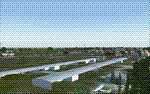
| Spokane GEG / KGEG, Version 2.0 |
|
Images related to this file:
File Description:

Thank you for downloading my scenery. This is an update to the default Spokane Int'l airport. All default buildings have been removed and replaced. The terminals have been modeled according to sat photos and are close to photoreal. The included AFCAD has accurate parking and has the new parallel taxiways in place as well as all taxiway signs.
This scenery was built using Abacus' EZ-Scenery program.
Update:
The Cargo ramp has been redesigned to be more accurate. Due to a lack of information, Version 1 did not have buildings or airlines accurately placed. With the arrival of detailed accounts from a user, John S. Morgan, parking positions and building placement have been corrected.
| Filename: | Spokane_GEG__KGEG_Version_20.zip |
| License: | Freeware |
| Added: | 20th May 2010, 09:01:34 |
| Downloads: | 4,829 |
| Author: | William Morgan, FRFSTUDIO.NET |
| Size: | 10.89 MB |
| Category: Flight Simulator 2004 - Scenery | |
| PABR - Barrow - Alaska, USA |
|
Images related to this file:
File Description:
The town of Barrow is in the far north of Alaska, and is best known in flying circles as the place where Wiley Post crashed his floatplane on takeoff and killed himself and Will Rogers. The crash was some 15 miles south of Barrow and was "assisted" by the mismatched fuselage, wings, and floats that had been assembled to create the floatplane. The Barrow population is largely Inupiat and totals some 4,400. The downtown area of Barrow is immediately north of the airport. The second and largest part of Barrow is further north past a string of lagoons and is locally called Browerville. To the northeast along the coast is the smallest part around what used to be the Naval Arctic Research Lab, and is now a college. To the east of this are the DEW buildings, plus two large navy hangars and the gravel runway that was used to serve the DEW station. The PABR runway is aligned 06-24 in FS9 and is 7,100 feet long and 150 feet wide, built on top of a gravel base and surround that copes with the underlying permafrost. There is PAPI at both ends and an ILS and approach lights on 06; 06 circuits are to the right. The airport notes include a warning that the apron is not a standard width and that large planes that are enroute to the far end of the runway will not be able to taxi past a plane parked at the gate and should use the runway as a taxiway, then turn and takeoff. FS9 AI cannot cope with that, so the apron here is wider. There are, in real life and the AI, daily flights by Air Alaska (three at least) and Era (several, and which is now called Ravn, hence the new hangar door motif) and air cargo flights by Northern Air Cargo and Everts, plus GA. The buildings have been made with photographic textures or textures made from reference photos. I decided that while 500+ scenery objects was probably ok for most people the required 900+ to "make" the town of Barrow would likely not be. The auto-generated FS9 town objects could not be left as Barrow with trees would not look at all like reality; I have "faded" the density of the town buildings into the distance from the airport.
| Filename: | PABR__Barrow__Alaska_USA.zip |
| License: | Freeware, limited distribution |
| Added: | 17th May 2016, 09:32:36 |
| Downloads: | 971 |
| Author: | Roger Wensley |
| Size: | 15.12 MB |
| Category: Flight Simulator 2004 - Scenery | |
| CNZ3 - Chatham-Kent - Ontario, Canada V1 |
|
Images related to this file:
File Description:
This is partly part of the Small Ontario Fields series. The airport ICAO was changed from CNZ3 to CYCK in November 2012; I have left it as it was. The runway too remains as it was a few years ago. Chatham is located 50 miles east of Detroit and 150 miles southwest of Toronto, between Lake St. Clair and Lake Erie, and the airfield is southeast of the town. There is a single asphalt runway 5,000 feet long and 75 feet wide, aligned 05/23 in FS9 but in fact in real life now 06/24 due to the wandering magnetic north. The apron is on the northern side of the runway at the eastern end, with added taxiways to cater for newer hangars wearing identical colour schemes. There is fuel, runway lighting, some taxiway lights, visitor parking on the grass, and plane maintenance in the large hangar beside the small terminal building on the north side of the apron. There is a train station in the middle of the town, and no scheduled flights to the airport that is 8 miles away; these two facts may be connected. Ditches along the road and around much of the airfield provide separation, which is why the fences are not continuous. If you are on the runway and find your path to the apron blocked by another plane that is stationary at the hold short, continue past the first turnoff to the threshold markers and turn off the runway and wait. The AI plane will then taxi out and you will have a clear path.
| Filename: | CNZ3__ChathamKent__Ontario_Canada_V1.zip |
| License: | Freeware, limited distribution |
| Added: | 27th August 2015, 21:02:59 |
| Downloads: | 341 |
| Author: | Roger Wensley |
| Size: | 9.89 MB |
| Category: Flight Simulator 2004 - Scenery | |
| Zion National Park North, Cedar Breaks National Monument, Cedar City (KCDC), Utah, Photo-Scenery (FS9 & FSX) |
|
Images related to this file:
File Description:
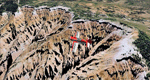
Cedar Breaks National Monument is a large amphitheater cliff in bright colors of red, orange and purple.
It lies east of Cedar City in the northern region of the scenery. The cliff was formed by erosion thru wind,
water and ice. Today erosion continues with a pace of about 2 inches every 5 years. Although it is called
Cedar Breaks, there are no cedars growing there but juniper trees. For a scenic flight to Cedar Breaks
National Monument best depart from Cedar City Regional Airport (KCDC) and head east. The scenery extends
south to Zion National Park and covers a large part of Zion Canyon and the Kolob Canyons area.
Zion National Park is another place where erosion of the Colorado Plateau formed the most beautiful colorful
stone formations of unique and wonderful shapes. There are nine different layers of stone visible in the park.
Most of them consist of sandstone. But there is also limestone, gypsum, siltstone, shale, clay and mudstone.
The Virgin River cut a spectacular and famous canyon thru Zion Park that is as narrow as 20ft and up to 2000ft tall.
High resolution versions of this scenery for FS9 and FSX (much sharper, but larger and multiple downloads)
are available at www.blueskyscenery.com/CNY_South2West5.html . The screenies are taken from the high-res versions,
so expect this version to be slightly more blurry.
Thanks to Joop Mak for providing a custom AFCADs that correct airport layouts so that they align with the photo-textures!
They are available here: www.blueskyscenery.com/AFCADs.html . YourDonation@Work: Dedicated to Richard, P.J. and Felix.
| Filename: | Zion_National_Park_North_Cedar_Breaks_National_Mon.zip |
| License: | Freeware, limited distribution |
| Added: | 14th March 2010, 00:30:28 |
| Downloads: | 1,564 |
| Author: | Gottfried Razek - blueskyscenery.com |
| Size: | 97.13 MB |
| Category: Flight Simulator 2004 - Scenery | |
| Wilgrove Airpark (8A6) |
|
Images related to this file:
File Description:
Wilgrove Airpark (8A6) is a small GA airport located just east of Charlotte, NC. It is often forgotten by pilots in Flightsimulator, yet it is a very busy place in the real-world, due to it's huge popularity with student and weekend GA pilots. There has never been a really good, accurate representation of this little gem created for the flightsim, so I decided to try my hand at it. This is my very first scenery project, and I hope you enjoy it. It was designed with ADE9X, and it requires RWY12 and EZ-Scenery objects extensively,(not included) so you will need to download these freeware scenery libraries prior to installation of this package for the Wilgrove Airpark scenery to display properly. - Glenn Mullis
| Filename: | Wilgrove_Airpark_8A6.zip |
| License: | Freeware, limited distribution |
| Added: | 22nd September 2010, 16:59:32 |
| Downloads: | 278 |
| Author: | Glenn Mullis |
| Size: | 4.4 MB |
| Category: Flight Simulator 2004 - Scenery | |
| KSBA New JUN08 AFCAD w/ Al Wheeler's objects |
|
File Description:
Contemporary KSBA, Santa barbara Municiple Airport scenery as of June 2008 with Scenery object by Al Wheeler.With wheeler's scenery objects, this scenery is packed individually, ready to use by itself. Installtion guide included. Changes included: 1) New taxiway M, K & P
2) original Alpha 07 end curve became P and A extended to the end of rwy 25
but the length of 25 did not change becuse it is "moved forward"
3) J and G near 25 is widen
4) 3 Helipads
5) Grass sides
6) closed link on the end of A and D
7) added taxi signs, you will never get lost a gain
hope you like it and log in to KSBA in vatsim - By James Luen
| Filename: | KSBA_New_JUN08_AFCAD_w_Al_Wheelers_objects.zip |
| License: | Freeware |
| Added: | 16th June 2008, 19:43:14 |
| Downloads: | 1,862 |
| Author: | James Luen |
| Size: | 5.46 MB |
© 2001-2026 AVSIM Online
All Rights Reserved
Privacy Policy |