
Where Flight Simulation Enthusiasts Gather from Around the World!
AVSIM Library - Search Results

| Category: Flight Simulator 2004 - Scenery | |
| Libyan military air bases |

|
Images related to this file:
File Description:

This package contain 25 Libya military airport scenery. For fully functionality you need some object libraries (listed inside).
You can download Libyan AI repaints, and flightplans, from this site and from www.militaryaiworks.com.
Inside: HL0M AL BUMBAH NORTH, HL0O AL JUFRA, HLLB BENINA [Benghazi], HLLQ EL BEIDA [LABRAQ], HL0L GAMAL ABD EL NASSER [Tobruk], HLTD GHADAMES EAST, HLGT GHAT,HL0B MARTUBAH, HL0V MISURATA, HLLM MITIGA [UMM AITIQAH], HL0W OKBA IBN NAFA, HLLS SEBHA, HLGD SIRTE [Ghurdabiya-Sirte], HLLT GAMAL ABDEL NASSER, HL0E MATAN AS SARRA.
| Filename: | Libyan_military_air_bases.zip |
| License: | Freeware |
| Added: | 20th March 2011, 20:25:45 |
| Downloads: | 1,736 |
| Author: | Luciano Franchini |
| Size: | 3.05 MB |
| Category: Flight Simulator 2004 - Scenery | |
| Moncton, New Brunswick, CYQM, 1955-1957 |
|
File Description:
In the period after 1945 Moncton was an important alternate airport for commercial aircraft flying the North Atlantic route between Europe and the U.S.A and Canada. Like Sydney and Goose Bay, it was in a sense a satellite of the much better known Gander, which was however sometimes rendered unusable by adverse weather conditions and especially fog. This scenery is primarily intended for use in the California Classic retro environment created by Tom Gibson and the CalClassic Community, and awaits your Stratocruisers, Douglases and Constellations.
| Filename: | Moncton_New_Brunswick_CYQM_19551957.zip |
| License: | Freeware |
| Added: | 7th January 2023, 01:28:38 |
| Downloads: | 107 |
| Author: | Ken Lawson |
| Size: | 7.34 MB |
| Category: Flight Simulator 2004 - Scenery | |
| VTBD 1961 Bangkok Intl. Don Muang |
|
File Description:
The airport was officially opened as a Royal Thai Air Force base
on March 27, 1914, although it had been in use earlier.
Commercial service to Don Mueang began in 1924.
The first commercial flight was an arrival by KLM.
The airfield was used by the Japanese during World War II,
and was bombed and strafed by Allied aircraft on several occasions.
During the Vietnam War, Don Muang Royal Thai Air Force Base was a
major command and logistics hub of the United States Air Force.
| Filename: | VTBD_1961_Bangkok_Intl_Don_Muang.zip |
| License: | Freeware |
| Added: | 16th March 2008, 05:42:06 |
| Downloads: | 3,384 |
| Author: | Wolfgang Gersch, Jaap de Baare and Tom Gibson |
| Size: | 2.26 MB |
| Category: Flight Simulator 2004 - Scenery | |
| FSE Scenery, W29, Bay Bridge |
|
File Description:
Scenery for W29, Bay Bridge, Kent, Maryland for use with FS2004 and Lagos new FLight Simulator Enhancer (FSE). I've made this far nicer than the place really is but I wanted a test bed to get reaquainted with the FSE interface and a place to try out some of the new features of FSE. It looked too nice to sit on the shelf tho so I thought I would share and make this number one in the PAMDVA series for FS2004. Here you'll find beautiful full seasonal sound which varies as you move about the airport. You'll also find 4 dynamic scenery tracks (two birds gliding overhead, a car that drives about the airport, and a cruising motorboat that plies the waves off the end of the runway. Some seasonal textures are used as well so that it looks correct in all 4 seasons. Many many details but EXTREMELY frame rate friendly. In fact, on my AMD 2600+ with 512 MB ram, and FX5900 I saw no loss at all. Lagos FSE for 2004 required. FSGenesis US Landclass highly recommended (freeware or payware versions.) Enjoy!
| Filename: | FSE_Scenery_W29_Bay_Bridge.zip |
| License: | Check within download |
| Added: | 28th December 2003, 18:35:43 |
| Downloads: | 1,650 |
| Author: | Lauren Robison |
| Size: | 784.39 KB |
| Category: Flight Simulator 2004 - Scenery | |
| Legnano scenery - Italy |
|
Images related to this file:
File Description:
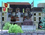
Homage to my town, scenery built mainly with existing objects, buildings by sintax and few experiments by GMax. It DOES NOT include any airport, but represents some pictures of Legnano town
Informations: Legnano is a town in north of Italy (approx 25 kmt NW Milan, ref coordinates N45 35.98 E8 54.59), reachable from Casorezzo ultralight airport (closest one) or all the near others of Milan area.
Here was done in 1176 the historical fight of the Alliance Lombarda's city-states against Federico Barbarossa German imperator. Legnano is also well known for his metallurgical and textile industries story.
Contents: rev.1 : down town square with municipal Palazzo Malinverni and S. Magno basilica, skyscraper, one of Olona river's bridges, G. Mari football stadium, Alberto da Giussano circus with related monument, encircled by the eight quarter's flags, F. Tosi and Manifattura industrial buildings, Rail station, external parking and glass building
rev.2 : Courthouse building with Teresa's face bronze statue and some more buidings, Palio hystorical figurants inside the stadium, Carroccio and Alberto da Giussano rider, Small goods train on railroad; S. Magno belltower reviewed, red sky-lights on top of skyscraper and chimney, Chimney smoke
| Filename: | Legnano_scenery__Italy.zip |
| License: | Freeware |
| Added: | 27th March 2011, 02:55:40 |
| Downloads: | 648 |
| Author: | Aldo Della Vedova |
| Size: | 6.83 MB |
| Category: Flight Simulator 2004 - Scenery | |
| Kanab (KKNB), Utah/Arizona, Photo-Scenery (FS9 & FSX) |
|
Images related to this file:
File Description:
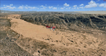
This scenery covers the southwestern part of Grand Staircase-Escalante National Monument. From the air
you can see all the "stairs" from the Pink Cliffs of Bryce Canyon in the north down to the Grey Cliffs,
the White Cliffs and the Vermillion Cliffs just north of Kanab and then the Chocolate Cliffs further south.
Nothwest of Kanab you can fly above beautiful Coral Pink Sand Dunes State Park which features coral-hued
sand dunes located beside red sandstone cliffs. These dunes consist of sand that formed thru erosion of
pink colored Navajo Sandstone surrounding the park and was deposited by wind. To explore the scenery depart
from Kanab Airport (KKNB).
High resolution versions of this scenery for FS9 and FSX (much sharper, but larger and multiple downloads)
are available at www.blueskyscenery.com/CNY_South3West4.html . The screenies are taken from the high-res versions,
so expect this version to be slightly more blurry. Thanks to Joop Mak for providing custom AFCADs that
correct airport layouts so that they align with the photo-textures! They are available at
www.blueskyscenery.com/AFCADs.html . YourDonation@Work: Dedicated to Jesper, Fabrizio and Glen.
| Filename: | Kanab_KKNB_UtahArizona_PhotoScenery_FS9__FSX.zip |
| License: | Freeware, limited distribution |
| Added: | 10th March 2010, 22:24:53 |
| Downloads: | 1,506 |
| Author: | Gottfried Razek - blueskyscenery.com |
| Size: | 95.36 MB |
| Category: Flight Simulator 2004 - Scenery | |
| Iqaluit CYFB 2010 |
|
Images related to this file:
File Description:
Founded in 1942 as an American airbase, Iqaluit is now the capital city of the northern Canadian province of Nunavut. It is the smallest Canadian capital in terms of population and the only capital that is not connected to other settlements by a highway. The airport is of critical importance to the community, especially when ice makes boat travel impossible. At 62 degrees latitude (approx. the same as Yellowknife), Iqualuit offers some of the most severe weather you are likely to encounter at any airport, and has been used for cold weather testing of new airliners.
This version of Iqaluit is a complete rebuild of the default version. Almost all the buildings have been custom modeled based on photos. The design of the terminal building at Iqaluit is one of the coolest I've seen, and was the main inspiration for making this scenery. Due to its complexity many details had to be omitted, but hopefully I was able to at least capture some of its "Yellow Submarine" uniqueness. Ramp lights, fences, ground objects, arrestor cables (non-functional) and all the rest of the usual junk is included. Also Instrument Approach Plates.
| Filename: | Iqaluit_CYFB_2010.zip |
| License: | Freeware |
| Added: | 26th December 2010, 15:38:20 |
| Downloads: | 2,685 |
| Author: | Sidney Schwartz |
| Size: | 4.18 MB |
| Category: Flight Simulator 2004 - Scenery | |
| Gander CYQX in Newfoundland Canada |
|
Images related to this file:
File Description:
Gandeer is on the east coast of Canada and is the closest North American airport to Europe on the great circle route. In the early days of transatlantic flight, and in fact into the 1960's, this made it very important as a refueling stop either before the ocean hop or just after. Since then it's importance as an airport has faded somewhat as planes now fly directly to the larger city destinations. It is still an active air force base for ocean patrol and search and rescue planes, and military flights are around half of the total flights into and out of the airport. The main attractions of the airport now are the long runways and the cheaper landing fees, and there are some cargo flights and cheap charter passenger flights. This version of Gander is based upon a forgotten-about video taken in October 2010. By then the two longer runways, 13-31 at 8,900 feet and 03-21 at 10,200 feet (though in FS9 this is still designated 04-22, as it had been in 2003) had been closed (one at a time) and totally resurfaced. The third runway 09-27 (3,500 feet in 2003) was closed and starting the process of being broken up, along with associated aprons. This was part of a long process of demolition of some of the older buildings, aprons, and taxiways as they became unused with the fall in the number of daily flights. I have made it clear which of the 2010 taxiways and aprons were still in use by showing them as asphalt, while those in the process of decaying disuse or removal are in the darker tarmac texture; this is somewhat realistic as when asphalt aprons are "ploughed" for removal the darker underside becomes visible. In the renovation process of taxiway repairs only the centre strip of the taxiways was repaired and this is marked by new and closer edge lines. One end of the closed runway was still being used in 2010 for access and parking. There is a warning note in the April 2010 edition of the NAV CANADA Flight Supplement that states "surface rut on Gander Flight Training's private taxiway" (written with extremely shortened words). The Gander layout page is included here, showing that in the Spring of 2010 a much-shortened version (1,875 feet) of the 09-27 runway was still in use; my version is for late 2010 and after that runway was closed. The older buildings (and some of them are now 70 years old or more) are built in concrete and flat roofed with bitumen water proofing; hence the almost black roofs. The terminal building is one of these, though it has been enlarged by the inclusion of a hangar that is now used as the main terminal space. Almost all of the buildings are correctly replicated here. The main GA parking area is to the east of 03-21 where there are two large hangar buildings. One of them is for maintenance and the other is for a large FBO called Gander Aviation. There are other FBO's on the airport, closer to the terminal. These are Irving and Woodward, both to the west, and Allied to the south. There is a further FBO at the eastern end of the apron, name unknown. Shell, who only did refueling, were next to Woodward in 2010 but left, I believe, in 2012. The large red building behind Woodward and Shell is for the maintenance of all airport equipment (from luggage trolleys, snow clearers, de-icing trucks etc to air conditioning, radar, and radios). Most of the remaining buildings are for the air force base, though there are some private companies (such as Universal Helicopters) and even a small private cottage.
| Filename: | Gander_CYQX_in_Newfoundland_Canada.zip |
| License: | Freeware, limited distribution |
| Added: | 29th April 2020, 19:15:01 |
| Downloads: | 667 |
| Author: | Roger Wensley |
| Size: | 29.37 MB |
| Category: Flight Simulator 2004 - Scenery | |
| BFU Red Lake |
|
File Description:
BFU Red Lake signifies another expansion of Bush Flying Unlimited. This time into the wilderness of Northern Ontario. Located near the Ontario/Manitoba border this office is located on the tarmac of the Red Lake airport (CYRL). Located 148 miles NE of Winnipeg Intl. and 256 miles southeast of BFU Manitoba this new base will allow us to expand our air services into these remote areas. A new dock and pilot bunkhouse have been constructed by the lake to give our pilots a place to stay when they're working.
| Filename: | BFU_Red_Lake.zip |
| License: | Freeware |
| Added: | 23rd February 2004, 23:34:42 |
| Downloads: | 3,571 |
| Author: | Andrew Langer |
| Size: | 1.92 MB |
| Category: Flight Simulator 2004 - Scenery | |
| Laconia, New Hampshire - KLCI - lake elevation correction |
|
File Description:
Runway 8 at the Laconia, New Hampshire - KLCI - is situated quite close to a lake. The elevation of the lake in FS2004 is such that it presents a "cliff" of water in the default setting. (see "before" screenshot). This package contains a simple flatten file which brings the lake down to the elevation of the airport and corrects a floating building issue also (see "after" screenshot). Please unzip to a temporary folder and follow the very simple installation instructions. Created with Steve Greenwood's FSTflatten program by David "Opa" Marshall for your flying enjoyment.
| Filename: | Laconia_New_Hampshire__KLCI__lake_elevation_correc.zip |
| License: | Freeware |
| Added: | 20th November 2008, 02:27:08 |
| Downloads: | 593 |
| Author: | David "Opa" Marshall |
| Size: | 116.12 KB |
© 2001-2026 AVSIM Online
All Rights Reserved
Privacy Policy |