
Where Flight Simulation Enthusiasts Gather from Around the World!
AVSIM Library - Search Results

| Category: Flight Simulator 2004 - Scenery | |
| Doha, Qatar - Photoreal and Autogen |

|
Images related to this file:
File Description:
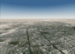
Doha is the capital city of the state of Qatar. Located on the coast of the Persian Gulf, it had a population of 998,651 and is also one of the municipalities of Qatar. The scenery covers the whole city of Doha and the surroundings, with the new airport under construction and "The Pearl", an artificial island built in the bay of Doha which is involved in a huge residential development. The autogen, with buildings, skyscrapers and vegetation, is included in the scenery.
| Filename: | Doha_Qatar___Photoreal_and_Autogen.zip |
| License: | Freeware |
| Added: | 4th June 2013, 21:49:11 |
| Downloads: | 4,163 |
| Author: | Luca Esposito, Fabio Ferrari |
| Size: | 76.26 MB |
| Category: Flight Simulator 2004 - Scenery | |
| Maroc_sc_Supplement |
|
File Description:
These files are for anyone who has installed Toni Agramont's scenery files for Morocco (maroc_sc.zip - available from a number of FS sites on-line: a web search will easily locate them) and wants to remove the static aircraft from the airport sceneries. A large number of these planes are unpainted, so appear as white 'ghosts', and also can end up being superimposed upon dynamic FS9/Ultimate Traffic etc. AI traffic at a number of locations. A few other small alterations ...
| Filename: | Maroc_sc_Supplement.zip |
| License: | Freeware |
| Added: | 6th November 2009, 08:36:21 |
| Downloads: | 6,396 |
| Author: | Martin Stebbing |
| Size: | 963.19 KB |
| Category: Flight Simulator 2004 - Scenery | |
| Glenorchy Airfield, New Zealand. NZGY. |
|
File Description:
Welcome to Glenorchy, a small rural airfield, 2 nautical miles south of the small village of Glenorchy,
on the shores of the beautiful Lake Wakatipu, in the South Island of New Zealand.
Glenorchy is only a very short flight from Queenstown Airport (NZQN), at the opposite end of Lake Wakatipu.
This scenery was built to fit into Robin Corn's freeware "Queenstown area Photoreal Scenery", freely
available on avsim.com ( filename.. nzqnv1.5.zip ).
Requires some EZ Scenery object sets (see INSTALL instructions for details).
| Filename: | Glenorchy_Airfield_New_Zealand__NZGY.zip |
| License: | Freeware, limited distribution |
| Added: | 12th September 2008, 09:06:11 |
| Downloads: | 1,008 |
| Author: | Lawrie Roache |
| Size: | 2.12 MB |
| Category: Flight Simulator 2004 - Scenery | |
| FS9 Fort St John CYXJ in BC Canada |
|
File Description:
Fort St John is close to the border between British Columbia and Alberta, around 40 miles north-northwest of Dawson Creek. The airport was originally a Royal Canadian Air Force base, associated with the wartime construction of the Alaska Highway. The airfield was part of this construction effort and the wartime ferrying of planes to Russia. It is currently named "North Peace Regional Airport", or "North Peace Airport"; apparently there has been no final decision?
The date for this scenery is around 2006. I was given an old video tape cassette which was filmed on an uncertain date, but which had to be before the terminal building was renovated in 2007 and totally changed in appearance. The only way to view the video was to play it in the camera and watch it on a small screen. After I had completed everything except the buildings I started to view the video to establish the building appearances and within an hour or so the camera died. It was so old there was no way to repair it, so I then made some new buildings from memory of the video and what was available online. I also used some that I had already made for other scenery but which were similar. I may replace the terminal building that is in this version with a build of the new one, as I know this one is not a very accurate reproduction. The replacement, if I do it, will be towards the end of this year.
The AI included here is for GA, Air Canada Jazz, and two helicopter companies that were (and still are?) based there. One is at the western end of the apron and the other is at the eastern end but separated from the apron. To gain access to the taxiways and runways (so that all airport users follow the same procedures, for safety reasons) the eastern end helicopters just taxi across the grass. The helicopters are used for maintenance trips to the oil and gas fields in the surrounding area. My screenshots show Westjet at the terminal; this is because I have later Canadian AI installed, while the AI included here is only for the time around 2000 to 2010, when Westjet were not flying to Fort St John.
The airport is square in plan, with the apron running along the northern side and two runways forming diagonals. The two runways are 11-29 (6,882 feet long and 200 feet wide, with ILS at the 29 end and PAPI at the other) and 02-20 (6,684 feet long and 200 feet wide, and with PAPI at each end). The eastern side taxiway that runs north-south is not used. The western side taxiway is in use but only as a race track for cars.
Please email me if you find faults, such as a plane without textures.
| Filename: | FS9_Fort_St_John_CYXJ_in_BC_Canada.zip |
| License: | Freeware, limited distribution |
| Added: | 10th October 2022, 14:03:38 |
| Downloads: | 211 |
| Author: | Roger Wensley |
| Size: | 37.49 MB |
| Category: Flight Simulator 2004 - Scenery | |
| Alaska North Slope 9; Point Hope PAPO |
|
Images related to this file:
File Description:
The town of Barrow is in the far north of Alaska, and these are coastal villages or radar installations to the west, south, and east of Barrow on the North Slope. There will be further additions. Point Hope is a village on a spit of land that is one of the oldest and continuously inhabited places in all of North America, not just the polar regions. The "Point" is what brought this about, migrating whales passing close to land as they rounded the point, and the traditional way of life continues to this day. The population is now around 670. The airport surpassed all my expectations of FS9. Go look at the area before you install this. The first thing you will notice is that FS9 does not list Point Hope PAPO. The town is there (way too big and in totally the wrong place) and the airport background is there (wrong place of course) but there is no airport! Some buildings, but no runway, no apron, nothing that can be used by a plane?!? In real life the town is 3 miles east of the point, the runway is situated between town and point and, unusually in the north, is asphalt. This is presumably possible because of the gravel make-up of the point itself, with very little vegetable content and the warming sea restricting permafrost movements. 4,000 feet of 75 feet wide asphalt, lit, PAPI at both ends, and aligned 01-19. The building that appears to be wrongly situated away from the apron is like that intentionally; it is a helicopter hangar (not used in winter?) and they presumably did not want the apron traffic to get in their way. The AI has daily flights by ERA, plus Northern Air Cargo, and some GA.
| Filename: | Alaska_North_Slope_9_Point_Hope_PAPO.zip |
| License: | Freeware, limited distribution |
| Added: | 25th July 2016, 20:20:35 |
| Downloads: | 253 |
| Author: | Roger Wensley |
| Size: | 3.02 MB |
| Category: Flight Simulator 2004 - Scenery | |
| Dutch Harbour PADU in Alaska PLUS AI Air & Sea |
|
Images related to this file:
File Description:
This is a revised and much-added-to update of my earlier Dutch Harbor post, adding more Air & Sea AI. It is complete in itself and does not require you to have previously installed the original. New parking is for a civilian freighter, a Coast Guard C-130, and Coast Guard helicopters that fly from St Paul Island.
There is also a daily flight from Dutch Harbor to Akutan that will be by the amphibious Goose as there is no land runway at Akutan [more posts follow].
The official airport name is Unalaska, but a seat booked with airlines will be to Dutch Harbor, known from the tv series as a fishing centre with major fish and crab processing plants. In town the largest company is Unisea, taking up all of what was once Expedition Island and the adjacent shoreline. The out-of-town expansion is taking place along the shore of Captains Bay to the southwest, and here the largest is Westward with the uniform green roof for the plant and the residential buildings for seasonal workers.
The airport has just over 3,900 feet of 100 feet wide asphalt, aligned 30/12, lit, and between sea and hill with two aprons at the southeast end. There is no control tower at the airport, so don't be surprised when you are required to contact Cold Bay USAF for landing permission. Runway 30 has at its threshold a road; when a plane is landing or taking off traffic is stopped by barriers and lights. To encourage full use of the runway the fence is made up of plastic rods that bend on impact instead of chainlink topped with barbed wire that will turn a light plane upside down.
| Filename: | Dutch_Harbour_PADU_in_Alaska_PLUS_AI_Air__Sea.zip |
| License: | Freeware, limited distribution |
| Added: | 7th August 2012, 20:56:03 |
| Downloads: | 1,529 |
| Author: | Roger Wensley |
| Size: | 13.4 MB |
| Category: Flight Simulator 2004 - Scenery | |
| Bryce Canyon National Park (KBCE), Utah, Photo-Scenery |
|
Images related to this file:
File Description:
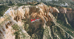
Bryce Canyon National Park (KBCE), Utah, Photo-Scenery (FS9 & FSX)
Despite its name, Bryce Canyon is not actually a canyon that was formed by a river, but rather a giant natural cliff shaped through erosion by wind, water, and ice. Bryce is distinctive due to its geological formations, delicate and colorful pinnacles called hoodoos that are up to 200ft high. The bizarre forms and red, orange and white colors of the rocks provide spectacular views. Unfortunately the hoodoos are too small for the elevation mesh in flight simulator. But you can enjoy the colors and shape of the cliffs. The cliffs in main region of the park, just south of the airport are partly covered
by snow. But on the southern and western part of the plateau you can enjoy them free of snow. Bryce Canyon is named after the Mormon pioneer Ebenezer Bryce who settled in this area in the 1850s. It was designated as a national park in 1928.
Bryce Canyon Airport (KBCE) just handles small aircraft on a daily basis. But is was actually built to handle larger aircraft in case of emergency. And so on Oct.6th 2000 an American Airlines MD-82 from Denver to Los Angeles made a successful emergency landing after reporting smoke in the cockpit and a loss of cabin pressure.
High resolution versions of this scenery for FS9 and FSX (much sharper, but larger and multiple downloads)are available at www.blueskyscenery.com/CNY_South2West4.html . The screenies are taken from the high-res versions, so expect this version to be slightly more blurry. Thanks to Joop Mak for providing a custom AFCADs that correct airport layouts so that they align with the photo-textures! They are available here: www.blueskyscenery.com/AFCADs.html . YourDonation@Work: Dedicated to Michael, Pat and Keith.
| Filename: | Bryce_Canyon_National_Park_KBCE_Utah_PhotoScenery.zip |
| License: | Freeware, limited distribution |
| Added: | 7th March 2010, 11:17:56 |
| Downloads: | 2,205 |
| Author: | Gottfried Razek, blueskyscenery.com |
| Size: | 96.35 MB |
| Category: Flight Simulator 2004 - Scenery | |
| VFR of Lario, Area A2 - Como lake, Italy |
|
Images related to this file:
File Description:
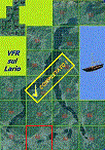
This is the seventeenth scenery, THE LAST ONE, of the "VFR of Lario" project.
This scenery covers approximately an area of 7.5x6 kmt, from the mountains over Albese con Cassano/Albavilla (NW) to Segrino small lake (NE), from Verzago/Alzate Brianza (SW) to Tabiago/Cibrone, Costa Masnaga (SE). Inside Verzago area is placed the AVL airport for gliders (LILB - Aeroclub Volovelistico Lariano).
Check video available here: http://youtu.be/r4h5PCVNMJM and https://youtu.be/huKdtYar_uQ
| Filename: | VFR_of_Lario_Area_A2__Como_lake_Italy.zip |
| License: | Freeware |
| Added: | 14th November 2013, 19:15:18 |
| Downloads: | 594 |
| Author: | Aldo Della Vedova, Daniele Lanfranchi, Gian Mario Verga |
| Size: | 16.66 MB |
| Category: Flight Simulator 2004 - Scenery | |
| Black Pond Airstrip - N46 |
|
Images related to this file:
File Description:
Welcome to Black Pond airstrip. This is an airstrip located in Farmers Mill, NY. It is a privately owned airstrip and it has a very mysterious history. Farmer's Mill is located east of KPOU and on the other side of the Hudson River east from KSWF near the Taconic state parkway. This is the first airport I have ever created. It includes one 3500' tarmac runway, 1000' grass strip, and a 4500' water runway. This was created for FS2004, but it might work with FSX. Happy flying!
| Filename: | Black_Pond_Airstrip__N46.zip |
| License: | Freeware |
| Added: | 11th October 2010, 00:02:03 |
| Downloads: | 273 |
| Author: | Sean Zottarelli |
| Size: | 87.5 KB |
| Category: Flight Simulator 2004 - Scenery | |
| Kerry EIKY Air Force Base - Home to the '509th' |
|
File Description:
Kerry AFB - Home of the '509th' Air Ranger Wing!
Irelands first fictional airbase. Uses default buildings but has a new extended runway, taxiways and parking. All military parking except designated Ryanair as they serve the airport daily. AFCAD File, Flight Plans and Pictures ONLY!
I have included flight plans betweem Kerry and Baldonnel AB. They are in the MRAI format so you will need to install there installer, www.mostrealisticai.com
I have not included aircraft as it is up to you what you want to fly!
| Filename: | Kerry_EIKY_Air_Force_Base__Home_to_the_509th.zip |
| License: | Freeware |
| Added: | 18th February 2004, 20:32:42 |
| Downloads: | 722 |
| Author: | René Bruun |
| Size: | 129.37 KB |
© 2001-2026 AVSIM Online
All Rights Reserved
Privacy Policy |