
Where Flight Simulation Enthusiasts Gather from Around the World!
AVSIM Library - Search Results

| Category: Flight Simulator 2004 - Scenery | |
| Morrisville-Stowe State, Vermont (KMVL) |

|
File Description:
FS204 Scenery-Morrisville-Stowe State Airport, Vt. (KMVL) serves Morrisville and Lamoille County and is owned by the State Of Vermont. The paved runway extends 3,701 feet. The facility is at an elevation of 732 feet and is about two miles from Morrisville. Scenery requires EZ Scenery and Rwy12 libraries,(Please read the readme file) AFCAD2, Traffic Tools and Nova texture sets. Lago's FSE is optional. By John B. Loney, Jr.
| Filename: | MorrisvilleStowe_State_Vermont_KMVL.zip |
| License: | Freeware |
| Added: | 21st May 2006, 18:51:01 |
| Downloads: | 717 |
| Author: | John B. Loney, Jr. |
| Size: | 938.42 KB |
| Category: Flight Simulator 2004 - Scenery | |
| Murfreesboro Municipal - KMBT |
|
Images related to this file:
File Description:
FS2004 Scenery-Murfreesboro Municipal Airport (KMBT) serves Murfreesboro and Rutherford County and is owned by the City Of Murfreesboro. The paved runway extends for 3898 feet. The facility is at an elevation of 615 feet at a distance of about 2 miles from Murfreesboro. Created entirely with EZ Scenery. EZ Scenery library objects required. New AFCAD file and AI traffic from Traffic Tools included. By John B. Loney, Jr.
| Filename: | Murfreesboro_Municipal__KMBT.zip |
| License: | Freeware, limited distribution |
| Added: | 3rd June 2010, 00:43:34 |
| Downloads: | 817 |
| Author: | John B. Loney, Jr. |
| Size: | 1.09 MB |
| Category: Flight Simulator 2004 - Scenery | |
| Cape May-Lewes Ferry |
|
File Description:
FS2004 Scenery - Cape May-Lewes Ferry. This scenery consists of the ferry terminal at Cape May, New Jersey and the ferry terminal at Lewes, Delaware. The AI ferry, M.V. Cape May sails from The Cape May Ferry Terminal, just south of the Cape May County Airport(KWWD), to the Lewes Ferry Terminal in Lewes Delaware. AI ferryboat included. Compatible with default FS9 and Ultimate Terrain. By John B. Loney, Jr.
| Filename: | Cape_MayLewes_Ferry.zip |
| License: | Freeware, limited distribution |
| Added: | 30th January 2008, 03:12:46 |
| Downloads: | 876 |
| Author: | John B. Loney, Jr. |
| Size: | 648.42 KB |
| Category: Flight Simulator 2004 - Scenery | |
| Optional 32-bit textures for my Harare and Victoria Falls sceneries. |
|
File Description:
This archive contains only the 32-bit format replacement textures for use with my sceneries for Harare and Victoria Falls that are also hosted on Avsim. This archive has been made separate because people using dial-up access shouldn't be forced to upload gargantuan texture files simply to enjoy a new airport or two. Note that the textures were worked on as 24-bit images and saved as 32-bit.
| Filename: | Optional_32bit_textures_for_my_Harare_and_Victoria.zip |
| License: | Freeware, limited distribution |
| Added: | 28th November 2005, 13:51:54 |
| Downloads: | 1,950 |
| Author: | Matthew Ministry |
| Size: | 8.95 MB |
| Category: Flight Simulator 2004 - Scenery | |
| Landing Areas for Western Australia V1 |
|
File Description:
A collection of 35 dirt station strips (ranch strips)and country airstrips for Western Australia made from a blend of AFCAD, Airport, Runway 12, E.O.D. and Google Earth and using my country api's. Some textures are mine and the rest are an accumulation of 6 years FS. An addition to the many other fine contributions for WA. Simply unzip in addon scenery and register the folder in your FS.
| Filename: | Landing_Areas_for_Western_Australia_V1.zip |
| License: | Freeware |
| Added: | 13th August 2006, 20:39:56 |
| Downloads: | 1,162 |
| Author: | Alan Blencowe |
| Size: | 5.03 MB |
| Category: Flight Simulator 2004 - Scenery | |
| Peggo Devon CPD7 |
|
Images related to this file:
File Description:
Tucked in the far NE corner of British Columbia, Peggo Devon is a 4200' gravel landing strip serving the Devon Corporation's natural gas mining facility there. The runway has night lighting and there is an NDB on the field, but there are no instrument landing procedures. The layout of the airport is accurately reproduced here, including a portion of the extensive surrounding network of roads and drilling sites.
| Filename: | Peggo_Devon_CPD7.zip |
| License: | Freeware |
| Added: | 25th June 2011, 06:27:50 |
| Downloads: | 279 |
| Author: | Sidney Schwartz & Peter Ham |
| Size: | 1.14 MB |
| Category: Flight Simulator 2004 - Scenery | |
| St. Maries S72 Idaho |
|
File Description:
St. Maries is a nice little general aviation airport located on the St. Joe River at the southern end of Coeur D' Alene Lake. VFR only, but there is a rotating beacon and runway lighting and night operations are allowed. The runway was moved to its correct location, the taxiways and aprons redone from scratch, and all buildings replaced. Also included is AI traffic that uses the default FS9 aircraft.
| Filename: | St_Maries_S72_Idaho.zip |
| License: | Freeware |
| Added: | 10th July 2008, 09:02:04 |
| Downloads: | 488 |
| Author: | Sidney Schwartz |
| Size: | 875.06 KB |
| Category: Flight Simulator 2004 - Scenery | |
| Red Wing Regional KRGK |
|
File Description:
FS2004 Scenery - Red Wing Municipal Airport (KRGK) serves Red Wing and Pierce County and is owned by the City Of Redwing. The paved runway extends for 4002 feet. The facility is at an elevation of 785 feet at a distance of about 3 miles from Red Wing. Red Wing is physically in Wisconsin, but is listed, with the FAA, in Minnesota, USA. Created with Instant Scenery by John b. Loney, Jr.
| Filename: | Red_Wing_Regional_KRGK.zip |
| License: | Freeware, limited distribution |
| Added: | 17th February 2009, 17:53:25 |
| Downloads: | 599 |
| Author: | John B. Loney, Jr. |
| Size: | 7.54 MB |
| Category: Flight Simulator 2004 - Scenery | |
| Franklin County State KFSO Scenery |
|
File Description:
Franklin County State Airport (KFSO), Vt. principally serves Highgate and is owned by the State Of Vermont. The paved runway extends 3,000 feet. The facility is at an elevation of 228 feet and is about three miles from Highgate. Download incorporates FSDS3, Rwy12, EZ Scenery and Lago's FSE. Also a new AFCAD2 file and AI Traffic via Traffic Tools. FSDS3 textures included. Rwy12 and EZ Scenery libraries required.
| Filename: | Franklin_County_State_KFSO_Scenery.zip |
| License: | Freeware |
| Added: | 14th May 2006, 21:40:56 |
| Downloads: | 751 |
| Author: | John B. Loney, Jr. |
| Size: | 822.9 KB |
| Category: Flight Simulator 2004 - Scenery | |
| Italy, Toscana 6, Firenze, Photo Real |
|
Images related to this file:
File Description:
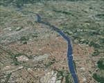
Toscana, Italy, Photoreal Scenery Part 6 (Firenze).
The photoreal scenery covers a great area of Toscana (Tuscany) around the city of Firenze (Florence). The airport of Firenze Peretola (LIRQ) are found inside the scenery (see map). For the best results, use it in association with other parts of Toscana photoreal: Toscana 1 Grosseto, Toscana 2 Piombino, Toscana 3 Siena, Toscana 4 Poggibonsi, Toscana 5 Livorno_Lucca_Pisa_Pistoia, Toscana 7 Massa_Carrara, italy_islands_vfr_part2_nw.zip
| Filename: | Italy_Toscana_6_Firenze_Photo_Real.zip |
| License: | Freeware |
| Added: | 28th April 2010, 13:46:09 |
| Downloads: | 7,053 |
| Author: | Fulvio Mazzokan |
| Size: | 89.82 MB |
© 2001-2026 AVSIM Online
All Rights Reserved
Privacy Policy |