
Where Flight Simulation Enthusiasts Gather from Around the World!
AVSIM Library - Search Results

| Category: Flight Simulator 2004 - Scenery | |
| Airstrips of Eastern France |

|
Images related to this file:
File Description:
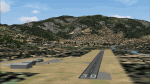
Next in my ongoing "Airstrips of Western Europe" project for FS2004, herewith about 100 sceneries of small, mostly default airfields in the eastern section of France, each enhanced with taxiways, parking spaces and aprons as appropriate, to further facilitate the generation of lightweight AI traffic in the area without overloading the more major airfields. When combined with the French airstrips from my previous uploads, the majority of the default small French airstrips in FS2004 will be able to generate AI traffic, should you so wish, as well as putting a little basic detail into the countryside.
Again, there's no photo-realism here, just a selection of basic 'generic' buildings, more or less accurately sized and placed to reflect the airfield layout as seen on on-line satellite imagery and aerial photography. These buildings have minimal effect on frame-rates, so are ideal for this kind of job. The airfields are aligned as well as possible with the roads etc. in UT Europe and the Genesis Europe mesh, but should mostly be fine in a default installation or other configuration.
| Filename: | Airstrips_of_Eastern_France.zip |
| License: | Freeware |
| Added: | 25th September 2024, 13:37:50 |
| Downloads: | 148 |
| Author: | Chris Eve |
| Size: | 2.83 MB |
| Category: Flight Simulator 2004 - Scenery | |
| Backcountry airfields for 19m terrain mesh in Idaho USA |
|
Images related to this file:
File Description:
These four backcountry fields are for use with the FSGenesis 19m mesh of Idaho, and are Big Creek, Johnson Creek, Dixie, and Sulphur Creek Ranch. They have been revised to fit and almost certainly do not work without the 19m mesh; a quick comparison with Big Creek before and after demonstrates the difference. I also have Ultimate Terrain installed. The three ingredients of terrain mesh, UT main roads, and UT streams, along with their individual margins of error, very often create conficts of space that make a grass runway impossible to site with it's correct length. Given the choice of turning off roads or streams (the terrain mesh cannot be turned off, obviously) I chose streams; the roads are less obviously incorrect, plus it matters not if roads go uphill while a climbing stream is to be avoided. On that basis the original series is reissued here for use with the 19m terrain mesh, on the presumption that you have already downloaded the original series. There are no textures or AI included as they remain the same as the originals, and the new scenery bgl's replace the originals to get the runways and grass etc in the right positions. There will be follow-on fields that are new, and all of the new ones will be only for the 19m mesh.
| Filename: | Backcountry_airfields_for_19m_terrain_mesh_in_Idah.zip |
| License: | Freeware, limited distribution |
| Added: | 29th May 2017, 04:19:43 |
| Downloads: | 124 |
| Author: | Roger Wensley |
| Size: | 2.22 MB |
| Category: Flight Simulator 2004 - Scenery | |
| Tinian 1945 |
|
Images related to this file:
File Description:
Tinian and the Marianas Island as they (nearly) were in 1945. It includes 8 detailed airfields, with traffic AI (you will need to download original aircraft) : Tinian, Saipan, Rota (fictionous place for the famous VMF-214 Black Sheeps squadron of Greg "Papy" Boyington), Guam. Read carefully the instructions.
| Filename: | Tinian_1945.zip |
| License: | Freeware |
| Added: | 3rd February 2010, 02:16:05 |
| Downloads: | 638 |
| Author: | Daniel Gauthier |
| Size: | 40.46 MB |
| Category: Flight Simulator 2004 - Scenery | |
| RAF Blyton |
|
File Description:
RAF Blyton in North Lincolnshire. This is the second airfield in my attempt to render all of Group 1 RAF Bomber Command's airfields. I am awaiting site plans from the RAF Museum to check this site but I'm hoping I've got it right. As always---talk to me
| Filename: | RAF_Blyton.zip |
| License: | Freeware |
| Added: | 17th November 2006, 23:30:43 |
| Downloads: | 1,171 |
| Author: | Justin Hulme |
| Size: | 2.12 MB |
| Category: Flight Simulator 2004 - Scenery | |
| Yemen Airports v1.0 |
|
Images related to this file:
File Description:
A simple scenery for more than ten airports in Yemen including some gravel airfields. All airports have been updated and modified as per the latest charts \ images available, also the ATC services and navaids now available in Socotra Airport. More details and information about the airports inside the pack.
| Filename: | Yemen_Airports_v10.zip |
| License: | Freeware |
| Added: | 25th January 2014, 12:10:09 |
| Downloads: | 1,078 |
| Author: | Nuhaid Abdulkhaleq |
| Size: | 53.66 MB |
| Category: Flight Simulator 2004 - Scenery | |
| Redcliffe & Caboolture Airports, Queensland |
|
File Description:
THese are my latest versions of these two great little General Aviation airports for FS9 (FS2004)
Redcliffe is the next biggest general aviation airport in the Brisbane region after Archerfield.This version is a fairly close representation of the real thing which is the home of 2 flying schools. Many ga and also sport aircraft are hangered here. Watch out for the swamp at either end of the runway.... quite a few aircraft over the years have landed there by accident! Redcliffe is also notorious for crosswinds which can make takeoffs and landings interesting at this airport.Caboolture is a wonderful little grass strip about 10 minutes flying north of Redcliffe. The airstrip dates back to WWII and is the home of a strong warbird/vintage aircraft restoration industry, 3 flying schools, a glider club and also a large ultralight fraternity. Caboolture can be a busy little airport on the weekends and a Vintage GA aircraft spotters paradise!
| Filename: | Redcliffe__Caboolture_Airports_Queensland.zip |
| License: | Freeware |
| Added: | 24th September 2003, 00:56:27 |
| Downloads: | 1,429 |
| Author: | Steve James, Mal Lloyd |
| Size: | 2.74 MB |
| Category: Flight Simulator 2004 - Scenery | |
| London City Airport (EGLC), UK - "Masterplan Concept" Version 2 |
|
Images related to this file:
File Description:

The masterplan for London City has been around for a while so we have developed a concept to reflect it. This airport is compatible with the default traffic file, and handles added traffic well. This concepts adds a full parallel taxiway, extra parking and more high speed exits to the runway to handle more traffic.
New in V2 extra parking for GA and small jets, "RWY AHEAD" markings on the taxiways and parking area markings.
| Filename: | London_City_Airport_EGLC_UK__Masterplan_Concept_Ve.zip |
| License: | Freeware, limited distribution |
| Added: | 28th September 2013, 12:33:53 |
| Downloads: | 588 |
| Author: | Mark Piccolo - Soarfly Concepts |
| Size: | 894.96 KB |
| Category: Flight Simulator 2004 - Scenery | |
| Rivière-du-Loup |
|
File Description:
Rivière-du-Loup is an important locality situated about 85nm downstream of Québec City on the South shore of the St.Lawrence River. Québec Short Hops includes installations aimed at making VFR flying in Québec most interesting. Many items and candies are also added around the airfields and where possible, between sceneries.
| Filename: | RivireduLoup.zip |
| License: | Freeware |
| Added: | 15th November 2003, 12:12:59 |
| Downloads: | 2,387 |
| Author: | Léon Louis |
| Size: | 4.79 MB |
| Category: Flight Simulator 2004 - Scenery | |
| Norfolk Trees pt1 |
|
File Description:
This zip will place trees into the scenery for Norfolk UK for FS9. It is designed to be compliant with VFR Photographic Scenery, VFR Terrain part 1 and the UK2000 scenery. Also included are af2 files for Hethel (EGSK) and Felthorpe, and files to place trees close to UK2000 airfields.
| Filename: | Norfolk_Trees_pt1.zip |
| License: | Freeware, limited distribution |
| Added: | 26th May 2010, 00:45:32 |
| Downloads: | 349 |
| Author: | Norman Dean |
| Size: | 325.57 KB |
| Category: Flight Simulator 2004 - Scenery | |
| Isle of Wight and Solent |
|
File Description:
Isle of Wight and Solent Scenery Package.
Includes detailed landmarks, 3 detailed airfields (Sandown, Bembridge, Lee-on-Solent), dynamic scenery (Ferry, Catamaran, Hovercraft and Hampshire Police Aircraft), replacement coastlines, Ai traffic, and road system.
Also included is a document detailing some of the aviation and maritime history of the area.
| Filename: | Isle_of_Wight_and_Solent.zip |
| License: | Freeware, limited distribution |
| Added: | 5th January 2006, 03:16:50 |
| Downloads: | 7,406 |
| Author: | David Glaister |
| Size: | 6.38 MB |
© 2001-2026 AVSIM Online
All Rights Reserved
Privacy Policy |