
Where Flight Simulation Enthusiasts Gather from Around the World!
AVSIM Library - Search Results

| Category: Flight Simulator 2004 - Scenery | |
| Airstrips of South-West France |

|
File Description:
Part two of my "Airstrips of Western Europe" project, these 90+ sceneries are mostly default basic airstrips from FS2004, enhanced with taxiways, parking spaces and aprons as appropriate, to facilitate the activation of lightweight GA AI traffic, primarily over the south-west of France. Hopefully these will allow a degree of continuity between my previous upload (Airstrips of North-West Europe) and the existing freeware releases for Spain and Portugal.
Again, there's no photo-realism here, just a selection of basic 'generic' buildings, more or less accurately sized and placed to reflect the airfield layout as seen on on-line satellite imagery and aerial photography. These buildings have minimal effect on frame-rates, so are ideal for this kind of job. The airfields are aligned as well as possible with the roads etc. in UT Europe and the Genesis Europe mesh, but should mostly be fine in a default installation or other configuration.
A good number of airfields in this area have been neatly implemented in the "Occitania_VFR" package, so I've not duplicated their work.
Also included are some "bonus" sceneries from further north that weren't included in my previous upload. Just copy them over as appropriate if required.
| Filename: | Airstrips_of_SouthWest_France.zip |
| License: | Freeware |
| Added: | 16th July 2024, 18:20:44 |
| Downloads: | 111 |
| Author: | Chris Eve |
| Size: | 274.73 KB |
| Category: Flight Simulator 2004 - Scenery | |
| Airstrips of Switzerland |
|
Images related to this file:
File Description:

Just a small collection of of ai-enabled airfields, that don't appear to have been implemented by other authors, to further expand my Airstrips of Europe project.
Again, there's no photo-realism here, just a selection of basic 'generic' buildings, more or less accurately sized and placed to reflect the airfield layout as seen on on-line satellite imagery and aerial photography. These buildings have minimal effect on frame-rates, so are ideal for this kind of job. The airfields are aligned as well as possible with the roads etc. in UT Europe and the Genesis Europe mesh, but should mostly be fine in a default installation or other configuration. As before, the files for each airfield can be easily identified by the ICAO code, even if the airfield names vary slightly, so you can pick and choose and mix and match to suit any sceneries you already have, should you so wish. There is no requirement for any other download. Each airfield will exist as a stand-alone entity should you only want a few of them. Please read the rest of this "blurb" in the included text file. There may be some details of note or interest.
| Filename: | Airstrips_of_Switzerland.zip |
| License: | Freeware |
| Added: | 6th March 2025, 21:00:04 |
| Downloads: | 113 |
| Author: | Chris Eve |
| Size: | 437.07 KB |
| Category: Flight Simulator 2004 - Scenery | |
| Wrigley CYWY - Northwest Territories, Canada |
|
Images related to this file:
File Description:
Wrigley is the next in a series of airfields that follow (approximately) in a southward direction that early access route to the Canadian northern shore, the Mackenzie River. At the far northern end there is Tuktoyaktuk, then Inuvik, Fort McPherson, Fort Good Hope, and Deline, all posted. Wrigley is at 489 feet asl and on the east bank of the the Mackenzie, around 135 miles due south of Deline. The town of Wrigley has a population of only 125 or so folks, and was relocated to its current position in 1965 from Fort Wrigley to be near the WW2 era airfield; I have no idea where Fort Wrigley is, or was. The airport is just over a mile south of the town, and has 3,500 feet of gravel runway. North Wright Air have scheduled flights to here and other airfields up and down the Mackenzie (including Deline, Fort Simpson, and Fort Good Hope etc) which is reflected in the revised AI. There is again a mandatory radio frequency but I have set the "tower" as unmanned so you will announce intentions and join downwind. There is no fuel available.
| Filename: | Wrigley_CYWY__Northwest_Territories_Canada.zip |
| License: | Freeware, limited distribution |
| Added: | 5th July 2014, 21:01:37 |
| Downloads: | 211 |
| Author: | Roger Wensley |
| Size: | 3.81 MB |
| Category: Flight Simulator 2004 - Scenery | |
| Chilko Lake CAG3 & Scum Lake CAW3 in British Columbia Canada |
|
Images related to this file:
File Description:
Chilko Lake and Scum Lake are both on the eastern side of the Coast Mountains of British Columbia. Chilko Lake CAG3 is around 30 miles south of Puntzi Mountain and at the northern end of the lake, serving Tsylos Park Lodge, which caters for trekking, horse riding, mountain biking, fishing etc. The runway is 3,200 feet of gravel aligned 18-36 and unlit, at 3,850 feet ASL (above sea level). Scum Lake is around 30 miles southeast of Puntzi Mountain and 25 miles northeast of Chilko Lake. Don't ask me about the name. The airstrip appears to serve a small village and is noted as "private", so perhaps also a lodge operation. The runway is 3,500 feet of gravel aligned 03-21, unlit and at 3,921 feet ASL. I have posted these as a separate scenery, but I suggest that you just add it to your previously created "BC airfields" and avoid the inevitable doubling up of common textures etc. Plus that way you will have just one FS9 library post to do and new airfields will not need yet another posting. Up to you. If you find a defect, email me.
| Filename: | Chilko_Lake_CAG3__Scum_Lake_CAW3_in_British_Columb.zip |
| License: | Freeware, limited distribution |
| Added: | 21st November 2020, 18:24:29 |
| Downloads: | 114 |
| Author: | Roger Wensley |
| Size: | 11.85 MB |
| Category: Flight Simulator 2004 - Scenery | |
| Fordlandia - Ford Rubber Factory - Brazil |
|
Images related to this file:
File Description:
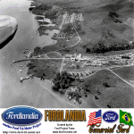
FS2004 Scenery Fordlandia
Fordlandia is a now-abandoned, prefabricated industrial town established in the Amazon Rainforest in 1928 by American industrialist Henry Ford to secure a source of cultivated rubber for the automobile manufacturing operations of the Ford Motor Company in the United States.
Scenery is a historical FS2004 rendition of the town and factory facilities circa 1930's. Has a runway and airport plus a sea runway and some additional fictional extras to enrich the scenery. Created for your flight sim enjoyment by the Ford Project Team. This FREE scenery and many more can be found at: http://www.ford-tri-motor.net/scenery.htm Plus buckets of historical liveries available for several vintage aircraft at the Ford Project Site.
| Filename: | Fordlandia__Ford_Rubber_Factory__Brazil.zip |
| License: | Freeware, limited distribution |
| Added: | 19th October 2013, 10:46:45 |
| Downloads: | 248 |
| Author: | Garry J. Smith and Edward C. Moore |
| Size: | 6.16 MB |
| Category: Flight Simulator 2004 - Scenery | |
| Bluff Park Farm 71AK, Wasilla Creek Airpark 05AK, Memory Lake 5AK8, 3AK2, 05AK, 5AK5, 16AK, 34AK, 59AK, and AK65, all near Anchorage in Alaska, PART 2 Flattens |
|
Images related to this file:
File Description:
Bluff Park Farm 71AK, plus Wasilla Creek Airpark 05AK, plus Memory Lake 5AK8, plus 3AK2, 05AK, 5AK5, 16AK, 34AK, 59AK, and AK65, all near Anchorage in Alaska, US FLATTENS PART 2
This is a PART 2 repost from 100 years ago because only one down-loader informed me very very recently that three airfields in that area needed altitude adjustment, namely 5AK8, 05AK, and 71AK. If you have this problem put the three bgl's in the FS9/Scenery/World/Scenery folder. If you don't have this problem then ignore this and finish your beer.
| Filename: | Bluff_Park_Farm_71AK_Wasilla_Creek_Airpark_05AK_Me.zip |
| License: | Freeware, limited distribution |
| Added: | 29th November 2019, 22:41:51 |
| Downloads: | 111 |
| Author: | Roger Wensley |
| Size: | 4.2 KB |
| Category: Flight Simulator 2004 - Scenery | |
| Alexandria CNS4 field near Ottawa, Ontario, Canada |
|
Images related to this file:
File Description:
This was the thirteenth of a projected 16 airfields in the Ottawa area originally posted in 2006; this version has specifically modeled buildings. Alexandria is just a mile east of the town of the same name, 50 miles east of Ottawa International and 16 miles north of Cornwall. It has one grass runway which is 2,020' long and 100' wide and which parallels the road. There are two hangers and a two storey clubhouse, and fuel. And in the summer look out for the gliders doing right hand circuits and the parachutists on vertical finals.
| Filename: | Alexandria_CNS4_field_near_Ottawa_Ontario_Canada.zip |
| License: | Freeware, limited distribution |
| Added: | 16th February 2010, 01:41:39 |
| Downloads: | 440 |
| Author: | Roger Wensley |
| Size: | 1.33 MB |
| Category: Flight Simulator 2004 - Scenery | |
| Edinburgh Island, FOX-2, Horton River, Igloolik, & Kimmirut, adapted for the FSGenesis 76m North Canada Terrain Mesh |
|
Images related to this file:
File Description:
These are replacement bgl's to convert five northern Canada fields for use with the FSGenesis 76m terrain mesh for northern Canada. The five are Edinburgh Island CWEI, the FOX-2 DEW line station, Horton River CWHR, Igloolik CYGT, and Kimmirut CYLC. These are not stand-alone, and the presumption is that you have already downloaded and installed the previously posted sceneries. This installation consists solely of replacing the existing scenery bgl's with the new. There will be further posts of northern airfields in groups of five, alphabetically, and observations regarding the amendments and any further corrections that are required would be welcomed.
| Filename: | Edinburgh_Island_FOX2_Horton_River_Igloolik__Kimmi.zip |
| License: | Freeware, limited distribution |
| Added: | 10th September 2017, 19:29:57 |
| Downloads: | 86 |
| Author: | Roger Wensley |
| Size: | 3.55 MB |
| Category: Flight Simulator 2004 - Scenery | |
| EDXN+ETMN Nordholz-Spieka Airfield and Nordholz Navy Airbase |
|
Images related to this file:
File Description:
Because so many of you asked, I reworked my former Nordholz Navy Airbase Scenery.
This is the new Nordholz-Spieka (EDXN) Scenery with the moved Runway while the Navy expand its area.
The Scenery part with the Nordholz Navy Airbase is totaly reworked. All Hangars are now like the real ones, taxi signs have been placed, ground textures are placed around the airfields and as a special gift to you, I added a small traffic pack to this package.
It contains the traffic for the Brequet Atlantic and Helicopters at Northwood Airbase. Enjoy it!
| Filename: | EDXNETMN_NordholzSpieka_Airfield_and_Nordholz_Navy.zip |
| License: | Freeware |
| Added: | 9th July 2014, 17:07:24 |
| Downloads: | 1,065 |
| Author: | David Kolas |
| Size: | 14.13 MB |
| Category: Flight Simulator 2004 - Scenery | |
| Green Ground Service Vehicle Library |
|
Images related to this file:
File Description:
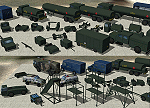
Inspired by the superior work of Michael Carr I have developed a small library of Ground Service Equipment. These objects are mostly painted in the standard olive drab you find at many military airfields. As with all my work the emphasis is on Frame-Rates and not microscopic reality so squint a little and pretend. As some of these objects have been included in my earlier scenery releases, as well as used by other designers, the GUIDs are the same and your existing scenery should not be affected. This will the final version/release of this library. PLEASE READ THE INSTALLATION NOTES CAREFULLY
| Filename: | Green_Ground_Service_Vehicle_Library.zip |
| License: | Freeware, limited distribution |
| Added: | 27th April 2014, 05:34:06 |
| Downloads: | 6,804 |
| Author: | John Stinstrom |
| Size: | 1.05 MB |
© 2001-2026 AVSIM Online
All Rights Reserved
Privacy Policy |