
Where Flight Simulation Enthusiasts Gather from Around the World!
AVSIM Library - Search Results

| Category: Flight Simulator 2004 - Scenery | |
| Legnano scenery - Italy |

|
Images related to this file:
File Description:
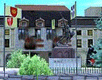
Homage to my town, scenery built mainly with existing objects, buildings by sintax and few experiments by GMax. It DOES NOT include any airport, but represents some pictures of Legnano town
Informations: Legnano is a town in north of Italy (approx 25 kmt NW Milan, ref coordinates N45 35.98 E8 54.59), reachable from Casorezzo ultralight airport (closest one) or all the near others of Milan area.
Here was done in 1176 the historical fight of the Alliance Lombarda's city-states against Federico Barbarossa German imperator. Legnano is also well known for his metallurgical and textile industries story.
Contents: rev.1 : down town square with municipal Palazzo Malinverni and S. Magno basilica, skyscraper, one of Olona river's bridges, G. Mari football stadium, Alberto da Giussano circus with related monument, encircled by the eight quarter's flags, F. Tosi and Manifattura industrial buildings, Rail station, external parking and glass building
rev.2 : Courthouse building with Teresa's face bronze statue and some more buidings, Palio hystorical figurants inside the stadium, Carroccio and Alberto da Giussano rider, Small goods train on railroad; S. Magno belltower reviewed, red sky-lights on top of skyscraper and chimney, Chimney smoke
| Filename: | Legnano_scenery__Italy.zip |
| License: | Freeware |
| Added: | 27th March 2011, 02:55:40 |
| Downloads: | 649 |
| Author: | Aldo Della Vedova |
| Size: | 6.83 MB |
| Category: Flight Simulator 2004 - Scenery | |
| EGVL - RAF Little Rissington - Gloucestershire, England |
|
Images related to this file:
File Description:

Representative scenery of RAF Little Rissington in Gloucestershire.
RAF Little Rissington (ICAO: EGVL) is an RAF aerodrome and former RAF station in Gloucestershire, England. It was once home to the Central Flying School, the Vintage Pair and the Red Arrows.
Built during the 1930s, the station was opened in 1938 and closed in 1994. The married-quarters and main technical site were sold in 1996 (the former becoming the village of Upper Rissington), but the aerodrome has been retained by the Ministry of Defence and remains active along with the southern technical sites, under the operational control of No.2 Flying Training School at RAFC Cranwell.
It is now home to 637 Volunteer Gliding Squadron as the primary military unit, who provide elementary flying training for Combined Cadet Force and Air Training Corps cadets. The airfield is also used by the forces as a relief landing ground, training area and parachute dropping area. In previous years, the Royal Air Force estate has been used as a film set, including The Avengers, part of the ice chase in Die Another Day, and the Thunderbirds film.
This scenery has been made using various scenery libraries, mainly from MAIW. Full listing in the docs.
| Filename: | EGVL__RAF_Little_Rissington__Gloucestershire_Engla.zip |
| License: | Freeware, limited distribution |
| Added: | 28th July 2014, 09:17:31 |
| Downloads: | 1,063 |
| Author: | Brian Clarke, Daryl Payne, Stewart Pearson |
| Size: | 448.92 KB |
| Category: Flight Simulator 2004 - Scenery | |
| CYQU - Grande Prairie, Alberta, Canada |
|
Images related to this file:
File Description:
Grande Prairie is at 2,195 feet asl, 65 miles southeast of Dawsons Creek, 90 miles southwest of Peace River and around 60 miles east of the Rockies. The town has a population of 55,000 and growing. The airport is just to the west of the town and was originally a military base, built during WW2. The two runways are 07-25 and 11-29 and when one is the active runway then the other is used as a taxiway. AI in FS9 doesn't like this, and just stops at the first hold short without ever reaching the active runway. I have found a way to overcome this and AI will now use taxiway A and whichever runway is inactive to feed to and from both ends of the active runway. The vertical red tanks are for de-icing fluid; de-icing is carried out before take-off in the winter. The industrial area to the southeast is now larger than I have made it, but I kept it to this minimum size to keep frame rates down. All the buildings are modeled specifically for CYQU. The AI includes Westjet, Air Canada Jazz, and others as listed. The GA AI uses only FS9 standard aircraft.
| Filename: | CYQU__Grande_Prairie_Alberta_Canada.zip |
| License: | Freeware, limited distribution |
| Added: | 9th May 2014, 10:05:40 |
| Downloads: | 673 |
| Author: | Roger Wensley |
| Size: | 18.33 MB |
| Category: Flight Simulator 2004 - Scenery | |
| Cedar Lake Logging Camp |
|
File Description:
After flying my first real life solo flight I decided to celebrate by making a fun scenery for flightsim. Cedar Lake Logging Camp was designed to be a great destination for Northern Ontario (Canada) Bush pilots. It is situated northwest of Dryden. It has one 1800 foot gravel runway with trees on both sides for challenging approaches and takeoffs, a helipad and a dock for float operations (visible). There are several cabins on site as well as a hanger and fuel station on the gravel apron. There is a fuel barge and cargo crates by the float docks. For the bush atmosphere there are several deer in the area, a tractor pulling a mower by the runway, and two static aircraft (a Piper Cub by the hanger and a Cessna 185 on floats at the fuel barge). An AI aircraft is integrated into the file as well - the piper cub flies to Red Lake in the morning and to Dryden in the afternoon. There is also an integrated AFCAD file so the camp will show up in the flight simulator database and in the GPS. There are 5 starting locations including the runway ends, 2 parking spots on the apron, the helipad, and beside the dock. I hope you enjoy this as much as I will.
| Filename: | Cedar_Lake_Logging_Camp.zip |
| License: | Freeware, limited distribution |
| Added: | 19th February 2004, 01:33:22 |
| Downloads: | 2,121 |
| Author: | David Voogd |
| Size: | 2.69 MB |
| Category: Flight Simulator 2004 - Scenery | |
| Abruzzo Gran Sasso Italy |
|
File Description:
Abruzzo & Molise, Italy, Photoreal Scenery (26 june 2007).
Freeware scenery for FS2004. Author: Angelo Lanzillotta
This photoreal scenery is based on aerial photos grabbed at the resolution of 5 meters per pixel (the same used in FS2004). I worked hardly on these photos to obtain a final product with the real colours and the real positions for all parts of the landscape: if you have any comments or suggests, feel free to email me.
Every single part of this scenery can be used also as a standalone product, so it's not necessary to download all 4 parts of my big scenery.
However i strongly suggest to use all parts in order to obtain a complete photoreal look of this beautiful italian landscape, with famous mountains like Gran Sasso and Maiella.
For best results, use this scenery in association with Pietro Mauri Italymesh2004.
DISCLAIMER
This scenery is released as freeware, so nobody can make money with it.
You cannot include this scenery in any software collection or web site without written permission of author.
You can add objects and autogen (i had no time to work on them).
This software can be used only as FSX/FS2004/FS2002 scenery: no other use is allowed.
I accept absolutely no responsibility for your use of this software.
Re uploaded in oct. 2012 by Roberto
| Filename: | Abruzzo_Gran_Sasso_Italy.zip |
| License: | Freeware |
| Added: | 4th October 2012, 17:08:09 |
| Downloads: | 1,177 |
| Author: | Angelo Lanzillotta |
| Size: | 72.13 MB |
| Category: Flight Simulator 2004 - Scenery | |
| Zion National Park North, Cedar Breaks National Monument, Cedar City (KCDC), Utah, Photo-Scenery (FS9 & FSX) |
|
Images related to this file:
File Description:
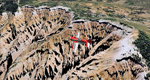
Cedar Breaks National Monument is a large amphitheater cliff in bright colors of red, orange and purple.
It lies east of Cedar City in the northern region of the scenery. The cliff was formed by erosion thru wind,
water and ice. Today erosion continues with a pace of about 2 inches every 5 years. Although it is called
Cedar Breaks, there are no cedars growing there but juniper trees. For a scenic flight to Cedar Breaks
National Monument best depart from Cedar City Regional Airport (KCDC) and head east. The scenery extends
south to Zion National Park and covers a large part of Zion Canyon and the Kolob Canyons area.
Zion National Park is another place where erosion of the Colorado Plateau formed the most beautiful colorful
stone formations of unique and wonderful shapes. There are nine different layers of stone visible in the park.
Most of them consist of sandstone. But there is also limestone, gypsum, siltstone, shale, clay and mudstone.
The Virgin River cut a spectacular and famous canyon thru Zion Park that is as narrow as 20ft and up to 2000ft tall.
High resolution versions of this scenery for FS9 and FSX (much sharper, but larger and multiple downloads)
are available at www.blueskyscenery.com/CNY_South2West5.html . The screenies are taken from the high-res versions,
so expect this version to be slightly more blurry.
Thanks to Joop Mak for providing a custom AFCADs that correct airport layouts so that they align with the photo-textures!
They are available here: www.blueskyscenery.com/AFCADs.html . YourDonation@Work: Dedicated to Richard, P.J. and Felix.
| Filename: | Zion_National_Park_North_Cedar_Breaks_National_Mon.zip |
| License: | Freeware, limited distribution |
| Added: | 14th March 2010, 00:30:28 |
| Downloads: | 1,566 |
| Author: | Gottfried Razek - blueskyscenery.com |
| Size: | 97.13 MB |
| Category: Flight Simulator 2004 - Scenery | |
| Abruzzo Campobasso Italy |
|
File Description:
Abruzzo & Molise, Italy, Photoreal Scenery (26 june 2007).
Freeware scenery for FS2004. All files of my scenery ABRUZZO & MOLISE; Author: Angelo Lanzillotta
This photoreal scenery is based on aerial photos grabbed at the resolution of 5 meters per pixel (the same used in FS2004). I worked hardly on these photos to obtain a final product with the real colours and the real positions for all parts of the landscape: if you have any comments or suggests, feel free to email me.
Every single part of this scenery can be used also as a standalone product, so it's not necessary to download all 4 parts of my big scenery.
However i strongly suggest to use all parts in order to obtain a complete photoreal look of this beautiful italian landscape, with famous mountains like Gran Sasso and Maiella.
For best results, use this scenery in association with Pietro Mauri Italymesh2004.
DISCLAIMER
This scenery is released as freeware, so nobody can make money with it.
You cannot include this scenery in any software collection or web site without written permission of author.
You can add objects and autogen (i had no time to work on them).
This software can be used only as FSX/FS2004/FS2002 scenery: no other use is allowed.
I accept absolutely no responsibility for your use of this software.
This scenery was re-uploaded in september 2012 by me, after it was lost after a hacker attack to AVSIM during 2009 - Roberto
| Filename: | Abruzzo_Campobasso_Italy.zip |
| License: | Freeware |
| Added: | 10th September 2012, 22:10:56 |
| Downloads: | 1,372 |
| Author: | Angelo Lanzillotta |
| Size: | 91.38 MB |
| Category: Flight Simulator 2004 - Scenery | |
| Abruzzo Pescara Italy |
|
File Description:
Abruzzo & Molise, Italy, Photoreal Scenery (26 june 2007).
Freeware scenery for FS2004.
All files of my scenery ABRUZZO & MOLISE; Author: Angelo Lanzillotta
This photoreal scenery is based on aerial photos grabbed at the resolution of 5 meters per pixel (the same used in FS2004- works in FS 2002 too). I worked
hardly on these photos to obtain a final product with the real colours and the real positions for all parts of the landscape: if you have any comments or
suggests, feel free to email me.
Every single part of this scenery can be used also as a standalone product, so it's not necessary to download all 4 parts of my big scenery.
However i strongly suggest to use all parts in order to obtain a complete photoreal look of this beautiful italian landscape, with famous mountains like Gran Sasso and Maiella.
For best results, use this scenery in association with Pietro Mauri Italymesh2004.
DISCLAIMER
This scenery is released as freeware, so nobody can make money with it.
You cannot include this scenery in any software collection or web site without written permission of author.
You can add objects and autogen (i had no time to work on them).
This software can be used only as FSX/FS2004/FS2002 scenery: no other use is allowed.
I accept absolutely no responsibility for your use of this software.
This flie was re-uploaded by me in September 2012, after it was lost because of an haker attack to AVSIM during 2009 - Roberto
| Filename: | Abruzzo_Pescara_Italy.zip |
| License: | Freeware |
| Added: | 10th September 2012, 22:17:13 |
| Downloads: | 1,412 |
| Author: | Angelo Lanzillotta |
| Size: | 94.96 MB |
| Category: Flight Simulator 2004 - Scenery | |
| Thompson CYTH in northern Manitoba, Canada |
|
Images related to this file:
File Description:
Thompson is a city with around 13,000 inhabitants, located in northern Manitoba beside the Burntwood River. It serves as the administration centre for a large area of Manitoba and has industrial activities centred around mining and the processing of mined products. The version of the airport upon which this modification is based is the original posting in 2004 by CanUK Scenery. I would have made new buildings and a totally new scenery but I have the same problem as Sid and Pete in their later Thompson scenery: almost no photos!?! The update modifies the short end of the mainly gravel runway to asphalt (it was upgraded because it is regularly used as a taxiway) and also adds a later (2010?) gravel taxiway. The other ground modifications add allocated parking spots for fire fighting CL415 planes that are in the new AI, plus a lot more ga parking. You should already have some AI that includes Calm Air to see CYTH as it really is, the HQ of Calm Air. There are other additions including car parks and the usual sundry bits and pieces that inhabit every airfield. The CL415's with Manitoba textures are adaptations of what were originally Ontario planes and included with my post of Geraldton, not the most recent post in 2013, the one in 2007. If you don't have the planes get them from my Geraldton post. The AI version was made from the original piloted version which was by Massimo Taccoli. The AI helicopter was included in my post of Alma CYTF.
| Filename: | Thompson_CYTH_in_northern_Manitoba_Canada.zip |
| License: | Freeware, limited distribution |
| Added: | 23rd September 2018, 15:24:22 |
| Downloads: | 225 |
| Author: | Roger Wensley |
| Size: | 6.4 MB |
| Category: Flight Simulator 2004 - Scenery | |
| Galena PAKP in Alaska |
|
Images related to this file:
File Description:
Galena is a village on the Yukon River, around 30 miles east of the corner where the westward running river turns south. The population is just under 500 and the city is noted for its educational facilities that attract residential students from across the state. Adjacent to the city is the Galena Air Force Station that previously shared the use of the Edward G. Pitna Snr. airport until 2007, when the station was closed and the air force personnel left. The station facilities have been taken over by the community and the airport became the largest state-maintained airport in the interior of Alaska. Substantial resurfacing and finishing work was then carried out, and the new asphalt runway is now 6,000 feet long and aligned 7-25, with VASI at both ends and ILS on 25. There is a secondary gravel runway beside part of the main asphalt runway, and this is treated in radio announcements as if it is not a separate runway and landing or take off are on the adjacent asphalt. The airport is serviced by ERA (now called Ravn) and Wrights Air, with cargo flights by the eternal Everts. Included here is a small modification for Allakaket, which deletes a single remaining stock FS9 taxiway light. The AI included here also provided Allakaket with a Saturday Everts delivery flight, but I neglected to mention that before. A note here about my scenery making. There will not be many more to follow this as I am almost at the end of the photos I either took or found for scenery purposes, plus I expect to move on from FS9 at some point during next year.
| Filename: | Galena_PAKP_in_Alaska.zip |
| License: | Freeware, limited distribution |
| Added: | 27th November 2019, 19:14:00 |
| Downloads: | 261 |
| Author: | Roger Wensley |
| Size: | 13.95 MB |


© 2001-2026 AVSIM Online
All Rights Reserved
Privacy Policy |