
Where Flight Simulation Enthusiasts Gather from Around the World!
AVSIM Library - Search Results

| Category: Flight Simulator 2004 - Scenery | |
| LJLJ - Ljubljana Airport - Slovenia (SLOLJLJ9.1.a) ** FIX ** |

|
Images related to this file:
File Description: Correction to the previous version SLOLJLJ9.0
Slovenia's main airport lies some 26km north of Ljubljana near the village of
Brnik. Hence, commonly known as Brnik airport, Ljubljana's airport actually
officially changed its name over the summer of 2007 to 'Ljubljana Joze Pucnik
Airport' in honour of the former president of the Slovenian Democratic Party (go
figure). The home-base of Adria Airways, Brnik airport is also served by Wizz
Air and easyJet, connecting it to London and Brussels. As a result of EU
regulations and increased air traffic, Brnik airport recently renovated their
existing terminal and is building a second, slated to open in 2010.
| Filename: | LJLJ__Ljubljana_Airport___Slovenia_SLOLJLJ91a__FIX.zip |
| License: | Freeware |
| Added: | 24th February 2013, 20:44:38 |
| Downloads: | 4,618 |
| Author: | Iztok Strel |
| Size: | 62.32 MB |
| Category: Flight Simulator 2004 - Scenery | |
| St. George (KSGU) / Mesquite (67L), Utah/Nevada, Photo-Scenery (FS9 & FSX) |
|
Images related to this file:
File Description:
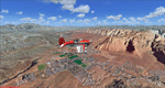
Covers the area between St. George, Utah and Mesquite, Nevada. To the north of St. George
the Pine Valley Mountains with their foothills of scenic red sandstone loom over the city.
St. George Municipal Airport (KSGU) is mostly used for general aviation but is also served by SkyWest Airlines
on behalf of Delta Connection. Because of it's location on a mesa this airport can't be expanded and so a new
airport is currently being built southeast of the city at the site of an abandoned airfield. The opening
is expected in 2011. To the south of the city make sure, you don't miss the Virgin River Gorge where the
Virgin River winds thru a long winding canyon in the transition zone between the red rocks of southern Utahs
Colorado Plateau and Nevadas Mojave Desert. Shortly afterwards you reach Mesquite which is situated just
west of the Arizona stateline. Like nearly all Nevada cities near the stateline Mesquite is home to several
Casinos. Mesquite Airport (67L) lies just north of the city.
High resolution versions of this scenery for FS9 and FSX (much sharper, but larger and multiple downloads)
are available at www.blueskyscenery.com/CNY_South3West6.html . The screenies are taken from the high-res versions,
so expect this version to be slightly more blurry. Thanks to Joop Mak for providing custom AFCADs that
correct airport layouts so that they align with the photo-textures! They are available at www.blueskyscenery.com/AFCADs.html .
YourDonation@Work: Dedicated to Werner, Ralf-Peter and Nels.
| Filename: | St_George_KSGU__Mesquite_67L_UtahNevada_PhotoScene.zip |
| License: | Freeware, limited distribution |
| Added: | 24th March 2010, 19:41:43 |
| Downloads: | 1,658 |
| Author: | Gottfried Razek - blueskyscenery.com |
| Size: | 95.58 MB |
| Category: Flight Simulator 2004 - Scenery | |
| St Marys Municipal KOYM |
|
Images related to this file:
File Description:
FS2004 Scenery - St. Marys Municipal Airport (IATA: STQ, ICAO: KOYM, FAA LID: OYM) is a city-owned public-use airport three miles (5 km) southeast of the central business district of St. Marys, a city in Elk County, Pennsylvania, United States..[1] This general aviation airport is located off South Michael Road in St. Marys. St. Marys Municipal Airport covers an area of 283 acres (115 ha) and contains one runway designated 10/28 with a 4,300 x 75 ft (1,311 x 23 m) asphalt pavement. For the 12-month period ending October 31, 2007, the airport had 6,730 aircraft operations, an average of 18 per day: 85% general aviation, 15% air taxi and
| Filename: | St_Marys_Municipal_KOYM.zip |
| License: | Freeware, limited distribution |
| Added: | 2nd November 2010, 01:35:14 |
| Downloads: | 311 |
| Author: | John B. Loney, Jr. |
| Size: | 947.83 KB |
| Category: Flight Simulator 2004 - Scenery | |
| KILM - Wilmington International Airport - Wilmington, North Carolina (USA) |
|
File Description:
Wilmington International Airport for FS9
John B. Loney, Ray Lunning and Michael Verlin
This Airport started out to be a simple stand alone rendering of the public terminal at KILM. Michael and I entered into a correspondence about this when it became evident that Ray Lunning had designed KILM as a complete airport in 2007. This ended in a collaboration by the three authors. Ray Lunning graciously agreed to allow the use of his original files. Michael Verlin contributed additional input and testing to complete the integration of the various components.
As usual, I welcome any comments. I will try to answer as many as I can.
E-Mail: Website:
[email protected] www.lfssd.net
Have fun and enjoy.
| Filename: | KILM__Wilmington_International_Airport__Wilmington.zip |
| License: | Freeware, limited distribution |
| Added: | 19th August 2013, 17:01:00 |
| Downloads: | 841 |
| Author: | John B. Loney, Ray Lunning and Michael Verlin |
| Size: | 3.18 MB |
| Category: Flight Simulator 2004 - Scenery | |
| Lake Powell, Navajo Mountain (04UT), Utah/Arizona, Photo-Scenery (FS9 & FSX) |
|
Images related to this file:
File Description:
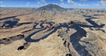
This package contains the center of Lake Powell and the Navajo Nation around Navajo Mountain. It contains remote areas of stunning beauty. Wonderful sandstone formations in bright shades of red and pink. Contains landmarks like the Rainbow Bridge National Monument and the confluence of the Colorado and San Juan Rivers. Extends my Monument Valley scenery to the west and brings you another 3.500 sq km in 4.7m/pix quality. To explore the scenery depart from Navajo Mountain dirt strip (04UT). High resolution versions of this scenery for FS9 and FSX (much sharper, but larger and multiple downloads) are available at www.blueskyscenery.com/CNY_South3West2.html . The screenies are taken from the high-res versions, so expect this version to be slightly more blurry. YourDonation@Work: Joaquin, Donald and Scott.
| Filename: | Lake_Powell_Navajo_Mountain_04UT_UtahArizona_Photo.zip |
| License: | Freeware, limited distribution |
| Added: | 23rd January 2010, 23:06:49 |
| Downloads: | 1,790 |
| Author: | Gottfried Razek - blueskyscenery.com |
| Size: | 91.43 MB |
| Category: Flight Simulator 2004 - Scenery | |
| FS2004 Scenery new Runway 3 at UUEE |
|
File Description:
FS2004 Scenery new Runway 3 (No not Red Square Place) at UUEE-Moscow-Sheremetjewo.
This scenery is thought as visual addition to UUEE-Scheremetjewo Intl DRZEWIECKI DESIGN 2015
because this payware Add-On sets here stringend limitations.
For example there ist no taxiway traffic possible between from Runway 06L-24R via
Taxiway D and 8 from original UUEE scenery, there are as well strong limitations set in
used amount of free RAM therefore I decided to build ADE file only with limited amount
of common objects to bring Rw 06L-24R to life.
*.bgl file should be installed under scenery folder with your other ACFAD/ ADE files.
If you find an error eMail me please via [email protected]. By Bernd Barsch.
| Filename: | FS2004_Scenery_new_Runway_3_at_UUEE.zip |
| License: | Freeware |
| Added: | 10th December 2020, 18:43:15 |
| Downloads: | 184 |
| Author: | Bernd Barsch |
| Size: | 774.15 KB |
| Category: Flight Simulator 2004 - Scenery | |
| CJS4 Moose Jaw Municipal Airport, Saskatchewan, Canada, Version 2 |
|
Images related to this file:
File Description:

Moose Jaw Muni is located 13 km northeast of the city of Moose Jaw, Saskatchewan, Canada. The airfield is a small general aviation airport and hub in the summer for agricultural aircraft. CJS4 Moose Jaw Muni was constructed using GMAX and includes all the airport buidings,signage, fencing, custom ground and runway textures, and lighting. The scenery replicates the pilot activated ARCAL lighting of the airfield approach lights, edge lights, runway and taxiway lights.
This is an update to the July 2007 version of the scenery, which was lost in the AVSIM hack. This is a complete revision of the airport includng new hangars so if you have the orginal file please delete and replace with this version 2 of CJS4 Moose Jaw Municipal airport.
| Filename: | CJS4_Moose_Jaw_Municipal_Airport_Saskatchewan_Cana.zip |
| License: | Freeware |
| Added: | 5th January 2011, 14:55:31 |
| Downloads: | 1,165 |
| Author: | Gregory Putz |
| Size: | 20.36 MB |
| Category: Flight Simulator 2004 - Scenery | |
| CYMJ 15 Wing Moose Jaw |
|
File Description:
CYMJ Moose Jaw is a Canadian Forces Base and headquarters for 15 Wing. This military airfield is situated approximately four miles south of the City of Moose Jaw. The airbase is home to the NATO Flying Training in Canada Program (CT-155 Hawk and CT-156 Harvard II aircraft) and 431 Air Demonstration (Snowbird) Squadron (CT-114 Tutor). This scenery was constructed using GMAX and represents the airport as it was in 2007 / 2008. It includes nearly all the buildings at the airport, taxiway and runway signs, as well as radar and radio transmission structures infield. CYMJ also includes a landclass file to better represent the terrain around the airport, at least as far as the limits of the default landscape will allow.
| Filename: | CYMJ_15_Wing_Moose_Jaw.zip |
| License: | Freeware |
| Added: | 5th May 2008, 01:09:35 |
| Downloads: | 3,090 |
| Author: | Gregory Putz |
| Size: | 4.45 MB |
| Category: Flight Simulator 2004 - Scenery | |
| Marsa Alam Int. Airport (Iata: RMF, Icao: HEMA) |
|
Images related to this file:
File Description:
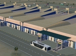
This FS2004 project reproduce the egyptian "Marsa Alam International Airport" (Iata: RMF, Icao: HEMA) located on the Red Sea coast. If you are a holiday-flights pilot, this airport is a “must have†!
In the scenery you'll find all buildings (airport, close surroundings and Port Ghalib resorts), hundred of custom made detailed objects, static and animated vehicles and a photoreal airport background. Each scenery part and object (frame-rate friendly thanks to the low poly design) has photoreal textures and everything is placed in the right position (which has been seen on summer 2016 at the real airport).English extended handbook is included. Watch the screenshot and the demo video on the Albysim youtube channel and enjoy all scenery features (in this free/demo edition some features are limited).
| Filename: | Marsa_Alam_Int_Airport_Iata_RMF_Icao_HEMA.zip |
| License: | Check within download |
| Added: | 29th October 2016, 21:26:52 |
| Downloads: | 1,014 |
| Author: | Albysim Scenery Design / Alberto Di Bolzano |
| Size: | 33.46 MB |
| Category: Flight Simulator 2004 - Scenery | |
| EDBW - Airfield Werneuchen |
|
Images related to this file:
File Description:
In 1945 the airfield was occupied by the Red Army and afterwards used by the 16th Air Army. During the early 1950 s the airfield was expanded under utilisation of the existing infrastructure. By building a 2500m long concrete runway, the necessary conditions to allow the deployment of the IL-28 and Jak-28 bomber squadrons, were created.
Since 1971 the airfield was further expanded, amongst other things special arms depots of the type Granit 2 were built. Simultaneously the reconnaissance aircraft MiG-25 was based in Werneuchen.
In 1991 the airfield was left by the GSSD and afterwards in civil use. Today there are a concrete plant and a solar park in the northern part. The runway was shortened to 1500m.
This scenery shows the airfield situation in a period some when between 2012 and 2013.
| Filename: | EDBW__Airfield_Werneuchen.zip |
| License: | Freeware |
| Added: | 4th June 2014, 13:29:43 |
| Downloads: | 623 |
| Author: | Frithjof Koch, Matthias Ewald, Volker Loew |
| Size: | 7.56 MB |


© 2001-2026 AVSIM Online
All Rights Reserved
Privacy Policy |