
Where Flight Simulation Enthusiasts Gather from Around the World!
AVSIM Library - Search Results

| Category: Flight Simulator 2004 - Scenery | |
| Paul Farm Field CF16 in Ontario, Canada |

|
Images related to this file:
File Description:
Paul Field is on the south side of Highway 174, four miles east of Hawkesbury Windover Field and five miles west of the town of Hawkesbury; the town is on the south bank of the Ottawa River approximately midway between Ottawa and Montreal. I first saw the field when I was on the way to Windover a few years ago. I asked some old timers at Windover who the grass strip belonged to and they said "Paul". It may not be what Paul calls it, but it's the only name I know it by. Probably Paul doesn't call it anything, it's just the field where he keeps his plane. There is a grass runway approximately north-south and 2,000 feet long, and two hangars which look to be an old one and a new one. In real life the runway isn't so north-south as it lines up with the farm fields alignment which is of course in FS is auto-generated and not actuality-accurate.
| Filename: | Paul_Farm_Field_CF16_in_Ontario_Canada.zip |
| License: | Freeware, limited distribution |
| Added: | 6th February 2010, 02:36:49 |
| Downloads: | 290 |
| Author: | Roger Wensley |
| Size: | 997.17 KB |
| Category: Flight Simulator 2004 - Scenery | |
| Wakefield riverfront in Quebec Canada |
|
Images related to this file:
File Description:
The village of Wakefield is 18 miles northwest of Ottawa on the west shore of the Gatineau River, and I seem to have been flying north up that river from Rock cliffe for years, past the village in a bend of the river just a few miles north of Cascades float base. It is where the tourist steam train goes through, and by "through" I mean that literally as the tracks are at the side of the main street, and one of the things it goes past is the Black Sheep Inn which hosts Canadian musical groups and individuals at the weekends. Though the radio in Ottawa uses the name in English it is actually and visibly called "Mouton Noir" on the sign. There is no airfield, and no float base. There aren't even all the buildings that are on the riverfront as it stretches further south and north. There is a public dock where you can tie up. Apart from the fact that the idea caught my fancy one afternoon outside the Mouton Noir I really can't think why I made this.
| Filename: | Wakefield_riverfront_in_Quebec_Canada.zip |
| License: | Freeware, limited distribution |
| Added: | 1st May 2010, 00:39:24 |
| Downloads: | 406 |
| Author: | Roger Wensley |
| Size: | 11.23 MB |
| Category: Flight Simulator 2004 - Scenery | |
| Mountain View dirt strip in Ontario Canada |
|
File Description:
For a start this is not Mountain View CPZ3, which is in Ontario but around 120 miles south, near Trenton and Lake Ontario. This is a dirt strip between Pettawawa and Deep River, close to the Ottawa River, and the only reason I have called it Mountain View is that that's the name of a group of houses very close by. So a dirt strip, surprisingly long at what timed out at around 3,500 feet, and with one hanger at the eastern end.
| Filename: | Mountain_View_dirt_strip_in_Ontario_Canada.zip |
| License: | Freeware |
| Added: | 10th November 2008, 23:24:14 |
| Downloads: | 317 |
| Author: | Roger Wensley & Jim Turner |
| Size: | 523.58 KB |
| Category: Flight Simulator 2004 - Scenery | |
| Ruissellet Strip CF03 in Ontario, Canada |
|
Images related to this file:
File Description:
Ruissellet Strip is in Ontario just a few miles southeast of ottawa. It is a real grass strip, cut out of the trees next to the house of its owner, and close to Russel Farm and Indian Creek (both also real, and posted). This version has a different name as I misread the name on the road map, so it replaces Russellet which should be deleted from your system. This version has the right hangar now that I revisited and identified the correct hangar photo that I took the first time I was there. Drat.
| Filename: | Ruissellet_Strip_CF03_in_Ontario_Canada.zip |
| License: | Freeware, limited distribution |
| Added: | 15th July 2012, 19:33:15 |
| Downloads: | 212 |
| Author: | Roger Wensley |
| Size: | 8.12 MB |
| Category: Flight Simulator 2004 - Scenery | |
| CYGK (2008) - Kingston (Norman Rogers) Airport, Ontario, Canada |
|
Images related to this file:
File Description:
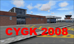
Kingston V2 (2008) - GMAX modeled scenery with custom ground textures. The airport was modeled in its 2008 state.
Kingston Airport or Kingston/Norman Rogers Airport (IATA: YGK, ICAO: CYGK) is located 4.3 nautical miles (7.96 km) west of the downtown of Kingston, Ontario, Canada. CYGK is now as the only airport (except CFB Trenton - restricted) between Toronto, Montreal, and Ottawa that has an ILS approach making it a preferred alternate airport to most aviators.
(This is a re-upload of the scenery to replace the original that was lost in the AVSIM hack. No changes have been made)
| Filename: | CYGK_2008__Kingston_Norman_Rogers_Airport_Ontario_.zip |
| License: | Freeware, limited distribution |
| Added: | 16th May 2010, 10:04:29 |
| Downloads: | 3,292 |
| Author: | Keith Murphy |
| Size: | 25.68 MB |
| Category: Flight Simulator 2004 - Scenery | |
| Boundary Bay CZBB - Traffic |
|
Images related to this file:
File Description:
This traffic file is for Boundary Bay, and has five planes making touch and goes at this airfield with its five training companies. The planes are FS standard Cessna 172 (2 of them) and Cessna 182 and Piper Cherokee, and a Piper Super Cub which can be downloaded from Avsim. For the Cub look for the pa18_v3 zip by J. E. Narcijo and install it; I presume you know how to do that.
There are new scenery bgl's as I have added more parking spots for AI. The pic shows a Cessna 150, but that you won't be able to download as it is a custom texture of the plane that I learnt to fly on at Rockcliffe Flying Club in Ottawa. You should already have installed my Boundary Bay post (boundary_bay.zip).
| Filename: | Boundary_Bay_CZBB__Traffic.zip |
| License: | Freeware, limited distribution |
| Added: | 13th May 2011, 15:14:44 |
| Downloads: | 554 |
| Author: | Roger Wensley |
| Size: | 950.48 KB |
| Category: Flight Simulator 2004 - Scenery | |
| Factory Field CF40 in Quebec Canada |
|
Images related to this file:
File Description:
Factory Field (my name for it) is in Quebec on highway 321 a few miles north of St Andre Avellin, and 40 miles ENE of Ottawa. The runway is 3,500 feet long and asphalt and went out of regular use in the early 1990's when the airfield was closed. It was sold in 1995 to a company (ELP) that has built up a factory for manufacturing and fitting snow ploughs and other pneumatically operated equipment to trucks, and who now use the runway for testing their snow ploughs. In between times, as it is not marked closed with an "X", it is also occasionally used by customers who fly in, usually to get the drivers there to take delivery of completed trucks. The surface is good and there are no obstructions but also no markings, though with 3,500 feet of 100 feet wide asphalt there is plenty of space and it doesn't much matter.
| Filename: | Factory_Field_CF40_in_Quebec_Canada.zip |
| License: | Freeware, limited distribution |
| Added: | 13th May 2010, 22:11:41 |
| Downloads: | 347 |
| Author: | Roger Wensley |
| Size: | 1.27 MB |
| Category: Flight Simulator 2004 - Scenery | |
| Maniwaki CYMW in Ontario Canada |
|
Images related to this file:
File Description:
Maniwaki airfield is seven miles south of the town of Maniwaki and some 60 miles north of Ottawa, up the Gatineau River. There is a generous 5,000 feet of runway 03/21 that is 150 feet wide and in bad condition, so bad that there are now almost no markings of any sort (even a centre line, the apron has more paint than the runway!) and the whole lot is going to be redone next summer. The apron is large, and in the summer accomodates two Bombardier CL 415 fire fighting amphibians, which is why there is a large access platform loitering on the apron. There are only five hangars on the field with another one tucked into the trees behind a house. The hangars and the office/cafe building have been modelled specifically for this field. There are further buildings to the north which are not actually on the airfield and which house fire department personnel.
| Filename: | Maniwaki_CYMW_in_Ontario_Canada.zip |
| License: | Freeware, limited distribution |
| Added: | 14th February 2010, 23:12:27 |
| Downloads: | 505 |
| Author: | Roger Wensley |
| Size: | 4.56 MB |
| Category: Flight Simulator 2004 - Scenery | |
| Shea Field CSF7, Casselman Ontario Canada |
|
Images related to this file:
File Description:
Shea Field is a recently-licensed privately-owned grass airfield in Ontario, 25 miles southeast of ottawa, and south of Highway 417. When I visited I was greeeted by the horse, peering around the end of it's stable shed at the corner of apron and runway. I walked over to the house and rang the doorbell and the dog said hello and that exhausted all social contact. The hangar is large but I have no idea what is inside. There was one plane parked on the apron with a skirt of uncut grass so presumably it hasn't flown for a few months. It was a Citabria in what looked like good condition; I don't have a Citabria to park there so I put a Cub. My favourite building is the old barn, leaning to one side as if seeking support for an elbow. To the north there are some farm sheds and grain silos, and to the northwest a tall mast; avoid it. To find the field without a gps follow the 417 and look for the tall mast just west of a major highway wiggle.
| Filename: | Shea_Field_CSF7_Casselman_Ontario_Canada.zip |
| License: | Freeware, limited distribution |
| Added: | 5th August 2012, 13:35:12 |
| Downloads: | 214 |
| Author: | Roger Wensley |
| Size: | 2.62 MB |
| Category: Flight Simulator 2004 - Scenery | |
| Frozen & Landable Lakes & Rivers for All Canada Winter Ski Operations |
|
Images related to this file:
File Description:
This "freezes" ALL Canadian lakes and rivers for winter flying and means they can be landed on with skis or wheels. This edition covers all of Canada plus parts of the USA along the border, including Michigan, Wisconsin, Minnesota, North Dakota, and Montana. It is reversible with an "untick" in the FS scenery library. I have spent some time making sure that the sea and the inlets along the coast do not get frozen too, and also some of the lakes that are close to the coast and rarely get cold enough to freeze over. Along the north shore I went for the peak of the winter with sea ice all the way to the permanent polar cap; this is not totally realistic as there is usually a partially open lead along the coast, but this would be difficult to replicate convincingly. This is really for use with Ultimate Terrain, though it will work without it. The pics show Rockcliffe in the winter with the frozen Ottawa River for real and in FS for comparison; without UT the river would not be in the right place.
| Filename: | Frozen__Landable_Lakes__Rivers_for_All_Canada_Wint.zip |
| License: | Freeware, limited distribution |
| Added: | 15th November 2010, 01:01:36 |
| Downloads: | 603 |
| Author: | Roger Wensley |
| Size: | 871.82 KB |
© 2001-2026 AVSIM Online
All Rights Reserved
Privacy Policy |