
Where Flight Simulation Enthusiasts Gather from Around the World!
AVSIM Library - Search Results

| Category: Flight Simulator 2004 - Scenery | |
| LTFD2008v1.3 - Edremit Korfez Airport |

|
File Description:
----What's new with v1.3 ?
*PAPI added in accordance with the current charts
*Electric poles added on both sides of the runway in accordance with the current charts
*Static GA aircraft grouped as north(kuzey),west(batý) and east(dogu)
*Extra parking space created in the apron
*Door signs have been updated with the real signs
*Security towers added in vicinity of the field
*Also improvements and corrections have been made on the models
*Airfield's landclass updated(Fatih Koz)
Have safe flights.
| Filename: | LTFD2008v13__Edremit_Korfez_Airport.zip |
| License: | Freeware |
| Added: | 28th April 2008, 22:45:39 |
| Downloads: | 1,755 |
| Author: | Gökhan Bayrakdar |
| Size: | 7.81 MB |
| Category: Flight Simulator 2004 - Scenery | |
| 28A - Goose Creek Airport |
|
Images related to this file:
File Description:
FS2004 Scenery--Goose Creek Airport (28A), is a small GA airfield located near Indian-Trail, North Carolina (NC), USA. It is home to Pressley Aviation Inc., a popular flight-training school. This scenery package uses common objects from the Rwy12 and EZ-Scenery libraries (not included) and these are required for correct scenery display. A good high-quality terrain mesh from FSGenesis or equivalent supplier is also recommended for best results. It will work with the default FS2004 terrain engine as well.
| Filename: | 28A__Goose_Creek_Airport.zip |
| License: | Freeware |
| Added: | 30th October 2011, 14:42:17 |
| Downloads: | 737 |
| Author: | Glenn Mullis |
| Size: | 3.81 MB |
| Category: Flight Simulator 2004 - Scenery | |
| LPMO Morargil Airfield, Portugal |
|
Images related to this file:
File Description:
LPMO Morargil Airfield.
This is a certified airfield in the neighbourhood of Mora Village (North Alentejo) in the middle south of Portugal, about 4.5 miles SSE from Montargil dam. The house painting respects the traditional Alentejo houses.
This scenery is only compatible with Portugal Terrain from PTSIM (http://www.ptsim.com) and is based on digital pictures taken at the place, accurate real measures by Aerodromos de Portugal (http://www.pelicano.com.pt/zmapa.html) and Google Earth. Freeware. For Microsoft FS2004.NOT tested for FSX
| Filename: | LPMO_Morargil_Airfield_Portugal.zip |
| License: | Freeware |
| Added: | 1st March 2013, 22:39:29 |
| Downloads: | 375 |
| Author: | Joao A. Graca Ferreira |
| Size: | 8.67 MB |
| Category: Flight Simulator 2004 - Scenery | |
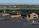
| CYKY - Kindersley Regional Airport, Saskatchewan, Canada |
|
Images related to this file:
File Description:
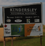
CYKY Kindersley Regional Airport is located in the west-central part of the province of Saskatchewan, Canada. The airport is located 4.6 km north of the town. The scenery consists of custom models of all the buildings at the airport, runway signs, runway and taxiway lighting, rotating beacon, static aircraft, vehicles, animated highway traffic and oil pump jacks, trees that properly change with the seasons, custom tarmac and runway textures, and seasonal ground textures for the airport and surrounding area.
| Filename: | CYKY__Kindersley_Regional_Airport_Saskatchewan_Can.zip |
| License: | Freeware |
| Added: | 14th June 2012, 13:44:10 |
| Downloads: | 1,288 |
| Author: | Gregory Putz |
| Size: | 84.58 MB |
| Category: Flight Simulator 2004 - Scenery | |
| Gallatin Field - Bozeman, MT |
|
Images related to this file:
File Description:
Scenery for Gallatin Field in Bozeman, Montana. Scenery was created for FS9, but should work in FSX. It was created completely in Gmax and separately compiled, so no other libraries are needed. Also included is a landclass file to create the town of Belgrade immediately southwest of the airport, which didn't even exist in the default scenery. Landclass was also updated to change the areas north of the airport to it's actual agricultural use rather than the small forests depicted in the default.
| Filename: | Gallatin_Field__Bozeman_MT.zip |
| License: | Freeware, limited distribution |
| Added: | 28th December 2009, 11:35:54 |
| Downloads: | 2,923 |
| Author: | Gary Widup |
| Size: | 1.28 MB |
| Category: Flight Simulator 2004 - Scenery | |
| Kivitoo, Paulatuk, Qikiqtarjuak, Rowley Island, & West Baffin, adapted for FSGenesis 76m North Canada Terrain Mesh |
|
Images related to this file:
File Description:
These are replacement bgl's to convert five northern Canada fields for use with the FSGenesis 76m terrain mesh for northern Canada. The five are Kivitoo CWFK, Paulatuk CYPC, Qikiqtarjuak CYVM, Rowley Island CWFR, and West Baffin CWFW. These are not stand-alone, and the presumption is that you have already downloaded and installed the previously posted sceneries. This installation consists solely of replacing the existing scenery bgl's with the new. This is the last post of adapted northern airfields (unless more are discovered needing revision) and observations regarding and any further corrections that are required would be welcomed.
| Filename: | Kivitoo_Paulatuk_Qikiqtarjuak_Rowley_Island__West_.zip |
| License: | Freeware, limited distribution |
| Added: | 18th September 2017, 22:28:33 |
| Downloads: | 87 |
| Author: | Roger Wensley |
| Size: | 3.02 MB |
| Category: Flight Simulator 2004 - Scenery | |
| Alaska South Slope 10; Port Clarence KPC |
|
Images related to this file:
File Description:
There are four main northwestern Alaska towns which are serviced by Alaska Airlines, and from which local flights spread out. The northernmost is Barrow. Southwest of Barrow is Kotzebue, then Nome, and the furthest south is Bethel (not yet made). This is the third in a series for local flights from Nome, and it is on the coast around 40 miles east of Wales, and 65 miles northwest of Nome. There are two other airfields around a large lagoon that is almost totally enclosed from the sea, and Port Clarence is on the end of the enclosing spit. Port Clarence was, until the LORAN navigation system went out of use, a Coastguard Station that had a LORAN transmitter, with an impressive mast that was 1,350 feet tall. It "was" as the mast was demolished in 2010, after the LORAN systems had been closed down in stages (LORAN-A in 1980 in the US, LORAN-C in 2010). In the meantime the runway had been lengthened to around 8,500 feet, and continued to be used by the Coastguard. Port Clarence has a population of 24, in theory, though presumably the census information refers to Coastguard personnel in the buildings of the LORAN station. The date for this scenery is anytime you like so long as it is before 2010 as the mast is still there. The AI includes Coastguard C-130 Hercules and helicopter flights, plus a weekly fuel delivery by Everts Air Fuel in a fancy colour scheme (Wednesday) and a daily visit by Bering so Coast Guards can go to civilisation in Nome.
| Filename: | Alaska_South_Slope_10_Port_Clarence_KPC.zip |
| License: | Freeware, limited distribution |
| Added: | 23rd October 2016, 18:53:14 |
| Downloads: | 231 |
| Author: | Roger Wensley |
| Size: | 3.05 MB |
| Category: Flight Simulator 2004 - Scenery | |
| Nanisivik CYSR and Arctic Bay CJX7 in Nunavut, Canada |
|
Images related to this file:
File Description:
Nanisivik is an airfield in the north of Baffin Island, 470 miles north of the Arctic circle. It was built to service a zinc and lead mine that was opened in 1976 as Canada's first Arctic mine, now closed and dismantled. The deep water Strathcona Sound has been ear-marked by the Canadian government for development as a naval base, so I have left the large ore storage shed and the jetty in place. The airfield is at 2,106 feet on the top of the Borden Peninsula hills with a lighted 6,400 feet of 150 feet wide gravel runway runway aligned 11/29. There is a terminal and other maintenance buildings, and First Air have a building there from when the mine generated a lot of traffic and jets were used. Arctic Bay is a village 11 miles west of Nanisivik airfield with a population of around 690 which also uses the Nanisivik airfield. There is another gravel strip much closer to the village that is called Arctic Bay CJX7, but this is smaller with only 1,500' of 50' wide gravel and has no facilities of any sort. The village is partly dependent on visiting sports hunters and other limited tourist visits. At almost 73 degrees north the average year will have only four or even three months where the average high is above freezing. The buildings on the field have been modelled specifically for this scenery, and as in real life there is only JetA available. The AI visiting aircraft are a Kenn Borek Twin Otter and a First Air 42-300. As Nanisivik is in the "Northern Domestic Airspace" the runway is signed in "true" bearings and not magnetic as magnetic compasses become unreliable close to the magnetic pole.
| Filename: | Nanisivik_CYSR_and_Arctic_Bay_CJX7_in_Nunavut_Cana.zip |
| License: | Freeware, limited distribution |
| Added: | 28th May 2011, 19:59:18 |
| Downloads: | 494 |
| Author: | Roger Wensley |
| Size: | 2.64 MB |
| Category: Flight Simulator 2004 - Scenery | |
| Penshaw Monument Addon |
|
File Description:
The monument is situated on Penshaw Hill, overlooking the River Wear. Its high position means it is a familiar landmark for people over a wide area of north-east England.
The monument itself was erected in 1844, designed by John and Benjamin Green and modelled on the Theseum at Athens. It is dedicated to John George Lambton, first Earl of Durham and the first Governor of Canada.
Penshaw Hill, on which the monument is built, is associated with the local legend and song about the Lambton Worm
| Filename: | Penshaw_Monument_Addon.zip |
| License: | Freeware |
| Added: | 14th November 2003, 00:11:39 |
| Downloads: | 1,319 |
| Author: | Fred Gregory |
| Size: | 128.53 KB |
| Category: Flight Simulator 2004 - Scenery | |
| St.Joseph-de-la-Rive |
|
File Description:
This is the scenery of the village of St.Joseph-de-la-Rive (fictitious rendering) on the North Shore of the St.Lawrence river. It includes the village, a small grass stip on the cliff behind the village, lit at night with kerosene torches and also with more buildings and lots of candies. It also includes the docks for the ferry that goes to my other scenery Île-aux-Coudres and the dock there as well. Those sceneries are very close. No other file is necessary to install.
| Filename: | StJosephdelaRive.zip |
| License: | Freeware |
| Added: | 18th November 2003, 16:52:19 |
| Downloads: | 1,209 |
| Author: | Léon Louis |
| Size: | 5.07 MB |
© 2001-2026 AVSIM Online
All Rights Reserved
Privacy Policy |