
Where Flight Simulation Enthusiasts Gather from Around the World!
AVSIM Library - Search Results

| Category: Flight Simulator 2004 - Scenery | |
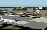
| Alverca AB, LPAR (near Lisbon, Portugal) including AI-Package |

|
File Description:
About 10 NM north of Lisbon City (Portugal) there is this beautiful, close to the Atlantic Ocean located Portuguese Airbase. The Alverca AB scenery goes along well with the Project Lisbon Photoreal PLPv3.2 scenery available at avsim. The included AI-Package contains: USAF Douglas C-47 Dakota and C-64 Skymaster, Breitling Lockheed L-1049 Super Constellation, FAP (Forca Aerea Portuguesa) Lockheed C-130H and T-33A, Lockheed-Martin F-16C, North American F-86F, FAP and GAF (German Air Force) Nord-Aviation Noratlas and the new GAF British-Aerospace Eurofighter Typhoon. The above airplanes perform touch and goes at the local airbase per attched flightplan. This scenery was made with EZ-Scenery. No FSE or other payware is required. Gentlemen, line up and standby for takeoff clearance!
| Filename: | Alverca_AB_LPAR_near_Lisbon_Portugal_including_AIP.zip |
| License: | Freeware, limited distribution |
| Added: | 4th April 2006, 22:14:40 |
| Downloads: | 8,644 |
| Author: | Klaus Jone |
| Size: | 30.16 MB |
| Category: Flight Simulator 2004 - Scenery | |
| Cape Dyer CWFD in Nunavut, Canada |
|
Images related to this file:
File Description:
Cape Dyer is on the southeast corner of Baffin Island, around 120 miles east of Pangnirtung at approximately N66 45 W61 30. There is a fine view north up the Davis Strait between Baffin Island and Greenland, and this is the whole reason for the airfield's existance as it was built to support the construction and operation of a DEW line radar station, which has now been updated to a North Warning System site. There are two camps; the upper camp is on the east side of the Cape and is where the radars are located, linked by a gravel road to the lower camp, which is on the west and more sheltered side of the Cape on the clifs above Sunneshine Fjord. The runway is 5,000' of 150' wide gravel, and it is lighted and at 1,320' feet ASL. Cape Dyer is now listed as abandoned in the Canada Flight Supplement. It is, however, still there and presumably is still used for access to the North Warning System equipment, which is automated and generally unmanned. The buildings were modeled for this scenery and include a hanagar large enough to accommodate a C-130. Ultimate Terrain is not required as it does not cover northern Canada.
| Filename: | Cape_Dyer_CWFD_in_Nunavut_Canada.zip |
| License: | Freeware, limited distribution |
| Added: | 21st June 2011, 19:30:07 |
| Downloads: | 488 |
| Author: | Roger Wensley |
| Size: | 1.9 MB |
| Category: Flight Simulator 2004 - Scenery | |
| CYDA - Dawson City - Yukon Territory, Canada |
|
Images related to this file:
File Description:
Dawson City is in the Yukon Territory, Canada, 140 miles south of Old Crow and about the same north of Whitehorse. The town has a population of just over 1,300 and is on the bank of the Yukon River; it is busy with nearby gold mining and tourism. There are regular flights by Air North, the Yukon airline, and I have included them in the AI along with ConAir and GA. Thanks go to Hernan for his Air North textures. The airport is beside the Klondike Highway that links Dawson City to Whitehorse, a few miles southwest of the town and the river. The runway approaches are steeper than most because of the surrounding hills and the Canada Flight Supplement notes that use is restricted to daylight hours, with some exceptions including emergencies. Runway 20 has right hand circuits. The runway is gravel and just over 5,000 feet long, aligned 02-20. There is a second apron for the activities of ConAir etc in the summer fire-fighting months. The "masts" are actually for fire hose drying; the ends of several 50 feet lengths are attached to a circular holder that is then pulled up to the top of the central pole.
| Filename: | CYDA__Dawson_City__Yukon_Territory_Canada.zip |
| License: | Freeware, limited distribution |
| Added: | 27th December 2014, 20:31:31 |
| Downloads: | 377 |
| Author: | Roger Wensley |
| Size: | 3.96 MB |
| Category: Flight Simulator 2004 - Scenery | |
| Kaltag KAL in Alaska |
|
Images related to this file:
File Description:
Kaltag is a small village on the west bank of the Yukon River, around 65 miles east of the coast at Unalakleet and about 40 miles south of where the river turns from north-south to east-west, east being upstream towards the distant Fairbanks. The population is just under 200 and living from fishing and the land. The airfield is close by and has a gravel runway aligned 21-3 and just under 5,000 feet long. Apart from the airfield itself, and it's buildings, this scenery modifies the local land class, adds village buildings while reducing the village size to reality, and creates a new airfield background. Kaltag is located on the edge of three different airlines coverage areas, and is served by Bering Air from the northwest, ERA from the southwest, and also by Wright Air from Fairbanks in the east. These are included in the AI.
A note here about my scenery making. This is post number 507 and there will not be many more to follow this as I am almost at the end of the photos I either took or found for scenery purposes. There is a limit to what can be located online and I have already been making use of the little there is; eg Unalakleet. So, if you are near an airport (preferably Canadian or Alaskan) and have a camera..... Let me know.
| Filename: | Kaltag_KAL_in_Alaska.zip |
| License: | Freeware, limited distribution |
| Added: | 20th August 2019, 19:04:35 |
| Downloads: | 101 |
| Author: | Roger Wensley |
| Size: | 3.57 MB |
| Category: Flight Simulator 2004 - Scenery | |
| HLLQ El Beida/Labraq |
|
Images related to this file:
File Description:
Googly scenery for HLLQ El Beida/Labraq - a joint civilian and military airport
near the north coast of Libya that is poorly provided for in Flight Simulator
2004. These scenery files add taxiways, aprons, buildings and other airport
features, so that you and your "AI" traffic can land, taxi, park and take off
in a realistic manner.
The city of Al Beida, or Al Bayda' or El Beda or Al Baidhah (depending on who
you are) has achieved its own airport status by using the end of a dead runway
at Labraq Air Base. In turn the airbase has contracted to use the opposite end
of the runway as its base of activity. The city is served by jets of Libyan
Airways and turboprop craft of Air One Nine and Ghadames Air Transport.
The scenery does not purport to be ultra-accurate. Based on high-detail satellite
imagery from Google Earth, the layout is proportionally correct but the added
airport features, such as buildings, are built from default Microsoft objects
and add-on libraries so will not look like the real thing.
You are not obliged to download and install any additional scenery libraries,
but to enjoy this scenery in its entirety, you may wish to. It will work fine,
with or without. [File re-uploaded at request of AVSIM]
| Filename: | HLLQ_El_BeidaLabraq.zip |
| License: | Freeware |
| Added: | 28th May 2010, 20:42:26 |
| Downloads: | 1,286 |
| Author: | John Hinson |
| Size: | 73.79 KB |
| Category: Flight Simulator 2004 - Scenery | |
| Z19O - Hamat Airbase - Batroun, Lebanon |
|
Images related to this file:
File Description:
Hamat is a village near the coast of Lebanon, around 25 miles north of Beirut. The airport runway was built during the civil war to the west of Hamat in the late 1970's, between Hamat and another village called Wuajh Al Hajar. The intention was have an alternative to Beirut airport, which could be (and often was) closed by shell fire from any or all of the sides involved in the civil war, or by bombing by those who were not directly part of the civil war but occasionally joined in. It has been used for drag racing, occasional freefall parachuting (this may continue) and is now an army base with mostly helicopter use. The runway is around 5,600 feet of asphalt, 90 feet wide and aligned 02/20. There is no lighting. The apron is set well back from the runway and has hangars at each end; one set is four hangars long, and at the other end of the apron there are three hangars. There are also the remains of some radar to the west of the apron, bombed (in 1982?). The runway has been repositioned and the surrounding landclass modified to reduce one village to it's approximate actual size and to create a second village which was missing entirely. An intrusive road has been deleted, and the airfield grass area also modified.
| Filename: | Z19O__Hamat_Airbase__Batroun_Lebanon.zip |
| License: | Freeware, limited distribution |
| Added: | 23rd May 2015, 10:03:10 |
| Downloads: | 223 |
| Author: | Roger Wensley |
| Size: | 8.53 MB |
| Category: Flight Simulator 2004 - Scenery | |
| PAEN, PAEX, 3AK4, 30AK, 52AK - Alaska, USA |
|
Images related to this file:
File Description:
The town of Kenai is on the east coast of Cook Inlet, 60 miles southwest of Anchorage. The airport is in the northern part of the town, with a runway aligned 1-19, 7,550 feet long and 150 feet wide (with an ILS on 19). A second runway is gravel, 2,000 feet long and for winter use by ski planes. There is also a water runway, and all three are aligned the same and called "1 left-19 right" (the main runway) "1 right-19 left" (gravel) and "1 water-19 water". The taxiways are extensive and designed for a far larger traffic than the airport has today, though even now the airport is fairly busy. In FS9 a water runway for AI cannot work with an ATC control tower; the water part of PAEN has therefore been separated into another call sign PAEX which has ONLY the water runway; the tower will therefore direct the plane that makes contact to use the water runway. The PAEN airport runway has taxiway connections at each end and also two intermediates; at the northern end there are in fact two so a total of 5; B, C, D, E, and F; there is an airport diagram included. GA traffic goes to one of two parking aprons, both at the southern end, and at the far southern end there is the hangar for the Civil Air Patrol. The AI includes aircraft from my previous Alaska posts, as Kenai is where I sent them when they departed from, for instance, Palmer. Airlines and cargo companies that operate from and to Kenai are included in the AI: ERA (which has recently changed it's name), Grant Aviation, Air North, Wings of Alaska, North Star Air, and a small local company Air Supply Alaska, along with Fedex, UPS, Everts, and Northern Air Cargo. There is also GA and float AI. Nearby smaller airfields are included, partly because one of them was dramatically misaligned in FS9.
| Filename: | PAEN_PAEX_3AK4_30AK_52AK___Alaska_USA.zip |
| License: | Freeware, limited distribution |
| Added: | 26th December 2015, 15:33:19 |
| Downloads: | 482 |
| Author: | Roger Wensley |
| Size: | 23.08 MB |
| Category: Flight Simulator 2004 - Scenery | |
| Igloolik CYGT update (to FSGenesis 76m North Canada Terrain Mesh revision) |
|
Images related to this file:
File Description:
These are replacement bgl's and textures to correct the already posted Igloolik CYGT for use with the FSGenesis 76m terrain mesh for northern Canada. I noticed after posting that the PAPI were incorrectly positioned, and after fixing that I went on and updated the windsocks, added the wheeled roller/snow clearer that all gravel fields need in the north, and updated the signage to give the true headings for the runway. This is not stand-alone, and the presumption is that you have already downloaded and installed the previously posted scenery. Installation consists solely of replacing the existing scenery bgl's with the new, and adding the new signage textures.Any comments regarding further corrections that are required would be welcomed.
| Filename: | Igloolik_CYGT_update_to_FSGenesis_76m_North_Canada.zip |
| License: | Freeware, limited distribution |
| Added: | 30th September 2017, 20:11:03 |
| Downloads: | 84 |
| Author: | Roger Wensley |
| Size: | 1.03 MB |
| Category: Flight Simulator 2004 - Scenery | |
| Beaverton CBV2 and Beaverton North fields near Lake Simcoe, Ontario, Canada |
|
File Description:
The town of Beaverton is on the east shore of Lake Simcoe. Just a bit over three miles to the east of the town is Beaverton airfield CBV2, with a grass runway 12/30 that appears to be 2,100 feet long, rather than the listed 2,400 feet. The field is new enough to be omitted from FS9, and though there are plans to build hangars I don't know if anything has been built in the year since I last saw it, so the only buildings here are farm-related. The second field to the northwest is Beaverton North, which is privately owned. It has 2,000 feet or so of grass runway and a large hangar (or storage shed?) and that about sums up all I know about it. There are two airfield scenery folders, two landclass files to provide the grass airfield areas, and a third landclass folder that modifies the terrain around Beaverton CBV2.
| Filename: | Beaverton_CBV2_and_Beaverton_North_fields_near_Lak.zip |
| License: | Freeware |
| Added: | 3rd February 2010, 02:16:36 |
| Downloads: | 324 |
| Author: | Roger Wensley |
| Size: | 1.05 MB |
| Category: Flight Simulator 2004 - Scenery | |
| Canyonlands National Park, The Maze-North, Utah, Photo-Scenery (FSX too) |
|
Images related to this file:
File Description:
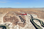
This is a re-upload of a package that was corrupted during the crash of the AVSIM library. The Maze is the wildest and least accessible district of Canyonlands National Park. It is a perplexing jumble of canyons that has been described as a '30 sq miles puzzle in sandstone'. The Maze covers the area west of the Green River and north of the Colorado River. Getting to most locations requires multiple hours of 4WD road driving. Hiking trails usually require multi day backpack trips.
Too strenous? Let's go flying! Checking out the area from an eagles perspective is certainly a stunning experience. The colors are awesome and the landforms are of breathtaking beauty. The scenery extends my Arches National Park scenery to the west and brings you another 3.500 sq km in 4.7m/pix quality. YourDonation@Work: Dedicated to Frans, Francois and James. Thanks!
| Filename: | Canyonlands_National_Park_The_MazeNorth_Utah_Photo.zip |
| License: | Freeware, limited distribution |
| Added: | 31st December 2009, 11:01:39 |
| Downloads: | 2,371 |
| Author: | Gottfried Razek - blueskyscenery.com |
| Size: | 92.88 MB |
© 2001-2026 AVSIM Online
All Rights Reserved
Privacy Policy |