
Where Flight Simulation Enthusiasts Gather from Around the World!
AVSIM Library - Search Results

| Category: Flight Simulator 2004 - Scenery | |
| CYCS - Chesterfield Inlet - Nunavut, Canada Modified V1 |

|
Images related to this file:
File Description:
This version of Chesterfield Inlet corrects the VASI position on the runway, and also updates the taxiway edge lights to a newer and smaller version which is more realistically sized. This is a complete version and does not require you to have installed the old version. There is new AI, which is for Arviat, Whale Cove, and Chesterfield Inlet; this enlarges on and replaces the version posted with Whale Cove so use this one. The First Air and Calm Air flights also visit Rankin Inlet (made by Sid) and the GA flights originate in Rankin Inlet. There is a revised Rankin Inlet bgl so that the planes are allowed to use the gates. Chesterfield Inlet is a small village on the west coast of Hudson Bay, with a population of 340 or so. It is the oldest community in Nunavut and was established around a Hudson Bay Company post in 1911. It is 55 miles north of Rankin Inlet (Sid and Pete's post). The airfield is close to the village and has a gravel runway 3,600 feet long aligned 124T/304T (true, not magnetic).
| Filename: | CYCS__Chesterfield_Inlet__Nunavut_Canada_Modified_.zip |
| License: | Freeware, limited distribution |
| Added: | 23rd August 2014, 11:22:36 |
| Downloads: | 198 |
| Author: | Roger Wensley |
| Size: | 3.3 MB |
| Category: Flight Simulator 2004 - Scenery | |
| Kugluktuk CYCO in Nunavut, Canada |
|
Images related to this file:
File Description:
Kugluktuk is on the coast of northern mainland Canada on the mouth of the Coppermine River. It is around 250 miles west of Cambridge Bay and 200 miles south of Ulukhaktok. Tuktoyaktuk is 450 miles west. Kugluktuk used to be called Coppermine as copper was mined along the banks of the river and used for spear and arrow heads, and this attracted a semi-permanent population. The population now numbers around 1,450. The airfield is inland from the village and the 5,500 feet of 100 feet wide gravel runway is aligned 121T/3301T where T stands for "true" as opposed to magnetic in the Northern Domestic Airspace. Both JETA-1 and 100LL are available, dispensed by a truck as the storage tanks are just off the northern edge of the field. There are flights by First Air and Canadian North and the AI includes a daily flight of each, plus a cargo visit by Buffalo; the closest large city is Yellowknife, 375 miles south. I should have mentioned a long time ago that to see the apron lights working requires you to have the "lights_ss_v2" by Sidney Schwartz installed.
| Filename: | Kugluktuk_CYCO_in_Nunavut_Canada.zip |
| License: | Freeware |
| Added: | 10th November 2012, 04:03:35 |
| Downloads: | 428 |
| Author: | Roger Wensley |
| Size: | 3.04 MB |
| Category: Flight Simulator 2004 - Scenery | |
| Akulivik CYKO in northern Quebec Canada |
|
Images related to this file:
File Description:
This is another of the many airfields that are all around the coast of Hudson Bay, this one being on the eastern, Quebec side. Akulivik is around 110 miles south of Ivujivik, which is on the northeastern corner of the Bay, and some 60 miles north of Puvirnituq. The population is 630 or so and the village grew from a move back to the area by one family in 1973, followed by others in the following years; the closure of the Hudson Bay trading post post in 1952 had pushed all residents to move south to Puvirnituq. The village is unusual in that it has a built harbour instead of the usual beached storage of boats. The village is built on the central prong of a three pronged spear of headlands (from which the village name is derived) while the airfield is a mile or so further inland. I have no information regarding what I think may be a new terminal building, so this includes only the old original one. The runway is just under 3,500 feet of gravel aligned 09-27, and the ai includes the scheduled flight by an Air Inuit Dash 8-300, plus GA.
| Filename: | Akulivik_CYKO_in_northern_Quebec_Canada.zip |
| License: | Freeware, limited distribution |
| Added: | 9th September 2018, 03:43:25 |
| Downloads: | 162 |
| Author: | Roger Wensley |
| Size: | 4.69 MB |
| Category: Flight Simulator 2004 - Scenery | |
| Mackar Inlet CWMI in Nunavut, Canada |
|
Images related to this file:
File Description:
Mackar Inlet was a DEW line Auxiliary Station on the west shore of the Melville Peninsula, which is part of the northern Canadian mainland. The station was closed only in 1992, so it is relatively intact. Hall Beach is 120 miles to the east, on the eastern shore of the peninsula, and Kugaaruk is just over 100 miles to the west. The runway is still in good condition and is around 3,800 feet of gravel 110' wide, aligned 164T/344T and at 100 feet ASL. The station buildings are up on the hill at 1,350 feet ASL and 5 miles to the south. None of these DEW line stations are particularly impressive or even interesting. However, you can bet that any pilot flying regularly in the north along the coast knows where all these runways are, in case one of them suddenly becomes his favourite in the whole world just after the sudden silence. I should have mentioned a long time ago that to see the apron lights working (on my fields that HAVE apron lights) requires you to have the "lights_ss_v2" by Sidney Schwartz installed.
| Filename: | Mackar_Inlet_CWMI_in_Nunavut_Canada.zip |
| License: | Freeware, limited distribution |
| Added: | 2nd December 2012, 17:58:34 |
| Downloads: | 216 |
| Author: | Roger Wensley |
| Size: | 1.16 MB |
| Category: Flight Simulator 2004 - Scenery | |
| HEMM Mersa Matruh, Egypt |
|
File Description:
Googly scenery for HEMM Mersa Matruh - a large Air Base near the north coast of
Egypt. Marsa Matruh, as the town should be spelt, is a seaport 150 miles west of
Alexandria but its main function today is that of a holiday resort for the
residents of Cairo. It does not have an airport of its own, but uses a small
corner of the Air Base for civilian flights. Microsoft Flight Simulator has
made no provision for any traffic at this airport and this scenery seeks to
redress the situation.
Scheduled flights are operated by Egyptair Express using Embraer 170 jets,
but other airlines call here from time to time, such as Air Sinai and Midwest
Airlines.
The scenery does not purport to be ultra-accurate. Based on high quality
satellite imagery from Google Earth, the layout is proportionally correct but the
added airport features, such as buildings, are built from default Microsoft objects
and add-on libraries so will not look exactly like the real thing.
You are not obliged to download and install any additional scenery libraries,
but to enjoy this scenery in its entirety, you may wish to. It will work fine,
with or without.
| Filename: | HEMM_Mersa_Matruh_Egypt.zip |
| License: | Freeware |
| Added: | 18th February 2008, 17:32:10 |
| Downloads: | 1,988 |
| Author: | John Hinson |
| Size: | 114.6 KB |
| Category: Flight Simulator 2004 - Scenery | |
| Mascouche Airfield, Montréal, Québec ---- Québec Short Hops |
|
File Description:
Mascouche Airfield is situated a few miles North East of Montréal. This is an important field for general aviation. You can find all the facilities there. Sounds are included for those who have Lago Scenery Enhancer. Should work in FS2002 as well, details inside.
| Filename: | Mascouche_Airfield_Montral_Qubec___Qubec_Short_Hop.zip |
| License: | Freeware |
| Added: | 2nd February 2004, 14:58:43 |
| Downloads: | 3,423 |
| Author: | Leon Louis |
| Size: | 3.2 MB |
| Category: Flight Simulator 2004 - Scenery | |
| Springhill Airfield, New Zealand. NZSL. |
|
File Description:
Welcome to Springhill Airfield,located 2.4 nautical miles South-East of the town
of Wellsford, in Rodney County, north of Auckland.
Springhill is privately owned by, and is home to Izard-Pacific Aviation.
Requires some EZ Scenery Object sets (see INSTALL instructions for details).
| Filename: | Springhill_Airfield_New_Zealand__NZSL.zip |
| License: | Freeware, limited distribution |
| Added: | 3rd October 2008, 03:33:09 |
| Downloads: | 646 |
| Author: | Lawrie Roache |
| Size: | 2.21 MB |
| Category: Flight Simulator 2004 - Scenery | |
| Jerusalem - LLJR |
|
Images related to this file:
File Description:

This is the brand new Version of Jerusalem Atarot Airport LLJR - also known as Ramallah Airport OJJR.
The airport is located north of Jerusalem at the street to Qalandia but closed since 2001. Landing at runway 12 is difficult, because of its downhill approach.
| Filename: | Jerusalem__LLJR.zip |
| License: | Freeware |
| Added: | 28th April 2023, 14:34:29 |
| Downloads: | 151 |
| Author: | David Kolas |
| Size: | 9.64 MB |
| Category: Flight Simulator 2004 - Scenery | |
| CYWG Winnipeg International Airport V1.01 |
|
File Description:
CYWG (Winnipeg International Airport) V1.01 for FS2004. This is the first installment of Manitoba Airport Series by Canuk Scenery, which will serve as a base for international, domestic and regional flights as well as a departure point to the north for those bush flying enthusiasts.
| Filename: | CYWG_Winnipeg_International_Airport_V101.zip |
| License: | Freeware |
| Added: | 26th June 2004, 23:53:09 |
| Downloads: | 16,678 |
| Author: | Adam Bentley and David Madge |
| Size: | 3.62 MB |
| Category: Flight Simulator 2004 - Scenery | |
| South African Air Force Memorial - Pretoria, South Africa |
|
Images related to this file:
File Description:
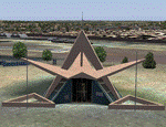
A photoreal Gmax representation of the SAAF Memorial on the hill just north of Swartkop AFB in Pretoria, South Africa. This file is meant to be used with the Aeroworx Swartkop AFB package installed (details in readme) but will also work with the default scenery.
| Filename: | South_African_Air_Force_Memorial__Pretoria_South_A.zip |
| License: | Freeware, limited distribution |
| Added: | 14th September 2012, 10:37:39 |
| Downloads: | 601 |
| Author: | Kobus van Wyk |
| Size: | 6.8 MB |
© 2001-2026 AVSIM Online
All Rights Reserved
Privacy Policy |