
Where Flight Simulation Enthusiasts Gather from Around the World!
AVSIM Library - Search Results

| Category: Flight Simulator 2004 - Scenery | |
| Colorado Hops by LBMartin |

|
File Description:
For helicopter lovers. In this scenery you will find several spots around Denver, CO. Updated Jeffco airport ("Rotors of the Rockies" hangars, new control tower, new main building, Fire station, McCair building, R22 School...), helipads in some airports in the near area, S&R Base, "The Fort" Restaurant, "Manor House" Restaurant, Mountain Resort, Swedish Medical Center, North Suburban Medical Center, St Anthony North Hospital...
| Filename: | Colorado_Hops_by_LBMartin.zip |
| License: | Freeware, limited distribution |
| Added: | 25th November 2005, 23:05:57 |
| Downloads: | 1,394 |
| Author: | Martin Lopez a.k.a. LBMartin |
| Size: | 10.46 MB |
| Category: Flight Simulator 2004 - Scenery | |
| Real Landclass of Dublin Airport and surrounding area incl. the town of Swords |
|
File Description:
In FS2004 the default Landclass of Dublin Airport and it's surrounding area is not the same as in reality.
In FS2004 the Airport is surrounded by residential areas in the south, southwest and southeast and with dry grass land in the north, northwest and northeast. Also the town of Swords (in the north of Dublin Airport) is not included as well as
some golfing areas.
With this file you will get a more realistic landclass of Dublin Aiport and it's surrounding area. As in reality the airport is surrounded by farmingfields and corplands as well as some golfing areas and most important the town of Swords in the north.
| Filename: | Real_Landclass_of_Dublin_Airport_and_surrounding_a.zip |
| License: | Freeware |
| Added: | 2nd July 2008, 15:30:41 |
| Downloads: | 2,849 |
| Author: | Dave Sheffield |
| Size: | 13.94 KB |
| Category: Flight Simulator 2004 - Scenery | |
| Catalina Airport (KAVX) |
|
File Description:
This file enhances Catalina Airport (KAVX) while still maintaining high framerates. It includes a custom Afcad2 file as well as scenery objects at the airport. Santa Catalina is a small island just off the coast of Southern California. The small Catalina airport is a difficult but picturesque approach.
| Filename: | Catalina_Airport_KAVX.zip |
| License: | Freeware, limited distribution |
| Added: | 27th February 2006, 00:51:57 |
| Downloads: | 2,948 |
| Author: | Craig Swartzlander |
| Size: | 128.92 KB |
| Category: Flight Simulator 2004 - Scenery | |
| FSFlightline FSE Vol. 2 - Apex Aipark (WA05) & Olympic Airfield (WA45) |
|
File Description:
The second installment of my series of Washington State airports sceneries for use with Lago's FS Enhancer. This volume features Apex Airpark in Silverdale, WA and Olympic Airfield in Discovery Bay, WA. Both are fictional representations and feature static and dynamic scenery including moving cars, highway traffic, ambient sounds, and dynamic wildlife. Fly over the Hood Canal and look for the subs leaving Subase Bangor. Includes custom AFCADs for both airfields. Requires Lago's FS Enhancer to function.
| Filename: | FSFlightline_FSE_Vol_2___Apex_Aipark_WA05__Olympic.zip |
| License: | Freeware |
| Added: | 7th February 2004, 22:16:40 |
| Downloads: | 1,063 |
| Author: | Jeff Shields |
| Size: | 482.04 KB |
| Category: Flight Simulator 2004 - Scenery | |
| Elevation Fix For Addon KBUR KDCA KSNA Airport Scenery |
|
File Description:
This file includes three small BGL files designed to be used with one or more of the following addon airport scenery files developed by Shehryar 'Shez' Ansari:
BUR2005.zip for KBUR Burbank / Bob Hope; dca2002.zip for KDCA Reagan National / Washington DC; and SNA2004.zip for KSNA John Wayne / Santa Ana.
These BGL files set the FS9 airport elevations allowing AFCAD files to work properly with this scenery. More info on how and why in the included readme.
| Filename: | Elevation_Fix_For_Addon_KBUR_KDCA_KSNA_Airport_Sce.zip |
| License: | Freeware |
| Added: | 22nd November 2005, 00:34:29 |
| Downloads: | 9,484 |
| Author: | Scott Smart |
| Size: | 5.21 KB |
| Category: Flight Simulator 2004 - Scenery | |
| Györ-Pér (LHPR) Photoreal Scenery, Hungary |
|
File Description:
This is Györ-Pér, located further north of the lake Balaton.
The asphalt runway was opened in 2003.
It is an open international, public airport.
| Filename: | GyrPr_LHPR_Photoreal_Scenery_Hungary.zip |
| License: | Freeware |
| Added: | 17th July 2004, 23:34:01 |
| Downloads: | 2,220 |
| Author: | Tamás Várhegyi, László Horváth |
| Size: | 1.76 MB |
| Category: Flight Simulator 2004 - Scenery | |
| St. George (KSGU) / Mesquite (67L), Utah/Nevada, Photo-Scenery (FS9 & FSX) |
|
Images related to this file:
File Description:
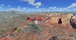
Covers the area between St. George, Utah and Mesquite, Nevada. To the north of St. George
the Pine Valley Mountains with their foothills of scenic red sandstone loom over the city.
St. George Municipal Airport (KSGU) is mostly used for general aviation but is also served by SkyWest Airlines
on behalf of Delta Connection. Because of it's location on a mesa this airport can't be expanded and so a new
airport is currently being built southeast of the city at the site of an abandoned airfield. The opening
is expected in 2011. To the south of the city make sure, you don't miss the Virgin River Gorge where the
Virgin River winds thru a long winding canyon in the transition zone between the red rocks of southern Utahs
Colorado Plateau and Nevadas Mojave Desert. Shortly afterwards you reach Mesquite which is situated just
west of the Arizona stateline. Like nearly all Nevada cities near the stateline Mesquite is home to several
Casinos. Mesquite Airport (67L) lies just north of the city.
High resolution versions of this scenery for FS9 and FSX (much sharper, but larger and multiple downloads)
are available at www.blueskyscenery.com/CNY_South3West6.html . The screenies are taken from the high-res versions,
so expect this version to be slightly more blurry. Thanks to Joop Mak for providing custom AFCADs that
correct airport layouts so that they align with the photo-textures! They are available at www.blueskyscenery.com/AFCADs.html .
YourDonation@Work: Dedicated to Werner, Ralf-Peter and Nels.
| Filename: | St_George_KSGU__Mesquite_67L_UtahNevada_PhotoScene.zip |
| License: | Freeware, limited distribution |
| Added: | 24th March 2010, 19:41:43 |
| Downloads: | 1,649 |
| Author: | Gottfried Razek - blueskyscenery.com |
| Size: | 95.58 MB |
| Category: Flight Simulator 2004 - Scenery | |
| Arviat CYEK in Nunavut, Canada |
|
Images related to this file:
File Description:
Arviat is a small town on the west coast of Hudson Bay in Nunavut, around 90 miles south of Whale Cove, 130 miles south of Rankin Inlet, and 160 miles north of Churchill. The airfield is just south of the town, and the 4,000 feet of gravel runway is aligned 149T/329T; these are true bearings and not magnetic as Arviat is just inside the Northern Domestic Airspace zone. There is 100LL fuel available in drums, with 2 hours prior notice. The visiting AI airline is Calm Air, plus a cargo delivery by Buffalo Air. As a town of 2,200 people is too large to model I have used a landclass with autogeneration. The result includes some trees, which is not realistic, but there was no way out. There is a special note in the instructions regarding Flight Ontario replacement textures and "glowing" gravel aprons.
| Filename: | Arviat_CYEK_in_Nunavut_Canada.zip |
| License: | Freeware, limited distribution |
| Added: | 6th January 2012, 16:13:45 |
| Downloads: | 506 |
| Author: | Roger Wensley |
| Size: | 2.19 MB |
| Category: Flight Simulator 2004 - Scenery | |
| Kangiqsujuaq CYKF in northern Quebec, Canada |
|
Images related to this file:
File Description:
Kangiqsujuaq is on the north coast of Quebec, 85 miles west of Quaqtaq and 125 miles east of Salluit, while across the Hudson Strait and 100 miles away on Baffin Island is Kimmirut. The town grew around two trading posts, the first opened by Revillon Freres in 1910, and the second by the Hudson Bay Company in 1914. A school was opened in 1960, and a clinic in 1961. The town was known as Wakeham Bay until 1961, and now has a population of around 700. The airport is to the south of the town and up on the hill at 511 feet ASL (this has been remeasured since 2004 and is now known to be 501). The gravel runway is just over 3,500 feet long and aligned 15/33; there is no PAPI, but there is fuel available, both 100LL and JetA. There are flights by Air Inuit.
| Filename: | Kangiqsujuaq_CYKF_in_northern_Quebec_Canada.zip |
| License: | Freeware, limited distribution |
| Added: | 27th January 2013, 00:55:00 |
| Downloads: | 231 |
| Author: | Roger Wensley |
| Size: | 2.31 MB |
| Category: Flight Simulator 2004 - Scenery | |
| Churchill Falls CZUM in Newfoundland and Labrador Canada |
|
Images related to this file:
File Description:
Churchill Falls is a small town on the Churchill River, around 230 miles north of the Gulf of St Lawrence coast and 120 miles east of Labrador City. It is a company-built town for the staff and families that work in the generating station associated with the falls. The falls were first discovered in the 1830's and work on the generating station commenced in 1967. The runway is 5,500 feet of asphalt aligned 13-31, with PAPI and approach lighting at both ends, and the apron at the eastern end. The buildings are well replicated here and the AI includes both GA flights and the daily flights by Provincial Airways, along with a medical transport service. There is a dock for float planes on a nearby lake that is no longer in regular use and officially listed as closed, but the dock remains there and is included here.
| Filename: | Churchill_Falls_CZUM_in_Newfoundland_and_Labrador_.zip |
| License: | Freeware, limited distribution |
| Added: | 25th August 2020, 18:16:40 |
| Downloads: | 179 |
| Author: | Roger Wensley |
| Size: | 11.92 MB |
© 2001-2026 AVSIM Online
All Rights Reserved
Privacy Policy |