
Where Flight Simulation Enthusiasts Gather from Around the World!
AVSIM Library - Search Results

| Category: Flight Simulator 2004 - Scenery | |
| City of Greensboro, North Carolina |

|
File Description:
This Add-on includes Greensboro city.
| Filename: | City_of_Greensboro_North_Carolina.zip |
| License: | Freeware |
| Added: | 23rd August 2003, 18:01:55 |
| Downloads: | 3,225 |
| Author: | Toni Hiltunen |
| Size: | 313.28 KB |
| Category: Flight Simulator 2004 - Scenery | |
| North Atlantic Ocean International airport - |
|
File Description:
NAOI is a fictional airport in the middle of the Atlantic Ocean. Wouldn't it be nice to land and refuel when you are crossing the pond? Well I made an airport for you, hope you like it and enjoy.
| Filename: | North_Atlantic_Ocean_International_airport_.zip |
| License: | Freeware |
| Added: | 11th December 2008, 16:44:02 |
| Downloads: | 326 |
| Author: | Jose Ramos Ruiz |
| Size: | 453.94 KB |
| Category: Flight Simulator 2004 - Scenery | |
| Airstrips of North-East Germany |
|
Images related to this file:
File Description:
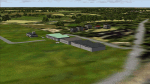
Moving towards completing my Airstrips of Western Europe project, herewith 50+ sceneries for smaller airfields in NE Germany, that I haven't included in my previous uploads, each enhanced with taxiways, parking spaces, buildings etc. and aprons as appropriate, to further facilitate the generation of lightweight AI traffic in the area, without overloading the more major airfields. If you have my "German Airstrips" folder from my previous uploads, these are in addition to that and the folders can be merged. Any apparent duplicates will be (minor) updates and can be over-written.
Again, there's no photo-realism here, just a selection of basic 'generic' buildings, more or less accurately sized and placed to reflect the airfield layout as seen on on-line satellite imagery and aerial photography. These buildings have minimal effect on frame-rates, so are ideal for this kind of job. The airfields are aligned as well as possible with the roads etc. in UT Europe and the Genesis Europe mesh, but should mostly be fine in a default installation or other configuration.
As before, the files for each airfield can be easily identified by the ICAO code, even if the airfield names vary slightly, so you can pick and choose and mix and match to suit any sceneries you already have, should you so wish. There is no requirement for any other download. Each airfield will exist as a stand-alone entity should you only want a few of them.
Very few basic library objects are used ... you can add "eye-candy" to suit your own taste should you wish, or just leave them as vague shapes in the scenery that can put a few more small aircraft into the air. As with other airfields in this series, now these are "ai-activated" you can expect to see the occasional little aircraft turn up at some of them if you've got any third-party traffic installed.
Please read the rest of this "blurb" in the enclosed text file ... there may be some details of interest.
| Filename: | Airstrips_of_NorthEast_Germany.zip |
| License: | Freeware |
| Added: | 14th April 2025, 19:55:20 |
| Downloads: | 76 |
| Author: | Chris Eve |
| Size: | 2.11 MB |
| Category: Flight Simulator 2004 - Scenery | |
| North American Winter Season replacement |
|
File Description:
This scenery addon replaces the default "hard winter" texture coverage maps for North America. The maps determine, on a monthly basis, where snow-covered textures appear in Flight Sim 9. In general, there will be more snow in this replacement. Note that the coverage maps change about the 19th of each calendar month in FS9. Also because of the resolution of the maps in FS9, it is impossible to use this technique to correct small scenery areas, such as mountain peaks. This file extends and replaces my previous Blizzard-06! scenery.
| Filename: | North_American_Winter_Season_replacement.zip |
| License: | Freeware |
| Added: | 6th December 2006, 10:49:23 |
| Downloads: | 1,947 |
| Author: | Scott Smart |
| Size: | 424.31 KB |
| Category: Flight Simulator 2004 - Scenery | |
| Airstrips of North-West Europe |
|
Images related to this file:
File Description:
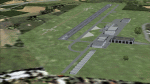
The sales blurb for FS2004 announced the inclusion of over 23,000 airfields ... unfortunately a significant number of those consisted of little or nothing more than a runway on a flatten with a rectangular background polygon.
To enable the addition of an amount of lightweight GA AI traffic, without overloading those airfields that were designed with parking spaces and taxi-ways, (and are probably already busy), I herewith include over 140 small sceneries, of mostly default airfields, from NW France, up the English Channel and the North Sea coast through Belgium, the Netherlands and NW Germany to Denmark, all with added taxiways and parking spots, aprons, generic buildings and background polygons as appropriate, to enable AI traffic to be generated without interrupting things at the more major airports.
A few of the French airfields are "new", not included originally with FS2004, and a couple have been updated to suit more recent developments :- for example, LFES "Scaer Guiscriff" is now LFES "Bretagne Atlantique", LFOR "Chartres Champhol" is now LFOR "Chartres Metropole", EHSE "Seppe" is now EHSE "Breda International" and EKVH "Vesthimmerlands" was previously EKVH "Aars".
There's no photo-realism here, just a selection of basic 'generic' buildings, more or less accurately sized and placed to reflect the airfield layout as seen on on-line satellite imagery and aerial photography. These buildings have minimal effect on frame-rates, so are ideal for this kind of job.
The airfields are aligned as well as possible with the roads etc. in UT Europe and the Genesis Europe mesh, but should mostly be fine in a default installation or other configuration.
Please read the rest of this "waffle" in the included text file ... it might save some confusion ;)
Enjoy :)
| Filename: | Airstrips_of_NorthWest_Europe.zip |
| License: | Freeware |
| Added: | 14th June 2024, 13:44:58 |
| Downloads: | 283 |
| Author: | Chris Eve |
| Size: | 9.95 MB |
| Category: Flight Simulator 2004 - Scenery | |
| Bakdusan Aero (R007) Version 0.2 |
|
File Description:
Beakdusan Aero located top of the Beakdu Mountain(North Korea). This version added 2 gates and 8 parking area.
| Filename: | Bakdusan_Aero_R007_Version_02.zip |
| License: | Freeware |
| Added: | 25th July 2004, 02:00:10 |
| Downloads: | 1,086 |
| Author: | Hyun Pil Kim |
| Size: | 105.34 KB |
| Category: Flight Simulator 2004 - Scenery | |
| LIPP - CaSavio HeliBase |
|
File Description:
LIPP Helifield situated 2nm north of LIPV(Lido di Venezia airfield). Requires Lago FSE. Suitable for Helicopter ops only.
| Filename: | LIPP__CaSavio_HeliBase.zip |
| License: | Freeware |
| Added: | 11th August 2005, 17:54:06 |
| Downloads: | 477 |
| Author: | Emanuele Rastelli |
| Size: | 1.3 MB |
| Category: Flight Simulator 2004 - Scenery | |
| FS2004 Menai Suspension Bridge Project scenery. |
|
File Description:
This scenery depicts the world famous Thomas Telford Menai Suspension Bridge that Links Anglesey to the North Wales mainland.
| Filename: | FS2004_Menai_Suspension_Bridge_Project_scenery.zip |
| License: | Freeware |
| Added: | 6th December 2005, 00:15:39 |
| Downloads: | 1,910 |
| Author: | Dyl Roberts |
| Size: | 1.54 MB |
| Category: Flight Simulator 2004 - Scenery | |
| Hells Canyon, Oregon / Idaho SRTM30_1ArcSec Terrain Mesh |
|
File Description:
This 38m terrain mesh is centered in Hells Canyon of the Snake River
between Oregon and Idaho. Coverage area: From West 116.2° to West 117.1°
and North 45.0° to North 46.5°. It includes the City of Lewiston,
Hells Canyon National Recreation Area with Snake and Imnaha River,
Salmon River and the Seven Devils mountain peaks.
| Filename: | Hells_Canyon_Oregon__Idaho_SRTM30_1ArcSec_Terrain_.zip |
| License: | Freeware, limited distribution |
| Added: | 29th December 2003, 16:58:59 |
| Downloads: | 3,025 |
| Author: | Andreas Trawny |
| Size: | 6.16 MB |
| Category: Flight Simulator 2004 - Scenery | |
| Jamaica Replacement Landclass |
|
File Description:
This landclass features accurate layout of cities like Kingston, Montego Bay and Spanish Town.
Vegetation has been vastly improved to depict forest, sugar cane and drier areas like the SW coast.
I have tried to include almost every town and village in the interior.
| Filename: | Jamaica_Replacement_Landclass.zip |
| License: | Freeware |
| Added: | 31st May 2004, 13:16:52 |
| Downloads: | 6,325 |
| Author: | Patrick Bergamasco |
| Size: | 3.22 KB |
© 2001-2026 AVSIM Online
All Rights Reserved
Privacy Policy |