
Where Flight Simulation Enthusiasts Gather from Around the World!
AVSIM Library - Search Results

| Category: Flight Simulator 2004 - Scenery | |
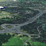
| Ivujivik CYIK and Quaqtaq CYHA adapted for the FSGenesis 76m North Canada Terrain Mesh |

|
Images related to this file:
File Description:
These are replacement bgl's to convert Ivujivik CYIK and Quaqtaq CYHA in Quebec Canada for use with the FSGenesis 76m terrain mesh for northern Canada. I recently discovered this terrain mesh while making a scenery that is, in real life, on the edge of a cliff and cannot understand now why I did not install it before. This is not stand-alone, and presumes that you have already downloaded and installed both previously posted sceneries. The installation consists solely of replacing the existing scenery bgl's with the new. Ivujivik has built a new terminal building since the original scenery post but I have fond "Summer" memories of the old one and stayed with it, shown here in a pic at a surprising time of the year.
| Filename: | Ivujivik_CYIK_and_Quaqtaq_CYHA_adapted_for_the_FSG.zip |
| License: | Freeware, limited distribution |
| Added: | 26th August 2017, 17:54:09 |
| Downloads: | 92 |
| Author: | Roger Wensley |
| Size: | 1.94 MB |
| Category: Flight Simulator 2004 - Scenery | |
| Rockcliffe Flying Club update for the Flight Ontario Rockcliffe CYRO scenery in Ontario, Canada |
|
Images related to this file:
File Description:
I recently installed a new mesh and discovered that some of my sceneries needed some modifications; CYRO Rockcliffe is one of them. Some of you may have the same problem at the east end of the airfield. This version takes care of changes that any add-on mesh may make by getting the land flat where it needs to be for the fences, the access road on the edge of the flat where it is in real life, and makes the best that can be made of the yacht club access ramp (unfortunately it is very difficult to manage elevation changes within FS9). Even if you have the default FS9 mesh this should still work ok. As I was anyway posting this I added night textures for the new clubhouse.
| Filename: | Rockcliffe_Flying_Club_update_for_the_Flight_Ontar.zip |
| License: | Freeware, limited distribution |
| Added: | 16th July 2010, 00:32:22 |
| Downloads: | 328 |
| Author: | Roger Wensley |
| Size: | 842.78 KB |
| Category: Flight Simulator 2004 - Scenery | |
| Rockcliffe Flying Club modifications for the Flight Ontario Rockcliffe CYRO scenery in Ontario, Canada |
|
Images related to this file:
File Description:
Flight Ontario posted their scenery for Rockcliffe CYRO in 2008, having worked with all the information they had but not all the information they would have liked (the usual situation with all scenery designers, including me). I learnt to fly at RFC and know Rockcliffe well so there are some additions and modifications here including the refueling point near the RFC buildings, revised apron shape, gravel car park, parked cars, extended perimeter fence, deck in front of the RFC clubhouse, more parked planes, the large and old willow tree, and the float dock in the river. Of course, since then the willow tree was felled by a tornado and there are now other major modifications including a new hangar, so watch this space.
| Filename: | Rockcliffe_Flying_Club_modifications_for_the_Fligh.zip |
| License: | Freeware, limited distribution |
| Added: | 7th February 2010, 13:55:27 |
| Downloads: | 443 |
| Author: | Roger Wensley |
| Size: | 1.17 MB |
| Category: Flight Simulator 2004 - Scenery | |
| YEVD Evans Head Memorial, Australia |
|
File Description:
Googly scenery for YEVD Evans Head Memorial, a former RAAF Training base in
New South Wales, Australia, now reduced to a single runway and small apron.
In its heyday it was home to the RAAF No 1 Bombing and Gunnery and the RAAF No 1
Air Observers Schools and it was said to be the largest training base in the
southern hemisphere - at that time it had four runways.
Flight Simulator 2004 has made no provision for traffic with only a runway
provided and this scenery seeks to redress the situation so that you and your
"AI" traffic can use the airport.
The scenery does not purport to be ultra-accurate. Based on high quality
satellite imagery from Google Earth, the layout is proportionally correct but the
added airport features, such as buildings, are built from default Microsoft objects
and add-on libraries so will not look exactly like the real thing.
You are not obliged to download and install any additional scenery libraries,
but to enjoy this scenery in its entirety, you may wish to. It will work fine,
with or without.
| Filename: | YEVD_Evans_Head_Memorial_Australia.zip |
| License: | Freeware |
| Added: | 19th April 2008, 10:23:02 |
| Downloads: | 544 |
| Author: | John Hinson |
| Size: | 71.78 KB |
| Category: Flight Simulator 2004 - Scenery | |
| OSM World: Western Europe |
|
Images related to this file:
File Description:
Read Installation instructions carefully, this is a complex scenery package!
This package includes a "Dev Kit" should you wish to expand it to other areas! Please contact me if you wish to do so! This is community effort! If we all contribute, we will hopefully have the entire world covered one day!
Welcome to OSM World: Western Europe! This is a vector data scenery package covering the western European area. Coastlines, Rivers, lakes, roads, railways, and power lines with detail never before seen! All in an autogen-compatible density! You can see roundabouts, train terminals, harbor areas in a resolution of a point every 10 meters. At this same resolution a vectorial city class places residential (in small and big building variations, depending on surface area) and industrial areas exactly where they are supposed to be. This gives the city areas a resolution far superior to the capacity of FS-2004 default landclass bitmaps, limited to approximately 1 Km x 1 Km squares. OSM World: Western Europe will even give you small roads leading to small towns (even a few houses across)! From big highway intersections, including ramps, to the tiniest rural pathways covering the entire western area! Wherever in Western Europe you fly, there is something to see!
| Filename: | OSM_World_Western_Europe.zip |
| License: | Freeware |
| Added: | 13th October 2014, 00:18:39 |
| Downloads: | 4,130 |
| Author: | Mario Noriega |
| Size: | 274.75 MB |
| Category: Flight Simulator 2004 - Scenery | |
| VVCR Cam Ranh Airport |
|
Images related to this file:
File Description:

Cam Ranh is currently a fast-growing beauty spot and tourist area on the Vietnamese coast. In May 2004, Cam Ranh airport (VVCR) opened to commercial traffic, initially only serving domestic traffic but international flights will commence in 2005. The airport was once a massive US Air Force base, but was later used as a base for Russion spy plane activities.
This scenery adds this "missing" airport to Flight Simulator, but much is based around satellite views of the airport when the US were spying on the Russian base and other historical information and it may not accurately reflect the airport as it is today. Furthermore, my capabilities at scenery design are limited and restricted to scenery objects available through the Rwy12 scenery creation programme.
You do NOT need to download and install the full 45 MB Rwy 12 Object Placer programme, which is for the designers and not the end user.
Some of the scenery objects will appear without any extra downloads, but to get the greatest benefit from this scenery, you may optionally download following files, which should be installed according to the instructions within this download and not as described in their own download archive:
Level 2 objects
rwy12-lvl2.zip (Israel Roth and Seev Kahn/John Hinson),
Level 3 objects
jw_rwy12.zip (Shehryar Ansari),
tl_rwy12.zip (Todd Lucas) ,
ford_transit_collection.zip (S Legg),
hgrrwy12.zip (ESDG), and
ga-hangers_lib_for_rwy12.zip (S Legg)
Also included with this scenery are two EditVoicepack files which may be imported to that programme so that the controllers will be heard referring to "Cam Ranh".
[File re-uploaded at request of AVSIM] See also file vvcru11.zip.
| Filename: | VVCR_Cam_Ranh_Airport.zip |
| License: | Freeware |
| Added: | 15th May 2010, 01:13:46 |
| Downloads: | 4,168 |
| Author: | John Hinson |
| Size: | 21.36 KB |
| Category: Flight Simulator 2004 - Scenery | |
| Frozen rivers and lakes for winter ski operations along the Canada/USA border and Alaska |
|
Images related to this file:
File Description:
This "freezes" lakes and rivers in a wide strip along both sides of the Canadian and US border and part of Alaska (and is reversible with a tick in the FS9 library) and can be landed on with skis or wheels for winter operations. The area covered is from east of Quebec City to west of Calgary and Edmonton, with an extension north to cover Hudson Bay, so from from 70 west to 100 west and 40 north to 56 north (65 north in the Hudson Bay area). This includes large parts of Quebec, Ontario, Manitoba, Saskatchewan, Alberta, Michigan, Wisconsin, and Minnesota, and most of North Dakota and Montana, and the Alaska north shore and around Anchorage.
This is really for use with Ultimate Terrain, though it will work without it. But as UT is what gets all the lakes and rivers there and in the right place it would be a shame not to be using UT.
| Filename: | Frozen_rivers_and_lakes_for__winter_ski_operations.zip |
| License: | Freeware, limited distribution |
| Added: | 18th February 2010, 14:33:41 |
| Downloads: | 628 |
| Author: | Roger Wensley |
| Size: | 424.36 KB |
| Category: Flight Simulator 2004 - Scenery | |
| High-resolution 76-m (LOD9) Terrain Mesh and Scenery Enhancements for the Southern Canadian Rockies |
|
File Description:
Not simply an add-on mesh, these files include many scenery enhancements for the southern Rockies of British Columbia and Alberta. Coverage extends from Cranbrook to Calgary, and Hinton to Edmonton (N48.9-53.4 W112.3-116.3). The mesh source data are 3-arcsec (~90-m) Shuttle Radar (SRTM) files, compiled at LOD9 (76-m) resolution. All lake elevations (!) have been adjusted to eliminate the problems with the default lake data and to better fit the new terrain mesh. In addition, the Transcanada Highway/Icefields Parkway corridor in Banff National Park, from Canmore to the Hwy 11 junction, has been completely re-made, with dozens of alpine lakes (including Lake Louise, Moraine Lake, and Lake O'Hara), accurate transportation network, and landclass/waterclass updates based on satellite imagery. Due to significant changes in FS2004 to vector layering and autogen features, the special scenery enhancements cannot be used with FS2002. However, terrain mesh, lake corrections and landclass replacements will work well in FS2002.
| Filename: | Highresolution_76m_LOD9_Terrain_Mesh_and_Scenery_E.zip |
| License: | Freeware, limited distribution |
| Added: | 29th October 2003, 03:01:22 |
| Downloads: | 15,464 |
| Author: | Holger Sandmann |
| Size: | 21.81 MB |
| Category: Flight Simulator 2004 - Scenery | |
| Kivitoo, Paulatuk, Qikiqtarjuak, Rowley Island, & West Baffin, adapted for FSGenesis 76m North Canada Terrain Mesh |
|
Images related to this file:
File Description:
These are replacement bgl's to convert five northern Canada fields for use with the FSGenesis 76m terrain mesh for northern Canada. The five are Kivitoo CWFK, Paulatuk CYPC, Qikiqtarjuak CYVM, Rowley Island CWFR, and West Baffin CWFW. These are not stand-alone, and the presumption is that you have already downloaded and installed the previously posted sceneries. This installation consists solely of replacing the existing scenery bgl's with the new. This is the last post of adapted northern airfields (unless more are discovered needing revision) and observations regarding and any further corrections that are required would be welcomed.
| Filename: | Kivitoo_Paulatuk_Qikiqtarjuak_Rowley_Island__West_.zip |
| License: | Freeware, limited distribution |
| Added: | 18th September 2017, 22:28:33 |
| Downloads: | 87 |
| Author: | Roger Wensley |
| Size: | 3.02 MB |
| Category: Flight Simulator 2004 - Scenery | |
| WAML Palu/Mutiara, Indonesia |
|
Images related to this file:
File Description:
Googly scenery for WAML Palu/Mutiara, Indonesia. In Flight Simulator 2004 little
is provided other than a runway at this small domestic airport, although in the
real world it sees regular jet flights from airlines such as Batavia Air, Bouraq
Indonesia Airlines, Garuda Citylink, Lion Airlines and Merpati Nusentara and
smaller aircraft from operators like Airfast Service and Indonesia Air Transport.
These scenery files add aprons, taxiways, buildings and other airport features
to Flight Simulator's limited representation and allow "AI" traffic to land,
taxi, park and take off in a realistic manner.
The scenery does not purport to be ultra-accurate. Based on high-detail satellite
imagery from Google Earth, the layout is proportionally correct but the added
airport features, such as buildings, are built from default Microsoft objects
and add-on libraries so will not look exactly like the real thing.
You are not obliged to download and install any additional scenery libraries,
but to enjoy this scenery in its entirety, you may wish to. It will work fine,
with or without.
| Filename: | WAML_PaluMutiara_Indonesia.zip |
| License: | Freeware |
| Added: | 15th May 2010, 01:11:30 |
| Downloads: | 1,770 |
| Author: | John Hinson |
| Size: | 140.88 KB |
© 2001-2026 AVSIM Online
All Rights Reserved
Privacy Policy |