
Where Flight Simulation Enthusiasts Gather from Around the World!
AVSIM Library - Search Results

| Category: Flight Simulator 2004 - Scenery | |
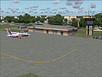
| Ohio Islands - 3W9 Bass Isle |

|
File Description:
Microsoft Flight Simulator 2004 Scenery - Ohio Islands 3W9
Middle Bass Island - East Point, a general aviation airfield in northern Ohio located in Lake Michigan. Extensively reworked. Features FSDSv2 custom-built hangers and objects in high detail, VTP2 coded ground textures and a detailed airport with full seasonal changes and Autogen support. Includes an amphibious landing area and detailed, animated dock that rises and falls with the tidal swells. Custom lighting throughout. Opening/closing hangar doors. Includes full documentation and map. All required files and textures included. Optimized for FS2004. Created specifically to allow users to adjust frame rates through the use of the Scenery Density/Autogen sliders for increasing levels of detail and realism.
| Filename: | Ohio_Islands__3W9_Bass_Isle.zip |
| License: | Freeware |
| Added: | 12th September 2003, 00:34:28 |
| Downloads: | 2,518 |
| Author: | Mark Smith |
| Size: | 4.37 MB |
| Category: Flight Simulator 2004 - Scenery | |
| My Water Project V1.1 |
|
Images related to this file:
File Description:

There is no texture change between V1.0 and V1.1, just the new installation program.
This is my first EXE. hope it will be good !
My water Project V-1.1 is a freeware add-on that replaces the sad water textures of Flight Simulator 2004.
My water Project V-1.1 - replaces the sea and ocean coral blue with a more realistic blue
- adds wonderful coral waters
- adds a pumping effect
- colors change with the time of day
- includes a great sun reflection effect and slightly the clouds
This is my first EXE installator. Hope you will like it...
| Filename: | My_Water_Project_V11.zip |
| License: | Freeware, limited distribution |
| Added: | 11th December 2009, 16:36:49 |
| Downloads: | 2,672 |
| Author: | AirTimSimulation" |
| Size: | 12.94 MB |
| Category: Flight Simulator 2004 - Scenery | |
| Inchon Intl Airport (RKSI) 'The Winged City' v1.0 |
|
File Description:
FS2002/2004 Inchon Intl Airport scenery "the Winged City" v1.0 is the most realistic freeware scenery of Inchon Intl Airport (RKSI) in Korea. RKSI is the largest airport in Korea and ranked sixth airport in handling cargo(2002). Also it is the first airport in Asia to earn the rating of the ILS CAT III-b operation.(Sep, 03) In my scenery there are... * Two runways (15R/33L, 15L, 33R) and VOR, ILS * Passenger Terminal and Cargo and Maintenance ramp, Taxiway * Control tower and 44 gates with boarding bridge * Shoreline of Yeongjong Island, Yongyu Island and around Islands and SRTM 3 arc-sec mesh scenery data around the airport.
| Filename: | Inchon_Intl_Airport_RKSI_The_Winged_City_v10.zip |
| License: | Freeware |
| Added: | 22nd February 2004, 21:31:29 |
| Downloads: | 91,340 |
| Author: | Yunjin Lee |
| Size: | 14.73 MB |
| Category: Flight Simulator 2004 - Scenery | |
| Phoenix Deer Valley Airport |
|
File Description:
FS2004 Scenery-Phoenix Deer Valley Municipal Airport (KDVT) serves Phoenix and Maricopa County and is owned by the City Of Phoenix. The airport has more than one runway. The longest is a paved runway extending 8200 feet. The facility is at an elevation of 1476 feet at a distance of about 15 miles from Phoenix. Phoenix Deer Valley Airport is a general aviation reliever airport for Phoenix Sky Harbor International Airport. The airport is home to more than 1,350 based aircraft and had more than 340,000 takeoffs and landings in 2004. A vital component of the City of Phoenix airport system, Deer Valley is the second busiest general aviation airport in the nation. Scenery created with FSDS2, Rwy12, Lago's FSE, with AFCAD2 and Traffic Tools. Contains 438 parking spaces.
| Filename: | Phoenix_Deer_Valley_Airport.zip |
| License: | Freeware |
| Added: | 23rd September 2005, 20:33:47 |
| Downloads: | 2,011 |
| Author: | John B. Loney, Jr. |
| Size: | 1.46 MB |
| Category: Flight Simulator 2004 - Scenery | |
| DGSI Kumasi, Ghana |
|
Images related to this file:
File Description:
Googly scenery for Kumasi - a small domestic airport in Ghana for which no facilities
are provided in Flight Simulator 2004. These scenery files add taxiways, aprons,
buildings and other airport features, so that you and your "AI" traffic can land,
taxi, park and take off in a realistic manner.
The airport serves the city of Kumasi (capital of the Ashanti region) and sees
regular flights using turboprop airliners operated by Accra based operators
Antrak Air and Citylink.
The scenery does not purport to be ultra-accurate. Based on high-detail satellite
imagery from Google Earth, the layout is proportionally correct but the added
airport features, such as buildings, are built from default Microsoft objects
and add-on libraries so will not look like the real thing.
[File re-uploaded at request of AVSIM]
| Filename: | DGSI_Kumasi_Ghana.zip |
| License: | Freeware |
| Added: | 23rd May 2010, 01:25:23 |
| Downloads: | 1,419 |
| Author: | John Hinson |
| Size: | 80.3 KB |
| Category: Flight Simulator 2004 - Scenery | |
| South West Islands, Japan and Taiwan Ver.3.0 |
|
Images related to this file:
File Description:
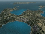
FS2004 Scenery SWIJT2004 Ver 3.0 (South West Islands, Japan and Taiwan)
These files improve specific scenerys (South West Islands of Japan and Taiwan, Asia) of FS2004. Included islands: Ohsumi Islands, Tokara Islands, Amami Islands, Okinawa lands, Kerama-Kume Islands, Miyako Islands, Yaeyama Islands and Taiwan Island.
In this scenery design, the coastline was reproduced as exactly as possible, following the specification of FS2004. Moreover, 90m mesh geographical data is reproduced by
using SRTM 3arc/sec. Correction of missing holes is perfect.
==NOTAM== I exhibited "SWIJ2k4.zip" on August 26, 2004.
However, it became clear that some of files of "SWIJ2k4" are infringing on the opyright of Microsoft. Then, I stopped public presentation of "SWIJ2k4". I apologize for having
made you trouble to those who already downloaded "SWIJ2k4.zip". New "SWIJT2k4.zip" is vast scenery which covered South West Islands, Japan and Taiwan Island. Please install new "SWIJT2k4".
By Kazuo Kawamura
| Filename: | South_West_Islands_Japan_and_Taiwan_Ver30.zip |
| License: | Freeware, limited distribution |
| Added: | 4th December 2011, 00:05:05 |
| Downloads: | 7,739 |
| Author: | Kazuo Kawamura |
| Size: | 20.5 MB |
| Category: Flight Simulator 2004 - Scenery | |
| USA West Mountain Landclass |
|
File Description:
The Landclass File is a stand alone scenery, you can use it with the FS Standart Scenery or other Landclass files like Cloud9, FS Genesis etc.
Now you will see rocky mountain Landclasses in the USA.
Green mountains are now past!! You get now the feeling to fly over high mountains and not over green hills.
The best results you get with FS Global or My World & Ground Enviroment(FS 2004 ) or Birds Eye View( FS2004 )
Installation:
Extract to the folder of FS2004 and activate the scenery in FS2004
| Filename: | USA_West_Mountain_Landclass.zip |
| License: | Freeware |
| Added: | 14th March 2008, 12:12:05 |
| Downloads: | 1,661 |
| Author: | Markus Balz |
| Size: | 176.54 KB |
| Category: Flight Simulator 2004 - Scenery | |
| Aasiaat BGAA on the west coast of Greenland |
|
Images related to this file:
File Description:
I wrote that Qikiqtarjuaq, on the east coast of Baffin Island, was the jumping off airfield for ferry flights for small planes from Canada to Europe via Greenland. Aasiaat is the airfield in Greenland that they jump to, 300 miles across the Davis Strait. The airfield is on the northern coast of Aasiaat Island, and the town of the same name is just two miles to the west. The runway is 2,600 feet of asphalt almost 100 feet wide and lit, at 74 feet ASL, aligned 12/30, with the apron and terminal building at the western end. Air Greenland run regular flights with a Dash-7 or 8, & Twin Otters, and the markings for the taxiway and parking spot in front of the terminal are exactly as they were six years ago. I have seen video since then that has further taxiway and parking spot markings added in, but I like the simplicity of the original. Unfortunately, given the limitations of FS and the single runway and simple taxiway routing there was no way to replicate both the parking facing away from the terminal AND the "through" taxiing to complete the circle back to the runway; after parking correctly the AI Air Greenland Dash-8 will reverse before heading out to take off. There is both JetA and 100LL fuel available. The surrounding area is rocky, and there is no grass around the runway; the airfield has compacted gravel instead.
| Filename: | Aasiaat_BGAA_on_the_west_coast_of_Greenland.zip |
| License: | Freeware, limited distribution |
| Added: | 26th March 2012, 11:01:16 |
| Downloads: | 690 |
| Author: | Roger Wensley |
| Size: | 2.73 MB |
| Category: Flight Simulator 2004 - Scenery | |
| VFR of Lario, Area A2 - Como lake, Italy |
|
Images related to this file:
File Description:
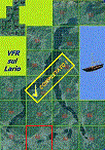
This is the seventeenth scenery, THE LAST ONE, of the "VFR of Lario" project.
This scenery covers approximately an area of 7.5x6 kmt, from the mountains over Albese con Cassano/Albavilla (NW) to Segrino small lake (NE), from Verzago/Alzate Brianza (SW) to Tabiago/Cibrone, Costa Masnaga (SE). Inside Verzago area is placed the AVL airport for gliders (LILB - Aeroclub Volovelistico Lariano).
Check video available here: http://youtu.be/r4h5PCVNMJM and https://youtu.be/huKdtYar_uQ
| Filename: | VFR_of_Lario_Area_A2__Como_lake_Italy.zip |
| License: | Freeware |
| Added: | 14th November 2013, 19:15:18 |
| Downloads: | 594 |
| Author: | Aldo Della Vedova, Daniele Lanfranchi, Gian Mario Verga |
| Size: | 16.66 MB |
| Category: Flight Simulator 2004 - Scenery | |
| VFR of Lario, Area A3 - Como lake, Italy |
|
Images related to this file:
File Description:
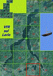
This scenery, 16th of the project, covers approximately an area of 7.5x6 kmt, from Corneno-Galliano-Carella-Mariaga (NW) to Valmadrera (NE), from Costa Masnaga (SW) to Colle Brianza, Nava (SE); specific buildings are included as overpasses of highway SS36 at inlet of Barro mountain and Cross at Cornizzolo mountain. Have nice flights on Como lake.
Check video available here: http://youtu.be/E4QB-HqlUt4
| Filename: | VFR_of_Lario_Area_A3__Como_lake_Italy.zip |
| License: | Freeware |
| Added: | 19th October 2013, 20:21:51 |
| Downloads: | 622 |
| Author: | Aldo Della Vedova, Daniele Lanfranchi, Gian Mario Verga |
| Size: | 12.47 MB |
© 2001-2026 AVSIM Online
All Rights Reserved
Privacy Policy |