
Where Flight Simulation Enthusiasts Gather from Around the World!
AVSIM Library - Search Results

| Category: Flight Simulator 2004 - Scenery | |
| TLPC - George F. L. Charles Airport - Saint Lucia |

|
Images related to this file:
File Description:
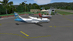
George F. L. Charles Airport IATA: SLU, ICAO: TLPC - is the smaller of two airports in Saint Lucia, the other being Hewanorra International Airport. It is located 2 km (1.2 mi) north of Castries, the capital city. George F. L. Charles Airport is managed by the Saint Lucia Air and Seaports Authority (SLASPA). Its runway runs parallel to a pristine beach, Vigie Beach, which is a popular tourist attraction.
| Filename: | TLPC__George_F_L_Charles_Airport__Saint_Lucia.zip |
| License: | Freeware |
| Added: | 25th August 2013, 21:18:44 |
| Downloads: | 1,311 |
| Author: | Delblond Christian |
| Size: | 9.6 MB |
| Category: Flight Simulator 2004 - Scenery | |
| UTOD Khorog Airport, Tajikistan |
|
File Description:
Khorog Airport (UTOD), Tajikistan.
Khorog Airport serves the city of Khorugh, (a city in the Gorno-Badakhshan Autonomous Province in Tajikistan). Due to difficult weather conditions, flights are cancelled frequently.
The airport resides at an elevation of 6,700 feet (2,042 m) above mean sea level. It has one runway designated 16/34 with an asphalt surface measuring 1,840 by 49 metres (6,037 ft × 161 ft).[1]
| Filename: | UTOD_Khorog_Airport_Tajikistan.zip |
| License: | Freeware |
| Added: | 25th April 2013, 21:12:40 |
| Downloads: | 408 |
| Author: | Billy Guo |
| Size: | 191.54 KB |
| Category: Flight Simulator 2004 - Scenery | |
| Unalakleet PAUN modification in Alaska |
|
Images related to this file:
File Description:
This version of Unalakleet PAUN is a modification of the scenery made by Sid and Pete way back in 2011, posted with Sid's knowledge and ok. There is a dearth of photographic information available on PAUN and it was only recently that there was enough so that hangars could be properly made and also properly situated. Which is why I made this now with a new ERA hangar, a new beige hangar rotated 90 degrees, next to it a blue hangar, plus fuel tanks, signage, and updated AI to include ERA planes, a NAC B737 and a NAC DC6B. Unalakleet has a population approaching 700, and lives by the income earned from the harvest from the sea and the river. There is no road within hundreds of miles and the only way to get food or anything else delivered is by ship (but only in the ice-free summer months) or through the airport.
| Filename: | Unalakleet_PAUN_modification_in_Alaska.zip |
| License: | Freeware, limited distribution |
| Added: | 24th July 2019, 18:55:37 |
| Downloads: | 245 |
| Author: | Roger Wensley |
| Size: | 3.94 MB |
| Category: Flight Simulator 2004 - Scenery | |
| Exploring Mt Rainier Natl Park v1.1 |
|
File Description:
Exploring Mt Rainier Natl Park v1.1
UPDATE! Includes missing textures which resulted in some users experiencing CTD and freezes. A complete remapping of Mount Rainier National Park in Washington State. Based upon commercial topographic maps, the designed scenery includes, every hiking trail drawn in meticulous detail including every real life switchback; every lake and small alpine pond 20 feet in diameter and over, modified landclass of alpine, forest & rock; every perennial and many intermittent creeks, all steams and rivers (many braided), a complete glacier mapping of every glacier with custom textures and ice fields on the mountain, a complete mapping of all rock faces and rock, moraine rock deposits, glacier outwash area, mudflows, roads, swamp and marsh areas. Includes some effects. Designed to compliment UT USA and any LOD 9 or 10 mesh. Works well with FS Genesis LOD 10 mesh and Birds Eye View Textures. By Bryan Wallis and Lou Frost.
| Filename: | Exploring_Mt_Rainier_Natl_Park_v11.zip |
| License: | Freeware, limited distribution |
| Added: | 18th February 2006, 23:14:40 |
| Downloads: | 4,149 |
| Author: | Bryan Wallis & Lou Frost |
| Size: | 11.61 MB |
| Category: Flight Simulator 2004 - Scenery | |
| Buffalo Narrows CYVT in Saskatchewan, Canada |
|
Images related to this file:
File Description:
Buffalo Narrows is a small town (around 1,400 folks) 130 miles west and a bit north of La Ronge in Saskatchewan, and I discovered that the Buffalo Narrows airfield, wrongly positioned in FS9, had been flooded out by Ultimate Terrain's lake; this is the rescue package. Actually that would be several lakes as the place is surrounded by water including Churchill Lake, Little Peter Pond Lake, and of course Big Peter Pond Lake.
There are two runways, the longest being 5,006' of 100' wide asphalt aligned 11/29, and the other 2,297 and 75' wide, also asphalt. Both runways are lit, and there is JetA and 100LL fuel available. I have placed taxiway lights, but I haven't made proper signage or placed runway lights, or a ton of other things, but it is now landable and with the buildings and fire chemical retarder tanks etc, and there is AI that includes a CL-415. The roads have also been modified to fit.
| Filename: | Buffalo_Narrows_CYVT_in_Saskatchewan_Canada.zip |
| License: | Freeware, limited distribution |
| Added: | 15th July 2012, 19:31:20 |
| Downloads: | 499 |
| Author: | Roger Wensley |
| Size: | 1.8 MB |
| Category: Flight Simulator 2004 - Scenery | |
| Calcinate del Pesce, Italy |
|
Images related to this file:
File Description:
Calcinate del Pesce is a small gliders airport placed on Varese lake, approx 25 miles north-west Milan Italy, closed to the Prealpi hills. North of the hills around you can find towers and observer of Campo dei Fiori meteo station. The airport is also base of Elilombarda, helicopter-rescue. Contents: Grass runway placed approx on the real coordinates, with ILS and taxi ways; five different hangars and fast food on the entrance; 10 gliders parked on the ground, several glider boxes all around the airport; a lot of trees around the scenery and lights on parking, gliders and road areas; wind sign, static Cessna, fuel station, people and cars; bird storm floating in the air; complete fences on all the airport perimeter with opening gate; two helicopters on ground and a Coca Cola balloon; small pier in the lake with dinghy; Varese open footbal stadium, close sport building and cathedral (fiction); Campo dei Fiori fantasy scenery with observe and comunication towers
| Filename: | Calcinate_del_Pesce_Italy.zip |
| License: | Freeware |
| Added: | 16th February 2011, 15:34:22 |
| Downloads: | 767 |
| Author: | Aldo Della Vedova |
| Size: | 12.28 MB |
| Category: Flight Simulator 2004 - Scenery | |
| Indira Gandhi International Airport,New Delhi, India [ VIDP ] updated |
|
Images related to this file:
File Description:
The scenery is being re-uploaded,removing all bugs in the previous version. no more nuisance created by 3d objects by popping up at KSEA Runway 34R.
60-65% of scenery contents have been replaced with new ones, thus giving the feel of new scenery.A jet Hanger is the major attraction of this scenery. hanger can accommodate two 737's or aircraft of similar size, hanger interior is new.before flying be sure to take a look at read-me file Or since this time its executable file so no worries about how and were to install.when the installer is done ,i.e. its last screen a tab that opens a pdf file "jet hanger" [one page only] illustrating few facts regarding using that park able hanger. i'm no professional so if you skip that pdf ,you'll keep crashing , usage is simple and very adventurous.General aviation Hanger is also included were you can park or even start a flight. have a sneak peak .....i mean check out pics
| Filename: | Indira_Gandhi_International_AirportNew_Delhi_India.zip |
| License: | Freeware |
| Added: | 8th August 2010, 21:42:37 |
| Downloads: | 2,548 |
| Author: | Ashish Singh |
| Size: | 31.24 MB |
| Category: Flight Simulator 2004 - Scenery | |
| UBBB - Heydar Aliyev Airport - Azerbaijan ** DEMO ** |
|
Images related to this file:
File Description:
Baku 2017 DEMO is the scenery featuring a highly detailed representation of UBBB Heydar Aliyev airport in Azerbaijan. This product is fully compatible with FS2004.
It's a fully functional DEMO version of the commercial payware product. It features same airport layout as in the full version but with limited 3D objects and low resolution textures. Using this free demo ensures no problems with online (VATSIM, IVAO, multiplayer etc.) flying in case some users use the payware scenery and some don't.
Heydar Aliyev International Airport (IATA: GYD, ICAO: UBBB) (former Bina International Airport) is the main international airport in Azerbaijan, the home of Azerbaijan Airlines, the national flag carrier.
It's equipped with an automatic installer, which means that the scenery will be automatically added to the Flight Simulator Scenery Library.
Please uninstall all previous versions of this airport you may have installed before. Please make also sure that no duplicated AFCAD files are installed!
Enjoy your virtual flying with Drzewiecki Design!
| Filename: | UBBB__Heydar_Aliyev_Airport__Azerbaijan__DEMO_.zip |
| License: | Freeware, limited distribution |
| Added: | 30th May 2016, 10:48:12 |
| Downloads: | 1,411 |
| Author: | Drzewiecki Design |
| Size: | 12.01 MB |
| Category: Flight Simulator 2004 - Scenery | |
| Beaverton CBV2 and Beaverton North fields near Lake Simcoe, Ontario, Canada |
|
File Description:
The town of Beaverton is on the east shore of Lake Simcoe. Just a bit over three miles to the east of the town is Beaverton airfield CBV2, with a grass runway 12/30 that appears to be 2,100 feet long, rather than the listed 2,400 feet. The field is new enough to be omitted from FS9, and though there are plans to build hangars I don't know if anything has been built in the year since I last saw it, so the only buildings here are farm-related. The second field to the northwest is Beaverton North, which is privately owned. It has 2,000 feet or so of grass runway and a large hangar (or storage shed?) and that about sums up all I know about it. There are two airfield scenery folders, two landclass files to provide the grass airfield areas, and a third landclass folder that modifies the terrain around Beaverton CBV2.
| Filename: | Beaverton_CBV2_and_Beaverton_North_fields_near_Lak.zip |
| License: | Freeware |
| Added: | 3rd February 2010, 02:16:36 |
| Downloads: | 324 |
| Author: | Roger Wensley |
| Size: | 1.05 MB |
| Category: Flight Simulator 2004 - Scenery | |
| Tijuana MMTJ / TIJ, version 2.0 |
|
Images related to this file:
File Description:

Thank you for downloading this scenery. This is an extensive upgrade to the default Tijuana Abelardo L. RodriÂguez International airport. There are more accurate terminals, more GA parking, and the huge hangar which is visible from Otay Mesa has also been added. The autogen buildings and trees have been excluded from the north side of the airport to mare accurately represent the area around Brown Field. It is not perfectly
correct or photoreal, but it is a good basic representation.
Update from v1:
The terminal buildings from v1 have been replaced with much more frame rate friendly versions. Frames now hover much closer to my max frame limit. There are some tweaks to the AFCAD to stop arriving AI from jamming up at the east end of the runway.
| Filename: | Tijuana_MMTJ__TIJ_version_20.zip |
| License: | Freeware |
| Added: | 30th May 2010, 10:33:58 |
| Downloads: | 4,592 |
| Author: | William Morgan, FRFSTUDIO.NET |
| Size: | 2.86 MB |
© 2001-2026 AVSIM Online
All Rights Reserved
Privacy Policy |