
Where Flight Simulation Enthusiasts Gather from Around the World!
AVSIM Library - Search Results

| Category: Flight Simulator 2004 - Scenery | |
| Ivujivik CYIK in Hudson Bay, Quebec, Canada |

|
Images related to this file:
File Description:
Ivujivik is a village of 350 or so inhabitants at N62 25 W78 on the northeastern corner of Hudson Bay. The village does not feature in FS9 but is included in this scenery with approximately the right shape (the coast, even with UT, is not exactly right) so just think of it as a hand-made auto-generated village which gives the airfield a reason. The runway is 3,500 feet of gravel 100 feet wide, which should be enough. I also added the roads, deleted the stock airfield background and added a new background, plus of course there is the scenery file and the AFCAD and AI. You may note that the terminal has the elevation written on the sign as 126', while on the winter photo it is written on the older & bigger sign as 130'. I thought this is because satellite radar has fixed the elevations of all airfields more accurately than before, as Rockcliffe too has gone from 192' to 188'; the alternative explanation is that global warming has raised sea level by 4'. Wow! That's a thought. I presume the new sign was made smaller as a cost saving.
| Filename: | Ivujivik_CYIK_in_Hudson_Bay_Quebec_Canada.zip |
| License: | Freeware, limited distribution |
| Added: | 31st October 2010, 07:41:20 |
| Downloads: | 457 |
| Author: | Roger Wensley |
| Size: | 2.07 MB |
| Category: Flight Simulator 2004 - Scenery | |
| Mackar Inlet CWMI in Nunavut, Canada |
|
Images related to this file:
File Description:
Mackar Inlet was a DEW line Auxiliary Station on the west shore of the Melville Peninsula, which is part of the northern Canadian mainland. The station was closed only in 1992, so it is relatively intact. Hall Beach is 120 miles to the east, on the eastern shore of the peninsula, and Kugaaruk is just over 100 miles to the west. The runway is still in good condition and is around 3,800 feet of gravel 110' wide, aligned 164T/344T and at 100 feet ASL. The station buildings are up on the hill at 1,350 feet ASL and 5 miles to the south. None of these DEW line stations are particularly impressive or even interesting. However, you can bet that any pilot flying regularly in the north along the coast knows where all these runways are, in case one of them suddenly becomes his favourite in the whole world just after the sudden silence. I should have mentioned a long time ago that to see the apron lights working (on my fields that HAVE apron lights) requires you to have the "lights_ss_v2" by Sidney Schwartz installed.
| Filename: | Mackar_Inlet_CWMI_in_Nunavut_Canada.zip |
| License: | Freeware, limited distribution |
| Added: | 2nd December 2012, 17:58:34 |
| Downloads: | 216 |
| Author: | Roger Wensley |
| Size: | 1.16 MB |
| Category: Flight Simulator 2004 - Scenery | |
| LUKK Chisinau 2016 DEMO |
|
Images related to this file:
File Description:
LUKK Chisinau 2016 DEMO features a highly detailed representation of LUKK Chisinau International Airport in Moldova. This product is compatible with FS2004.
It's a fully functional DEMO version of the commercial payware product. It features same airport layout as in the full version but with limited 3D objects and low resolution textures. Using this free demo ensures no problems with online (VATSIM, IVAO, multiplayer etc.) flying in case some users use the payware scenery and some don't.
Chisinau International Airport is Moldova's main international airport, located 13 km (8.1 mi) southeast of the centre of Chisinau. Currently airport features one 3580m concrete, ILS-equipped runway, able to accommodate airliners of any type, including B747. Nowadays 19 airlines operate flights to 33 destinations and the most popular destination is Moscow.
It's equipped with an automatic installer, which means that the scenery will be automatically added to the Flight Simulator Scenery Library.
Please uninstall all previous versions of this airport you may have installed before. Please make also sure that no duplicated AFCAD files are installed!
Enjoy your virtual flying with Drzewiecki Design!
| Filename: | LUKK_Chisinau_2016_DEMO.zip |
| License: | Commercial demo |
| Added: | 10th April 2016, 19:51:52 |
| Downloads: | 951 |
| Author: | Drzewiecki Design |
| Size: | 10.8 MB |
| Category: Flight Simulator 2004 - Scenery | |
| Lackland Air Force Base |
|
File Description:
Using GOOGLE EARTH, I've recreated Lackland AFB for FS9. The scenery is all Rwy12 objects so you will need to download and install the libraries listed below (from RWY12.Com or Avsim.Com). I have taken some liberties in ramp lighting that were not apparent in my research. Also included is the dorm for the old 3706th BMTS to the west of the base. Parking: MIL COMBAT: 14xF16 MIL CARGO: 32 Multi-Cargo (C5 C17 C130 KC10 K135 KC767) 13xC5 2xC130
| Filename: | Lackland_Air_Force_Base.zip |
| License: | Freeware |
| Added: | 4th February 2006, 03:15:33 |
| Downloads: | 1,801 |
| Author: | Jim Donlin |
| Size: | 15.26 KB |
| Category: Flight Simulator 2004 - Scenery | |
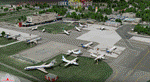
| Vance W. Amory International Airport, St Kitss and Nevis (TKPN), Version 1.0 |
|
Images related to this file:
File Description:
This zip-file contains a detailed yet very frame-rate friendly scenery for the Vance W. Amory International Airport, Newcastle, St. Kitts and Nevis. Version 1.0. Added as much photo-real details as possible. Limited night texture at this time. Included the "Hurricane Hill" so the approach of runway 10 becomes a bit challenging like in real-world. Charts included.
For the trees to show up around the airfield you need to have installed: Gerrish Gray's trees_v3.zip.
| Filename: | Vance_W_Amory_International_Airport_St_Kitss_and_N.zip |
| License: | Freeware, limited distribution |
| Added: | 22nd March 2010, 16:53:20 |
| Downloads: | 2,545 |
| Author: | Marcel Ritzema |
| Size: | 2.77 MB |
| Category: Flight Simulator 2004 - Scenery | |
| Kamouraska Airfield --- Québec Short Hops |
|
File Description:
Kamouraska is a beautiful region situated, a bit downstream from my Rivière Ouelle scenery. It is a basic field but with all the services. The night lighting for the runway features my old vintage style kerosene torch balls. The dirt/grass strip field is fictitious and so is my rendition of the village. Included is the afcad file by Tom Constantine and very soon, Tom will add traffic between all my QSH sceneries. Thanks to Tom for bringing those scenes to life.
| Filename: | Kamouraska_Airfield__Qubec_Short_Hops.zip |
| License: | Freeware |
| Added: | 7th December 2003, 04:13:37 |
| Downloads: | 2,402 |
| Author: | Léon Louis |
| Size: | 5.45 MB |
| Category: Flight Simulator 2004 - Scenery | |
| Victorian Airfields v1.3 Upgrade |
|
File Description:
This file upgrades the Victorian Airfields v1.2 scenery pack for
FS2004 to v1.3. With this upgrade, all 120 airfields will display
in the 'select airport search addon scenery facility. Now you will
be able to place your aircraft directly at any of the included
fields. There are also 4 new strips...Barrabool, Elmore, Moonambel'
and Noelhurst.
YOU MUST HAVE VICTORIAN AIRFIELDS SCENERY V1.2 TO USE THIS UPGRADE!
SEARCH FOR 'sabs_vic_airfieldsv12.zip' AT WWW.AVSIM.COM OR
WWW.OCEANIASIM.COM This file will not work without it!
| Filename: | Victorian_Airfields_v13_Upgrade.zip |
| License: | Freeware |
| Added: | 5th November 2003, 16:36:35 |
| Downloads: | 1,836 |
| Author: | Sebastian Szalai |
| Size: | 4.95 MB |
| Category: Flight Simulator 2004 - Scenery | |
| Chiang Kai Shek Intl |
|
File Description:
This file is a version for the default airport with 75 gates/parking/cargo parking, airport views are from the roof of the control tower (only when you are in TOWER view) for those that have Lee swordy's wonderful afcad_204 found here at Avsim.com can lower the tower height by 45ft you will then be inside the control tower but may find the tinted glass to dark to see clearly especially at night time, and all taxiways now have lighting
| Filename: | Chiang_Kai_Shek_Intl.zip |
| License: | Freeware |
| Added: | 15th November 2003, 12:14:55 |
| Downloads: | 1,784 |
| Author: | Ray Smith |
| Size: | 12.72 KB |
| Category: Flight Simulator 2004 - Scenery | |
| KCGS - College Park Airport - Maryland, USA |
|
Images related to this file:
File Description:
FS2004 Scenery - College Park Airport (IATA: CGS, ICAO: KCGS, FAA LID: CGS) is a public airport located in the City of College Park, in Prince George's County, Maryland, USA. It is the world's oldest continuously operated airport. College Park Airport was established in August 1909 by the United States Army Signal Corps to serve as a training location for Wilbur Wright to instruct two military officers to fly in the government's first airplane. For your flying pleasure by John B. Loney, Jr.
| Filename: | KCGS__College_Park_Airport__Maryland_USA.zip |
| License: | Freeware, limited distribution |
| Added: | 16th April 2016, 11:43:59 |
| Downloads: | 164 |
| Author: | John B. Loney, Jr. |
| Size: | 12.74 MB |
| Category: Flight Simulator 2004 - Scenery | |
| Turkey Mesh, Correction bgl's |
|
File Description:
Created from SRTM 3 arc second data and re-sampled @LOD9 (best fit for this data).
The created area extends from N35E025 (lower left corner) to N44E047 (upper right corner).
You need all the five bgl-files plus the two correction files to cover the whole area.
Otherwise you will have only a coverage of the corresponding file. Matthew Style's SRTM_3ARCSEC_TO_BGL program was used to interpolate the srtm data and automate the bgl file creation (Many Thanks to Matthew for his great utility).
| Filename: | Turkey_Mesh_Correction_bgls.zip |
| License: | Freeware |
| Added: | 19th December 2003, 02:23:34 |
| Downloads: | 5,980 |
| Author: | Abdulkadir Ozturk |
| Size: | 1.77 MB |
© 2001-2026 AVSIM Online
All Rights Reserved
Privacy Policy |