
Where Flight Simulation Enthusiasts Gather from Around the World!
AVSIM Library - Search Results

| Category: Flight Simulator 2004 - Scenery | |
| Joplin Regional Airport |

|
Images related to this file:
File Description:
FS9 Scenery - Joplin Regional Airport (IATA: JLN, ICAO: KJLN) is a public airport located four miles (6 km) north of the central business district (CBD) of Joplin, a city in Jasper County, Missouri, USA. The airport covers 970 acres (393 ha) and has three runways. It offers commercial airline service subsidized by the Essential Air Service program. Joplin Regional Airport is owned by the City Of Joplin. The longest runway is a paved runway extending 6503 feet. The facility is at an elevation of 981 feet. This scenery was created using Instant Scenery by John B. Loney, Jr.
| Filename: | Joplin_Regional_Airport.zip |
| License: | Freeware, limited distribution |
| Added: | 30th December 2009, 21:53:28 |
| Downloads: | 618 |
| Author: | John B. Loney, Jr. |
| Size: | 1019.39 KB |
| Category: Flight Simulator 2004 - Scenery | |
| Marsh Harbour Airport (MYAM) - Bahamas |
|
Images related to this file:
File Description:
This is #3 in a series of Bahama airports I will be redesigning so you can enjoy island hopping throughout the many different islands. This airport and many of the other Bahama Island Airports, I re-design, can easily be reached, from the Florida mainland, flying GA Aircraft from Fort Lauderdale, Miami Intl, Palm Beach Intl and many other Florida Airports. This is a re-design of the FS9/FS2004 default airport. All of the coordinates, comm frequencies, buildings, taxiways etc are correct per AirNav and Google Earth. The scenery was designed using ADE 9x and EZ-Scenery.
| Filename: | Marsh_Harbour_Airport_MYAM__Bahamas.zip |
| License: | Freeware |
| Added: | 17th March 2012, 10:06:03 |
| Downloads: | 910 |
| Author: | Bruce Bouley |
| Size: | 208.65 KB |
| Category: Flight Simulator 2004 - Scenery | |
| Green Ground Service Vehicle Library |
|
Images related to this file:
File Description:
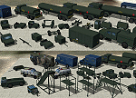
Inspired by the superior work of Michael Carr I have developed a small library of Ground Service Equipment. These objects are mostly painted in the standard olive drab you find at many military airfields. As with all my work the emphasis is on Frame-Rates and not microscopic reality so squint a little and pretend. As some of these objects have been included in my earlier scenery releases, as well as used by other designers, the GUIDs are the same and your existing scenery should not be affected. This will the final version/release of this library. PLEASE READ THE INSTALLATION NOTES CAREFULLY
| Filename: | Green_Ground_Service_Vehicle_Library.zip |
| License: | Freeware, limited distribution |
| Added: | 27th April 2014, 05:34:06 |
| Downloads: | 6,804 |
| Author: | John Stinstrom |
| Size: | 1.05 MB |
| Category: Flight Simulator 2004 - Scenery | |
| Deadmans Cay Airport (MYLD) - Bahamas |
|
Images related to this file:
File Description:
This is #2 in a series of Bahama airports I will be redesigning so you can enjoy island hopping throughout the many different islands. This airport and many of the other Bahama Island Airports, I re-design, can easily be reached, from the Florida mainland, flying GA Aircraft from Fort Lauderdale, Miami Intl, Palm Beach Intl and many other Florida Airports. This is a re-design of the FS9/FS2004 default airport. All of the coordinates, comm frequencies, buildings, taxiways etc are correct per AirNav and Google Earth. The scenery was designed using ADE 9x and EZ-Scenery.
| Filename: | Deadmans_Cay_Airport_MYLD__Bahamas.zip |
| License: | Freeware |
| Added: | 17th March 2012, 10:06:09 |
| Downloads: | 838 |
| Author: | Bruce Bouley |
| Size: | 467.5 KB |
| Category: Flight Simulator 2004 - Scenery | |
| Mt Taranaki/Egmont, NZ, Photoreal Scenery |
|
File Description:
40 x 50 kilometres of photo-real scenery. Fully autogenned, daytime summer textures only. (It will display throughout the year though.)
This showcases the amazing volcanic Mt Taranaki. Like many New Zealand mountains it has both a Maori and European name. Mt Taranaki dominates the Taranaki landscape, and is a spectacular example of of how the central North Island has been effected by volcanic activity.
This is a remake of the original Godzone Taranaki scenery adjusted to match the new elevaton meshes. It is best with the Geographx 20m elevation mesh, and the minimum recommended mesh is the Geographx 75m.
| Filename: | Mt_TaranakiEgmont_NZ__Photoreal_Scenery.zip |
| License: | Freeware, limited distribution |
| Added: | 16th January 2006, 05:57:36 |
| Downloads: | 4,875 |
| Author: | Robin Corn |
| Size: | 40.09 MB |
| Category: Flight Simulator 2004 - Scenery | |
| RAF Woodbridge/EGVG |
|
File Description:
RAF Woodbridge, third in the series of ex USAFE airfields in the UK - was built
in 1943/44 as a primary diversion field and was one of three fields in England
equipped with a 250yd wide - three lane runway.( The other two fields were
Manston in Kent and Carnaby in Yorkshire).The USAFE arrived in 1952 and stayed
until the 90s.The field is one of the "twin Bases" the other being RAF
Bentwaters.This scenery shows the field as it was in the last few years of USAFE
use.Scenery by Dave Fagan with AFCAD by David Hanstater.
| Filename: | RAF_WoodbridgeEGVG.zip |
| License: | Freeware |
| Added: | 11th May 2010, 01:14:59 |
| Downloads: | 3,033 |
| Author: | Dave Fagan & David Hanstater |
| Size: | 5.71 MB |
| Category: Flight Simulator 2004 - Scenery | |
| El Formosa - Taiwan Scenery Project, Part 8 |
|
File Description:
Fengnin Airport (aka Taitung Airport, RCFN) is located in the southeast of Taiwan. Being known as the last pure land in Taiwan, Taitung County has lots of precious nature and cultural resources. With Green Island (Part7) and Lanyu Island (Part5), this area has become one of the most important tourist attractions in Taiwan. In order to hold more traffic and provide better service, Fengnin Airport also experiences lots of change during these years. With Gmax technology, we are proud to introduce this highly detailed airport and hope you find great pleasure in flying this county. Require El Formosa Part1, 3, 6, and 7.
| Filename: | El_Formosa__Taiwan_Scenery_Project_Part_8.zip |
| License: | Freeware, limited distribution |
| Added: | 5th May 2006, 13:33:02 |
| Downloads: | 12,510 |
| Author: | Formosa Group |
| Size: | 3.34 MB |
| Category: Flight Simulator 2004 - Scenery | |
| Salmon River Safari |
|
File Description:
The Salmon River is known as the "River of No Return." Elevations in this wilderness vary from 610 to 3050 meters. Flying into and out of these high altitude short grass and dirt strips will give you a real challange, as well as an opportunity to enjoy the scenery.
No other files are required. Contains full maps, sectional chart, and instructions.
You can do this with the stock Cessna 182RG, but you may want to download John L. Woodward's BEAVER_WHEELS_2005.zip available here on Avsim.com. You'll probably appreciate a little more power and climbing ability to get out of some of these strips!
| Filename: | Salmon_River_Safari.zip |
| License: | Freeware |
| Added: | 3rd July 2006, 01:04:35 |
| Downloads: | 993 |
| Author: | Bill Baldwin |
| Size: | 1.87 MB |
| Category: Flight Simulator 2004 - Scenery | |
| Canadian and Northern USA Winter Flying |
|
File Description:
This is an expanded version of a previous post a year ago, and stretches from east of Quebec City through Quebec, Ontario, and Manitoba, and now also through Saskatchewan, and into Alberta (past Calgary). There is also a northern area roughly centered on Hudson Bay. The exact coverages are given in the notes. All rivers and lakes within the area will "freeze" and allow ski planes to land, or even wheeled planes come to that. And it is not permanent, when you want to go back to floats just "untick" it in the FS library, and it will melt. The area covered crosses into the US too, down to around 45 degrees north, so that means most of Montana, all of North Dakota, half of Minnesota, and some of Wisconsin, Michigan etc. It seemed silly to stop at the border. Ultimate Terrain is highly recommended, so that there will actually be the right lakes and rivers ready to freeze.
| Filename: | Canadian_and_Northern_USA_Winter_Flying.zip |
| License: | Freeware |
| Added: | 26th May 2008, 13:24:29 |
| Downloads: | 669 |
| Author: | Roger Wensley |
| Size: | 354.86 KB |
| Category: Flight Simulator 2004 - Scenery | |
| Ontario Small Fields in Canada: #04 Stoney Point (Le Cunff) CRML V1 |
|
Images related to this file:
File Description:
This is the fourth in a series of small airfields in southern Ontario, Canada. It is Stoney Point (Le Cunff) CRML, a field near a small town (Stoney Point) close to Lake St Clair. The airfield has a grass runway of 2,250 feet, aligned 18/36; with trees around the house gardens between road and runway the south threshold is displaced by 250 feet. The markers approximately show the touchdown point north of the runway end. Le Cunff is the family name of the owners, included to differentiate between this and another Stoney Point field, CRJ2. I found the default FS9 airfield at the correct elevation of 625 feet, but sitting on a plateau, despite my Genesis Mesh. This looked so unreal that I have revised this to an incorrect lower elevation of 580. So if you find the airfield sitting in a hole in your installation you now know the reason. Let me know, with a screenshot please.
| Filename: | Ontario_Small_Fields_in_Canada_04_Stoney_Point_Le_.zip |
| License: | Freeware, limited distribution |
| Added: | 29th July 2015, 16:08:32 |
| Downloads: | 146 |
| Author: | Roger Wensley |
| Size: | 1.6 MB |
© 2001-2026 AVSIM Online
All Rights Reserved
Privacy Policy |