
Where Flight Simulation Enthusiasts Gather from Around the World!
AVSIM Library - Search Results

| Category: Flight Simulator 2004 - Scenery | |
| EGGP VFR Landmarks - Jaguar Halewood and Local Factories Ver 1.0 |

|
File Description:
This is the seventh in a series of individual landmark sceneries for use while VFR flying in the area of Liverpool John Lennon Airport (EGGP). This version has been produced using Gmax and the FS2004 Scenery SDK. Therefore it is only compatible with FS2004, sorry! The scenery is aligned to the Visual Flight / Getmapping VFR Scenery published by Just Flight. However, it is also compatible with the FS2004 default scenery.
This scenery has been designed to compliment the Liverpool John Lennon Airport Scenery also by DerboSoft.
| Filename: | EGGP_VFR_Landmarks__Jaguar_Halewood_and_Local_Fact.zip |
| License: | Freeware |
| Added: | 16th November 2005, 23:04:02 |
| Downloads: | 4,598 |
| Author: | Paul Derbyshire |
| Size: | 199.58 KB |
| Category: Flight Simulator 2004 - Scenery | |
| Buena Vista, Central Colorado Reg. (KAEJ form. 7V1), Colorado, Photo-Scenery (FS9 & FSX) |
|
Images related to this file:
File Description:
This region covers the area around Buena Vista and Central Colorado Reg. (KAEJ form. 7V1). It extends
my Leadville scenery to the south and brings you another 3.500 sq km of beautiful Colorado in 4.7m/pix quality. High resolution versions of this scenery for FS9 and FSX (much sharper, but larger and multiple downloads) are available at www.blueskyscenery.com/GNB_South3West.html . The screenies are taken from the high-res versions, so expect this version to be slightly more blurry. YourDonation@Work: Dedicated to Matias and Markus.
| Filename: | Buena_Vista_Central_Colorado_Reg_KAEJ_form_7V1_Col.zip |
| License: | Freeware, limited distribution |
| Added: | 7th February 2010, 11:31:14 |
| Downloads: | 1,576 |
| Author: | Gottfried Razek - blueskyscenery.com |
| Size: | 93.89 MB |
| Category: Flight Simulator 2004 - Scenery | |
| KBAB Beale Air Force Base, California |
|
Images related to this file:
File Description:

Home to the 9th reconnaissance Wing, Beale AFB lies among the low rolling hills of Northern California. Beale provides training, and operational support for several aircraft; the Lockheed U-2, Northrop T-38, Grumman RQ-4A, and Beechcraft MC-12W. Many of these aircraft, particularly the U-2 operate on extended deployment overseas. Although designed to work with the 'Beale AFB' package from the Military AI Works group this scenery is a stand alone package and will work fine even without the recommended downloads.
| Filename: | KBAB_Beale_Air_Force_Base_California.zip |
| License: | Freeware, limited distribution |
| Added: | 14th August 2012, 20:23:28 |
| Downloads: | 1,737 |
| Author: | John Stinstrom |
| Size: | 5.37 MB |
| Category: Flight Simulator 2004 - Scenery | |
| Forggensee, v2 Update |
|
Images related to this file:
File Description:

This UPDATE enhances the existing Forggensee Water-Airport(EDAF).
Klaus Jone did a magnificent job in creating this scenery for us flightsimmers, and my enhancements do NOT alter any Scenery Objects by Klaus Jone. The buildings are the same. And the number of AI planes and ships are unchanged.
My enhancements modify the BEHAVIOR of the Ships.
But the floatplane traffic is so superbly programmed that no further modifications are necessary.
Mr. Klaus Jone passed away in May 2009, and it is my intention to preserve Forggensee pretty much as HE designed it. Except for modifying the BEHAVIOR of the AI traffic, to spread it out to cover the entire area of Lake Forggensee. As the screenshots I've included illustrate.
Naturally, these updated files require that Forggensee Part 1 and Part 2 are ALREADY installed in your FS2004. My part here was to perform a few tweaks to make the AI traffic spread out all over Lake Forggensee, and ensure that ALL wake/spray effects are visible. As Klaus Jone stated: "There is some amazing traffic on the lake, have a look and have fun!"
| Filename: | Forggensee_v2_Update.zip |
| License: | Freeware |
| Added: | 18th April 2011, 19:13:38 |
| Downloads: | 726 |
| Author: | Klaus Jone, Ronald Falzon |
| Size: | 1.41 MB |
| Category: Flight Simulator 2004 - Scenery | |
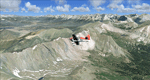
| Alps LOD10 Topo Mesh - Switzerland and France |
|
Images related to this file:
File Description:
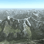
Yet another terrain mesh package of the European Alps? Well, this one is different in that it is NOT primarily based on the Shuttle Radar (SRTM) data with their incomplete coverage of prominent peaks and ridges. Instead, most of the source data for this project were developed over many months by Jonathan de Ferranti using detailed topographic maps. While Jonathan's work is unrelated to flight simulation he kindly gave me permission to compile his data for use in FS. The result is a wonderful improvement in detail and accuracy over any existing SRTM- or DTED-based mesh file, freeware or commercial (a link to an extensive set of screenshot comparisons is included in the read-me file).
I've compiled the source data at LOD10 (38-m) grid resolution because the coverage area is smaller than most existing mesh files. Thus, anyone can use these files without having to first uninstall their current mesh set. Also included are LOD9 and LO8 buffer mesh files. Note: if you own Switzerland Professional with its high-resolution terrain mesh then you don't need this package, at least not the Switzerland files!
| Filename: | Alps_LOD10_Topo_Mesh__Switzerland_and_France.zip |
| License: | Freeware, limited distribution |
| Added: | 30th May 2010, 09:51:03 |
| Downloads: | 58,987 |
| Author: | Holger Sandmann, Jonathan de Ferranti |
| Size: | 50.03 MB |
| Category: Flight Simulator 2004 - Scenery | |
| Alaska South Slope 7; Kobuk OBU & Dahl Creek DCK |
|
Images related to this file:
File Description:
There are four main northwestern Alaska towns which are serviced by Alaska Airlines, and from which local flights spread out. The northernmost is Barrow. Southwest of Barrow is Kotzebue, then Nome, and the furthest south is Bethel (not yet made). This is a continuation of the series for the flights from Kotzebue, 170 miles to the east where Kobuk is on the bank of the Kobuk River, and Dahl Creek is 2 miles to the north. Kobuk is a small village on the Kobuk River, like Ambler and Shungnak, but with a population of only around 150. The river is the reason for the existance of the villages as it served (and still does) as both a source of food and a transport route. The airfield is just beside the village, with a runway around 4,500 feet of lit gravel and aligned 09-27, with PAPI on both ends. There are scheduled flights by Era (now renamed Ravn) and by Bering Air, both of them originating in Kotzebue and routing east to Ambler, Shungnak, Kobuk, and then back again. The AI includes these flights along with Everts Air and GA. The FS9 airfield has been relocated by approximately a mile to the correct position, and the elevation accordingly adjusted. The Dahl Creek strip is publicly owned, with no maintenance and a deteriorating gravel runway that has not long to survive. This probably does not work properly without Ultimate Terrain Alaska Canada as the village is now on the river bank. I am presuming that you have downloaded and installed Nome PAOM, along with the instructions on how to adjust Ultimate Terrain Alaska Canada to get the most realistic results. If you are not making the UT adjustments then you may be seeing duplicated roads, as I am including new local dirt or gravel roads to connect village to airfield etc to get the best overall result; I will not be making alternate versions.
| Filename: | Alaska_South_Slope_7_Kobuk_OBU__Dahl_Creek_DCK.zip |
| License: | Freeware, limited distribution |
| Added: | 13th October 2016, 18:10:08 |
| Downloads: | 233 |
| Author: | Roger Wensley |
| Size: | 2.94 MB |
| Category: Flight Simulator 2004 - Scenery | |
| EGTR - Elstree Aerodrome - Elstree, UK |
|
Images related to this file:
File Description:
FS2004 version of the Elstree (EGTR) aerodrome just north of London. A very popular GA airport. Complete with custom built ground polygons, custom built buildings, traffic files using the default FS2004 GA airplanes.
| Filename: | EGTR__Elstree_Aerodrome___Elstree_UK.zip |
| License: | Freeware |
| Added: | 12th January 2015, 11:11:37 |
| Downloads: | 317 |
| Author: | Anders Samuelsson |
| Size: | 10.15 MB |
| Category: Flight Simulator 2004 - Scenery | |
| VTBD 2006 |
|
File Description:
VTBD or DonMuang Intl airport is the Thailand main international airport that also serve both of domestic and international flights. There are a lot of traffics are taking off/landing in every second.
| Filename: | VTBD_2006.zip |
| License: | Freeware |
| Added: | 15th January 2006, 00:38:47 |
| Downloads: | 16,014 |
| Author: | Siamavsim.com, Sira I, Polapan S, Teeravuth B, and Krit T |
| Size: | 4.47 MB |
| Category: Flight Simulator 2004 - Scenery | |
| SBSV Default Airport Improvement |
|
File Description:
FS2004 SBSV Default Airport Improvement. Scenery of Dep. Luis Eduardo Magalhaes Airport (SBSV) city of Salvador, Brasil. Simple default airport improvement to make it more realistic. It also includes taxiway and AFCAD modifications.
| Filename: | SBSV_Default_Airport_Improvement.zip |
| License: | Freeware |
| Added: | 27th February 2006, 17:36:10 |
| Downloads: | 4,897 |
| Author: | Roberto Zanolli |
| Size: | 1.49 MB |
| Category: Flight Simulator 2004 - Scenery | |
| Moora (YMOA) - Western Australia |
|
File Description:
Moora YMOA - Western Australia.
Another country airstrip situated approx 74 n.m. north of Perth in Western Australia, given a fictitious ALA code of YMOA. Requires the rwy12 Static Object Library, see readme included.
| Filename: | Moora_YMOA__Western_Australia.zip |
| License: | Freeware |
| Added: | 5th May 2006, 13:29:51 |
| Downloads: | 637 |
| Author: | Derek Froud |
| Size: | 14.53 KB |
© 2001-2026 AVSIM Online
All Rights Reserved
Privacy Policy |