
Where Flight Simulation Enthusiasts Gather from Around the World!
AVSIM Library - Search Results

| Category: Flight Simulator 2004 - Scenery | |
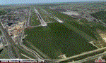
| KGRR Grand Rapids, MI. Gerald R. Ford International Airport |

|
Images related to this file:
File Description:

Grand Rapids, MI. KGRR airport. Complete makeover. New Terminal,Jetways. Correct airline gate assignments for Delta, Air Canada, United, Air Tran and Allegiant and American. Correct AI gates. Complete new FedEx cargo area. General aviation area and FBO. Even has a restaurant for those $100 hamburger fly ins. Tons of detail.
The complete RWY12 and EZ Scenery object libraries are needed, Read the READ ME file included for more detail.
| Filename: | KGRR_Grand_Rapids_MI_Gerald_R_Ford_International_A.zip |
| License: | Freeware |
| Added: | 21st September 2012, 19:06:23 |
| Downloads: | 1,795 |
| Author: | Rob Touchtone |
| Size: | 3.2 MB |
| Category: Flight Simulator 2004 - Scenery | |
| North Bay 2008 |
|
Images related to this file:
File Description:
FS2004 North Bay 2008. This is a new scenery package for North Bay, Ontario, Canada. It contains photo terrain textures for all seasons, all new autogen, all objects and textures with Levels of Detail (LOD), traffic, and some optional airports in the surrounding areas to support the traffic. Very frame-rate friendly. Author is Fern Marques with aircraft by Dave Pearce. Replaces North Bay V1 and V2 and Manitu Islands. For free distribution only.
| Filename: | North_Bay_2008.zip |
| License: | Freeware |
| Added: | 25th May 2010, 19:19:00 |
| Downloads: | 1,678 |
| Author: | Fern Marques with planes by Dave Pearce |
| Size: | 48.07 MB |
| Category: Flight Simulator 2004 - Scenery | |
| E T Joshua TVSV on Saint Vincent in the eastern Caribbean |
|
Images related to this file:
File Description:
Saint Vincent island is the northernmost of the group of islands known as St Vincent and the Grenadines, just south of St Lucia. St Vincent is around 17 miles long and 10 miles wide and by far the largest in the group, and the islands have a total population of around 120,000. E T Joshua is at the southern end of the island, adjacent to the capital Kingstown. There is a new airport under construction a few miles to the east which will have a longer runway and a larger apron, and when it is ready E T Joshua will probably be closed and redeveloped.
The terminal and the other smaller buildings are all made with photographic textures; the terminal is now quite old and has seen better days. The airport is a hub for small local airlines and also has regular LIAT flights connecting to other islands. The runway is just a shade under 4,700 feet of asphalt, so there are no direct flights from Europe. The new airport to the east is depicted as under construction; obviously I have not flown there and I have not tried to depict the terminal building which is also under construction but a mystery to me.
| Filename: | E_T_Joshua_TVSV_on_Saint_Vincent_in_the_eastern_Caribbean.zip |
| License: | Freeware, limited distribution |
| Added: | 11th June 2013, 16:29:42 |
| Downloads: | 536 |
| Author: | Roger Wensley |
| Size: | 3.13 MB |
| Category: Flight Simulator 2004 - Scenery | |
| UUEE Moscow Sheremetyevo 2015 DEMO |
|
Images related to this file:
File Description:
UUEE MOSCOW SHEREMETYEVO 2015 DEMO is a scenery of UUEE Sheremetyevo airport in Moscow, Russia, fully compatible with FS2004.
This product is a fully functional DEMO version of the commercial payware product. Most objects are modelled as in the full version but covered with low resolution textures. Using this free demo ensures no problems with online (VATSIM, IVAO, multiplayer etc.) flying in case some users use the payware scenery and some don't.
Moscow is the capital city and the most populous federal subject of Russia. The city is a major political, economic, cultural and scientific center in Russia and in Eastern Europe. Sheremetyevo International Airport (SVO/UUEE) is an international airport located in Khimki, Moscow Oblast. It is a hub for passenger operations of the Russian international airline Aeroflot, and is one of the three major airports that serve Moscow, along with Domodedovo International Airport and Vnukovo International Airport
The product is equipped with an automatic installer, which means that the scenery will be automatically added to the Flight Simulator Scenery Library. Please uninstall all previous versions of this airport you may have installed before. Please make also sure that no duplicated AFCAD files are installed.
Enjoy your virtual flying with Drzewiecki Design!
| Filename: | UUEE_Moscow_Sheremetyevo_2015_DEMO.zip |
| License: | Commercial demo |
| Added: | 4th April 2016, 21:52:46 |
| Downloads: | 849 |
| Author: | Drzewiecki Design |
| Size: | 13.68 MB |
| Category: Flight Simulator 2004 - Scenery | |
| Caballococha, Peru |
|
File Description:
Caballococha, Peru - Actually I have found only one photo of the town along the Amazon River and it was only of the Plaza. This is a total impressionistic file. Creates the town, riverside features (Piers, Ferry landing) and a few features to the default airport.
New AFCAD created offering parking and a taxiway, plus two water start locations. Again totally fictious. BUT enjoy.
One thing about Caballococha is that it is along a highly navagatable portion of the Amazon and with the fantastic array of Watercraft available offers, I believe, unlimited simming possibilities.
I included the .XML file for rwy12, if you are into enhancing your own scenery...please do feel free to modify or add as desired. This scenery DOES require both LAGO FSE (Payware) and RWY12 available here at avsim) to work.
questions or comments PLEASE do e-mail me ... I will respond as rapidly as possible.
[email protected]
| Filename: | Caballococha_Peru.zip |
| License: | Freeware |
| Added: | 9th April 2006, 04:19:26 |
| Downloads: | 714 |
| Author: | Dale Caruso |
| Size: | 225.37 KB |
| Category: Flight Simulator 2004 - Scenery | |
| Tillsonburg CNQ4 in Ontario Canada REPLACEMENT |
|
File Description:
This is a replacement (though complete in itself) for my original Tillsonburg post with the corrected office building included. Tillsonburg is a small town in southwest Ontario, mid way between Toronto, Buffalo, and Detroit. The airfield is some four miles north of the town. It was originally built by the RCAF as an emergency grass field to support flying training in WW2. It now has two grass runways, each 2,400 feet long, and another 4,000 feet long that is asphalt. There is a company that carries out painting and ulholstery work, a flight school, and of course the Canadian Harvard Aircraft Association, which is a volunteer organisation that does what the title suggests and takes care of Harvards, I think six of them plus a Tiger Moth, and something else. And when I was there two years ago and in the winter there was a licensed AME just starting up.
| Filename: | Tillsonburg_CNQ4_in_Ontario_Canada_REPLACEMENT.zip |
| License: | Freeware |
| Added: | 12th November 2008, 14:48:26 |
| Downloads: | 663 |
| Author: | Roger Wensley & Jim Turner |
| Size: | 1.43 MB |
| Category: Flight Simulator 2004 - Scenery | |
| Armstrong Ontario; one airfield and two float bases |
|
File Description:
Armstrong CYYW airfield is 70 miles northeast of Thunder Bay, and close to Lake Nipigon. There isn't much of interest at the airfield by way of buildings (as there aren't many buildings!) and the only plane I saw was a fire fighting Canadaair CL 415. A basic airfield with one runway with lights and one without, and no maintenance. There is fuel, but it is locked up and not for sale.
The two float bases are 5 miles west (CJF6) and 10 miles southwest (CKN6) of Armstrong airfield. Lake Mackenzie is home to two companies, Armstrong Outposts (two Beavers) and Huron Air & Outfitters (an Otter and a Beaver) who both run fishing and hunting lodges. Wilderness North are further south on Lake Waweig, and I think they fly two Otters and a Beaver to their outpost camps. You need Ultimate Terrain, or there won't be any lakes!
| Filename: | Armstrong_Ontario_one_airfield_and_two_float_bases.zip |
| License: | Freeware |
| Added: | 24th February 2009, 00:51:42 |
| Downloads: | 892 |
| Author: | Roger Wensley |
| Size: | 7.03 MB |
| Category: Flight Simulator 2004 - Scenery | |
| Snowden Farm CF39, in Ontario Canada |
|
Images related to this file:
File Description:
Another airfield close to Highway 11, further south towards Lake Simcoe. Snowden Farm is a bit over five miles south of Huntsville and east of of highway 11. The grass runway 12/30 is just over 2,000 feel long and sandwiched between Penfold Lake to the north, and on the south side a large pond with a creek that connects to the much larger Mary Lake to the east. There is a hangar and a shed at the eastern end of the runway. There is one airfield scenery file, and two landclass files to provide the grassed area and the large pond and creek. I presume that the pond was just a little too small to register with Ultimate Terrain. The scenery might work without Ultimate Terrain but I haven't tested it, and for sure without it Penfold Lake and probably Mary Lake won't appear.
| Filename: | Snowden_Farm_CF39_in_Ontario_Canada.zip |
| License: | Freeware, limited distribution |
| Added: | 5th February 2010, 03:51:07 |
| Downloads: | 295 |
| Author: | Roger Wensley |
| Size: | 837.43 KB |
| Category: Flight Simulator 2004 - Scenery | |
| Lake Powell East / Natural Bridges National Monument, Utah, Photo-Scenery |
|
Images related to this file:
File Description:
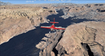
Lake Powell East / Natural Bridges National Monument, Utah, Photo-Scenery (FS9 & FSX)
This scenery covers the eastern part of Lake Powell from just south of Hite (UT03) and goes down south along White Canyon, Natural Bridges National Monument and the Grand Gulch Primitive Area all the way to the San Juan River. It extends my Canyonlands sceneries to the south and brings you another 3.500 sq km of wonderful southern Utah in 4.7m/pix quality. To explore the scenery depart from Cal Black Memorial Apt. (U96) and head east. High resolution versions of this scenery for FS9 and FSX (much sharper, but larger and multiple downloads) are available at www.blueskyscenery.com/CNY_South2West.html. The screenies are taken from the high-res versions, so expect this version to be slightly more blurry. YourDonation@Work: Dedicated to Guy, Ruben and EDB.
| Filename: | Lake_Powell_East__Natural_Bridges_National_Monumen.zip |
| License: | Freeware, limited distribution |
| Added: | 4th January 2010, 19:19:43 |
| Downloads: | 1,871 |
| Author: | Gottfried Razek, blueskyscenery.com |
| Size: | 95.26 MB |
| Category: Flight Simulator 2004 - Scenery | |
| Terrace CYXT in BC Canada Updated |
|
Images related to this file:
File Description:
This version of Terrace has night textures that work, good news for the 319 downloaders who did not tell the author that the ones already posted did not work. Why? Terrace is fifteen miles east and inland from Prince Rupert, which is 500 miles north of Vancouver up the BC coast. It is at the point in the mountains where two fjords meet, one coming from Prince Rupert and the other from Kitimat. There are two runways, the main one is a recently-extended 7,500 feet long and lighted 33/15 and the second is 5,373 feet of unlit 03/21. The apron has been enlarged to be able to accomodate a Boeing 737; though I don't think there is an airline using a 737 for flights to Terrace I have parked an Air Canada jet and the pics show the planes that do fly to Terrace, Air Canada and Hawk Air Dash 8-300's. The aircraft and the textures are down-loadable and and can be used for AI.
| Filename: | Terrace_CYXT_in_BC_Canada_Updated.zip |
| License: | Freeware, limited distribution |
| Added: | 3rd July 2010, 03:28:31 |
| Downloads: | 1,064 |
| Author: | Roger Wensley |
| Size: | 3.72 MB |
© 2001-2026 AVSIM Online
All Rights Reserved
Privacy Policy |