
Where Flight Simulation Enthusiasts Gather from Around the World!
AVSIM Library - Search Results

| Category: Flight Simulator 2004 - Scenery | |
| Pokhara Lake - Flatten |

|
File Description:
If you have 3rd. party scenery for Nepal and/or terrain mesh installed, many of your lakes in FS9 may look like the 'Before' picture you can see in the 'ZipDive'. If your lake at Pokhara (near the airport, VNPK) does look like that, then the bgl file in this download will get it back to ground level. If on the other hand your lake looks flat already, then you don't need this download of course!
| Filename: | Pokhara_Lake__Flatten.zip |
| License: | Freeware |
| Added: | 23rd May 2016, 19:37:31 |
| Downloads: | 398 |
| Author: | Martin Stebbing |
| Size: | 996.22 KB |
| Category: Flight Simulator 2004 - Scenery | |
| Quatro de Fevereiro International Airport (FNLU) V1 |
|
Images related to this file:
File Description:
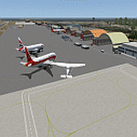
Hello FS9 sim fans who love flying in Africa, In my quest to bring you more African airports, I bring you Aeroporto de Quatro de Fevereiro (IATA: LAD, ICAO: FNLU). This is the International airport of the Republic of Angola (New airport is being buillt and will open in 2023). Scenery was built using Sketchup, ADE,AFLT, SbuilderFs9. Needs RWY12 object library for airport objects to show up. You can get RWY12 object library in AVSIM/Flightsim.
| Filename: | Quatro_de_Fevereiro_International_Airport_FNLU_V1.zip |
| License: | Freeware |
| Added: | 6th March 2022, 19:33:52 |
| Downloads: | 520 |
| Author: | Emmanuel Mwandosya |
| Size: | 30.39 MB |
| Category: Flight Simulator 2004 - Scenery | |
| VEAT Argatala, India |
|
Images related to this file:
File Description:
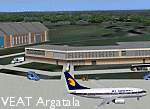
Googly scenery for VEAT Argatala, India - one of the airports that Microsoft seem to have, um, "forgotten" in FS2004. In the real world it is regularly served by Boeings and Airbii of Alliance Air, Indian Airlines, Jet Airways and Kingfisher Airlines (and smaller aircraft), using the 6000 foot runway with little room for manoevre. These scenery files add aprons, taxiways, buildings and other airport features to Flight Simulator's bland representation and allow you, and "AI" traffic, to land, taxi, park and take off realistically. The scenery does not purport to be ultra-accurate. Based on high-detail satellite imagery from Google Earth, the layout is proportianally correct but the added airport features, such as buildings, are built from default Microsoft objects and add-on libraries so will not look like the real thing. You are not obliged to download and install any additional scenery libraries, but to enjoy this scenery in its entirety, you may wish to. It will work fine, with or without. Details of optional additional scenery library downloads are provided within.
[File re-uploaded at request of AVSIM]
| Filename: | VEAT_Argatala_India.zip |
| License: | Freeware |
| Added: | 14th May 2010, 04:49:05 |
| Downloads: | 1,658 |
| Author: | John Hinson |
| Size: | 65.16 KB |
| Category: Flight Simulator 2004 - Scenery | |
| Baton Rouge,La. ( KBTR v2 ) |
|
File Description:
FS2004 KBTR Baton Rouge,La. v2.0
This is an updated version from my old EZ Mega KBTR version 1.0
This Scenery is optimized for use with Ultimate Terrain USA,but should work OK with default land scenery.
This package features a lot of objects around the city of Baton Rouge, such as an accurate rendition of the 473foot tall State capital Building, Cortana mall,Seigen Village Mall,strip malls,banks,restaurants,gas stations,Chemical plants,River Barge Traffic,USS Kidd Destroyer,the two casino boats,the Marriott Hotel off College drive,Louisiana State Police headquarters with its own AFCAD and Helo pads and lots of other stuff.This version does not feature my custom built terminal and hangers,that will come in version 3.
The Airport AFCAD has been once again reworked as well to reflect the newly lengthened Rwy 22R-4L and other stuff.
This has been my test bed for the upcoming version 3 release which will be released by Christmas hopefully.
In the meantime,enjoy this new version equipped with familiar landmarks.
As Always...Enjoy!!!
| Filename: | Baton_RougeLa__KBTR_v2_.zip |
| License: | Freeware |
| Added: | 11th October 2008, 02:15:38 |
| Downloads: | 2,866 |
| Author: | Joe DeGregorio |
| Size: | 13.04 MB |
| Category: Flight Simulator 2004 - Scenery | |
| KNUQ - Moffett Federal Airfield - Mountain View - California (USA) |
|
Images related to this file:
File Description:
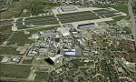
Known originally as Naval Air Station Sunnyvale after its christening in 1933, Moffett Field was renamed in 1942 in honor of Rear Admiral W.A. Moffett a founder of the Navy's Lighter than air program. By this time the LTA program had been reduced to the use of smaller dirigibles for scouting and anti-submarine work but the airfield remained immensely important as a fixed-wing facility due to it's strategic location between Seattle and San Diego. The Ames Research Center established before the war also blossomed into a major post-war aeronautical research and development center due in part to its highly advanced wind tunnel facilities. After the Second World War, Moffett Field developed into a West Coast hub for Patrol and ASW operations against encroaching Soviet missile boats. The NASA presence at Moffett began as early as 1939 with the establishment of the Aames Research Facility and evolving into the sophisticated R&D complex it is today. This particular scenery package attempts to represent the base more or less as it is today.
| Filename: | KNUQ__Moffett_Federal_Airfield__Mountain_View__Cal.zip |
| License: | Freeware |
| Added: | 21st August 2014, 10:41:53 |
| Downloads: | 1,349 |
| Author: | John Stinstrom |
| Size: | 12.36 MB |
| Category: Flight Simulator 2004 - Scenery | |
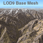
| Himalayas LOD9 Base Mesh, Volume 2 - Southcentral Ranges |
|
Images related to this file:
File Description:

Detailed terrain mesh of the Southcentral Himalayan Ranges, N26-32 E82-90. The files in this package are based on Shuttle Radar (SRTM) Version 2 data but with many of the void areas, especially the most significant sections, filled with elevation data generated from topographic maps by Jonathan de Ferranti. While Jonathan's work is unrelated to flight simulation he kindly gave me permission to compile his data for use in FS. The result is a wonderful improvement in detail and accuracy over any existing mesh file, freeware or commercial, based on SRTM or DTED data alone.
Due to the large area of the Himalayas I've compiled the source data as two separate series: the "Himalayan Peaks" series covers prominent mountains and ranges in higher detail and locally overrides any existing LOD9 terrain mesh. In addition, a LOD9 "base mesh" series, with LOD8 and LOD7 "buffer" mesh files, covering the entire Himalayas, is meant for those who do not yet have an add-on terrain mesh of these beautiful mountains.
| Filename: | Himalayas_LOD9_Base_Mesh_Volume_2__Southcentral_Ra.zip |
| License: | Freeware, limited distribution |
| Added: | 29th May 2010, 09:05:56 |
| Downloads: | 9,447 |
| Author: | Holger Sandmann, Jonathan de Ferranti |
| Size: | 90.25 MB |
| Category: Flight Simulator 2004 - Scenery | |
| Himalayas LOD9 Base Mesh, Volume 1 - Southeastern Ranges |
|
Images related to this file:
File Description:
Detailed terrain mesh of the Southeastern Himalayan Ranges, N26-32 E90-98. The files in this package are based on Shuttle Radar (SRTM) Version 2 data but with many of the void areas, especially the most significant sections, filled with elevation data generated from topographic maps by Jonathan de Ferranti. While Jonathan's work is unrelated to flight simulation he kindly gave me permission to compile his data for use in FS. The result is a wonderful improvement in detail and accuracy over any existing mesh file, freeware or commercial, based on SRTM or DTED data alone.
Due to the large area of the Himalayas I've compiled the source data as two separate series: the "Himalayan Peaks" series covers prominent mountains and ranges in higher detail and locally overrides any existing LOD9 terrain mesh. In addition, a LOD9 "base mesh" series, with LOD8 and LOD7 "buffer" mesh files, covering the entire Himalayas, is meant for those who do not yet have an add-on terrain mesh of these beautiful mountains.
| Filename: | Himalayas_LOD9_Base_Mesh_Volume_1__Southeastern_Ra.zip |
| License: | Freeware, limited distribution |
| Added: | 29th May 2010, 09:01:26 |
| Downloads: | 10,298 |
| Author: | Holger Sandmann, Jonathan de Ferranti |
| Size: | 71.82 MB |
| Category: Flight Simulator 2004 - Scenery | |
| Himalayas LOD9 Base Mesh, Volume 4 - Kashmir and Jammu |
|
File Description:
Detailed terrain mesh of the Kashmir and Jammu Ranges, N30-39 E76-78. The files in this package are based on Shuttle Radar (SRTM) Version 2 data but with many of the void areas, especially the most significant sections, filled with elevation data generated from topographic maps by Jonathan de Ferranti. While Jonathan's work is unrelated to flight simulation he kindly gave me permission to compile his data for use in FS. The result is a wonderful improvement in detail and accuracy over any existing mesh file, freeware or commercial, based on SRTM or DTED data alone.
Due to the large area of the Himalayas I've compiled the source data as two separate series: the "Himalayan Peaks" series covers prominent mountains and ranges in higher detail and locally overrides any existing LOD9 terrain mesh. In addition, the LOD9 "base mesh" series, with LOD8 and LOD7 "buffer" mesh files, covering the entire Himalayas, is meant for those who do not yet have an add-on terrain mesh of these beautiful mountains.
| Filename: | Himalayas_LOD9_Base_Mesh_Volume_4__Kashmir_and_Jam.zip |
| License: | Freeware, limited distribution |
| Added: | 22nd February 2006, 20:32:50 |
| Downloads: | 7,503 |
| Author: | Holger Sandmann, Jonathan de Ferranti |
| Size: | 29.24 MB |
| Category: Flight Simulator 2004 - Scenery | |
| Himalayas LOD9 Base Mesh, Volume 3 - Southwestern Ranges |
|
Images related to this file:
File Description:

Detailed terrain mesh of the Southwestern Himalayan Ranges, N28-37 E78-82. The files in this package are based on Shuttle Radar (SRTM) Version 2 data but with many of the void areas, especially the most significant sections, filled with elevation data generated from topographic maps by Jonathan de Ferranti. While Jonathan's work is unrelated to flight simulation he kindly gave me permission to compile his data for use in FS. The result is a wonderful improvement in detail and accuracy over any existing mesh file, freeware or commercial, based on SRTM or DTED data alone.
Due to the large area of the Himalayas I've compiled the source data as two separate series: the "Himalayan Peaks" series covers prominent mountains and ranges in higher detail and locally overrides any existing LOD9 terrain mesh. In addition, the LOD9 "base mesh" series, with LOD8 and LOD7 "buffer" mesh files, covering the entire Himalayas, is meant for those who do not yet have an add-on terrain mesh of these beautiful mountains.
| Filename: | Himalayas_LOD9_Base_Mesh_Volume_3__Southwestern_Ra.zip |
| License: | Freeware, limited distribution |
| Added: | 30th May 2010, 10:00:26 |
| Downloads: | 155,808 |
| Author: | Holger Sandmann, Jonathan de Ferranti |
| Size: | 62.16 MB |
| Category: Flight Simulator 2004 - Scenery | |
| Himalayas LOD9 Base Mesh, Volume 5 - Hindu Kush and Pamir |
|
Images related to this file:
File Description:

Detailed terrain mesh of the Hindu Kush and Pamir Ranges, N32-40 E70-76. The files in this package are based on Shuttle Radar (SRTM) Version 2 data but with many of the void areas, especially the most significant sections, filled with elevation data generated from topographic maps by Jonathan de Ferranti. While Jonathan's work is unrelated to flight simulation he kindly gave me permission to compile his data for use in FS. The result is a wonderful improvement in detail and accuracy over any existing mesh file, freeware or commercial, based on SRTM or DTED data alone.
Due to the large area of the Himalayas I've compiled the source data as two separate series: the "Himalayan Peaks" series covers prominent mountains and ranges in higher detail and locally overrides any existing LOD9 terrain mesh. In addition, the LOD9 "base mesh" series, with LOD8 and LOD7 "buffer" mesh files, covering the entire Himalayas, is meant for those who do not yet have an add-on terrain mesh of these beautiful mountains.
| Filename: | Himalayas_LOD9_Base_Mesh_Volume_5__Hindu_Kush_and_.zip |
| License: | Freeware, limited distribution |
| Added: | 29th May 2010, 08:57:29 |
| Downloads: | 7,603 |
| Author: | Holger Sandmann, Jonathan de Ferranti |
| Size: | 85.72 MB |
© 2001-2026 AVSIM Online
All Rights Reserved
Privacy Policy |