
Where Flight Simulation Enthusiasts Gather from Around the World!
AVSIM Library - Search Results

| Category: Flight Simulator 2004 - Scenery | |
| LFQX Laon-Couvron AB 1955-62 |

|
Images related to this file:
File Description:
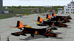
From 1950 to 1967 the USAF set up and maintained bases in France, with the agreement of the French government, as part of its commitment to the North Atlantic Treaty Organisation. Laon AB was one of the ten main air bases which supported both attack and air defence capabilities. Many people do not appreciate the sheer extent of the USAF bases in France at this time and the reasons leading to the USAF departure in 1967. There is a link to a fine article on all this included.
This is the second in a series of USAFE bases in France, the first being LFJA Chaumont AB. This scenery and traffic represent Laon Air Base during the years 1955 to 1962. Custom Tower and Hangars by Dan French with Custom aircraft paints by Ken Lawson and DeltaDart. Traffic files and the aircraft and paints needed are provided for 1955 (including the Black Knights B-57 Demonstration Team), 1957, 1959 and 1962.
| Filename: | LFQX_LaonCouvron_AB_195562.zip |
| License: | Freeware |
| Added: | 22nd November 2023, 16:08:03 |
| Downloads: | 88 |
| Author: | Al Von Pingel, Ken Lawson, Dan French |
| Size: | 35.77 MB |
| Category: Flight Simulator 2004 - Scenery | |
| Maniwaki CYMW in Ontario Canada |
|
Images related to this file:
File Description:
Maniwaki airfield is seven miles south of the town of Maniwaki and some 60 miles north of Ottawa, up the Gatineau River. There is a generous 5,000 feet of runway 03/21 that is 150 feet wide and in bad condition, so bad that there are now almost no markings of any sort (even a centre line, the apron has more paint than the runway!) and the whole lot is going to be redone next summer. The apron is large, and in the summer accomodates two Bombardier CL 415 fire fighting amphibians, which is why there is a large access platform loitering on the apron. There are only five hangars on the field with another one tucked into the trees behind a house. The hangars and the office/cafe building have been modelled specifically for this field. There are further buildings to the north which are not actually on the airfield and which house fire department personnel.
| Filename: | Maniwaki_CYMW_in_Ontario_Canada.zip |
| License: | Freeware, limited distribution |
| Added: | 14th February 2010, 23:12:27 |
| Downloads: | 505 |
| Author: | Roger Wensley |
| Size: | 4.56 MB |
| Category: Flight Simulator 2004 - Scenery | |
| CYZS - Coral Harbour - Nunavut, Canada Modified V1 |
|
Images related to this file:
File Description:
This modified version of Coral Harbour corrects the PAPI postion on the runway, installs new taxiway lights and windsocks, and modifies the AI. This is a complete version and does not require you to have installed the original. Coral Harbour is on Southampton Island, which partly blocks the northern end of Hudson Bay and is around the size of Switzerland. The village has a population of just under 800 people and is some 200 miles from Cape Dorset, Ivujivik, and Repulse Bay, and 230 miles from Chesterfield Inlet to the southwest. The airfield is inland from the village and the 5,000 feet of gravel runway is aligned 155T/335T where T stands for "true" as opposed to magnetic in the Northern Domestic Airspace. JETA-1 fuel is officially available, and in practice so is 100LL, though the latter will be in drums. The visiting AI airlines are First Air and Calm Air, and there is a GA plane too that is stock FS9.
| Filename: | CYZS__Coral_Harbour__Nunavut_Canada_Modified_V1.zip |
| License: | Freeware, limited distribution |
| Added: | 23rd August 2014, 11:25:23 |
| Downloads: | 222 |
| Author: | Roger Wensley |
| Size: | 12.92 MB |
| Category: Flight Simulator 2004 - Scenery | |
| Yellowknife CYZF, 2010 |
|
Images related to this file:
File Description:
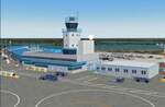
Founded as a gold town in 1936, Yellowknife is now the capital city of the Canadian Northwest Territories, and its airport, CYZF, is the busiest airport in northern Canada. Located only 250 miles south of the Arctic Circle, it is also subject to some of the harshest and most dangerous climate conditions in the world.
This version features:
*All ramps and taxiways completely redone to be more accurate
*All default buildings replaced
*Realistic Gmax models of the main terminal and tower, the First Air, CAF Squadron 440, and Buffalo Airways hangers
*Static aircraft for the First Air, CAF Squadron 440, Air Tindi and Buffalo Airways ramps
*Visual models of the arrestor cables on the main runway
*Fences, ramp lights, cargo, ground vehicles and all the other details that bring an airport to life
*Modular construction. The main buildings, ramp objects and static aircraft are in separate files and can be selectively deactivated to improve frame rates.
| Filename: | Yellowknife_CYZF_2010.zip |
| License: | Freeware |
| Added: | 16th January 2010, 10:31:02 |
| Downloads: | 6,892 |
| Author: | Sidney Schwartz, Peter Ham |
| Size: | 15.42 MB |
| Category: Flight Simulator 2004 - Scenery | |
| Torrejon Air Force Base (LETO), 1957-62 |
|
File Description:
Torrejón Air Base was originally the home of the Spanish National Institute of Aeronautics, but as a result of an agreement between Franco and the Unites States in 1953 an air base was created there with a large military apron and a runway 13,400 feet long - the longest in Europe for some decades. Officially opened in June 1957, both US bombers and fighters were based there, most significantly the B-47 Stratojet, which had too short a range to be operated only from the U.S. In July of 1958 the 497th Fighter Interceptor Squadron became the first permanently stationed Air Defence Group operating F-86L Sabres and from April 1960 the F-102 Delta Dagger. Over the years many different units and therefore many different aircraft types did TDY (Temporary Duty Assignments - usually 30-90 days) at Torrejon. Units of the Spanish Air Force were also present and are represented in this scenery package.
| Filename: | Torrejon_Air_Force_Base_LETO_195762.zip |
| License: | Freeware |
| Added: | 15th August 2021, 16:11:23 |
| Downloads: | 220 |
| Author: | Al Von Pingel and Ken Lawson |
| Size: | 44.81 MB |
| Category: Flight Simulator 2004 - Scenery | |
| Iloilo Airport ,Iloilo City, Philippines |
|
File Description:
Iloilo Airport is located in Iloilo City, Panay Island, Philippines. This local visayan airport is served by the following major domestic airlines: Philippine Airlines, Cebu Pacific and Air Philippines. This scenery features the most realistic replica of buildings located in the airport area such as the Main Terminal buildings, Control Tower, Crash and Fire Rescue Station, Philippine Air Force building, private hangars, shops, and commercial buildings including the SM City-Iloilo right in front of the airport area. SM City's parking area is generally filled with vehicles everyday that they are very visible at the ramp area of the airport at daytime and most especially visible glittering at nighttime.
This scenery also features the different commercial vessels serving Iloilo City such as WG&A Superferry, Sulpicio Lines, Negros Navigation, and Philippine Fastferry Corporation's Supercat and SeaAngels. These vessels are visible when flying from Iloilo to Bacolod City passing through the Guimaras Channel.
This scenery is designed with the combined efforts of Ver Walter Gulfan of Cebu City, Philippines and Manny Aquino of Surabaya, Indonesia. For suggestions or comments, please visit our Philippine Flightsimmers Group website at www.philskies.net or you may join our forum at www.philskies.net/forum.
RPVI AFCAD file included with aircrafts taking off at the middle of the runway!
| Filename: | Iloilo_Airport_Iloilo_City_Philippines.zip |
| License: | Freeware |
| Added: | 29th August 2003, 21:38:49 |
| Downloads: | 5,813 |
| Author: | Ver Walter Gulfan/Manny Aquino,Jr. |
| Size: | 5.83 MB |
| Category: Flight Simulator 2004 - Scenery | |
| Green Lake CBG2 in British Columbia Canada |
|
Images related to this file:
File Description:
Green Lake is on the eastern side of the Coast Mountains of British Columbia, around 40 miles north of Cache Creek and 15 miles south of 100 Miles House (a previous posting). The airfield is beside the lake shore and serves the Flying U holiday ranch with a grass runway 2,575 feet long and aligned 18-36. There is no lighting. There is also mooring on the lake for boats and float planes. I have posted it as Green Lake CBG2, but I suggest that you just add it to your previously created "BC airfields", if you followed my previous suggestion. You then avoid the inevitable doubling up of common textures etc. Plus that way you will have just one FS9 library post to do and new airfields will not need yet another posting. Up to you. It just occurred to me that probably only a few of you have a copy of the Nav Canada Airfields handbook, so won't know the airfield altitudes, which is useful to have amid mountains. So, Pemberton is 670 feet Above Sea Level, Cache Creek 2,034 feet ASL, and Green Lake 3,550 feet ASL. The others to follow as posted. If you find a defect, email me.
| Filename: | Green_Lake_CBG2_in_British_Columbia_Canada.zip |
| License: | Freeware, limited distribution |
| Added: | 18th November 2020, 19:44:00 |
| Downloads: | 85 |
| Author: | Roger Wensley |
| Size: | 10.05 MB |
| Category: Flight Simulator 2004 - Scenery | |
| Clyde River CYCY & Cape Christian in Nunavut Canada |
|
Images related to this file:
File Description:
Clyde River is a village on the northeast coast of Baffin Island, 250 miles above the Arctic Circle and around 150 miles north of Cape Hooper. It is on the shore of Patricia Bay at the entrance to Cylde Inlet, a fjord which stretches over 60 miles inland. The population is around 880 folks, and it was named by the explorer John Ross in 1818. The airfield is just east of the village and the lighted runway is 3,501' of 100' wide gravel at 87' ASL, aligned 018 True 198 True; "True" as opposed to magnetic in the Northern Domestic Airspace. There are two aprons, one with the new terminal building and one with the old terminal and the garage. Five miles northeast of Clyde River is Cape Christian, where there is a gravel runway around 3,000' long and adjacent to the beach, built to serve what was started as a weather station and later became a LORAN navigation system station. The station is still there, though it was closed some time ago and is now the subject of decontamination work. The runway is usable, though only for light planes as it is a bit rough. First Air and Canadian North are the AI planes visting Clyde River.
| Filename: | Clyde_River_CYCY__Cape_Christian_in_Nunavut_Canada.zip |
| License: | Freeware |
| Added: | 14th July 2011, 20:26:14 |
| Downloads: | 454 |
| Author: | Roger Wensley |
| Size: | 3.33 MB |
| Category: Flight Simulator 2004 - Scenery | |
| KQA Akutan, Alaska |
|
Images related to this file:
File Description:
This is Akutan, which comprises the water airport, the town, and the Trident crab and fish processing plant just to the west of the town. Akutan is in the Aleutians in an inlet on the island of the same name, around 35 miles ENE of Dutch Harbor, and is served by a Grumman Goose amphibian that flies from Dutch Harbor. The population is just over a thousand, though this can increase as more seasonal workers are employed at the plant. The church is not as big as it looks; the long part is a gymnasium. The Ai includes the Akutan end of a Grumman Goose flight from Dutch Harbour (the AI files are part of the Dutch Harbor scenery) which will take off from the Dutch Harbor runway and land on water at Akutan. It will then park at the bottom of the ramp up onto the apron, which is actually usable if you want to taxi up it. In reality it is a PenAir flight, here it is Reeve Aleutian for technical reasons. The Sea AI includes fishing boats from the Trident dock and a Coast Guard cutter from the town dock; the latter as explained in the updated version of Dutch Harbor, which you should already have installed.
| Filename: | KQA_Akutan_Alaska.zip |
| License: | Freeware, limited distribution |
| Added: | 10th August 2012, 16:54:02 |
| Downloads: | 492 |
| Author: | Roger Wensley + Sidney Schwartz |
| Size: | 3.17 MB |
| Category: Flight Simulator 2004 - Scenery | |
| El Dorado International Airport (SKBO) 2011 |
|
File Description:
El Dorado International Airport (IATA: BOG, ICAO: SKBO) is an international airport located in Bogota, Colombia. It is the largest Latin America airport in terms of cargo movements with 593,946 tons (2010) and the third in terms of
passenger traffic, only behind Sao Paulo-Guarulhos International Airport and Mexico City's Benito Juarez International Airport, transporting 18,934,203 passengers in 2010; as well as the largest airport in Colombia and the main
international and domestic air gateway in the country, serving as an important hub for Avianca, Copa Airlines Colombia, Aires, Satena, EasyFly and other cargo companies.
This file has the right coordinates, with the apron and characteristics of the airport. The runways were reoriented to the correct direction, runway were re-sized the gates placed on correct location and number, CATAM was placed
(Colombian Air force and Colombian National Army) and Colombia National Police and Colombian National Armada were assigned a correct apron. All the jet ways including the ones of the executive terminal are working. There is a copy
of all the airport charts required to navigate in and out of this airport which are courtesy of: Areonatica Civil de Colombia and the originals can be found at www.aerocivil.gov.co/ under Informacion Aeronautica click AIP; on AIP
click Aerodromos then click at SKBO.
| Filename: | El_Dorado_International_Airport_SKBO_2011.zip |
| License: | Freeware |
| Added: | 31st August 2011, 06:46:21 |
| Downloads: | 4,532 |
| Author: | Anwar Gonzalez |
| Size: | 14.34 MB |
© 2001-2026 AVSIM Online
All Rights Reserved
Privacy Policy |