
Where Flight Simulation Enthusiasts Gather from Around the World!
AVSIM Library - Search Results

| Category: Flight Simulator 2004 - Scenery | |
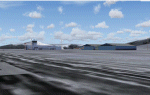
| Goodspeed Airport (42B) - East Haddam, Connecticut |

|
Images related to this file:
File Description:

Goodspeed is a privately owned airfield in East Haddam, Connecticut that operates as a public access general aviation facility. The runway is a short 2120 feet and is carefully placed in a shoreline meadow of the Connecticut river. Surrounded by the dense forests and community, the airport is a tight approach, further hampered by the presence of the East Haddam Bridge, which sits under the runway 14 approach. The airport has limited parking facilities for transient aircraft, and it is not common for visiting aircraft to park in the grass in front of the "terminal". Hanger facilities are provided as well. Nearby is the famous Goodspeed Opera House, established back in the 19th century, the house still has operas other performances regularly.
Features:
-High Resolution Ground textures around airport;
-Accurate models of all airport buildings;
-Detailed taxiways and runways;
-Super HD grass and pavement;
-Custom aerial imagery for area, including autogen;
-Full seasonal textures (Spring, Summer, Fall, Winter);
-Various "Easter Eggs";
-Deer (at dusk);
-Christmas Lights (During the Holiday Season);
-Night Textures;
-Runway Lights, obstruction lights;
-And much more!
Created by Dustin Mosher www.dmosher.info
| Filename: | Goodspeed_Airport_42B__East_Haddam_Connecticut.zip |
| License: | Freeware, limited distribution |
| Added: | 4th March 2010, 13:34:02 |
| Downloads: | 685 |
| Author: | Dustin Mosher |
| Size: | 62.8 MB |
| Category: Flight Simulator 2004 - Scenery | |
| EPMO - Modlin 2009 |
|
Images related to this file:
File Description:

EPMO MODLIN 2009 features an extremely detailed scenery of military airfield near Warsaw, Poland, fully compatible with FS2004. In the past it was a payware scenery, but Drzewiecki Design decided to provide you that old full product for FREE!
The airport was upgraded around 2012 and currently it has a nice passenger terminal and serves low-cost carriers like Ryanair, however back in 2009 it was an almost abandoned military airfield with some amazing structures inside. This scenery shows the status of Modlin airport in 2009 having many tumble-down buildings, deformed and rusty metal stairs and much more. Nothing has left of that old airport by now but using our scenery you can go back in time and check for yourself how it looked like.
The scenery features accurate positioning, modelling and texturing, high quality photoreal textures of all airport buildings (some buildings include interior) and high quality aerial photos of the airport. The package also includes charts and airfield specification.
The product is equipped with an automatic installer, but you need to manually add the airport into the Flight Simulator Scenery Library (see attached manual or read my text below). Please uninstall all previous versions of this airport you may have installed before. Please make also sure that no duplicate AFCAD files are installed.
Enjoy your virtual flying with Drzewiecki Design!
| Filename: | EPMO__Modlin_2009.zip |
| License: | Freeware, limited distribution |
| Added: | 2nd September 2015, 21:54:41 |
| Downloads: | 402 |
| Author: | Drzewiecki Design |
| Size: | 132.96 MB |
| Category: Flight Simulator 2004 - Scenery | |
| Elim ELI and Moses Point MOS in Alaska |
|
Images related to this file:
File Description:
Elim is a coastal village 90 miles east of Nome, living from fishing and with a population of around 330. The airfield has a gravel runway 3,000 feet long. The majority of flights to and from the airfield originate in Nome, but there are also others to and from nearby fields such as Golovin, Unalakleet, Shaktoolik, and Koyuk. A further 7 miles or so east of Elim is another field called Moses Point MOS, which is included here and was an Army Airforce field before being transferred to the private ownership of the Elim Native Corporation. Until Elim ELI was established (date unknown, but after 1988) this served the village of Elim and although the runway is now unlit and not in very good condition (translate that as "full of potholes") it is stated that the longer runway can still be used if Elim is not adequate. However, the note is undated and there are no details of how often it is used or even if it is actually still currently in use. There is one hangar still in existence; all the rest has been demolished and (mostly) removed. A note here about my scenery making. This is post number 502 and there will not be many more to follow this as I am almost at the end of the photos I either took or found for scenery purposes. There is a limit to what can be located online and I have already been making use of the little there is; eg Unalakleet. So, if you are near an airport (preferably Canadian or Alaskan) and have a camera..... Let me know.
| Filename: | Elim_ELI_and_Moses_Point_MOS_in_Alaska.zip |
| License: | Freeware, limited distribution |
| Added: | 2nd August 2019, 16:11:35 |
| Downloads: | 100 |
| Author: | Roger Wensley |
| Size: | 4.69 MB |
| Category: Flight Simulator 2004 - Scenery | |
| Fort Smith CYSM in Northwest Territories, Canada Revised |
|
Images related to this file:
File Description:
This is an updated version to remove an incomplete static Beaver reported by Graeme (thanks Cobber) and to include other modifications that I made for my own version since posting the original; different taxiway lights, revised aprons, and in particular the revised AI that I mentioned in the original 2011 post. This is complete and can be installed as-is, or used to modify an existing post by changing the original folder contents. Fort Smith is just north of the border between Alberta and Northwestern Territories, midway between Lake Athabasca to the southeast and Great Slave Lake to the north west. You might stop there when flying between Yellowknife or Hay River to La Ronge or Saskatoon. It looks as if it is ex-military and these are the remains of what were once 10,000 feet of asphalt runways. The main runway is now 11/29 and 6,000 feet long, and the secondary one is 1,800 feet of mostly gravel. There is an airline based at the field, Northwestern Air, and fuel is available at a self service point. The town of Fort Smith is two miles east of the airfield, on the bank of the Slave River and where there are some rapids that require a portage to get around them. Before aviation came along the river was a major route to the north and all those furry animals, which was why the Hudson's Bay Company established an outpost there in 1872. Today it has a population of 2,400 and the main activities are government administration of much of the Northwest Territories, education, and tourism.
| Filename: | Fort_Smith_CYSM_in_Northwest_Territories_Canada_Re.zip |
| License: | Freeware, limited distribution |
| Added: | 23rd January 2019, 19:14:44 |
| Downloads: | 143 |
| Author: | Roger Wensley |
| Size: | 7.16 MB |
| Category: Flight Simulator 2004 - Scenery | |
| NE USA Thermals |
|
File Description:
A set of thermals that comprehends all Territory of Vermont, New York,
Massachusetts, New Yersey, New Hampshire, Connecticut, Pennsylvania
and the area of Lake Ontario, Ottawa City included.
You can fly in a glider the whole area always finding thermals on your way.
| Filename: | NE_USA_Thermals.zip |
| License: | Freeware |
| Added: | 30th August 2005, 13:13:58 |
| Downloads: | 763 |
| Author: | Alejandro Villa |
| Size: | 2.57 MB |
| Category: Flight Simulator 2004 - Scenery | |
| Taal Volcano,Tagaytay, Philippines |
|
File Description:
This file will install The Taal Volcano at the middle of Taal Lake in FS2004 or in FS2002.
The shape of the island is based upon real aerial photographic maps.
Taal Volcano is located in the middle of Taal Lake in Tagaytay, Philippines.
| Filename: | Taal_VolcanoTagaytay_Philippines.zip |
| License: | Freeware |
| Added: | 28th November 2003, 16:04:39 |
| Downloads: | 1,928 |
| Author: | Ver Walter L. Gulfan |
| Size: | 5.35 KB |
| Category: Flight Simulator 2004 - Scenery | |
| Greenland |
|
Images related to this file:
File Description:
The island-continent of Greenland contains something more of 143 communities of them 88 are represented scenery presently.
14 airports and 5 helipads exist Alone they are inhabited their costs. especially the coast west.
Marine ports: kangerlusuaq,nanortalik,narsarsuak, Nuuk,and Sisimiut
| Filename: | Greenland.zip |
| License: | Freeware |
| Added: | 19th March 2010, 09:09:30 |
| Downloads: | 8,599 |
| Author: | Toni Agramont |
| Size: | 10.39 MB |
| Category: Flight Simulator 2004 - Scenery | |
| Alaska South Slope 3; Kiana PAIK |
|
Images related to this file:
File Description:
The town of Kotzebue is in the far northwest of Alaska, and served by Alaska Airlines. These are villages to the (mostly) east of Kotzebue on the South Slope of the Brooks Range of mountains, served by local flights from Kotzebue. There will be further additions. Kiana is a small village (population now around 360) on the bank of the Kobuk River, around 60 miles east of Kotzebue. The airfield, called Baker Memorial, is just north of the village, with 4,000 feet of lit gravel aligned 06-24 (as are several other runways in the area) with PAPI on 24. There are scheduled flights by Era (now renamed Ravn) and by Bering Air, both of them originating in Kotzebue and routing east to Noorvik, Kiana, Ambler, Shungnak, Kobuk, and then back again. The AI includes these flights along with Everts Air and Northern Air Cargo flights and GA. In real life the runway is around 200 yards closer to the village; this complicated the removal of roads and revised ground textures so I left it as is to make my life easier. The post includes missing night textures that were omitted from the post of Noatak PAWN. Noatak also has incorrectly installed original FS9 taxiway lights that were, as a result, impossible to remove. I had hoped to somehow manage it, but there is no way.
| Filename: | Alaska_South_Slope_3_Kiana_PAIK.zip |
| License: | Freeware, limited distribution |
| Added: | 7th September 2016, 22:00:17 |
| Downloads: | 212 |
| Author: | Roger Wensley |
| Size: | 4.5 MB |
| Category: Flight Simulator 2004 - Scenery | |
| Central Appalachia Land Class |
|
Images related to this file:
File Description:
I've used default textures (tiles) for villages MS left out of the sim. I didn't place all of the missing villages on the project sheet, though. I did not need to make custom tiles, neither. Most highways are connected the default villages now. I was satisfied with the default tiles MS uses. Most highways are connected the default villages now. Mountain ridge lines better contrast with valleys now. But, I did get it all...
| Filename: | Central_Appalachia_Land_Class.zip |
| License: | Freeware |
| Added: | 9th July 2015, 01:47:21 |
| Downloads: | 147 |
| Author: | Rick Connolly |
| Size: | 1.31 MB |
| Category: Flight Simulator 2004 - Scenery | |
| Hydroport |
|
File Description:
This is a neat little airport 30k appx. west of cyvr (Vancouver,B.C>). It has VOR, NDB, ILS, & ai ready parking. Also there is a hangar with movable doors operated by your radio on NAV 1. All the pertinent numbers for all of the above are in the readme file. There are also some boats just off shore. The town is Nanaimo. There are some LAGO sound files in another file I will upload shorty.
| Filename: | Hydroport.zip |
| License: | Freeware |
| Added: | 12th January 2006, 05:37:55 |
| Downloads: | 1,915 |
| Author: | Robert Lacy |
| Size: | 5.57 MB |
© 2001-2026 AVSIM Online
All Rights Reserved
Privacy Policy |