
Where Flight Simulation Enthusiasts Gather from Around the World!
AVSIM Library - Search Results

| Category: Flight Simulator 2004 - Scenery | |
| Scottsdale Airport KSDL |

|
File Description:
FS2004 Scenery-Scottsdale Airport (KSDL) is a general aviation reliever facility with no commuter or airline service, and is home to many corporate aircraft in the valley. Located 7 miles north of Scottsdale's downtown area, and in close proximity to a wide range of world class resorts, hotels, restaurants, and golf courses. Scottsdale Airport serves Scottsdale and Maricopa County and is owned by the City Of Scottsdale. The paved runway extends for 8251 feet. The facility is at an elevation of 1508 feet. Scenery created with FSDS2, Rwy12 and Lago's FSE. Requires AFCAD2 and Traffic Tools. Textures included.
| Filename: | Scottsdale_Airport_KSDL.zip |
| License: | Freeware |
| Added: | 7th October 2005, 23:24:07 |
| Downloads: | 1,605 |
| Author: | John B. Loney, Jr. |
| Size: | 2.56 MB |
| Category: Flight Simulator 2004 - Scenery | |
| Van Nuys Airport |
|
File Description:
FS2004 Scenery -Van Nuys Airport, CA (KVNY) serves Van Nuys and Los Angeles County and is owned by Los Angeles Dept Of Arpts. The airport has more than one runway. The longest is a runway extending 8001 feet. The facility is at an elevation of 799 feet at a distance of about 3 miles from Van Nuys. More than 100 businesses are located on the 730-acre airport, including six major fixed-base operators and numerous aviation service companies. Created with EZ Scenery. Choice of full version or Lite version. PLEASE READ THE README FILE FOR DETAILS! By John B. Loney, Jr.
| Filename: | Van_Nuys_Airport.zip |
| License: | Freeware, limited distribution |
| Added: | 1st July 2007, 20:50:44 |
| Downloads: | 3,078 |
| Author: | John B. Loney, Jr. |
| Size: | 1.06 MB |
| Category: Flight Simulator 2004 - Scenery | |
| Australian Lighthouses - Part 1 - Queensland |
|
File Description:
Around Australia's coastline there are over 350 lighthouses.
I received a suggestion a month ago asking if I would do the locations of the lighthouses down the coast of New South Wales and when I did a bit of research I thought, why not do the whole 36,735 kilometres around Australia?
So here is the first chapter - the lighthouses that dot the Queensland coast, from the tip of Cape York to the border at Coolangatta, about 30 in all.
Note that only the default Flight Simulator items are used; there is no requirement for any third-party objects.
| Filename: | Australian_Lighthouses__Part_1__Queensland.zip |
| License: | Freeware |
| Added: | 4th February 2006, 18:05:11 |
| Downloads: | 3,214 |
| Author: | Bruce Kennewell |
| Size: | 118.01 KB |
| Category: Flight Simulator 2004 - Scenery | |
| Real Landclass Manchester Airport and surrounding area |
|
File Description:
Real Landclass Manchester Airport Area for FS2004
In FS2004 the surrounding area of Manchester Airport (EGCC) is not realistic. The Aiport is surrounded by a huge
City. Rivers, Railways and Rivers that are around the airport do not exist.In realiy Manchester Airport is surrounded by a huge area
of fields, Highways and Rivers.
With this file you get the realistic landscape that is surrounding Manchester Airport, including Highways and Railways to and from the
Terminals and even the small river that flows from the north of the airport to the south of the airport passing RWY24L underground.
| Filename: | Real_Landclass_Manchester_Airport_and_surrounding_.zip |
| License: | Freeware |
| Added: | 30th June 2008, 23:43:59 |
| Downloads: | 4,952 |
| Author: | Dave Sheffield |
| Size: | 12.29 KB |
| Category: Flight Simulator 2004 - Scenery | |
| PAEN, PAEX, 3AK4, 30AK, 52AK - Alaska, USA |
|
Images related to this file:
File Description:
The town of Kenai is on the east coast of Cook Inlet, 60 miles southwest of Anchorage. The airport is in the northern part of the town, with a runway aligned 1-19, 7,550 feet long and 150 feet wide (with an ILS on 19). A second runway is gravel, 2,000 feet long and for winter use by ski planes. There is also a water runway, and all three are aligned the same and called "1 left-19 right" (the main runway) "1 right-19 left" (gravel) and "1 water-19 water". The taxiways are extensive and designed for a far larger traffic than the airport has today, though even now the airport is fairly busy. In FS9 a water runway for AI cannot work with an ATC control tower; the water part of PAEN has therefore been separated into another call sign PAEX which has ONLY the water runway; the tower will therefore direct the plane that makes contact to use the water runway. The PAEN airport runway has taxiway connections at each end and also two intermediates; at the northern end there are in fact two so a total of 5; B, C, D, E, and F; there is an airport diagram included. GA traffic goes to one of two parking aprons, both at the southern end, and at the far southern end there is the hangar for the Civil Air Patrol. The AI includes aircraft from my previous Alaska posts, as Kenai is where I sent them when they departed from, for instance, Palmer. Airlines and cargo companies that operate from and to Kenai are included in the AI: ERA (which has recently changed it's name), Grant Aviation, Air North, Wings of Alaska, North Star Air, and a small local company Air Supply Alaska, along with Fedex, UPS, Everts, and Northern Air Cargo. There is also GA and float AI. Nearby smaller airfields are included, partly because one of them was dramatically misaligned in FS9.
| Filename: | PAEN_PAEX_3AK4_30AK_52AK___Alaska_USA.zip |
| License: | Freeware, limited distribution |
| Added: | 26th December 2015, 15:33:19 |
| Downloads: | 482 |
| Author: | Roger Wensley |
| Size: | 23.08 MB |
| Category: Flight Simulator 2004 - Scenery | |
| Aspen (KASE), Colorado, Photo-Scenery (FS9 & FSX) |
|
Images related to this file:
File Description:
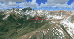
There sure is more than one reason to go to Aspen and this is sure another must-have of my Colorado sceneries. If you're coming IFR there's a couple of very demanding approach procedures. From a LOC/DME to several visual approaches there's everything your heart might desire. Due to the steep and high surrounding terrain these are quiet some hair raisers (see www.airnav.com/airport/KASE). If you're coming VFR then the traffic pattern altitude is 9.005 ft for light aircraft (vs. 9.505 for aircraft 12.500 lbs or more). Weather and wind permitting, RW15 is preferred for all landings (left pattern). RW33 has a right pattern and is preferred for all takeoffs. You even need a written permission to depart RW15. When departing VFR make a right turn to a heading of 360 degrees ASAP for noise abatement and hold this heading for at least 2 miles from the field. And don't forget to enjoy the impressive mountain scenery with two 14ers: Snowmass Mtn. and Castle Pk. to the southwest. This scenery brings you another 3.500 sq km of beautiful Colorado in 4.7m/pix quality. High resolution versions of this scenery for FS9 and FSX (much sharper, but larger and multiple downloads) are available at www.blueskyscenery.com/GNB_South2West2.html . The screenies are taken from the high-res versions, so expect this version to be slightly more blurry. YourDonation@Work: Dedicated to Mark, Markus and Yves.
| Filename: | Aspen_KASE_Colorado_PhotoScenery_FS9__FSX.zip |
| License: | Freeware, limited distribution |
| Added: | 30th January 2010, 17:04:55 |
| Downloads: | 3,578 |
| Author: | Gottfried Razek - blueskyscenery.com |
| Size: | 92.5 MB |
| Category: Flight Simulator 2004 - Scenery | |
| Quad City Intl. Airport |
|
File Description:
Quad City Intl. Airport in Moline IL. Features a custom made terminal for aircraft parking complete with jetways. Also included are an Afcad2 file (required for correct aircraft positioning at their respective gates and for correct ramp sizing), plus a set of custom flight plans for the airport. Please check the README FIRST.txt file for more information.
| Filename: | Quad_City_Intl_Airport.zip |
| License: | Freeware |
| Added: | 21st March 2004, 22:43:20 |
| Downloads: | 912 |
| Author: | Patrick Finch |
| Size: | 748.45 KB |
| Category: Flight Simulator 2004 - Scenery | |
| Invermere CAA8 in British Columbia, Canada |
|
Images related to this file:
File Description:
This airfield is in the Columbia Mountains (which are part of the Rockies) on the border between BC and Alberta. Invermere is in the same valley as Golden, 65 miles south and midway between Golden and Cranbrook. The town is at the northern end of Lake Windermere, on the western side, with a population of around 3,400. The main touristic feature of Invermere appears to be the provision of a wide choice of golf courses. These are included in the scenery, as are some of the surrounding commercial buildings including a nearby hotel and retail units. Invermere CAA8 is half a mile northeast of the lake, and is home to the non-profit Canadian Rockies Soaring Club that trains pilots during the summer months. The Invermere Soaring Centre, a separate organisation, provides glider towing services and rides for the general public. During the summer the airfield can only be described as busy, with gliders taking advantage of the terrain for ridge soaring. The AI here includes gliders that will take off and then circle around north of the field. The take off is not a realistic glider style launch, and the wind should be from the north; these gliders do not taxi and then turn around at the far end of a runway too well. Once again, like Golden, there is no runway or taxiway lighting, so daylight use only. There are GA visitors to CAA8 between the gliders, presumably carrying golfers and clubs. Due to the surrounding terrain AI aircraft might impact high ground before landing and then just show up on their parking spot.
| Filename: | Invermere_CAA8_in_British_Columbia_Canada.zip |
| License: | Freeware, limited distribution |
| Added: | 16th October 2018, 02:11:34 |
| Downloads: | 166 |
| Author: | Roger Wensley |
| Size: | 6.11 MB |
| Category: Flight Simulator 2004 - Scenery | |
| Madeira 76m SRTM Terrain Mesh |
|
File Description:
USGS SRTM 3 arc-second, resampled to LOD9 (76 meters).
This is a terrain mesh scenery of the Island of Madeira west of Morocco, Africa.
Included are the islands of Madeira and Porto Santo.
| Filename: | Madeira_76m_SRTM_Terrain_Mesh.zip |
| License: | Freeware, limited distribution |
| Added: | 4th April 2004, 16:48:40 |
| Downloads: | 13,099 |
| Author: | Andreas Trawny |
| Size: | 522.21 KB |
| Category: Flight Simulator 2004 - Scenery | |
| NZMJ Martins Bay, New Zealand |
|
Images related to this file:
File Description:
Fiordland, New Zealand. 19nm from Milford Sound. You must have Christian Stock's NZ mesh in the form of "Mountains of New Zealand"
and topo in the form of "Lakes and Rivers of New Zealand".
| Filename: | NZMJ_Martins_Bay_New_Zealand.zip |
| License: | Freeware |
| Added: | 13th July 2010, 09:19:02 |
| Downloads: | 359 |
| Author: | Godfrey Tier |
| Size: | 855.99 KB |
© 2001-2026 AVSIM Online
All Rights Reserved
Privacy Policy |