
Where Flight Simulation Enthusiasts Gather from Around the World!
AVSIM Library - Search Results

| Category: Flight Simulator 2004 - Scenery | |
| FA2004 Scenery - Des Moines Intl KDSM |

|
Images related to this file:
File Description:
Re-upload. FS2004 Scenery-The Des Moines International Airport (KDSM) is owned and operated by the City of Des Moines . The Airport (IATA: DSM, ICAO: KDSM) is a commercial airport located in the southern part of the city of Des Moines, Iowa USA. The airport serves residents of the Des Moines metropolitan area and is the closest airport with connections to major airline hubs for people who live throughout much of east-central, north-central, and southern Iowa. The 132d Fighter Wing of the Iowa Air National Guard is located at the Des Moines International Airport. This scenery was created solely with Rwy12 and Lago's FSE. The AFCAD2 file has been modified and is included in the download. Readme file important, please read. By John B. Loney, Jr.
| Filename: | FA2004_Scenery__Des_Moines_Intl_KDSM.zip |
| License: | Freeware, limited distribution |
| Added: | 6th June 2010, 09:41:45 |
| Downloads: | 4,053 |
| Author: | John B. Loney, Jr. |
| Size: | 464.22 KB |
| Category: Flight Simulator 2004 - Scenery | |
| Shepherd Bay CWSB in Nunavut, Canada |
|
Images related to this file:
File Description:
This was a DEW line Auxiliary Station on the western shore of the lower reaches of the Boothia Peninsula, 50 miles south of Taloyoak and 60 miles east of Gjoa Haven. The station was closed in 1989 but is almost intact except for a diesel tank or two. There are also other buildings nearby, and others on the beach landing area. A NWS automated station was opened in the same year as the Dew station was closed. The runway is also still there and is around 4,500 feet of gravel 100' wide, aligned 027T/207T. There are no lights, signage, or windsock, but the usual large hangar which was built at all Auxiliary Stations still survives. This is one of the more interesting DEW line stations to visit and walk around.
| Filename: | Shepherd_Bay_CWSB_in_Nunavut_Canada.zip |
| License: | Freeware, limited distribution |
| Added: | 22nd November 2012, 16:28:45 |
| Downloads: | 222 |
| Author: | Roger Wensley |
| Size: | 2 MB |
| Category: Flight Simulator 2004 - Scenery | |
| Whati CEM3 in the Northwest Territories, Canada |
|
Images related to this file:
File Description:
Whati is a village at the southern end of Lac La Martre, a smaller lake (only by Canadian standards, at over 40 miles long) halfway between the Great Slave Lake and the Great Bear Lake and around 100 miles north of Yellowknife. The North West Company established a trading post there in 1793, and this was the centre for local trading in the area for 100 years until a post was opened by the Hudson Bay Company on the Great Slave Lake. The current population is in the region of 520. There is no graded road access and access is by boat or air. The main local economy revolves around hunting and fishing, with efforts being made to increase tourism amid the wilderness and the wildlife. The airfield is just over a mile east of the village, with a runway of around 3,400 feet of gravel aligned 09-27 as of 2010, with PAPI at both ends and lit. There are scheduled flights from Yellowknife by Air Tindi, included in the AI, and some GA. The terminal building is similar to that of Lutselk'e, but with a different colour scheme and with solar panels on the roof. It appears that they repaint the sign on the front of the building with a different wording every time; the one I have used is one of three that have existed in the last few years. The photos I had originally were taken in the winter, with snow. Seeing it in the summer I discovered that my version of the building is not at the right level above the ground by about a foot, or 30cm. I was too lazy to make it again, which was the only way to get it right and still have it throw a shadow on the ground. This scenery modifies the lake shore, corrects levels for land and lake, and adds the village and a connecting road in addition to the airport. A note here about my scenery making. There will not be many more to follow this as I am almost at the end of the photos I either took or found for scenery purposes, plus I expect to move on from FS9 at some point during next year.
| Filename: | Whati_CEM3_in_the_Northwest_Territories_Canada.zip |
| License: | Freeware, limited distribution |
| Added: | 15th December 2019, 19:18:29 |
| Downloads: | 148 |
| Author: | Roger Wensley |
| Size: | 4.25 MB |
| Category: Flight Simulator 2004 - Scenery | |
| VABJ Bhuj Rudra Mata Air Force Base |
|
File Description:
Fully loaded airport as of 2013 with four gates, lots of trees vehicles, lots of hangers and static aircraft.
| Filename: | VABJ_Bhuj_Rudra_Mata_Air_Force_Base.zip |
| License: | Freeware |
| Added: | 29th April 2013, 06:53:45 |
| Downloads: | 350 |
| Author: | ladhani ramesh |
| Size: | 22.27 KB |
| Category: Flight Simulator 2004 - Scenery | |
| Colorado Lakes Project II |
|
File Description:
This project features the Blue Mesa Reservoir and the Black Canyon of the Gunnison and adds over 300 highly detailed lakes to the central portion of western Colorado. Three reservoirs, named for corresponding dams on the Gunnison River, form the heart of Curecanti National Recreation Area. Panoramic mesas, fjord-like reservoirs, and deep, steep and narrow canyons abound. Blue Mesa Reservoir is Colorado's largest body of water, and is the largest Kokanee Salmon fishery in the United States. Morrow Point Reservoir is the beginning of the Black Canyon of the Gunnison and below it is Crystal Reservoir.
These lakes are specifically designed to show off their photo realistic detail when used in combination with "FSGenesis-The Rockies 38.2m Terrain Mesh-Colorado" available as "fsg_dem38m_usrk_co.zip" at avsim.com, or comparable mesh. The free FSGenesis US National Landclass Project Beta 6 also adds beautifully to the landscape. These lakes work equally as well with the default mesh.
All lake information was projected from satellite imagery and compiled with a beta version of Jim Keir's "Slartibartfast" utility. Much thanks to Holger Sandmann and Jim Keir for their help and advice on interpreting the satellite data properly.
| Filename: | Colorado_Lakes_Project_II.zip |
| License: | Freeware |
| Added: | 1st June 2004, 02:34:42 |
| Downloads: | 6,050 |
| Author: | Carlyle Sharpe |
| Size: | 332.25 KB |
| Category: Flight Simulator 2004 - Scenery | |
| CYEN Estevan Saskatchewan Municipal Airport |
|
Images related to this file:
File Description:

CYEN Estevan Municipal airport is situated approximately three miles (6 Km) north of the City of Estevan. CYEN Estevan Muni was constructed using GMAX and represents the airport as it was in the Summer of 2006. It includes all the buildings at the airport, runway signs, addition of some fencing, anda new rotating beacon that is closer to the actual device. CYEN also includes a landclass file to better represent the terrain around the airport, at least as far as the limits of the default landscape will allow.
The airport is home to Sunrise Aviation (which operates the field for the city) and some 26 light aircraft. CYEN handles a wide variety of Canadian and U.S. corporate and charter aircraft given the large oil and coal mining industry in the area. With the U.S. border so close by, CYEN is also the first stop for many U.S. registered aircraft that land to clear customs and refuel.
(This is a re-upload of the scenery to replace the original that was lost in the AVSIM hack. No changes have been made)
| Filename: | CYEN_Estevan_Saskatchewan_Municipal_Airport.zip |
| License: | Freeware |
| Added: | 7th May 2010, 12:47:13 |
| Downloads: | 1,700 |
| Author: | Gregory Putz |
| Size: | 1.67 MB |
| Category: Flight Simulator 2004 - Scenery | |
| Kanab (KKNB), Utah/Arizona, Photo-Scenery (FS9 & FSX) |
|
Images related to this file:
File Description:
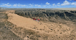
This scenery covers the southwestern part of Grand Staircase-Escalante National Monument. From the air
you can see all the "stairs" from the Pink Cliffs of Bryce Canyon in the north down to the Grey Cliffs,
the White Cliffs and the Vermillion Cliffs just north of Kanab and then the Chocolate Cliffs further south.
Nothwest of Kanab you can fly above beautiful Coral Pink Sand Dunes State Park which features coral-hued
sand dunes located beside red sandstone cliffs. These dunes consist of sand that formed thru erosion of
pink colored Navajo Sandstone surrounding the park and was deposited by wind. To explore the scenery depart
from Kanab Airport (KKNB).
High resolution versions of this scenery for FS9 and FSX (much sharper, but larger and multiple downloads)
are available at www.blueskyscenery.com/CNY_South3West4.html . The screenies are taken from the high-res versions,
so expect this version to be slightly more blurry. Thanks to Joop Mak for providing custom AFCADs that
correct airport layouts so that they align with the photo-textures! They are available at
www.blueskyscenery.com/AFCADs.html . YourDonation@Work: Dedicated to Jesper, Fabrizio and Glen.
| Filename: | Kanab_KKNB_UtahArizona_PhotoScenery_FS9__FSX.zip |
| License: | Freeware, limited distribution |
| Added: | 10th March 2010, 22:24:53 |
| Downloads: | 1,506 |
| Author: | Gottfried Razek - blueskyscenery.com |
| Size: | 95.36 MB |
| Category: Flight Simulator 2004 - Scenery | |
| FS2004 Scenery World War II Naval Air Stations. |
|
Images related to this file:
File Description:
FS2004 Scenery--World War II Naval Air Stations. Leading up to the Second World War, the United States pursued a rush building program for airship bases. These bases were designed to support fleets of blimps that would patrol its coasts and help protect its vulnurable shipping lanes. Together these bases boasted fourteen airdocks which are widely believed to be the largest free-standing wooden buildings ever constructed. Although time and misfortune have destroyed most of them, this scenery will bring them back in their heyday of the early 1940's. This scenery package contains all eight of these wartime Naval Air Stations; Weeksville, North Carolina (NC), Hitchcock, Texas (TX), Glynco, Georgia (GA), Santa Ana, California (CA), Richmond, Florida (FL), Houma, Louisiana (LA), South Weymouth, Massachusetts (MA), and Tillamook, Oregon (OR). As a bonus for your patience you will also find the seaplane base at Tongue Point OR and a custom scenery addon package of ground crews and vintage vehicles. This is a stand alone scenery package and requires the removal of any and all previous versions. Re-upload of previous file due to library hack. By John Stinstrom.
| Filename: | FS2004_Scenery_World_War_II_Naval_Air_Stations.zip |
| License: | Freeware, limited distribution |
| Added: | 27th May 2010, 09:37:53 |
| Downloads: | 903 |
| Author: | John Stinstrom |
| Size: | 11.09 MB |
| Category: Flight Simulator 2004 - Scenery | |
| 1962 and 1965 Tokyo Haneda Airport Scenery |
|
File Description:
This scenery represents the international airport of Tokyo in the 1960's, Haneda. This package also removes the modern airport of Narita. There are two versions of the airport in this package, 1962 and 1965. Today, Tokyo International Airport (known to locals as Haneda) is consistently among the five busiest airports in the world. In the early 1960s, it was the only international airport serving the economic recovery of the Japanese capital. The entire airport was upgraded extensively between 1961 and 1964 in preparation for the Tokyo Olympics in October of '64. By 1965, a longer runway 15/33, expanded terminal, and improved ground transportation links were all in use at Haneda (these changes are reflected in the '62 and '65 versions). Terminal and ground details by Aaron Seymour, JAMCO/JAL hangars and AFCAD files by Tom Gibson. Thanks to Wolfgang Gersch for the parking area.
| Filename: | 1962_and_1965_Tokyo_Haneda_Airport_Scenery.zip |
| License: | Freeware, limited distribution |
| Added: | 5th October 2008, 20:43:08 |
| Downloads: | 3,844 |
| Author: | Aaron Seymour and Tom Gibson |
| Size: | 1.04 MB |
| Category: Flight Simulator 2004 - Scenery | |
| Torrey, Box-Death Hollow Wilderness, Aquarius Plateau, Utah, Photo-Scenery (FS9 & FSX) |
|
Images related to this file:
File Description:
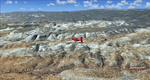
The southern part of this region covers the Box-Death Hollow Wilderness, with its vertical gray-orange walls of Navajo sandstone. Then comes the Aquarius Plateau which is the highest timbered plateau in North America with Boulder Mountain. In the north you'll find the little town of Torrey, which is just eight miles west of Capitol Reef National Park. Extends my Grand Staircase Escalante scenery to the north.
High resolution versions of this scenery for FS9 and FSX (much sharper, but larger and multiple downloads) are available at www.blueskyscenery.com/CNY_SouthWest3.html . The screenies are taken from the high-res versions, so expect this version to be slightly more blurry.
Thanks to Joop Mak for providing a custom AFCADs that correct airport layouts so that they align with the photo-textures! They are available here: www.blueskyscenery.com/AFCADs.html . YourDonation@Work: Dedicated to Ralf-Peter, Jon and Laurent.
| Filename: | Torrey_BoxDeath_Hollow_Wilderness_Aquarius_Plateau.zip |
| License: | Freeware, limited distribution |
| Added: | 3rd April 2010, 00:52:09 |
| Downloads: | 1,202 |
| Author: | Gottfried Razek - blueskyscenery.com |
| Size: | 93.79 MB |
© 2001-2026 AVSIM Online
All Rights Reserved
Privacy Policy |