
Where Flight Simulation Enthusiasts Gather from Around the World!
AVSIM Library - Search Results

| Category: Flight Simulator 2004 - Scenery | |
| Placerville Airport (KPVF) California |

|
File Description:
This is a scenery upgrade for Placerville Airport, California (KPVF). This is part Four of a series of small airstrip and minor airfield scenery enhancements which are based on real world data from Google Earth (Not this one though, Google earth did not have a detailed image of KPVF so I had to use what was available on the net, which was not much!). Built using EZ_Scenery, Lee Swordy's AFCAD and SBuilder. You must have rwy12 and EZ scenery libraries installed for the buildings to show. Both libraries of objects are free. EZ Library is available from this URL http://www.abacuspub.com/pub/AbacusEZLibraries.exe. Rwy12 from Avsim and additional EZ Custom libraries from Avsim also. Search under Scenery design.
| Filename: | Placerville_Airport__KPVF_California.zip |
| License: | Freeware |
| Added: | 21st March 2006, 23:26:12 |
| Downloads: | 641 |
| Author: | Kim Gowney |
| Size: | 242.76 KB |
| Category: Flight Simulator 2004 - Scenery | |
| Grand Staircase Escalante National Monument/East, Escalante (1L7), Utah, Photo-Scenery (FS9 & FSX) |
|
Images related to this file:
File Description:
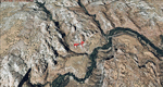
This scenery contains the eastern part of the Grand Staircase Escalante National Monument. It extends from the town of Escalante down south where it connects with the Page/Lake Powell scenery. Contains the upper part of wonderful Escalante Canyon. To explore the scenery depart from Escalante Airport (1L7). Thanks to Joop Mak for providing a custom AFCAD that corrects the airport layout so that it matches with the photo-textures! High resolution versions of this scenery for FS9 and FSX (much sharper, but larger and multiple downloads) are available at www.blueskyscenery.com/CNY_South2West3.html . The screenies are taken from the high-res versions, so expect this version to be slightly more blurry. YourDonation@Work: Dedicated to Jay, Donald and Franz
| Filename: | Grand_Staircase_Escalante_National_MonumentEast_Es.zip |
| License: | Freeware, limited distribution |
| Added: | 4th March 2010, 22:44:30 |
| Downloads: | 1,486 |
| Author: | Gottfried Razek - blueskyscenery.com |
| Size: | 96.2 MB |
| Category: Flight Simulator 2004 - Scenery | |
| CYOC - Old Crow - Yukon Territory, Canada |
|
Images related to this file:
File Description:
Old Crow is in the far north of the Yukon Territory, Canada, 115 miles south of the nearest coastline and 30 miles east of the border with Alaska. The town has a population of less than 300 and the population are reliant on the caribou migration for an annual food supply replenishment. The fact that it is the only Yukon town that cannot be reached by car makes the airport important, and there are regular flights by Air North, the Yukon airline. They are included in the AI along with GA aircraft. I had several tries at matching up the Hawker Siddeley 748 with the right set of textures and I have included both here so that you do not have to go through the same torture. Thanks go to Hernan for sorting all that out, and for his textures. The airport is beside the town that is built along a bank of the Porcupine River. I have replicated the current shore line of the river that has cut a new channel at one end of the town, and I flattened the river as it was somewhat mountainous. The runway is gravel and just over 5,000 feet long, aligned 03-21. The terminal building is specific to Old Crow as I had photos, but the hangars are approximations and the village houses are only representational.
| Filename: | CYOC__Old_Crow__Yukon_Territory_Canada.zip |
| License: | Freeware, limited distribution |
| Added: | 5th December 2014, 13:31:46 |
| Downloads: | 370 |
| Author: | Roger Wensley |
| Size: | 7.58 MB |
| Category: Flight Simulator 2004 - Scenery | |
| USS Langley relocation to British Columbia -- 2 locations |
|
File Description:
These files relocate the USS Langley of the MAAM Avenger package into the waters of British Columbia, Canada.
CVL48 is located South of Victoria Harbour (CYWH) and North of Port Angeles (KNOW), Washington in the Strait of Juan de Fuca.
CVL49 is located NW of Vancouver (CYVR) in the Strait of Georgia.
| Filename: | USS_Langley_relocation_to_British_Columbia__2_loca.zip |
| License: | Freeware, limited distribution |
| Added: | 10th August 2008, 09:16:39 |
| Downloads: | 1,200 |
| Author: | Brent Hricziscse and Bill Dick |
| Size: | 1.82 MB |
| Category: Flight Simulator 2004 - Scenery | |
| ETND - Diepholz AB - Bremen, Germany |
|
Images related to this file:
File Description:
Diepholz Airbase is the home of Luftwaffenversorgungsregiment 2 of the German Airforce and although the home of Flugplatz Diepholz-Duemmerland southwest of Bremen.
| Filename: | ETND__Diepholz_AB__Bremen_Germany.zip |
| License: | Freeware |
| Added: | 10th September 2015, 17:25:50 |
| Downloads: | 682 |
| Author: | David Kolas |
| Size: | 2.93 MB |
| Category: Flight Simulator 2004 - Scenery | |
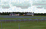
| Murfreesboro Municipal - KMBT |
|
Images related to this file:
File Description:
FS2004 Scenery-Murfreesboro Municipal Airport (KMBT) serves Murfreesboro and Rutherford County and is owned by the City Of Murfreesboro. The paved runway extends for 3898 feet. The facility is at an elevation of 615 feet at a distance of about 2 miles from Murfreesboro. Created entirely with EZ Scenery. EZ Scenery library objects required. New AFCAD file and AI traffic from Traffic Tools included. By John B. Loney, Jr.
| Filename: | Murfreesboro_Municipal__KMBT.zip |
| License: | Freeware, limited distribution |
| Added: | 3rd June 2010, 00:43:34 |
| Downloads: | 817 |
| Author: | John B. Loney, Jr. |
| Size: | 1.09 MB |
| Category: Flight Simulator 2004 - Scenery | |
| Wombat Bend |
|
File Description:
Wombat_Bend, a fictional scenery set in Lake Eildon, Victoria, Australia, a short Dirt Bush Strip on the side of one of the lakes with buildings and wharf for those that choose to fly in via Sea Plane. Night lighting and buildings. Location provided with attached map.jpg .
Has a nice approach from either direction with plenty of trees to avoid on the way in.
Uses Default textures with Custom textures where required.
| Filename: | Wombat_Bend.zip |
| License: | Freeware |
| Added: | 11th October 2003, 05:30:59 |
| Downloads: | 848 |
| Author: | Jeffrey Stanyer |
| Size: | 272.7 KB |
| Category: Flight Simulator 2004 - Scenery | |
| Pensford Railway Viaduct - Somerset UK |
|
File Description:
Fully tested in FS2004. Designed to work with VFR Photo Scenery & VFR Terrain by Get Mapping / Visual Flight
Pensford (Somerset) can be found 13 miles south of the City of Bristol and close to Stanton Drew (See Stanton Drew Standing Stones FS2004) N51 22.24 W2 33.09
Built in 1873 for the Railway from Bristol to Radstock. The viaduct has 16 arches, spaning a total of 303.27m and is 28.96m high.
| Filename: | Pensford_Railway_Viaduct__Somerset_UK.zip |
| License: | Freeware |
| Added: | 13th October 2005, 23:03:22 |
| Downloads: | 1,519 |
| Author: | Justin Wilmott |
| Size: | 139.55 KB |
| Category: Flight Simulator 2004 - Scenery | |
| Masterton, New Zealand |
|
File Description:
NZMS - Hood Aerodrome - Masterton - New Zealand.
For FS2004.
Made to fit Christian Stock's NZ 20-mesh and Topo;
aka. "Mountains of New Zealand" and "Roads and Rivers of New Zealand".Don't know what it would be like with the 75-mesh - probably hopeless with default scenery.
This is not meant to be accurate, but is a fairly true representation.
It's meant to give you the "feel" of being there.
| Filename: | Masterton_New_Zealand.zip |
| License: | Freeware |
| Added: | 4th July 2008, 23:35:17 |
| Downloads: | 502 |
| Author: | Godfrey Tier |
| Size: | 2.49 MB |
| Category: Flight Simulator 2004 - Scenery | |
| Red Wing Regional KRGK |
|
File Description:
FS2004 Scenery - Red Wing Municipal Airport (KRGK) serves Red Wing and Pierce County and is owned by the City Of Redwing. The paved runway extends for 4002 feet. The facility is at an elevation of 785 feet at a distance of about 3 miles from Red Wing. Red Wing is physically in Wisconsin, but is listed, with the FAA, in Minnesota, USA. Created with Instant Scenery by John b. Loney, Jr.
| Filename: | Red_Wing_Regional_KRGK.zip |
| License: | Freeware, limited distribution |
| Added: | 17th February 2009, 17:53:25 |
| Downloads: | 599 |
| Author: | John B. Loney, Jr. |
| Size: | 7.54 MB |
© 2001-2026 AVSIM Online
All Rights Reserved
Privacy Policy |