
Where Flight Simulation Enthusiasts Gather from Around the World!
AVSIM Library - Search Results

| Category: Flight Simulator 2004 - Scenery | |
| Zion National Park South, Hurricane (1L8), Colorado City (KAZC), Utah/Arizona, Photo-Scenery (FS9 & FSX) |

|
Images related to this file:
File Description:
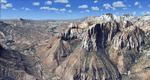
Covers the southern part of Zion National Park extends south along the cities of Hurricane and Colorado City. Zion National Park is another place where erosion of the Colorado Plateau formed the most beautiful colorful stone formations of unique and wonderful shapes. There are nine different layers of stone visible in the park. Most of them consist of sandstone. But there is also limestone, gypsum, siltstone, shale, clay and mudstone. The Virgin River cut a spectacular and famous canyon thru Zion Park that is as narrow as 20ft and up to 2000ft tall.
High resolution versions of this scenery for FS9 and FSX (much sharper, but larger and multiple downloads)
are available at www.blueskyscenery.com/CNY_South3West5.html . The screenies are taken from the high-res versions,
so expect this version to be slightly more blurry. Thanks to Joop Mak for providing custom AFCADs that
correct airport layouts so that they align with the photo-textures! They are available at www.blueskyscenery.com/AFCADs.html . YourDonation@Work: Dedicated to Jerry, Ralph J. and Lance.
| Filename: | Zion_National_Park_South_Hurricane_1L8_Colorado_Ci.zip |
| License: | Freeware, limited distribution |
| Added: | 20th March 2010, 23:26:42 |
| Downloads: | 1,784 |
| Author: | Gottfried Razek - blueskyscenery.com |
| Size: | 95.39 MB |
| Category: Flight Simulator 2004 - Scenery | |
| Parry Sound Harbour CPS1 in Ontario REPOST |
|
File Description:
This is a repost of yesterday's post of the Parry Sound Harbour as it seems one of the files didn't make it through the upload intact. Parry Sound Harbour float base is at the mouth of the Seguin River, where it flows into Parry Sound and Georgian Bay on Lake Huron, 110 miles north of Toronto. The base is run by Georgian Bay Airways Ltd who in 2006 were operating a Beaver and a Cessna 180, if I am remembering that right; the Beaver for sure. There is fuel and oil available, and food! This version has the modelled version of the float base building, after three years.
| Filename: | Parry_Sound_Harbour_CPS1_in_Ontario_REPOST.zip |
| License: | Freeware |
| Added: | 17th February 2009, 00:26:11 |
| Downloads: | 682 |
| Author: | Roger Wensley |
| Size: | 1.88 MB |
| Category: Flight Simulator 2004 - Scenery | |
| CWGP- Gladman Point - Nunavut, Canada |
|
Images related to this file:
File Description:
This is a DEW line Auxiliary Station on the south shore of King William Island; the island is around 70 miles square and Gjoa Haven is on the southeast corner. The station was closed in 1992 and has now been totally dismantled and removed, a pollutant hazard for the inhabitants of Gjoa Haven. The runway is still there and is a shade over 5,000 feet of gravel 150' wide. There are no lights, signage, or windsock, and in this case even the hangar has gone. A North Warning System station was built in 1990 on a small part of the site of the DEW Station, north of the runway.
| Filename: | CWGP_Gladman_Point__Nunavut_Canada.zip |
| License: | Freeware, limited distribution |
| Added: | 18th November 2012, 09:21:52 |
| Downloads: | 206 |
| Author: | Roger Wensley |
| Size: | 1.23 MB |
| Category: Flight Simulator 2004 - Scenery | |
| Australian Lighthouses - Part 5 - South Australia |
|
File Description:
Around Australia's coastline there are over 350 lighthouses.
I received a suggestion a month ago asking if I would do the locations of the lighthouses down the coast of New South Wales and when I did a bit of research I thought, why not do the whole 36,735 kilometres around Australia?
Here is Part 5 - the lighthouses located on the coastline of State of South Asutralia.
Some installations no longer exist but I included them for those of us who like historical and period flying. If it was there in 1935, it's there in this package!
A Read Me file is included. No third-party content is required.
| Filename: | Australian_Lighthouses__Part_5__South_Australia.zip |
| License: | Freeware |
| Added: | 9th February 2006, 15:18:18 |
| Downloads: | 2,485 |
| Author: | Bruce Kennewell |
| Size: | 127.72 KB |
| Category: Flight Simulator 2004 - Scenery | |
| Australian Lighthouses - Part 4 - Tasmania |
|
File Description:
Around Australia's coastline there are over 350 lighthouses.
I received a suggestion a month ago asking if I would do the locations of the lighthouses down the coast of New South Wales and when I did a bit of research I thought, why not do the whole 36,735 kilometres around Australia?
Here is Part 4 - the lighthouses located around the coastline of the island State of Tasmania.
Some installations no longer exist but I included them for those of us who like historical and period flying. If it was there in 1935, it's there in this package!
A Read Me is included. No third-party items are required.
| Filename: | Australian_Lighthouses__Part_4__Tasmania.zip |
| License: | Freeware |
| Added: | 7th February 2006, 01:56:36 |
| Downloads: | 2,399 |
| Author: | Bruce Kennewell |
| Size: | 127.44 KB |
| Category: Flight Simulator 2004 - Scenery | |
| Nikolski (IKO), Nelson Lagoon (Z73), & Perryville (AK5) - Alaska, USA |
|
Images related to this file:
File Description:
These are villages in Alaska, spread out east and west of Dutch Harbor in the Aleutians and the peninsula, served by Grant Aviation regional flights from Dutch Harbor, Cold Bay, or King Salmon.
Nikolski is 115 miles west of Dutch Harbor at the western end of Umnak Island, which is just west of Unalaska, the large island adjacent to Dutch Harbor. Nikolski is small, with a population of perhaps only 20 now, and the main claim to fame is the wrecked Reeve Aleutian DC3 at the end of the runway. The runway is 3,500 feet of gravel aligned 08-26. Nelson Lagoon is on the north shore of the peninsula, 55 miles north of Sand Point and on a long spit of land that curves around to make the lagoon. There is no access except by boat or plane for the population of around 50. The airfield is a mile east of the village with a gravel runway 08-26, 4,000 feet long. Perryville is on the south shore of the peninsula, 65 miles east of Sand Point. The population is around 115, and the airfield is southwest of the town with the 3,500 feet of gravel runway aligned 02-20 beside the shore. There is a hangar on the apron, but no terminal building.
| Filename: | Nikolski_IKO_Nelson_Lagoon_Z73__Perryville_AK5__Al.zip |
| License: | Freeware, limited distribution |
| Added: | 14th March 2015, 13:27:53 |
| Downloads: | 255 |
| Author: | Roger Wensley |
| Size: | 11.45 MB |
| Category: Flight Simulator 2004 - Scenery | |
| Storck Barracks Illesheim |
|
Images related to this file:
File Description:

The third scenery designed by Brian Clarke, this is a representation of the first European base of the McDonnell Douglas AH-64A Apache.
Illesheim Airfield was built by the Germans as a part of their illegal air force expansion during the 1930s, and was used extensively during world war 2 by the Luftwaffe.
The USAAF, and subsequently the US Army, have resided at the base since 1945, and the first Apaches of the 2nd Squadron, 6th Cavalry arrived in 1986.
The Apache repaints represent the aircraft of 2-6 during 1990, but the base could be used in a modern environment as it is still in use.
Also included are repaints for Nick Blacks AI AH-64 for use at the base.
| Filename: | Storck_Barracks_Illesheim.zip |
| License: | Freeware, limited distribution |
| Added: | 22nd January 2013, 21:44:22 |
| Downloads: | 763 |
| Author: | Brian Clarke, Stewart Pearson, Daryl Payne |
| Size: | 5.2 MB |
| Category: Flight Simulator 2004 - Scenery | |
| CNU8 - Toronto - Markham Airport (2008), Ontario, Canada |
|
Images related to this file:
File Description:
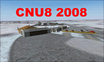
CNU8 - Toronto - Markham Airport (2008) - Markham v1. The airport is owned and operated by Markham Airport Inc., and is not part of the Greater Toronto Airport Authority.
The airport consists of a single 2,000 foot runway for small and private aircraft only (with night flying capabilities). The Royal Canadian Air Cadets Gliding Program uses the north side or the runway 09/27 for glider operations in the spring and fall months, and use a northern traffic pattern. This airport may disappear with the establishment of a planned Pickering Airport or re-location of Toronto/Buttonville Municipal Airport.
(This is a re-upload of the scenery to replace the original that was lost in the AVSIM hack. No changes have been made)
| Filename: | CNU8__Toronto__Markham_Airport_2008_Ontario_Canada.zip |
| License: | Freeware, limited distribution |
| Added: | 16th May 2010, 10:06:40 |
| Downloads: | 1,588 |
| Author: | Keith Murphy |
| Size: | 5.24 MB |
| Category: Flight Simulator 2004 - Scenery | |
| Bandirma LTBG 2010 - Turkey Public/Military Airport |
|
Images related to this file:
File Description:
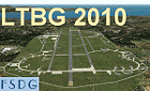
Realistic represantation of current LTBG Bandirma Civillian/Military airport with the AI Traffic flightplans. A must have scenery for FS, both for offline and online/VFR and IFR flights. This scenery is for FsX and Fs2004.
| Filename: | Bandirma_LTBG_2010__Turkey_PublicMilitary_Airport.zip |
| License: | Freeware |
| Added: | 10th October 2010, 23:11:41 |
| Downloads: | 2,527 |
| Author: | Neil Wing |
| Size: | 32.07 MB |
| Category: Flight Simulator 2004 - Scenery | |
| RPLL Ultima Ninoy Aquino Inlt, - Villamore Airbase V8.1 |
|
Images related to this file:
File Description:

This Thanksgiving, the release for updates for RPLL scenery version 8. This package contains the complete scenery. A lot of fixes and more details for the airport plus Sangley and Basa Airbase. Please see ReadMe and RPLLManual.pdf for more details.
| Filename: | RPLL_Ultima_Ninoy_Aquino_Inlt__Villamore_Airbase_V.zip |
| License: | Freeware, limited distribution |
| Added: | 29th November 2011, 00:54:46 |
| Downloads: | 4,741 |
| Author: | lowil espada |
| Size: | 18.28 MB |
© 2001-2026 AVSIM Online
All Rights Reserved
Privacy Policy |